Weekly Weather Briefing (05.02.2026)
YouTube: youtu.be/0O-HgxXStbY
Facebook: facebook.com/share/v/1DFcuSy…
#WeatherUpdate #WesternDisturbance #RainfallForecast #SnowfallAlert #DenseFog #ColdWaveWarning #TemperatureRise #Thunderstorm #IndiaWeather
@moesgoi @airnewsalerts @DDNational @ndmaindia @ICRER_MHA
1
6
1,256
Weekly Weather Briefing (29.01.2026)
Youtube: youtu.be/m7YmnFRs5Gc
Facebook:facebook.com/share/v/1LRBk2x…
#WeatherUpdate #WesternDisturbance #RainfallForecast #SnowfallAlert #DenseFog #ColdWaveWarning #TemperatureRise #Thunderstorm #IndiaWeather
@moesgoi @airnewsalerts @DDNational @ndmaindia @ICRER_MHA
2
11
1,390
साप्ताहिक मौसम परिचर्चा (29.01.2026)
Youtube: youtu.be/Ia_Dki5DeGg
Facebook:facebook.com/share/v/1CSaqgC…
#WeatherUpdate #WesternDisturbance #RainfallForecast #SnowfallAlert #DenseFog #ColdWaveWarning #TemperatureRise #Thunderstorm #IndiaWeather
@moesgoi @airnewsalerts @DDNational @ndmaindia @ICRER_MHA
2
5
1,282
Weather Warning for 29th January 2026
#WeatherUpdate #WesternDisturbance #RainfallForecast #SnowfallAlert #DenseFog #ColdWaveWarning #TemperatureRise #Thunderstorm #IndiaWeather
@moesgoi @airnewsalerts @DDNational @ndmaindia @ICRER_MHA
4
1,831
Daily Weather Briefing English (29.01.2026)
Quick succession of two Western Disturbances likely to bring rainfall over parts of Northwest and Central India from 31 January to 03rd February.
YouTube : youtu.be/9vJpvW86c4s
Facebook : facebook.com/share/v/1DsiJSJ…
For more information, visit Us : mausam.imd.gov.in
#WeatherUpdate #WesternDisturbance #RainfallForecast #SnowfallAlert #DenseFog #ColdWaveWarning #TemperatureRise #Thunderstorm #IndiaWeather
@moesgoi @airnewsalerts @DDNational @ndmaindia @ICRER_MHA
2
6
1,750
दैनिक मौसम परिचर्चा (29.01.2026)
दो पश्चिमी विक्षोभों के क्रमिक प्रभाव से उत्तर-पश्चिम और मध्य भारत के कुछ हिस्सों में 31 जनवरी से 03 फरवरी तक वर्षा की संभावना है।
YouTube : youtu.be/JvZmWliwkFI
Facebook : fb.watch/EWXFOuNQcQ/
For more information, visit Us : mausam.imd.gov.in
#WeatherUpdate #WesternDisturbance #RainfallForecast #SnowfallAlert #DenseFog #ColdWaveWarning #TemperatureRise #Thunderstorm #IndiaWeather
@moesgoi @airnewsalerts @DDNational @ndmaindia @ICRER_MHA
8
1,369
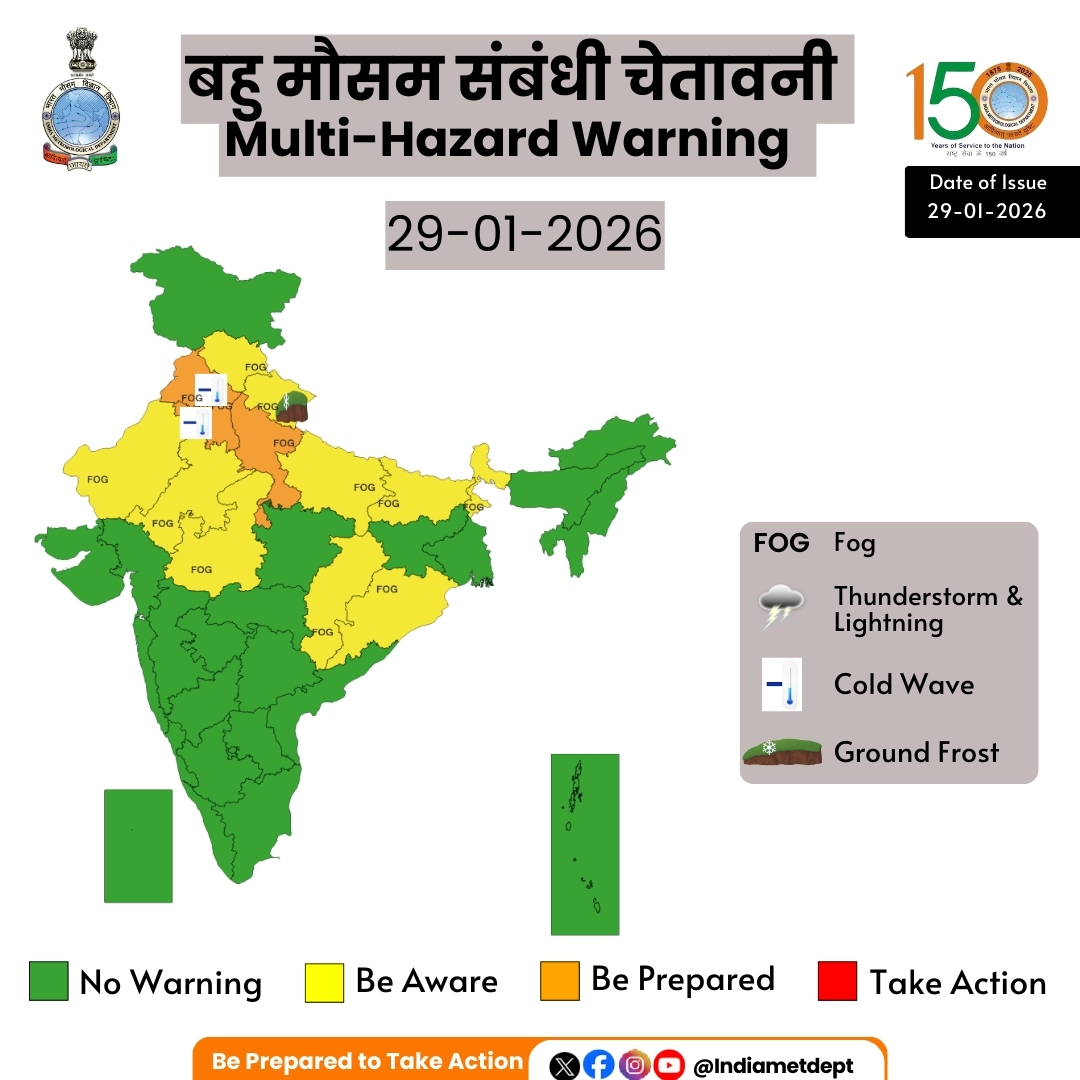
बहु मौसम संबंधी चेतावनी
मुख्यबिंदु:
एक के बाद एक, दो पश्चिमी विक्षोभ के असर से, 31 जनवरी-3 फरवरी के दौरान पश्चिमी हिमालयी क्षेत्र में हल्की से मध्यम छिटपुट/काफी व्यापक वर्षा/बर्फबारी और उत्तर-पश्चिम भारत और मध्य भारत के आस-पास के मैदानी इलाकों में हल्की से मध्यम छिटपुट वर्षा होने की संभावना है।
उत्तर-पश्चिम और आस-पास के मध्य भारत के कुछ इलाकों में 31 जनवरी तक सुबह के समय घना कोहरा छाए रहने की संभावना है।
Highlights
Under the influence of two Western Disturbance in quick succession, light to moderate scattered/ fairly widespread rainfall/snowfall likely over Western Himalayan region and light to moderate isolated/scattered rainfall over adjoining plains of northwest India and Central India during 31st January to 3rd February 2026.
Dense fog conditions likely during morning hours in isolated pockets over northwest & adjoining central India till 31st January.
Forecast of minimum temperatures:
❖ No significant change likely over Northwest India during next 2 days; gradual rise by 3-5°C during subsequent 3 days and gradual fall by 2-4°C during subsequent 2 days thereafter.
❖ Gradual rise in minimum temperatures by 2-3°C likely over Central India during next 24 hours; gradual fall by 2-3°C during subsequent 2 days and no significant change thereafter.
❖ Gradual rise in minimum temperatures by 2-4°C likely over Maharashtra during next 4 days and no significant change thereafter.
❖ Rise in minimum temperatures by 3-5°C likely over Gujarat during next 2 days; gradual fall by 2-3°C during subsequent 3 days and rise by 2-3°C during subsequent 2 days thereafter.
❖ No significant change in minimum temperatures likely over rest parts of the country.
Dense Fog, Cold wave Warnings:
❖ Dense to very dense fog conditions likely during morning/night hours in some/isolated pockets over Punjab, Haryana, Chandigarh, Uttar Pradesh till 31st and dense fog conditions likely over isolated places over Himachal Pradesh, Uttarakhand, Rajasthan, Odisha, Sub-Himalayan West Bengal & Sikkim, Bihar till 31stJanuary and East Uttar Pradesh till 01st February.
❖ Cold wave conditions likely in isolated pockets over Punjab, Haryana, Chandigarh on 30th-31st January.
Weather Warning :
❖ Isolated light/moderate rainfall accompanied with thunderstorm, lightning very likely over Madhya Pradesh on 01st & 02nd February and Chhattisgarh on 02nd February.
❖ A fresh western disturbance is likely to affect northwest India from the night of 30th January 2026. Under its influence, scattered to fairly widespread rainfall/snowfall with thunderstorm, lightning & gusty winds speed reaching 30-40 kmph likely over Jammu-Kashmir-Ladakh-Gilgit-Baltistan-Muzaffarabad on 31st January and 01st February; Himachal Pradesh, Punjab, Haryana and Chandigarh on 01st February and Uttarakhand on 01st & 02nd February. Isolated light rainfall with thunderstorm, lightning likely over Rajasthan during 31st January- 03rd February.
❖ Ground frost conditions likely to prevail over Uttarakhand on 29th & 30th January.
For more information, visit Us : mausam.imd.gov.in
#WeatherUpdate #WesternDisturbance #RainfallForecast #SnowfallAlert #DenseFog #ColdWaveWarning #TemperatureRise #Thunderstorm #IndiaWeather
@moesgoi @airnewsalerts @DDNational @ndmaindia @ICRER_MHA
1
3
23
1,668
Cold Wave Warning for Rajasthan (12.01.2026)
Cold wave to Severe Cold wave very likely over Rajasthan for 13th January 2026.
#ColdWave #SevereColdWave #WeatherAlert #ColdWaveWarning #Winter #WeatherUpdate #ColdWeatherSafety
@moesgoi @airnewsalerts @DDNational @ndmaindia @ICRER_MHA

3
1
1,117
Cold Wave Criteria for Coastal Stations:
A cold wave is declared when minimum temperature falls to 15°C or below.
Cold Wave: 4.5°C–6.4°C below normal
Severe Cold Wave: More than 6.4°C below normal
Stay alert, stay warm!
#ColdWaveWarning #WeatherUpdate #TemperatureDrop #ColdWeatherSafety #StayWarm #ColdWave #SevereColdWave #WeatherConditions #StayInformed
@PMOIndia @moesgoi @DrJitendraSingh @Ravi_MoES @ndmaindia @airnewsalerts @DDNewslive @PIB_India @mygovindia
1
3
13
1,754

ଆସନ୍ତା ୨୧ ଯାଏ ପ୍ରଚଣ୍ଡ ଥଣ୍ଡା, ସ୍ବାଭାବିକଠୁ ୬ ଡିଗ୍ରୀ ତଳେ ରହିବ ତାପମାତ୍ରା: ଜି.ଉଦୟଗିରିରେ ୨.୫ ଡିଗ୍ରୀ
#OdishaWeather #ColdWaveWarning #Fogalert #PrameyaOdia #PrameyaDigital
prameya.com/odisha-weather-a…
2
59
Cold wave conditions in hilly regions!
In hilly regions, a cold wave is declared when minimum temperatures drop significantly below normal.
🔹 Cold Wave: Temperature departure is 4.5°–6.4°C below normal
🔹 Severe Cold Wave: Temperature departure is 6.5°C or more below normal
📍 If at least two weather stations in a subdivision record these conditions for two consecutive days, a cold wave is officially declared on the second day.
Stay warm and stay informed!
#ColdWaveWarning #WeatherUpdate #HillyRegions #TemperatureDrop #StayWarm #ColdWave #SevereColdWave #WeatherSafety #WeatherConditions #StayInformed
@PMOIndia @moesgoi @DrJitendraSingh @Ravi_MoES @ndmaindia @airnewsalerts @DDNewslive @PIB_India @mygovindia
4
24
15,862

14 Dec 2025
❄️ Cold Wave Warning ❄️
Cold wave conditions are likely to continue at isolated places over Telangana & Interior Karnataka on 15th–16th December, with severe cold wave conditions over North Interior Karnataka on 15th December.
🌬️ Chilly winds can impact health—stay warm, layer up, keep homes heated, drink warm fluids, and protect crops & livestock from frost.
Stay safe and take precautions! 🧣🔥
#ColdWaveWarning #ChillyWeather #StayWarm #HealthPrecautions #WinterSafety #FrostProtection #TelanganaWeather #KarnatakaWeather #ColdWaveConditions #WarmFluids #ProtectCrops #SevereCold #WinterTips
@moesgoi @airnewsalerts @DDNational @ndmaindia @ICRER_MHA
8
54
15,210
13 Dec 2025
❄️ Cold Wave Warning ! ❄️
Cold wave conditions are expected across parts of Telangana, Interior Karnataka, Chhattisgarh, and Odisha, with severe cold wave likely in North Interior Karnataka on Dec 14.
🌬️ Chilly winds can affect health and livelihoods.
👉 Stay warm with layered clothing
👉 Keep homes heated & drink warm fluids
👉 Protect crops and livestock from frost
Stay safe and take precautions!
#ColdWaveWarning #WinterWeather #StayWarm #HealthPrecautions #ChillyWinds #ProtectYourself #CropProtection #LivestockCare #WeatherAlert #SafetyFirst
@moesgoi @airnewsalerts @DDNational @ndmaindia @ICRER_MHA
15
89
16,632
9 Dec 2025
🌡️ Cold Wave Warning !
Chhattisgarh, Maharashtra, Karnataka, Odisha, Punjab, Telangana, Vidarbha & West MP may see severe cold till Dec 10.
Stay warm, stay indoors when possible, and look out for kids, elders & those in need. ❄️
#ColdWaveWarning #StayWarm #WinterSafety #Chhattisgarh #Maharashtra #Karnataka #Odisha #Punjab #Telangana #WestMP
@moesgoi @airnewsalerts @DDNational @ndmaindia @ICRER_MHA
1
8
51
11,426
8 Dec 2025
Cold Wave Warning !
Cold wave conditions are likely to persist over Central, East & Northern Peninsular India from 09–12 December, and commence over Northwest & West India from 10–12 December 2025.
Citizens are advised to take necessary precautions and stay updated with official weather bulletins. ❄️
#ColdWaveWarning #WeatherAlert #IndiaWeather #Winter2025 #StaySafe #ColdConditions #WeatherUpdate #CentralIndia #EastIndia #NorthernIndia #NorthwestIndia #WestIndia #StayInformed
@moesgoi @airnewsalerts @DDNational @ndmaindia @ICRER_MHA
34
67
2,994
7 Dec 2025
Cold Wave Warning!
Cold wave conditions are likely over parts of Madhya Pradesh, Vidarbha, Chhattisgarh & Odisha on 8–9 December. Stay warm, stay safe!
#ColdWaveWarning #MadhyaPradesh #Vidarbha #Chhattisgarh #Odisha #StayWarm #StaySafe #WeatherAlert #WinterSafety #ColdWeatherTips
@moesgoi @airnewsalerts @DDNational @ndmaindia @ICRER_MHA
3
14
2,293
6 Dec 2025
⚠️ Cold Wave Warning :
Cold wave conditions are very likely over isolated pockets of Punjab, Haryana (7th, 10th–11th), West Madhya Pradesh & Vidarbha (7th–8th), East Madhya Pradesh & Chhattisgarh (7th), and Jharkhand & Odisha (7th December).
Citizens are advised to take necessary precautions. ❄️
#ColdWaveWarning #WeatherAlert #Punjab #Haryana #MadhyaPradesh #Vidarbha #Chhattisgarh #Jharkhand #Odisha #StayWarm #SafetyFirst #WinterPreparedness
@moesgoi @airnewsalerts @DDNational @ndmaindia @ICRER_MHA
8
25
3,778
28 Nov 2025
28 नवंबर, 2025 के लिए मौसम की चेतावनी
#IISF2025 #CyclonicStormDitwah #BayOfBengal #HeavyRainfall #TamilNadu #Puducherry #AndhraPradesh #Rayalaseema #WeatherForecast #MinimumTemperature #ColdWaveWarning #DenseFog #HimachalPradesh #DelhiWeather #RajasthanWeather #IndiaWeatherUpdates
@moesgoi @airnewsalerts @DDNational @ndmaindia @ICRER_MHA
2
16
3,470
28 Nov 2025
दैनिक मौसम परिचर्चा (28.11.2025)
चक्रवाती तूफान दितवाह के कारण तमिलनाडु और पुडुचेरी में 28-30 नवंबर के दौरान और तटीय आंध्र प्रदेश और रायलसीमा में 29 नवंबर से 1 दिसंबर के दौरान भारी से अत्यंत भारी वर्षा होने की संभावना है।
YouTube : youtu.be/d0YNw9ldFPs
Facebook : facebook.com/share/v/1BaFpTr…
भारत का सबसे बड़ा विज्ञान और नवाचार महोत्सव IISF2025 में भाग लेने के लिए पंजीकरण करें:iisf-registration.eventstrat…
#IISF2025 #CyclonicStormDitwah #BayOfBengal #HeavyRainfall #TamilNadu #Puducherry #AndhraPradesh #Rayalaseema #WeatherForecast #MinimumTemperature #ColdWaveWarning #DenseFog #HimachalPradesh #DelhiWeather #RajasthanWeather #IndiaWeatherUpdates
@moesgoi @airnewsalerts @DDNational @ndmaindia @ICRER_MHA
3
16
3,265
28 Nov 2025
Weather warning for 28th November 2025
#IISF2025 #CyclonicStormDitwah #BayOfBengal #HeavyRainfall #TamilNadu #Puducherry #AndhraPradesh #Rayalaseema #WeatherForecast #MinimumTemperature #ColdWaveWarning #DenseFog #HimachalPradesh #DelhiWeather #RajasthanWeather #IndiaWeatherUpdates
@moesgoi @airnewsalerts @DDNational @ndmaindia @ICRER_MHA
3
14
3,484