

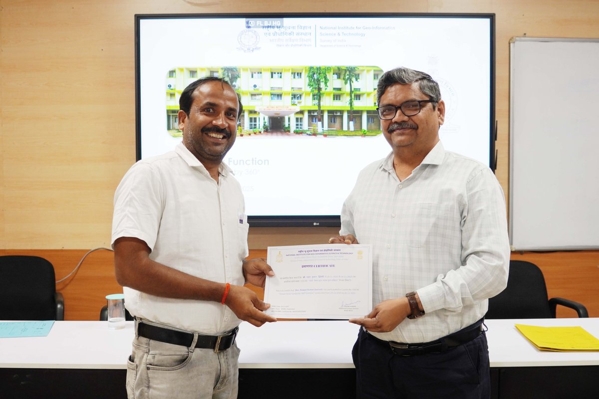
Feb 17
NIGST completed a 5-day training on Field Data Updation using FDC (09–13 Feb 2026) for 15 officials from NLCS, Bhutan.
Hands-on exposure to GNSS, CORS & GIS-based field data workflows.
#NIGST #SurveyOfIndia #Bhutan #GeospatialTraining
3
70

1 DAY TO GO!
Tomorrow, hands-on training in Drone Piloting, GIS, AutoCAD & DGPS begins at Geoinfo Academy.
Building the skills that define modern geospatial professionals.
📅 Starts Jan 22, 2026
📍 Lagos | Abuja
#GeospatialTraining #GIS #DroneMapping #Surveying Daddy Freeze

5
71
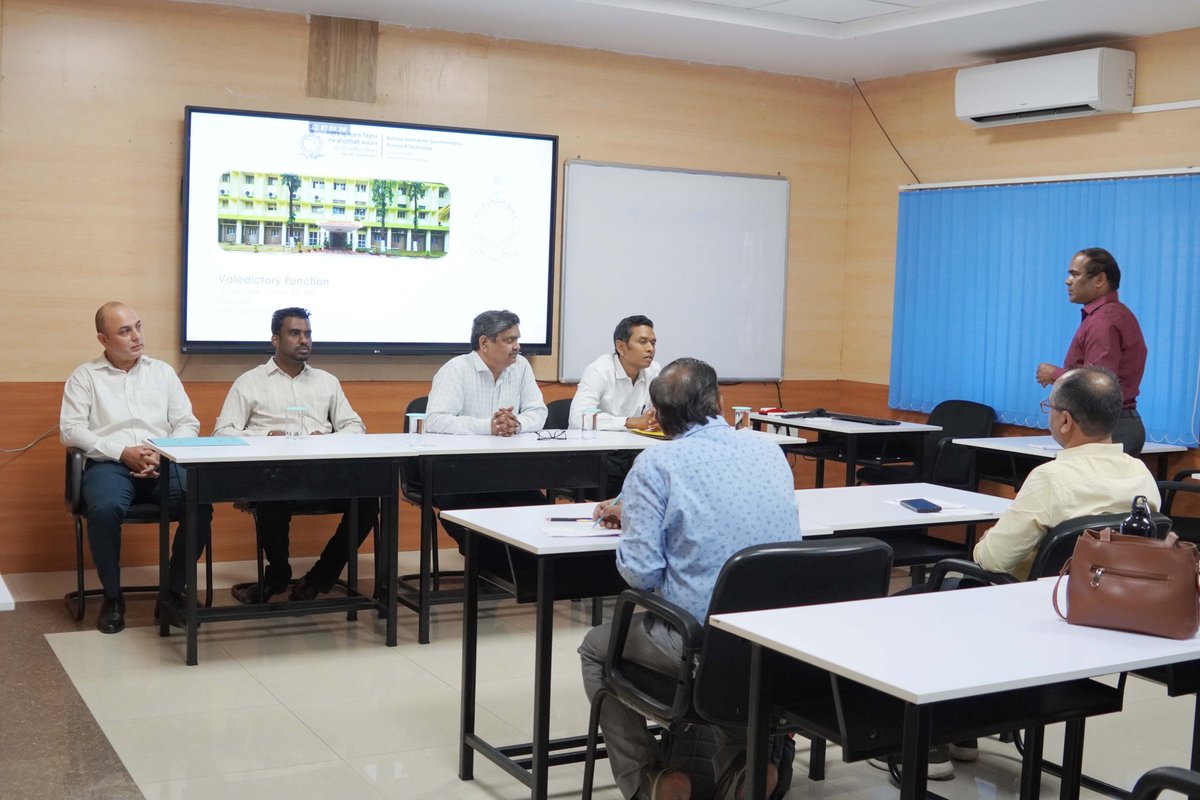
27 Nov 2025
NIGST concludes the 3-day training on Street View Survey by 360° Camera (24–26 Nov 2025).
Inaugurated by Addl. SG & Head, NIGST, the course covered 360° data capture, geotagging, stitching & GIS visualization.
#NIGST #SurveyOfIndia #GeospatialTraining

2
29
Join our Exclusive Masterclass training starting today, as we will be equipping students, professionals, and researchers with hands-on, industry-relevant training in:
• Drone Technology
• GIS (Geographic Information System)
• AutoCAD (For Surveying and Mapping)
• Differential GPS/GNSS RTK
Training starts today, 25th September, 2025.
Location: Ikeja, Lagos and Herbert Macaulay Way, Abuja, Nigeria.
Call/WhatsApp: 234 707 070 8909
🌐geoinfoacademy.com
#GIS #DroneMapping #AutoCAD #DGPS #Geoacademy #GeoinfoAcademy #Techskills #GISTraining #GeospatialTraining #GNSSRTK #AutoCAD #SpatialAnalysis #Surveying #RemoteSensing
6
58
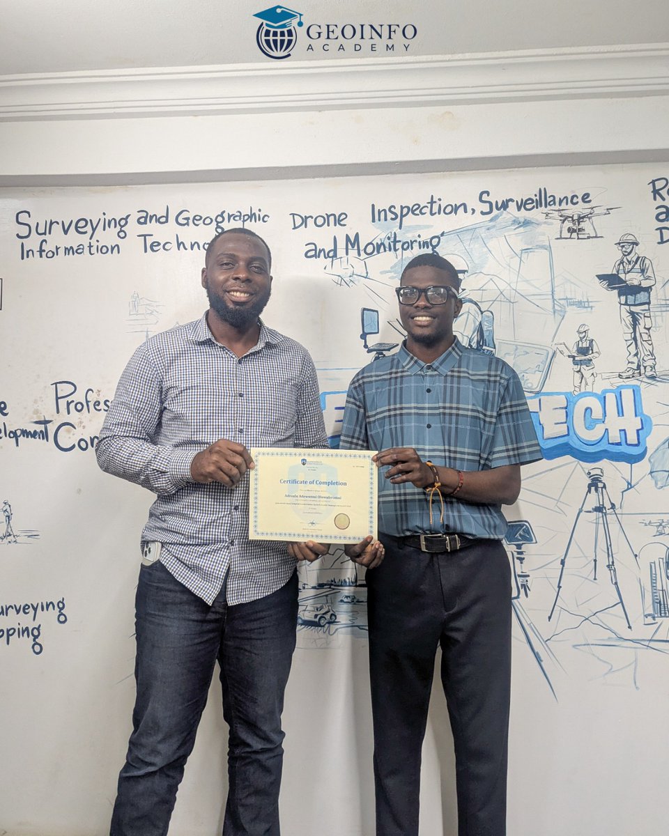
Congratulations to our newest GIS Certified Graduate! 🎉 Your commitment to mastering geospatial tools is truly inspiring.
This certification marks the beginning of an exciting journey in the tech world.
Ready to improve your Geospatial Career?
Join our upcoming training starting September 25, 2025, in Lagos and Abuja.
Let's unlock your potential together!
Get in Touch:
Visit: geoinfoacademy.com
234 707 070 8909
#GISCertification #GeospatialTraining #DronePilot #AutoCAD #STEMEducation #NigeriaTech #CareerGrowth #DifferentialGPS #GNSS


8
80

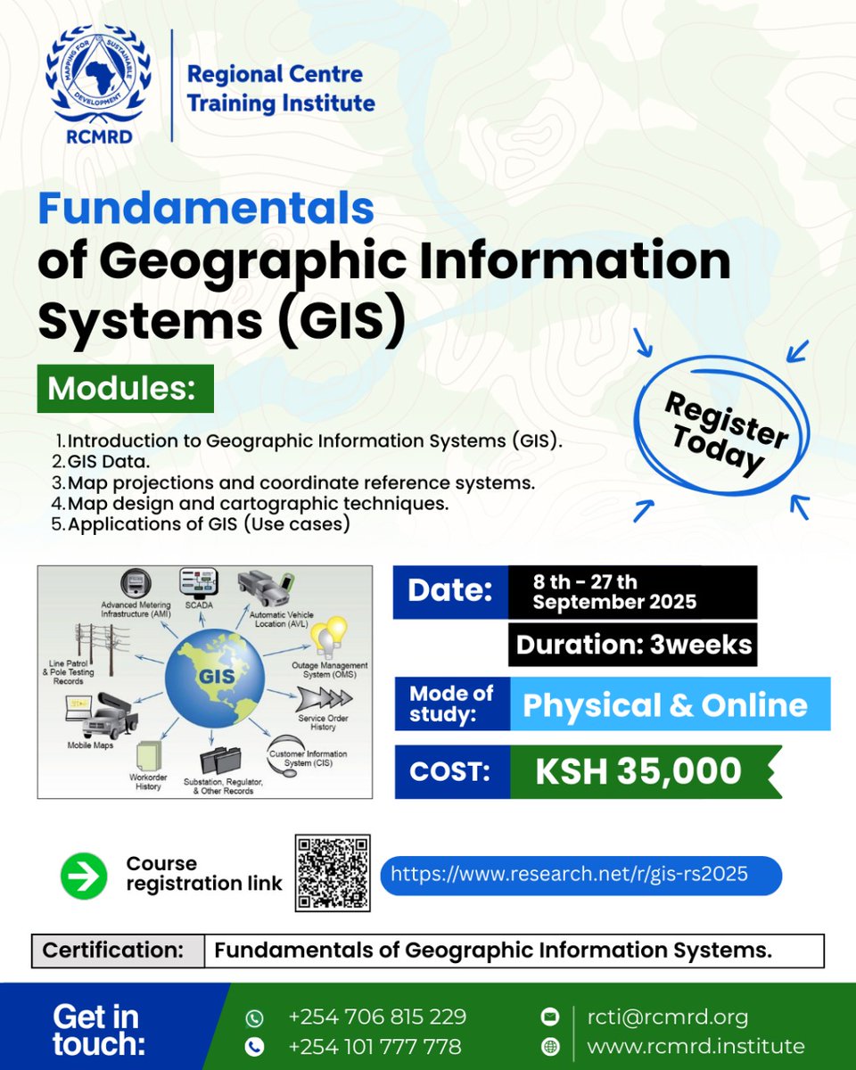
Our 𝐅𝐮𝐧𝐝𝐚𝐦𝐞𝐧𝐭𝐚𝐥𝐬 𝐨𝐟 𝐆𝐞𝐨𝐠𝐫𝐚𝐩𝐡𝐢𝐜 𝐈𝐧𝐟𝐨𝐫𝐦𝐚𝐭𝐢𝐨𝐧 𝐒𝐲𝐬𝐭𝐞𝐦𝐬 (𝐆𝐈𝐒) course kicked off today.
Book your slot to train with experts, and gain hands-on skills plus a recognized certificate.
Register immediately 👉 research.net/r/gis-rs2025
#RCTI #FundamentalsOfGIS #GeospatialTraining
2
6
256
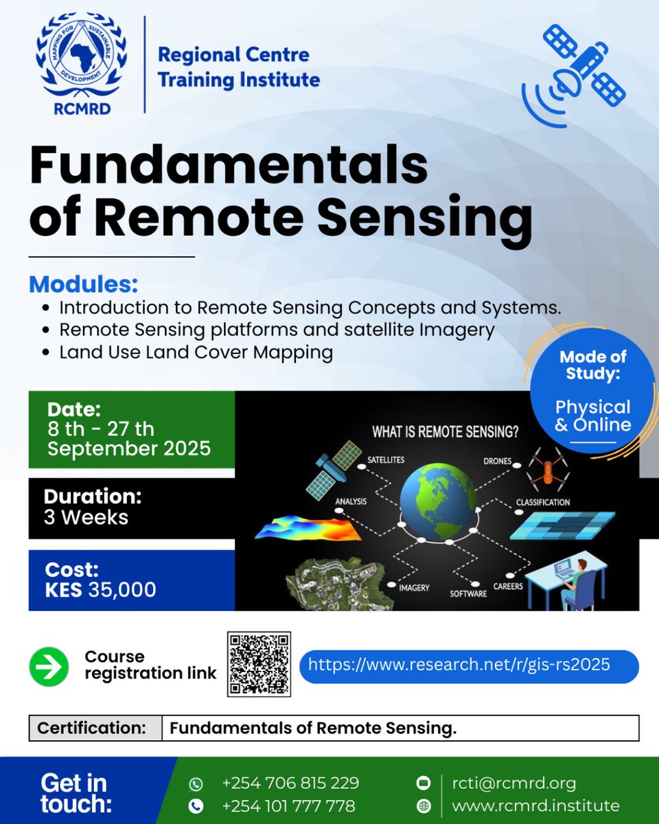
Our 𝐅𝐮𝐧𝐝𝐚𝐦𝐞𝐧𝐭𝐚𝐥𝐬 𝐨𝐟 𝐑𝐞𝐦𝐨𝐭𝐞 𝐒𝐞𝐧𝐬𝐢𝐧𝐠 course kicked off today.
Apply to train with experts, gain practical skills, and earn a recognized certificate in Geospatial training — available in both 𝐩𝐡𝐲𝐬𝐢𝐜𝐚𝐥 and 𝐨𝐧𝐥𝐢𝐧𝐞 𝐦𝐨𝐝𝐞𝐬.
Register now 👉 research.net/r/gis-rs2025
#RCTI #GeospatialTraining
1
11
335

19 Aug 2025
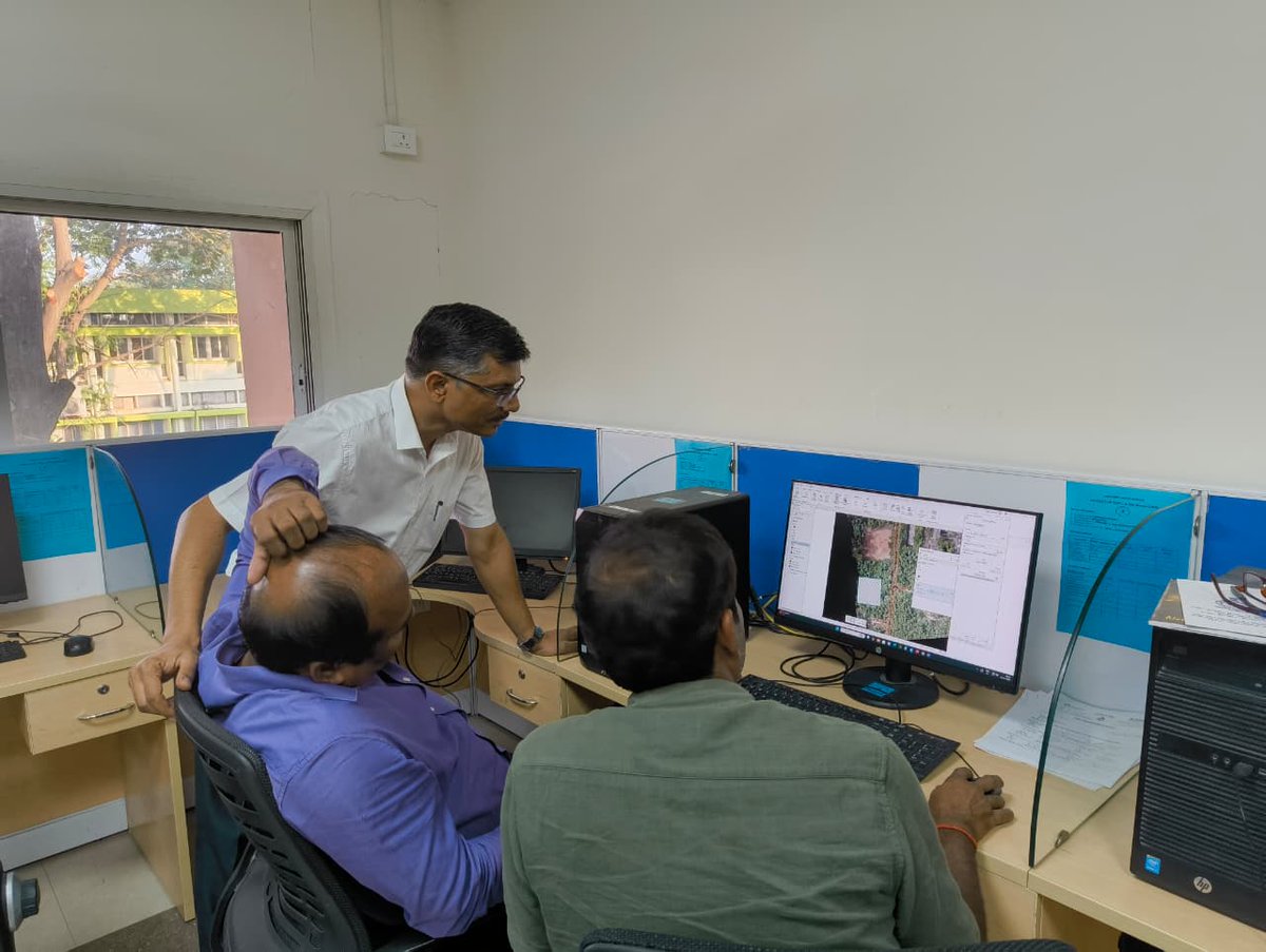
Meghalaya & Arunachal Pradesh Geospatial Directorate, Survey of India conducted a two-day training programme under the NAKSHA Training Programme for SPMU-NAKSHA, Shillong, on 4th and 5th August 2025 at the office of Digital India Land Records Modernization Programme (DILRMP), Shillong.
The programme aimed to strengthen the technical skills of field surveyors in modern geospatial technologies. The participants were introduced to the fundamentals of GNSS and CORS-based surveying followed by comprised practical sessions, including GNSS Rover and Electronic Total Station (ETS) operations, along with feature extraction from ortho-rectified imagery.
The programme concluded successfully with an interactive session emphasising the critical role of GNSS and CORS in achieving accurate and reliable survey results, in line with the objectives of the NAKSHA Project.
@DrJitendraSingh @karandi65 @IndiaDST
#SurveyofIndia #NAKSHA #GeospatialTraining #GNSS #CORS #FieldSurvey #ElectronicTotalStation #OrthoRectifiedImagery #SkillDevelopment #ModernSurveying #MappingTheFuture #GeospatialInnovation
9
316
TGIF!
As we navigate one more successful week, the future of geospatial learning looks brighter than ever!
From all of us at Geoinfo Academy, have a wonderful weekend ahead.
FOOTBALL IS BACK | No is No | The Club | Mercy Chinwo | #geoinfoacademy #Tgif #geospatialtraining


1
4
106
8 Aug 2025
The Punjab, Haryana, Himachal Pradesh & Chandigarh Geospatial Directorate, Survey of India conducted the Phase-III training programme at the Mahatma Gandhi State Institute of Public Administration (MGSIPA), Chandigarh, from 30th July to 1st August 2025. The training provided valuable insights into advanced geospatial technologies.
The team delivered comprehensive lectures, conducted detailed demonstrations of geospatial instruments, and provided hands-on training with equipment such as the rover and Electronic Total Station (ETS). In addition, the training covered the important CORS registration process, equipping participants with practical knowledge essential for the effective application of these technologies.
This training programme was a key initiative in strengthening the technical capabilities of participants and contributing to the broader objectives of geospatial advancement in India.
@DrJitendraSingh @karandi65 @IndiaDST
#SurveyofIndia #GeospatialTraining #GeospatialTechnology #CORS #DataDrivenIndia #SkillDevelopment #GeospatialExcellence
1
5
262

5 Aug 2025
For more information about registration, visit our website: studyhacksgeospatial.com/goo…
#GoogleEarthEngine #RemoteSensingTraining #GISAnalysis #GeospatialData #EarthObservation #RemoteSensing #SpatialAnalysis #GeospatialTraining #LULCMapping #ChangeDetection #MachineLearningGIS

6
38
1,427
21 Jul 2025
For more information about registration, visit our website: studyhacksgeospatial.com/goo…
#GoogleEarthEngine
#RemoteSensing
#GISAnalysis
#GeospatialTraining
#GEETraining
#JavaScriptGIS
#PythonGIS
#EarthObservation
#SatelliteImagery
#NonCodersWelcome
#OnlineTraining
#GeospatialSkills

1
15
644
16 Jul 2025
Jammu & Kashmir and Ladakh Geospatial Directorate, Survey of India conducted a technical training programme for the field staff of the Revenue Department of Jammu and Kashmir (UT) for ground truthing and attribute collection under the 3rd phase of the "NAKSHA Project" initiative. The programme was held from 12th to 14th July 2025 at the Revenue Training Institute in Srinagar, Jammu & Kashmir. The objective of the programme was to enhance geospatial capabilities at the Urban Local Body (ULB) level through a combination of classroom instructions and field demonstrations.
The training session was led by three Survey of India officials. The classroom sessions covered key topics, including the applications of GNSS, ETS, CORS Network, and NRTK, followed by practical demonstrations on GNSS observations and Electronic Total Station (ETS) surveying, with a focus on data integration with GIS platforms.
This initiative underscores Survey of India’s commitment to technical capacity building and its ongoing support for the successful implementation of the NAKSHA programme, in line with the broader goals of Digital India and enhanced urban governance.
@DrJitendraSingh @karandi65 @IndiaDST @DoLR_MoRD @revenuejnk
#SurveyofIndia #NAKSHAProject #GeospatialTraining #DigitalIndia #UrbanGovernance #GNSS #CORSNetwork #NRTK #FieldSurvey #GISIntegration
3
12
502
7 Jul 2025
For more information about registration, visit our website: studyhacksgeospatial.com/goo…
#GoogleEarthEngine #RemoteSensing #GIS #GeospatialTraining #OnlineTraining #EarthObservation #SatelliteImagery #GEEforBeginners #GEEwithPython #GEEwithJavaScript #NDVI #LULCMapping

9
66
2,522
12 Jun 2025
Survey of India conducted a technical training programme for Master Trainers under the “NAKSHA Project” initiative from 2nd to 7th June 2025 at the Centre of Excellence – LAM, YASHADA, Pune. The programme aimed to build geospatial capabilities at the Urban Local Body (ULB) level through a blend of classroom instruction and field demonstrations.
Under the guidance of the Director, Maharashtra and Goa Geospatial Directorate Pune, four Survey of India officials led the sessions. Classroom training covered topics like datums, GNSS, CORS Network, and NRTK applications, followed by hands-on demonstrations in GNSS RTK mode and Electronic Total Station (ETS) surveying, including data integration with GIS platforms.
This initiative highlights Survey of India’s commitment to technical capacity building and its continued support for the effective implementation of the NAKSHA programme, aligned with the broader goals of Digital India and improved urban governance.
@DrJitendraSingh @karandi65 @IndiaDST
#SurveyofIndia #NAKSHA #GeospatialTraining #GNSS #CORS #ETS #YASHADA #UrbanGovernance #CapacityBuilding #DigitalIndia #GroundTruthing #UrbanPlanning
1
9
281
6 Jun 2025
The trainees from the Lal Bahadur Shastri National Academy of Administration (LBSNAA), Mussoorie participated in Geospatial training under the NAKSHA (National Geospatial Knowledge-based Land Survey of Urban Habitations) Program on 5th June 2025 in the office of Uttrakhand Geospatial Directorate, Survey of India, Dehradun.
The training session featured demonstrations and hands-on exercises on ground survey techniques using GNSS Rovers supported by Continuously Operating Reference Stations (CORS), Total Station instrument and data processing and editing in a lab.
This comprehensive session was conducted by experts from the Uttarakhand Geospatial Directorate, Geodetic and Research Branch (G&RB), Dehradun, and the National Institute for Geo-informatics Science & Technology (NIGST), Hyderabad. The trainees gained valuable practical experience in modern geospatial technologies, data acquisition, and processing techniques—skills essential for informed planning and decision-making in governance and administration.
@DrJitendraSingh @karandi65 @IndiaDST
#SurveyOfIndia #NAKSHAProgram #LBSNAA #GNSS #GeospatialTraining #Surveying #CapacityBuilding #UKGD #NIGST #MasterTrainerTraining
2
2
17
474
20 May 2025
As part of the Forest Survey Course for IFS (Probationers) 2024–26, the Geodetic & Research Branch, Survey of India had the privilege of engaging with 114 Indian Forest Service (IFS) Probationers through a series of academic and field-based learning sessions.
From 5th to 9th May 2025, the officers participated in a week-long training programme at IGNFA, Dehradun, featuring comprehensive lectures on Geodesy, GNSS, and Surveying by Shri Bhaskar Sharma and Shri CHVSS Prasad, Officer Surveyors from NIGST, Hyderabad. These sessions were complemented by hands-on practicals led by the UKGD team of Survey of India.
As a continuation of this initiative, the probationers visited the G&RB Museum on 14th and 15th May 2025, where they explored the Survey Museum and were introduced to the Continuously Operating Reference Station (CORS) infrastructure. The visit provided first-hand insights into the application of geospatial and geodetic technologies in natural resource management and environmental governance.
The Survey of India extends sincere thanks to Shri Kunal Angrish, Course Director, for his efforts in coordinating both the training and the visit. The occasion was marked by a warm exchange, with the officers presenting a memento to Survey of India officials—symbolising institutional collaboration and mutual respect.
@DrJitendraSingh @karandi65 @IndiaDST
#SurveyOfIndia #IFSProbationers #IGNFA #NIGST #ForestSurvey #GeospatialTraining #Geodesy #GNSS #CORS #GnRBMuseum #CapacityBuilding #NaturalResourceManagement #InstitutionalCollaboration
2
7
204
3 Mar 2025
NIGST successfully conducted a six-day Master Trainer program under the NAKSHA
#NAKSHA #GeospatialTraining #CORS #ETS #Surveying #Mapping #GIS #MasterTrainers #SkillDevelopment #TechForGood
2
3
47
Enhance your geospatial skills with our 𝐃𝐫𝐨𝐧𝐞 𝐌𝐚𝐩𝐩𝐢𝐧𝐠 & 𝐈𝐦𝐚𝐠𝐞 𝐏𝐫𝐨𝐜𝐞𝐬𝐬𝐢𝐧𝐠 𝐂𝐨𝐮𝐫𝐬𝐞!
📅 February 17-21, 2025
📍 RCMRD, opposite Kasarani Police Station, Nairobi
🏫 In-person learning
💰 Ksh 40,000
Scan the QR code to register now!
📞 Call/WhatsApp: 𝟎𝟏𝟎𝟏 𝟕𝟕𝟕 𝟕𝟕𝟖 or 𝟎𝟏𝟏𝟒 𝟒𝟒𝟒 𝟒𝟔𝟎.
📧 𝐫𝐜𝐭𝐢@𝐫𝐜𝐦𝐫𝐝.𝐨𝐫𝐠, 𝐦𝐦𝐮𝐫𝐢𝐦𝐢@𝐫𝐜𝐦𝐫𝐝.𝐨𝐫𝐠
#DroneMapping #ImageProcessing #GeospatialTraining #RCMRD

1
6
18
909