
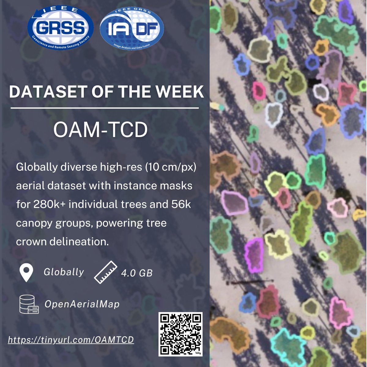
📢 Introducing the OAM-TCD Dataset!
🌎 High-resolution aerial image tiles from around the world, spanning diverse terrestrial biomes, urban, and natural environments.
🛰️ Sourced from OpenAerialMap (OAM) user-contributed UAV and aerial RGB surveys.
📏 10 cm/px resolution with 2048x2048 px GeoTIFF tiles (>20k hectares total).
🧩 Instance-level polygon masks for 280k individual trees and 56k canopy groups.
🔎 Ideal for tree crown delineation, canopy cover mapping, and DL-based ecological monitoring.
📄 Dataset: eod-grss-ieee.com/dataset-de…
#IEEEGRSS #IADF #RemoteSensing #EarthObservation #TreeDetection #TreeCrownDelineation #AerialImagery #ForestRestoration #DeepLearning
12
51
2,603

Apr 1
Advanced Imagery Tools
• OpenAerialMap, https://map[.]openaerialmap[.]org/ - A compilation of tools allowing users to search, share, and view satellite and UAV imagery.
10/12
1
1
441

26 Sep 2025
#sa2025jp 受講生各位 今日のタイル生成用サンプルデータ 「鹿沢空撮オルソ」はOpenAerialMapに公開している。こちらからGeoTIFFファイルをダウンロードしてください。
17 Sep 2025

#sa2025jp 受講生各位
今日のタイル生成用サンプルデータ
「鹿沢空撮オルソ」はOpenAerialMapに公開している。こちらからGeoTIFFファイルをダウンロードしてください。
oin-hotosm-temp.s3.amazonaws…
3
471
17 Sep 2025
#sa2025jp 受講生各位
今日のタイル生成用サンプルデータ
「鹿沢空撮オルソ」はOpenAerialMapに公開している。こちらからGeoTIFFファイルをダウンロードしてください。
oin-hotosm-temp.s3.amazonaws…
3
1,352

23 Jul 2025
🎧New ep with @hotosm team
Explore #OpenAerialMap - a platform fondly referred to as the @openstreetmap for imagery - making free drone & satellite imagery accessible to all
We explored:
Use cases, challenges, and what’s next (v2!)
Listen: shorturl.at/EXOQO
#GIS
1
3
380

16 Jul 2025
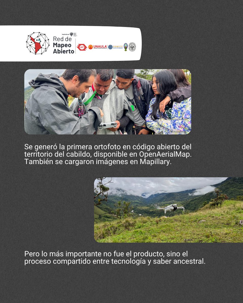
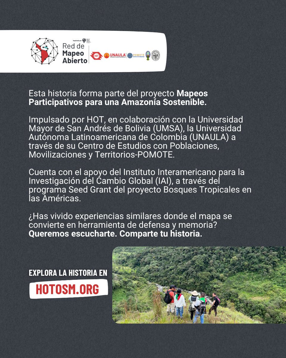
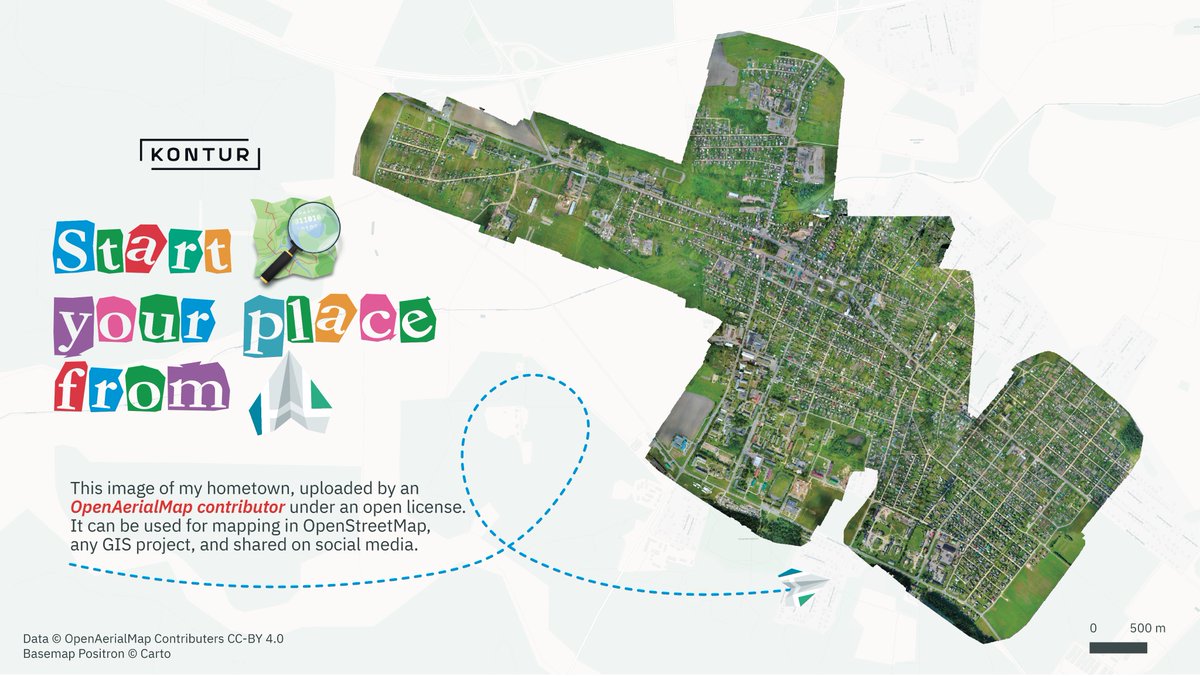
🗺️Se generó la primera ortofoto libre del cabildo en #OpenAerialMap y 100 fotos en #Mapillary.
Lo más valioso: el proceso: una conexión entre tecnología y saber ancestral.
🌿 El proyecto es apoyado por @IAI_news. Explora la historia: buff.ly/udjSjrI
3
4
153


4 Apr 2025
14. OpenAerialMap - Aerial imagery collected by individuals and organizations.
openaerialmap.org/
15. Global Forest Watch - Forest change, loss, and gain raster data.
globalforestwatch.org/
1
2
519
12 Jan 2025
2
4
101

12 Jan 2025
画像自体が公開可能出れば、openaerialmapにあげてしまえば、きっとタイルを作ってくれたような・・・。 map.openaerialmap.org/#/139.… どうだっけ? @mapconcierge
2
3
1,706

19 Dec 2024
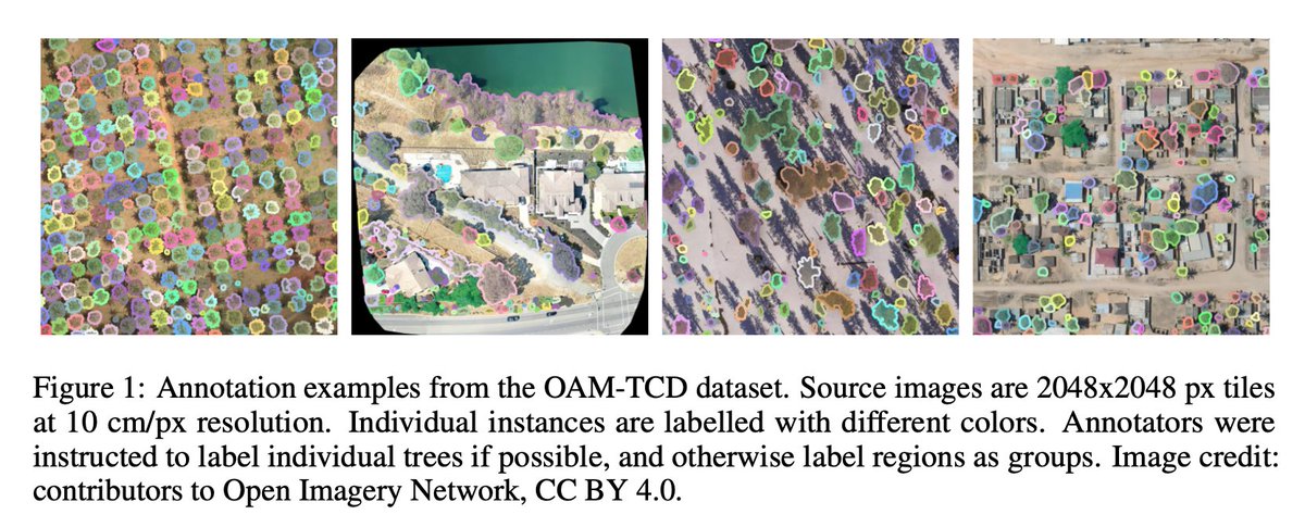
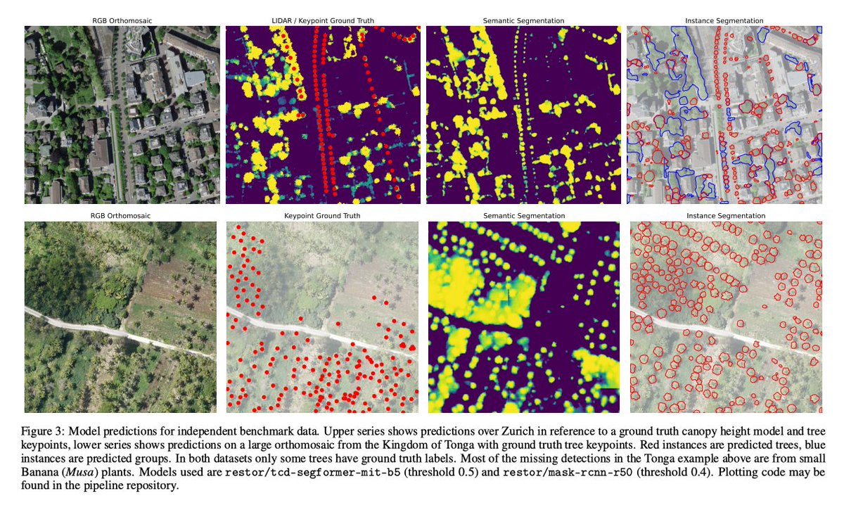
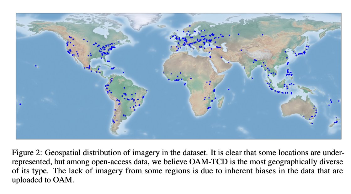
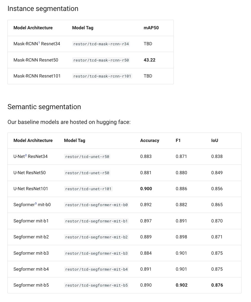
OAM-TCD: A globally diverse dataset of high-resolution tree cover maps
@drjoshvm @andrewcottam @DaniellaSchwei2 @ce_zhang @dwddao et al.
tldr: 280k trees labeled for semantic & instance segmentation in 5k 10cm aerial imaged sourced from OpenAerialMap
restor-foundation.github.io/…
1
5
127

6 Nov 2024
#30DayMapChallenge Day 6: Raster
Into aerial photography but don’t know where to host your imagery? 📸✈️ Check out openaerialmap.org! Our colleague created this map to showcase this perfect solution. #OpenAerialMap
7
180

2 Oct 2024
@kenzkenz さんが個人で地道に開発してきた Open-Hinata が完成!祝!
#DRONEBIRD レイヤーも標準装備です!これをもって、我々 @dronebirds もメインの空撮データ提供ツールはひなたGISから Open-Hinata に移行しようと思います。Permalink URL も短縮化されて使いやすい!
kenzkenz.xsrv.jp/open-hinata…
#DRONEBIRDsAREGO #OpenHinata #JapanFlyingLabs #CrisisMappersJapan #OpenAerialMap #FuruhashiLab #古橋研究室 #PoliMI #AoyamaGSC

7
35
4,314

1 Oct 2024
Santa Clara - Yarinacocha 30/9/2024 map.openaerialmap.org/#/-74.… #osm #openstreetmap #aom #openaerialmap

2
57
1 Oct 2024
Puerto Firmeza - Yarinacocha 28/9/2024 map.openaerialmap.org/#/-74.… #osm #openstreetmap #aom #openaerialmap

2
67
7 Aug 2024
2 Aug 2024
XYZタイル生成実習のサンプルデータ(GeoTIFF)を #OpenAerialMap からダウンロードしてください!
#sa2024jp #古橋研究室
map.openaerialmap.org/#/138.…
4
532
2 Aug 2024
XYZタイル生成実習のサンプルデータ(GeoTIFF)を #OpenAerialMap からダウンロードしてください!
#sa2024jp #古橋研究室
map.openaerialmap.org/#/138.…
3
916
24 Jun 2024
能登半島地震で活用されたKDDI開発のSVGmapデフォルト背景地図は OpenStreetMap です。クライシスマッピングの成果はこういうツールに埋め込まれています。またDRONEBIRDレイヤも標準装備していて、我々がOpenAerialMap にオルソモザイク画像を公開すると自動的にSVGmapに取り込まれるようになっています。
#SVGmap #KDDI #OpenStreetMap #DRONEBIRD #古橋研究室
news.mynavi.jp/article/20240…
6
17
1,635
21 Jun 2024
#OpenDroneMap Global Meet-Up, #UR24
June 21th, 14:00-16:00 JST @ Room 409
The Noto Peninsula earthquake that occurred on January 1, 2024, caused the collapse of many buildings, spread of fire, tsunami, landslides, and other damage. At the same time, many government agencies and private companies utilized drones for emergency disaster response, mostly for aerial photography work to create orthomosaics to assess the damage. Open-source photogrammetry tools such as OpenDroneMap are essential when performing photogrammetry quickly and simultaneously. In this session, Stephen Mather, the main contributor of OpenDroneMap, and Taich Furuhashi, the leader of DRONEBIRD, a volunteer team of disaster emergency photographers, will hold a Meetup to exchange opinions about the current state of OpenDroneMap.
# Schedule
14:00-14:05 Opening
14:05-14:25 State of the OpenDroneMap by Stephen Mather
14:25-14:45 DRONEBIRDs ARE GO by Taichi Furuhashi
14:45-15:00 Q&A
15:00-15:55 OpenDroneMap Hands-On by Stephen Mather, India Johnson, Ivan Gayton
15:55-16:00 Closing
# Participants:
* Stephen Mather, Executive Director, Pixel Shepherd, and Interhuman Pixel Transfusion at OpenDroneMap.org
* India Johnson, CEO, UAVistas
* Ivan Gayton, Product Innovation and Humanitarian Advisor, Humanitarian OpenStreetMap
* Taichi Furuhashi, a.k.a. @mapconcierge, #DRONEBIRD / Aoyama Gakuin University, and UN OpenGIS Initiative
#AoyamGSC #UNOpenGIS #FuruhashiLab #HOTOSM #OpenAerialMap #OpenStreetMap

4
558