
SYSGO ofrece sus tecnologías de software crítico para reforzar el programa SAETA II de Airbus Defence and Space.
@SYSGO @AirbusDefence #SYSGO #SAETAII #AirbusDefenceAndSpace #PikeOS #ELinOS #SoftwareCritico #Defensa #Seguridad
digitalsecuritymagazine.com/…
digitalsecuritymagazine.com/…
8

Jun 9
btw lo q dices aplica solo si no tienes r5, si soy top tengo r5 mi responsabilidad es ganar linea en fase de pikeos, ahora q en algun invade muera jg y top y por eso termines perdiendo linea es otra cosa
4


Mar 16
-el modo te enseña el mapa y los picks mas usados en ese modo
-el rango te muestra el maximo rango de tus compañeros y una etiqueta sobre cuanto sabes
-la seccion de pikeos a la derecha para estar con el dedo pulgar y ser mas facil decontrolar ademas de deslizarse verticalmente
1
26
3,313


21 Jul 2025
HOW DOES AIR DEFENSE COMMAND AND CONTROL OPERATE?
This is an image of one of Pakistan’s air warfare ground control centers. These facilities are used to fuse a comprehensive picture of aerial activity, identify threats, coordinate own forces, and cue air defense.
As they say, a picture is worth a thousand words. Let’s examine what this one reveals.
Each operator’s station is configured with at least three displays. The top screen shows the real-time, sensor-fused air picture. Below it are two smaller screens likely displaying structured tables with tasking assignments, aircraft status and controller logs. This configuration is typical of modern, networked air defense environments built for rapid threat assessment and response.
The large map display shows a fused common operating picture constructed from multiple sensor inputs. These likely include ground-based radar systems such as the YLC-2V, TPS-77, or Giraffe AMB; airborne sensors from ZDK-03 and Erieye/GlobalEye AEW&C platforms; and secondary IFF interrogation data. In some configurations, civilian ADS-B overlays or passive emitter geolocation may supplement situational awareness. The PAF also uses Mobile Observer Units which can report information.
The resulting fused picture is not generated locally at each station. It is assembled by a central, fault-tolerant, high-performance server cluster which is ruggedized, air-gapped, and deployed with a dual-redundant architecture for uptime assurance. Deterministic fusion of multi-sensor data requires real-time middleware, low-latency buses, and dedicated hardware pipelines. This is not commercial software. It is defense-critical infrastructure.
The map’s purpose is to show track histories and current positions of friendly and adversary aircraft, boundaries of radar and SAM coverage, real-time Combat Air Patrols (CAPs), and intercept vectoring. Operators can re-task interceptors, reconfigure engagement zones, and assign targets to aircraft or ground-based systems from this view alone.
Below the map, the two tablet-style secondary displays likely show:
1. Aircraft type, ID, altitude, speed, heading
2. Controller assignment and ROE status
3. Radar locks or missile cueing
4. Sector transitions and workload tracking
5. Handoff instructions to AWACS or adjacent control sectors
Legacy ADGE operators often used stylus or light pen interfaces to select and annotate tracks. This image, though fuzzy, seems to show alternate input systems; possibly ruggedized trackballs, jog dials, or resistive touch screens.
The workstations themselves don’t reveal their operating systems. But in air-gapped military systems, the front-end UI may run on hardened Linux or Windows variants, while backend systems likely depend on real-time operating systems. Examples include QNX, FreeRTOS, RTEMS, PikeOS, and VxWorks. These systems support deterministic execution, interrupt-level control, and low-overhead communication. All of this is critical for time-sensitive fusion and weapon assignment. These systems, as a full stack, are put through rigorous security testing. In the US, this might be NIAP, Common Criteria and other tests and certifications.
Beyond the software, the system architecture almost certainly includes:
1. A secure data bus possibly DDS or a CAN-based RTNet variant
2. Shared memory models for radar and track fusion
3. Hardware cryptography and zero-trust enclave isolation
4. Voice/data relay capability between operators, control nodes (AWACS) and pilots, with data-only extending to RPVs and UCAVs
Secure interoperability is provided through Pakistan's Link-17 which is, by now, deeply integrated into Pakistani systems to enable secure, jamming resistant, long range bi-directional data exchange.
Rooms like these are almost certainly EMSEC-shielded and fiber-backboned (as copper poses an EMP threat), with redundant power, logging, and possibly hot-swap controller failover. It reflects a distributed sector-based command layout: each operator manages a defined airspace segment or altitude band. The common operating picture is updated continuously across all stations.
So, at first, what looks like a few workstations and a large display isn’t so simple. This coordination center is really a digital nervous system for national airspace sovereignty. It merges human decision-making with fused sensor intelligence in real time. It is one of the places where the "man" is "on the loop".
The fact that this particular image shows northern Pakistan and Kashmir is no accident. These are among the most surveilled and actively managed airspaces in the country.
Airspace can be weaponized in seconds. Command centers like these are an expression of sovereign control.
They are the ever-watching eye.

4
16
70
5,590

23 Mar 2025
🚀 Intel (INTC) Stock: Flying Higher with New Aerospace Alliance
1. Alliance Lift-Off 💥
Intel (NASDAQ:INTC) teamed up with Curtiss-Wright, SYSGO, and wolfSSL stock popped 2.5% to $24.26 on March 21, X is hyped.
2. Aerospace Bag Secured ✈️
New COTS solutions for safety-critical aerospace systems X vibes say it’s a military contract flex.
3. Tech Stack Slaps 🛠️
Intel’s 13th Gen Core i7, Curtiss-Wright’s boards, SYSGO’s PikeOS, wolfSSL’s bootloader X calls it a next-level combo.
4. Stock Glow-Up 📈
INTC hit $24.36 intraday high March 21, up from $23.96 close X stans the 1.25% climb amidst a choppy market.
5. Industrial Tea Spilled ☕
Beyond aerospace, this tech’s got industrial use X buzzing it’s a sleeper hit for Intel’s bag.
6. X Sentiment Goes Wild 🗣️
Posts flex “$INTC back in the game,” but some clown the “old chip vibes” split energy.
7. AMD Rivalry Vibes ⚔️
X notes AMD’s market share lead, but Intel’s $24.26 vs. $18.51 year-low screams comeback szn.
8. Wall St.’s Chill Take 🏦
Analysts still “hold” INTC, X roasts the caution despite aerospace W and $106B market cap.
9. Volume Fade Check 📉
Trading hit 24.9M shares March 21, down 65% from 71.6M avg X debates if the hype’s quiet.
10. HODL or Yeet? 🤔
X split: diamond hand INTC for aerospace growth or cash out at $24.26 before it dips?
Intel’s aerospace alliance got the stock wings X says it’s a glow-up, but is it enough to moon? What’s your play? 🌍
117
36
1,768

3 Mar 2025
SYSGO, a European supplier of RTOS has announced the official support of Intel’s 13th Gen Intel Core processor family functional safety-capable SoCs with its certified flagship PikeOS RTOS & Hypervisor.
Discover more, click the link below!👇
bit.ly/4i0wqX4
47

27 Nov 2024
Claro que Yes. Espera que pido unos pikeos y una chela. A porciento mañana es día de gracias una cenita con el equipo de trabajo puede sherr

6
393

12 Nov 2024
Ahorita me gusta es de D'Pikeos muy bueno, buen precio. De los del pasado que no existen era el MC Robert en Manuel Galecio. Para mi el de D' Pikeos vale la pena full
3
5
1,356

9 Oct 2024
El #pollitosolidario Segunda Temporada fue una realidad 🐤 antes hubo una primera entrega 🐤🤣 Gracias x unirse a esta iniciativa que incluyó víveres, piscina, pikeos, diversión, camaradería e integración; 3 de mis chicos del Malecón fueron parte d esta refrescante tarde 🤽♀️💧🙌🏽🐤
13
16
370

Ne ratez pas #RustParis2024 le 25 juin 2024 à l'@ISEP
Présentation : Rust et PikeOS pour la Cyberdéfense🕒14h35 – 15h05🎙️Thierry Maudire, SYSGO - Embedding Innovations & Pierre Boinet, Thales La Ruche.
server.matchmaking-studio.co…
@SYSGO @thalesgroup @Pole_Systematic
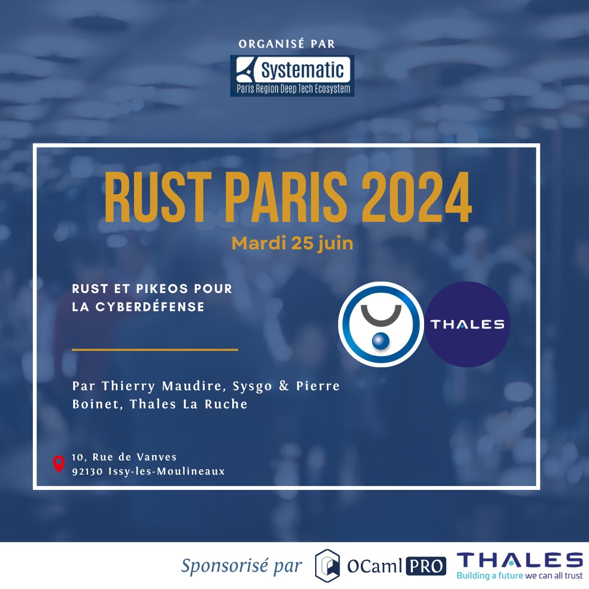
5
209

30 May 2024
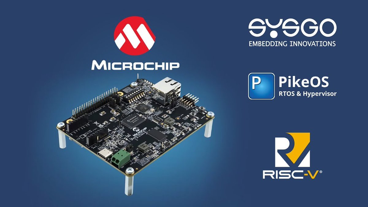
Watch @SYSGO’s webcast to learn how to set up and build SYSGO’s hard RTOS and Hypervisor PikeOS on the PolarFire® SoC Icicle Kit based on a #RISCV 64-bit SoC: hubs.la/Q02y-2b70 #RISCVeverywhere
3
14
1,726

26 Apr 2024
Learn about SYSGO’s Hard Real-Time Operating System (RTOS) and Hypervisor PikeOS on the PolarFire® SoC Icicle Kit. Explore the capabilities of RISC-V 64-bit SoC. Register for the free webinar: mchp.us/3Uu8vpq. @SYSGO #PolarFire #FPGAs #Security
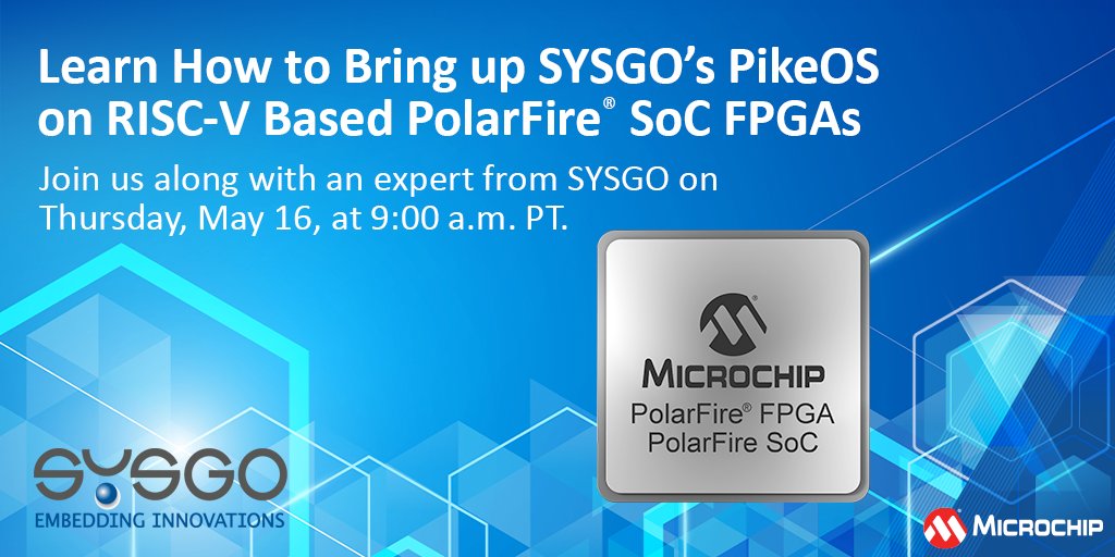
3
13
1,068
21 Apr 2024
Establish powerful security in your embedded system. Read the blog to learn more about PikeOS, developed by SYSGO GmbH and available for PolarFire® SoC FPGAs. mchp.us/49im5kP @SYSGO #RISCV #PolarFire #SoC #FPGA #RTOS
2
25
1,696

6 Apr 2024
Ai full sol 🥵 , como para unas heladas y unos pikeos 🤗
2
5
600
13 Mar 2024
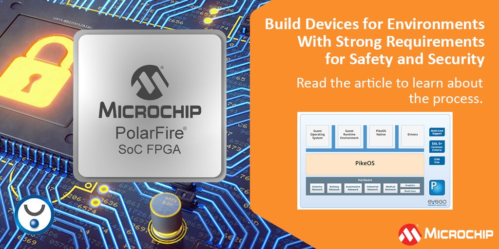
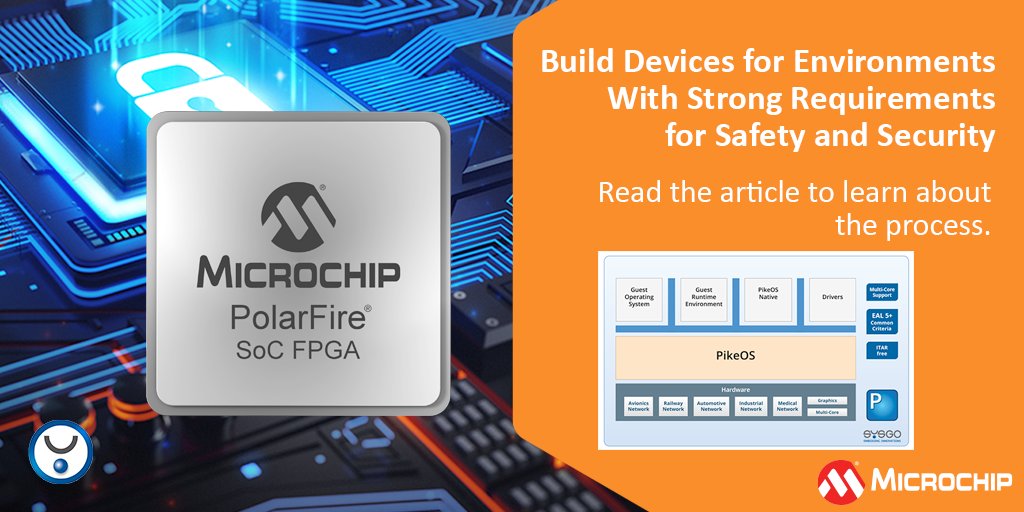
Read the blog featuring Simon Jakob of SYSGO GmbH for an overview of how PikeOS supports building devices for environments with strong requirements for safety and security. mchp.us/49im5kP @SYSGO #RISCV #PolarFire #SoC #FPGA #RTOS
1
6
675