
Fascinating Weather Phenomena - Firestorms
Bad weather and wildfires are dangerous forces in their own rights. What if I told you that wildfires could create their own bad weather? Its true. Intense heat from a large fire creates its own wind system by sending warm air and smoke skyward. This can create areas of suction at ground level that draws air in, creating fire tornadoes. High volumes of smoke can condense with water vapor in the air to create pyrocumulus clouds. These clouds can produce lightning which can strike and spread fire and high winds that spread flames. In some occasions, pyrocumulus formations have been known to rain. It's a frightening reality to consider that storms can form from fire.
Read more about this phenomenon here: nesdis.noaa.gov/about/k-12-e…
Image credit: Photo of one of the Tillamook Burn fires in August 1933 by Unknown author or not provided - U.S. National Archives and Records Administration, Public Domain, commons.wikimedia.org/w/inde…
#firestorm #weather #science #fire #pyrocumulus
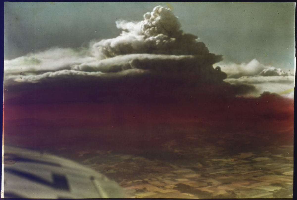
ALT Photo of one of the Tillamook Burn fires in August 1933 by Unknown author from an airplane featuring a dark black cloud made of smoke over a fire on the ground below.
19

Jun 12
Mini-pyrocumulus cloud in Mississippi? Cameras in Macon, MS show subtle smoke plume billowing into a cumulus cloud, and it lines up with a hotspot on the GOES Fire Temperature. How cool!

1
37

Jun 11
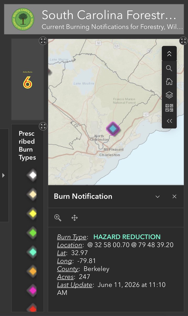
6/11/26 Thursday:
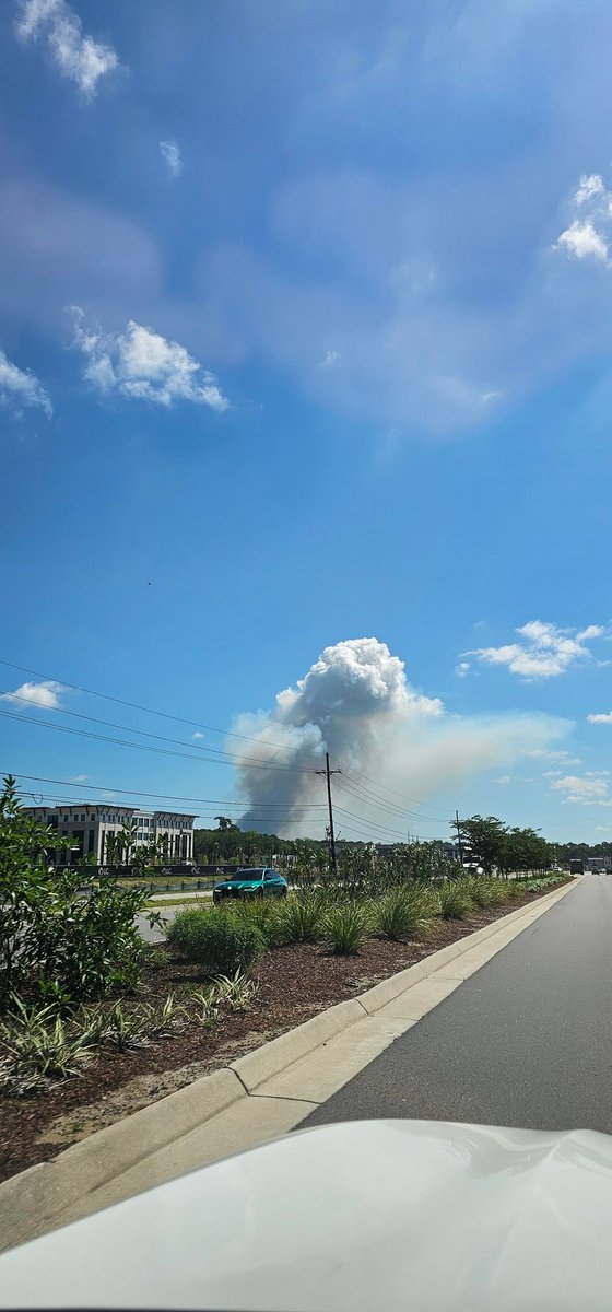
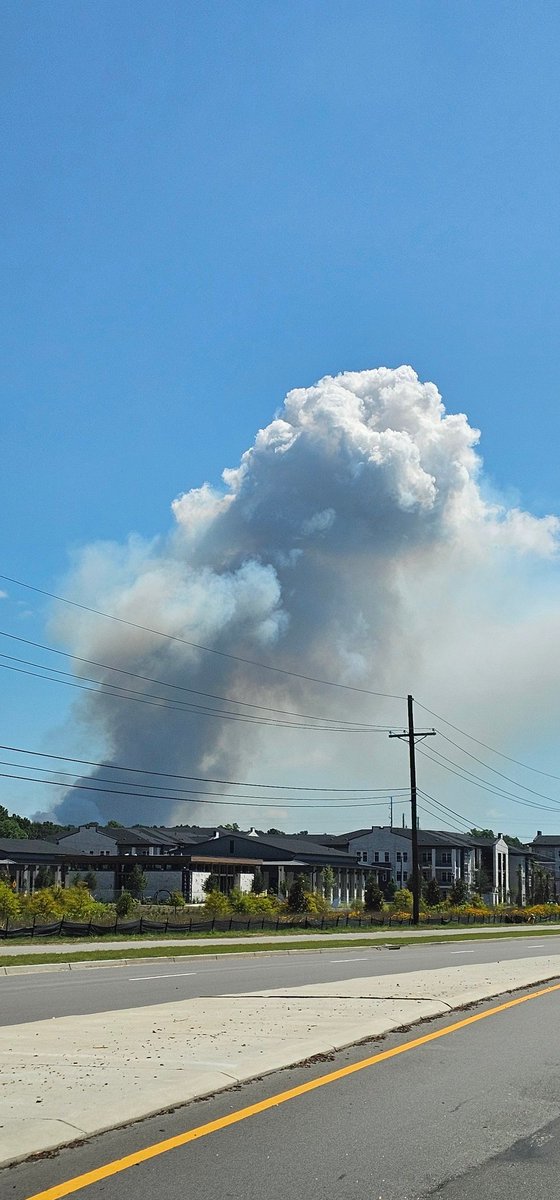
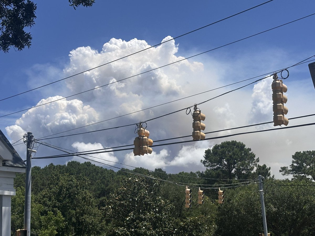
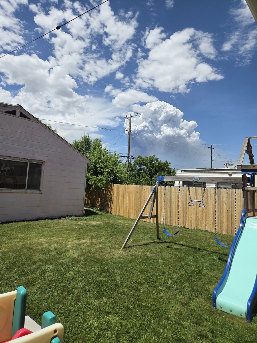
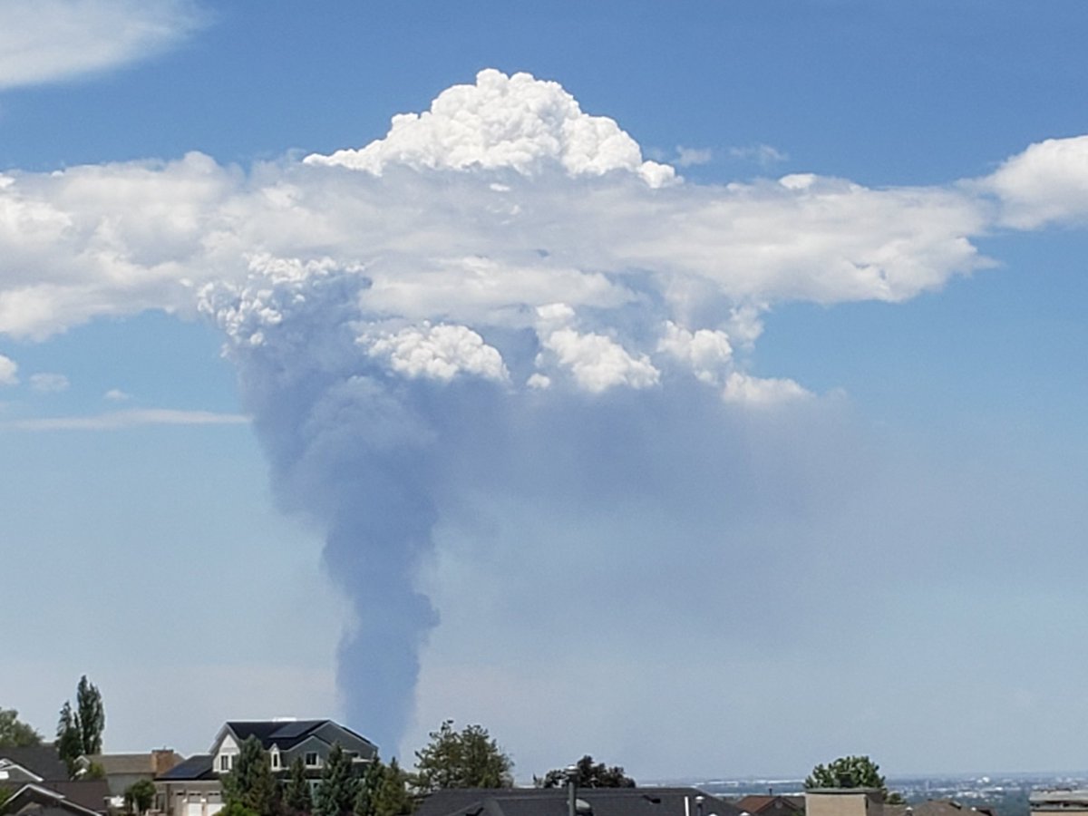
When it gets hot out and there are controlled burns like this one near Huger, SC, we can get a quickly rising vertical stack of superheated smoke that forms into a cloud-like structure. These are called "pyrocumulus clouds" and eventually dissipate, but they can look very ominous like a dangerous firestorm and if not controlled...can drop cinders/hot ash far away and create a dangerous wildfire. This one is an ongoing controlled burn that shot up vertically as inland thermal activity was already in lifting motion ahead of the sea breeze front.
First two pics are mine from Clements Ferry Rd in Wando, SC...and the last one is by Chris Copenhaven in Park West neighborhood in Mt Pleasant, SC.
3
1,076


Lux! (Guilty: 40 Counts of Cherishment) retweeted

Jun 10
Unfortunately, as expected, the #SouthForkFire in Nebraska is going big this afternoon. Exhibiting pyrocumulus and appears to have two distinct head fires moving eastward. #newx #nefire
1
4
20
1,081

1
589

Jun 9
Whoever thinks changing the weather across the globe and dispersing pyrocumulus cloud doesn't require at least multi-continental levels of force is being ridiculous.
19

Unlikely. Megafires of today create their own weather. The force of winds and pyrocumulus clouds prevent even legacy aircraft from doing their job.
1
1
50

Jun 6
☁️ حين تتحول السماء إلى محيط حي
أغرب السحب والظواهر السحابية التي قد تراها على كوكب الأرض
في معظم الأيام ننظر إلى السحب وكأنها مجرد خلفية للسماء…
لكن الحقيقة أن الغلاف الجوي يخفي مشاهد أقرب إلى الخيال العلمي والأفلام السينمائية.
فهناك سحب تبدو كأمواج بحر متجمدة، وأخرى كأنها صحون فضائية، وبعضها يظهر كجدار عملاق يبتلع الأفق بالكامل.
أما بعضها الآخر، فقد يخيف الناس فعلًا بسبب شكله الغريب والعنيف.
━━━━━━━━━━━━━━━
☁️ الماماتوس —
السحب التي تبدو وكأن السماء تنهار
تُعد سحب Mammatus من أشهر وأغرب السحب في العالم.
شكلها يشبه:
جيوبًا ضخمة متدلية
أو فقاعات معلقة أسفل السحابة
وغالبًا تظهر بعد العواصف الرعدية القوية.
ورغم أن منظرها مرعب، فإنها ليست دائمًا علامة على إعصار مباشر، لكنها ترتبط بأجواء جوية شديدة الاضطراب.
ويتكون هذا الشكل بسبب هبوط هواء بارد ورطب داخل السحابة بطريقة معقدة نسبيًا.
ولهذا السبب تستخدم كثيرًا في:
🎬 أفلام الكوارث
🎬 ومشاهد نهاية العالم
━━━━━━━━━━━━━━━
🌊 شوارع السحب —
طرق عملاقة في السماء
واحدة من أجمل الظواهر الجوية
هي ما يُعرف باسم: Cloud Streets
وهي سحب تصطف بخطوط طويلة ومتوازية لمسافات هائلة، حتى إنها تبدو من الطائرات وكأن السماء تحتوي على “طرق سحابية”.
تحدث هذه الظاهرة عندما يمر هواء بارد فوق سطح أكثر دفئًا، فتتشكل داخل الغلاف الجوي
“لفات هوائية” متوازية
فيظهر السحاب على شكل خطوط مستقيمة ومنظمة
وقد تمتد هذه الشوارع السحابية:
📏 لمئات الكيلومترات
ويستفيد منها أحيانًا: ✈️ الطيارون الشراعيون
لأنها تساعد على توليد تيارات هوائية صاعدة.
━━━━━━━━━━━━━━━
🛸 السحب العدسية —
السحب التي جعلت الناس يظنون أنهم رأوا أطباقًا فضائية
تُعرف باسم: Lenticular Clouds
وهي سحب ناعمة وعدسية الشكل، تظهر غالبًا فوق الجبال.
شكلها الغريب جعل كثيرين عبر التاريخ يعتقدون أنهم شاهدوا:
🛸 مركبات فضائية
لكنها في الحقيقة تتكون عندما يتحرك الهواء الرطب فوق الجبال بطريقة مستقرة، فتتشكل هذه الطبقات السحابية الثابتة.
ومن أشهر الأماكن التي تظهر فيها:
جبال الألب
جبال الأنديز
جبل فوجي في اليابان
━━━━━━━━━━━━━━━
🌪️ السحابة الرفّية —
الجدار القادم من العاصفة
تُعرف باسم: Shelf Cloud
وهي سحابة ضخمة ومنخفضة تتقدم أمام العواصف الرعدية.
وعندما تظهر، يشعر الناس وكأن جدارًا أسود يقترب منهم بسرعة هائلة.
وغالبًا تسبق:
رياحًا قوية
أمطارًا غزيرة
برقًا كثيفًا
ولهذا أصبحت من أشهر المشاهد المرتبطة بالعواصف العنيفة حول العالم.
━━━━━━━━━━━━━━━
🌊 السحب الموجية —
حين تتجمد أمواج البحر في السماء
من أندر الظواهر الجوية: Kelvin–Helmholtz Clouds
وتبدو كأن السماء تحولت إلى أمواج بحر متكسرة.
سببها اختلاف سرعة الرياح بين طبقتين جويتين، ما يصنع تموجات هوائية تظهر على شكل موجات مذهلة.
ويعتبرها كثير من خبراء الطقس: من أجمل الظواهر السحابية على الإطلاق.
━━━━━━━━━━━━━━━
⛈️ السحب الركامية المزنية —
مصانع العواصف العملاقة
هذه السحب هي المسؤولة عن:
⚡ البرق
⛈️ الرعد
🌪️ الأعاصير أحيانًا
وتُعرف باسم: Cumulonimbus
وهي من أضخم السحب على الأرض، إذ قد يصل ارتفاعها إلى: 📏 18 كيلومترًا
أي أنها قد تخترق معظم طبقات الغلاف الجوي السفلى.
━━━━━━━━━━━━━━━
🌌 السحب الليلية المضيئة —
سحب قريبة من الفضاء
تظهر أحيانًا بعد غروب الشمس بفترة طويلة، رغم أن السماء تكون مظلمة بالكامل.
وتُعرف باسم: Noctilucent Clouds
وهي سحب عالية جدًا تعكس ضوء الشمس من ارتفاعات قريبة من حدود الفضاء، لذلك تبدو وكأنها تتوهج ليلًا.
━━━━━━━━━━━━━━━
🔥 سحب الحرائق —
عندما تصنع النار غيومها الخاصة
في حرائق الغابات الضخمة أو الانفجارات البركانية، قد تتكون سحب خاصة
تُعرف باسم: Pyrocumulus
فالحرارة الشديدة تدفع الهواء والدخان للأعلى بقوة هائلة، فتتشكل سحب ضخمة قد تنتج برقًا وعواصف خاصة بها.
━━━━━━━━━━━━━━━
🌍 السماء أعقد مما نتصور
السحب ليست مجرد “ديكور” للسماء…
بل أنظمة فيزيائية هائلة تتحكم في:
المطر
الحرارة
العواصف
المناخ العالمي
وحتى حركة الطيران
وبعض التكوينات السحابية فوق المحيطات قد تمتد لمسافات أطول من دول كاملة.
ولهذا، فإن النظر إلى السماء أحيانًا…
يعني أنك تنظر إلى واحد من أعقد الأنظمة الطبيعية على كوكب الأرض.


1
14
809

Do you have an interesting cloud photo that you took to share 📷
These are pyrocumulus clouds from the Hermit's Peak Fire, in the setting sun of Northern New Mexico


19
1
59
1,691

RCP4.5 was never
favored •-_-• except
perhaps by we few,
the dispassionate
Always been about
SSP1 ecosocialism
Only 🌟 Thing that Climatologists have ever asked for 😖 and you would rather DI≡ with Pyrocumulus clouds horizon to horizon in SSP5-8.5
Than take the Bus 🚍
2
2
26

May 27
Salt Lake City pyrocumulus cloud. Should a fire really cause a full on thundercloud? Feels like another cause of geoengineering, smoke collecting on the particulates overhead, sometimes leading to their own weather systems.
5
12
32
1,022

May 26
Really cool look at pyrocumulus development over northern Utah yesterday.
The intense heat from the fire creates strong localized ascent, allowing the smoke plume to rise high enough for condensation and cloud development to occur. Pretty impressive vertical growth shown in this timelapse.

If you're on the Wasatch Front, you probably noticed a large pryocumulus cloud develop over a prescribed fire! Here's a timelapse of the plume development and a display of the instability in place over northern Utah #utwx
2
79

This was an impressive smoke column and pyrocumulus cloud over the Great Salt Lake marshes in Davis County this afternoon.
4
26
220
14,715

May 25
Pretty incredible timelapse from Bountiful today as pyrocumulus clouds rapidly formed above the prescribed burn near Farmington Bay. 🔥☁️
These clouds develop when intense heat from a fire forces air to rise quickly into the atmosphere — almost like a fire creating its own weather. You can really see the atmosphere come alive in this video.
🎥 Todd McKinley
14
23
276
39,395


May 25
Awesome Pyrocumulus clouds over the Great Salt Lake from invasive weed burning today. @NWSSaltLakeCity @ChaseThomason @KSL_Devan @KSL_Matt @JimCantore @DanPopeWeather @NWSSaltLakeCity @madithemet #utah

3
1
16
571

Pyrocumulus cloud, forming from a fire near the Great Salt Lake. Seen from southeast. @SLCScanner
1
3
560