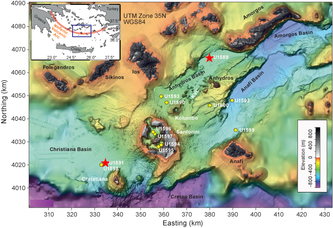
Filter
Exclude
Time range
-
Near
Frank Maiwald (or Maiwald; died July 4, 2024, age 61) Principal researcher and senior scientist at NASA’s JPL in Los Angeles. He managed Earth-observing and space instrumentation projects, including work on instruments like SBG-VSWIR and studies on cabin air for spaceflight and Jupiter’s oceans. He received multiple NASA awards; no cause of death or autopsy details were publicly released
1
7
196
... supervizor u Jet Propulsion Laboratory (JPL), radio je na naprednim senzorima (radiometrija, terahertz spektroskopija, orbitalni instrumenti poput SBG-VSWIR i AMR-C). Iznenada je umro u srpnju 2024. godine i uzrok smrti je nepoznat. • Anthony "Tony" Chavez - ... 🧵 (5/11)
1
2
56
7⃣Frank Maiwald (4 julio 2024) Trabajo en el Laboratorio de Propulsión a Chorro (JPL), donde su experiencia y liderazgo fueron fundamentales. Frank dirigió el desarrollo del instrumento SBG-VSWIR (Proporciona imágenes espectroscópicas globales para estudiar la biología y la geología de la superficie terrestre) y anteriormente había supervisado la entrega exitosa de dos instrumentos para el programa AMR-C. Entre sus funciones se incluía la supervisión de grupos técnicos y la contribución a diversos proyectos importantes como AMR/SWOT, COWVR, AMR/Jason 3 y HIFI. Las contribuciones académicas de Frank fueron ampliamente reconocidas, plasmadas en numerosas publicaciones y galardones, incluyendo varios premios prestigiosos del JPL y la NASA. Falleció en julio de 2024 a los 61 años en unas circunstancias desconocidas y de las que poco o casi nada se supo...
2
5
13
1,600
Replying to @root_rat
huuy....pues te faltan...te los añado: 7. Anthony Chavez 78 años, empleado jubilado del Laboratorio Nacional de Los Álamos, desapareció de su hogar en Los Álamos en mayo de 2025. Su automóvil seguía allí. Dentro, su billetera, llaves y cigarrillos quedaron sobre la mesa. Los detectives no encontraron signos de forcejeo, y los perros de cadáveres no hallaron nada. Nunca ha sido encontrado. 8. Frank Werner Maiwald Murió el 4 de julio de 2024, en Los Ángeles a los 61 años. Los registros públicos citados en el artículo lo describen como supervisor de un grupo técnico del Jet Propulsion Laboratory cuyo trabajo involucraba instrumentos avanzados de teledetección remota, incluyendo el programa SBG-VSWIR y otros sistemas de detección orbital con aplicaciones tanto civiles como potencialmente de defensa.
2
8
1,551
List of every name we have reported on. We are still investigating more and the list will likely expand. July 4, 2024. Frank Werner Maiwald, 61. JPL. Technical group supervisor. SBG-VSWIR and AMR-C programs. Dead. No cause disclosed. No institutional acknowledgment. May 5-8, 2025. Anthony Chavez, 78. LANL. Specific role undisclosed. Wallet, keys, cigarettes left. No cell phone. Missing. June 22, 2025. Monica Jacinto Reza, 60. JPL. AFRL-funded contractor. Inventor of Mondaloy. Vanished from Angeles National Forest. Missing. June 26, 2025. Melissa Casias, 53. DOE advisory board member connected to LANL. Both phones factory-reset. Staggering on surveillance footage. Missing. October 25, 2025. Jacob Prichard, 34. AFRL Sensors Directorate. Jaymee Prichard, 33. AFLCMC. 1st Lt. Jaime Gustitus, 25. AFRL 711th Human Performance Wing, TS/SCI. Dead. No motive determined. Being investigated by AFOSI. December 15, 2025. Nuno Loureiro, 47. MIT. Herman Feshbach Professor of Physics. Director of MIT Plasma Science and Fusion Center. LANL Ulam Distinguished Scholar. Shot in apartment foyer. Perpetrator planned for years and had burner phones. Dead. February 16, 2026. Carl Grillmair, 67. Caltech/IPAC. NEOWISE pipeline. NEO Surveyor instrument characterization. Shot on his porch. Killer's charges dismissed eleven days earlier. Dead. February 27, 2026. William Neil McCasland, 68. Former AFRL Commander. Phone, glasses, wearables left. Nobody witnessed departure. Missing. Background: Dallis Hardwick. AFRL Materials Directorate. Reza's mentor. Mondaloy co-inventor. Died of cancer 2014. No public acknowledgement of her death. No mention of her work in the obituary. Ten active. Eleven total. Nineteen months. Four states.
5
56
172
19,823
⚠️‼️🚨This is Becoming More Eerie by the Day As if these recent disappearances tied to aerospace and defense weren't concerning enough. Seriously, we may need an actual taskforce for this investigation. You aren't going to believe this. It gets weirder. I'm not kidding. A new report from @thesentinelnet is drawing fresh attention to what it says may be a larger pattern hidden in plain sight: a growing cluster of deaths and disappearances involving people tied to the defense, aerospace, and national laboratory ecosystem. The article adds two names to that expanding timeline, Frank Werner Maiwald and Anthony Chavez, while arguing that several cases previously treated as isolated may warrant closer scrutiny when viewed together. According to the report, Maiwald died on July 4, 2024, in Los Angeles at age 61. Public records cited in the piece describe him as a Jet Propulsion Laboratory technical group supervisor whose work involved advanced remote-sensing instruments, including the SBG-VSWIR program and other orbital sensing systems with both civilian and potential defense applications. The article emphasizes that no public cause of death was identified in his obituary and says there was little to no visible institutional acknowledgment of his passing. The second newly highlighted case is Anthony Chavez, a 78-year-old longtime Los Alamos National Laboratory employee who vanished in May 2025. The report says Chavez’s car was found at his home, while his wallet, keys, and cigarettes remained inside. Investigators reportedly found no sign of forced entry, no sign of a struggle, and no blood. Search dogs came up negative, his bank activity stopped, and he has not been found. The article notes that his exact role at LANL has not yet been confirmed, but argues that his disappearance belongs in the same broader conversation as other New Mexico corridor cases. The article also revisits the disappearance of former Air Force Research Laboratory commander William McCasland. Its central point is that the widely repeated narrative that McCasland “left on foot” appears, at least based on the reporting cited here, to be more assumption than verified fact. The report says a repairman saw him at home that morning, and when his wife returned a little over an hour later, he was gone. It further notes that no confirmed surveillance footage, witness sighting, or other evidence has publicly established how he left or where he went. From there, the piece lays out what it calls a shared physical signature across multiple disappearances: personal effects left behind, negative searches, no confirmed direction of travel, and no recovery of remains. It specifically groups Chavez, Melissa Casias, Monica Reza, and McCasland into that pattern, while stopping short of claiming a proven common cause. That distinction matters. The report does not present definitive proof of conspiracy. Instead, it argues that the similarities are substantial enough that authorities should examine the cases as a pattern rather than as disconnected events. The article then broadens its scope further by connecting this line of inquiry to gaps in detection infrastructure. It highlights the earlier killing of Carl Grillmair, whose work involved the NEOWISE data pipeline and characterization efforts tied to NEO Surveyor, a mission intended to improve detection of potentially hazardous near-Earth objects. The report is explicit that it is not asserting a direct link between these cases and recent fireball or impact concerns. Its argument is narrower, but still provocative: that the people connected to sensitive scientific and technical systems keep surfacing in troubling circumstances, and that someone with real investigative authority should now be looking at the full list as a full list. #ufox #ufotwitter Full credit goes to @thesentinelnet for this intel. Good work my friend.
41
279
885
35,637
$PL has surged with almost 500% in 2025. I'll explain why it has performed so well and which key milestones Planet reached in 2025. 1. Data Breakthroughs: Planet significantly upgraded the eyes of its fleet to provide more precise information. The Tanager Hyperspectral Satellite now captures the full light spectrum (VSWIR), allowing users to identify the exact chemical cause of a problem, such as specific gas emissions, rather than just seeing visual changes. Planet also sharpened its Planetary Variables, boosting Crop Biomass resolution to 3 meters, Soil Water and Land Surface Temperature to 20 meters, providing 25 times the clarity for soil and thermal analysis. 2. Platform & Workflow Optimization: The focus was on making geospatial data easier to manage without needing massive local storage. Planet streamlined its platform by consolidating tools like Sentinel Hub into a single, unified experience at insight.planet. They also focused on cloud-native GIS workflows, updating the ArcGIS Pro Add-in so professionals can stream imagery instantly and manage data in the cloud without the burden of downloading massive local files. Through a partnership with SkyFi, the company introduced Planet Select, a flexible pay-as-you-go portal for on-demand access to high-resolution SkySat imagery. 3. Automated AI solutions: New AI-driven tools were launched to handle data at a massive scale. Planet introduced machine learning solutions like Global Aircraft Detection, which monitors thousands of airfields daily to identify trends and anomalies. For the agricultural sector, the new Planet Area Monitoring Service (AMS) now automates compliance and verification across millions of hectares using a simple traffic light system. This automated approach replaces slow, manual field inspections with objective, field-level signals, significantly reducing costs and accelerating impact for geospatial professionals worldwide. 4. Ambitious Projects: Planet entered into two landmark partnerships that define the future of space-based infrastructure. Project Suncatcher is a research collaboration with $GOOGL. Planet is helping to build prototype satellites designed to host AI data centers in orbit, leveraging near-constant solar power to run massive machine learning workloads in space. $PL signed a massive $230 million agreement with Sky Perfect JSAT to build and launch a dedicated low-Earth orbit constellation using Planet’s next-generation Pelican satellites. This partnership marks a major move into the space intelligence and defense markets, providing high-resolution, 30cm-class imagery to support national security and disaster prevention initiatives.
2
14
699
탄소세 내러티브의 완성과 유일한 해자: 검증 가능한 동시성 1. 탄소세 내러티브의 핵심: '검증 가능한 데이터'탄소세와 Scope 3(공급망 전체 배출량) 감시의 원리는 간단하다. * 1. 위성으로 찍는 탄소세(Carbon Tax)의 핵심은 정치적 선언이 아니라, 징수 가능한 데이터의 존재 유무다. 탄소세 내러티브가 실현되는 원리는 간단하다. * 2. 배출량을 산출하여 과세를 하거나 크레딧을 발행한다. 이 두 가지만 충족하면 내러티브는 현실이 된다. 개별적 관점에서 보면 플래닛도, 블랙스카이도 가능해 보인다. 하지만 '감사(Audit)'의 영역으로 들어가면 이야기가 달라진다. 이들은 '초분광 데이터'와 '고해상도 식별 데이터'의 동시성을 갖추지 못했기 때문이다. ----- ** 무엇을 찍어야 하는가? (Scope 3 감시의 본질) 탄소세의 방향은 결국 Scope 3(공급망 전체 배출량) 모니터링이다. 여기서 핵심은 단순히 건물을 찍는 게 아니라, 그 건물이 내뿜는 '화학적 진실'을 찍는 것이다. 이를 위해선 초분광(HSI)과 다중분광(MSI)의 결합이 필수적이다. - 보이지 않는 연기 (제조/물류): 눈에 보이지 않는 이산화질소(NO2)를 찾아내야 한다. 저렴한 VNIR(400-800nm) 대역의 초분광 센서는 이를 위한 가장 효율적인 '추적자(Tracer)'다. - 가짜 녹색 (탄소 흡수원): 산림 벌채나 경작지 변화뿐만 아니라, 그린워싱(위장)을 뚫고 실제 식생의 탄소 흡수 효율(건강도)을 정밀 타격해야 한다. - 정체불명의 더미 (원자재): 항구에 쌓인 검은 가루가 흙인지, 석탄인지 '성분'을 밝혀내야 한다. ----- ** 플래닛(Planet)의 딜레마: Tip-and-Cue의 한계 플래닛에는 태너저(Tanager) 위성이 있다. 400개가 넘는 밴드(VSWIR)로 아주 정밀한 측정이 가능하다. 하지만 이것이 스코프 3 감시에서는 독이 된다. - 좁은 시야: 분광 해상도가 높아지면 관측 폭(Swath)은 줄어든다 (현재 ~18km). 광역 감시가 불가능하다. - 깨진 동시성: 플래닛은 펠리컨(일반)이 먼저 찾고, 태너저(초분광)가 나중에 가서 찍는 'Tip-and-Cue' 방식을 쓴다. ---> 이 시간차(Time Lag) 동안 연기는 흩어지고 트럭은 이동한다. ---> 결과: "10시의 트럭과 12시의 가스"를 매칭한 데이터는 법적 증거로써 효력을 잃는다. 징세의 근거가 될 수 없다. - 비용의 이중고: 고가의 태너저 위성과 펠리컨 위성을 따로 운용해야 하므로, 고객에게 전가되는 비용 구조가 비효율적이다. ----- ** 세틀로직(Satellogic)의 해자: 완벽한 동시성과 가성비 그럼 세틀로직은 어떤가? 고해상도(70cm) 다중분광 초분광(29밴드)이 단 하나의 위성(NewSat Mark V)에 합쳐져 있다. - 데이터의 무결성: 모든 데이터는 0.1초의 오차도 없는 '같은 시각'을 가리킨다. 즉, "저 트럭이 저 가스를 뿜었다"는 사실을 입증(Verify)할 수 있다. 이것이 탄소세 징수의 핵심인 '데이터 동시성'이다. - 압도적 가성비와 커버리지: ---> 비싼 SWIR 대신 VNIR(400-800nm) 초분광을 채택하여, 저렴한 CMOS 센서로 위성 단가를 낮췄다. ---> 경쟁사(Tanager ~18km) 대비 몇 배 이상 넓은 약 125~145km의 고해상도 관측 폭(Swath)을 가진다. ---> 현재 운용 위성은 22기 3(예정, 커미셔닝 단계)로 특정 지역의 재방문은 최대5회까지 가능하다. ----- ** 기술적 해자: 특허와 수직계열화 이것이 가능한 이유는 단순한 아이디어가 아니라 특허 기술 덕분이다. - 관련 특허 (US9813601B2): 단일 망원경으로 들어온 빛을 빔 스플리터(Beam Splitter)로 쪼개어, 시차 없이 고해상도 센서와 초분광 센서로 동시에 보내는 기술이다. 다른 경쟁사(Pixxel 등)는 초분광 해상도는 좋지만 공간 해상도가 5m급으로 낮아 개별 트럭이나 시설 식별이 불가능하다. 반면, 세틀로직은 '식별(1m 이하)'과 '성분 분석(초분광)'을 동시에 수행하는 유일한 양산형 모델이다. ----- 결론 탄소세 내러티브의 본질은 "누가 가장 싸고 빠르고 정확하게, '반박 불가능한 증거'를 들이밀 수 있는가?"이다. 데이터가 저렴하면서(CMOS), 스코프 3 목적(산업/물류/식생)에 딱 맞게 설계되었고, 넓은 Swath와 촘촘한 위성망을 통해 '동시성'을 보장하는 것은 현재 세틀로직이 압도적이다. 탄소세의 배경과 기술적 디테일(동시성, 파장 대역의 경제성)을 정확히 이해하지 못하면 모든 위성 회사가 비슷해 보일 것이다. 하지만 징세와 감사의 관점에서 보면, 승자는 이미 정해져 있다.
저도 흠... 부분적인 스코프3 참여는 가능하지만 전체 네러티브를 담기엔 기술에 한계가 있죠.
8
45
1,460
New publication! "Data report: visible to shortwave infrared (VSWIR) spectroscopic scanning" published 12/11/25 in #IODP Proceedings Volume 398: doi.org/10.14379/iodp.proc.3… #JRSO #Exp398 #NSFfunded @TheJR @NSF
3
6
1,122
And for those curious: NASA missions at risk from FY2026 budget cuts: Landsat Next, AOS-Storm, AOS-Sky, SBG-VSWIR, SBG-TIR, DSCOVR, SAGE III, Terra, Aqua, Aura, Mars Sample Return, DAVINCI, VERITAS, EnVision, VIPER, New Horizons, OSIRIS-APEX, Juno, Mars Odyssey, Mars Express, MAVEN, Chandra, Fermi, LISA, ULTRASAT, PhysCOS, Euclid, XRISM, Ariel, COSI, Multi-Slit Solar Explorer, IMAP, HelioSwarm, Wind, MMS, Hinode, TIMED, GOLD, IRIS, THEMIS, ACE, IBEX, AIM
15
5
135
24,382
Replying to @SpceEnthusiast
NASA missions at risk from FY2026 budget cuts: Landsat Next, AOS-Storm, AOS-Sky, SBG-VSWIR, SBG-TIR, DSCOVR, SAGE III, Terra, Aqua, Aura, Mars Sample Return, DAVINCI, VERITAS, EnVision, VIPER, New Horizons, OSIRIS-APEX, Juno, Mars Odyssey, Mars Express, MAVEN, Chandra, Fermi, LISA, ULTRASAT, PhysCOS, Euclid, XRISM, Ariel, COSI, Multi-Slit Solar Explorer, IMAP, HelioSwarm, Wind, MMS, Hinode, TIMED, GOLD, IRIS, THEMIS, ACE, IBEX, AIM
1
10
790
Вражаючі піщані дюни пустелі Алгодонес у Каліфорнії допомогли дослідникам з Техаського університету A&M створити першу базу даних складних дюн на Марсі. Їхня висота коливається від приблизно 1,8 до 122 метрів. Супутникові знімки та дані з безпілотника показали, що ці дюни пересуваються зі швидкістю близько 0,61 м на рік — удвічі повільніше, ніж дюни в Сахарі. Це пояснюється розрідженою марсіанською атмосферою: тиск на Марсі становить лише 0,6 % від земного. Найсильніші потоки піску зафіксовано у регіонах Syrtis Major, Hellespontus Montes та North Polar Erg, де переміщення дюн може змінити ландшафт за лічені роки. Для визначення складу піску команда застосувала спектроскопію у діапазоні видимого та короткохвильового інфрачервоного випромінювання (VSWIR), що дозволяє розкрити спектральні характеристики мінералів. Алгоритм MICA, розроблений USGS, підтвердив: яскраві пилові басейни швидше прогріваються, що сприяє активнішому руху дюн. Польові вимірювання проводилися у листопаді 2022 року, і отримані дані підтверджують, що марсіанські дюни мають суттєву схожість з тими, які ми бачимо на Землі. Результати дослідження допомагають удосконалити моделі руху піску та покращують наше розуміння марсіанського середовища, що є важливим фактором для планування майбутніх космічних місій.
1
4
86
2,220
NASA’s FY26 budget proposes major cuts to Earth Science programs: $1.03B requested, down ~52% from FY24 levels ($2.14B). Some highlights from the budget document: ➡️ Landsat Next restructured: The original plan for 3-satellite constellation is cancelled due to cost; NASA will now explore lower-cost commercial and hybrid alternatives to maintain Landsat continuity. ➡️ Several missions cancelled, deferred, or concluding: AOS-Storm/Sky and SBG-VSWIR/TIR (Decadal Survey priorities) removed from near-term Earth System Observatory plans; Terra, Aqua, Aura and DSCOVR reaching end of operations after decades in orbit. ➡️ Impacts on Applied Science: Many applied programs reduced or cut, with stronger emphasis on developing tools, platforms, and models to help end-users apply NASA Earth Science data for decision-making. Bottom line: Big shifts ahead for the global Earth observation sector, raising important questions such as: - What role will commercial EO companies play in filling these gaps - how does this affect their long-term roadmaps? - How will decadal science priorities evolve with reduced NASA budget - maybe a bigger role for international partners? - As NASA potentially shifts toward supporting end-users through science applications, how will this reshape the rest of the EO ecosystem? nasa.gov/wp-content/uploads/…
4
21
4,258
31 May 2025
(続き) ・SLS Block 1B能力向上:終了 ・Artemis III以降のSpace Launch System (SLS) および Orion 宇宙船:段階的廃止 ・AOS Storm、AOS-Sky、SBG TIR およびVSWIR ミッション:検討を継続しない ・Sentinel-6C、CRISTAL、Luce、PMMパートナーミッション:貢献を中止 (続く)
1
6
4
956
New VSWIR Imaging and Thermal Applications, Learning, and Science (VITALS) repository provides tutorials to work with imaging spectroscopy data, thermal infrared data, and other products from the EMIT and ECOSTRESS missions. #OpenScience Access: go.nasa.gov/48hJl2K
16
68
4,120
Landsat Next will collect data in 26 spectral bands: 21 visible to shortwave infrared (VSWIR) and 5 thermal infrared (TIR) bands all with enhanced spatial resolutions. Learn more about the future of #Landsat: go.nasa.gov/3TkcapS
2
11
1,097