
The #WeatherModels had a foot of #snow followed by a #PolarBlast forecast for #Colorado
Is it #AGW Spring yet?
snowbrains.com/snowbrains-fo…
2
1
2
43

🚨🌪️ The 12z NAM is showing an explosive severe weather environment developing this afternoon along the outflow boundary across northern Missouri into southern Iowa! 🌩️⚡️ Any supercell that can latch onto the boundary could rapidly intensify and become capable of producing tornadoes, very large hail, and damaging winds. Strong instability, backed surface winds, rich moisture, and increasing wind shear all appear to be coming together in this corridor. 👀📡
This is definitely an area to watch closely later today for isolated tornadic supercells if storms can remain discrete before growing upscale. We’ll be targeting the region and monitoring trends carefully. Stay tuned for live updates and storm chase coverage! 🚗🌪️⚡️
#SevereWeather #Tornado #StormChasing #Missouri #Iowa #Supercell #Weather #MidwestWeather #TornadoWarning #SevereStorms #StormChaser #WeatherUpdate #NAM #WeatherModels #LiveStormChasing #NorthernMissouri #SouthernIowa #MidwestStorms 🌪️⚡️

5
15
1,136

May 12
Weather modeling always seem to be a conundrum. We will have to figure it out the best we can in order to be successfully. #weather #weathermodels #wxtwitter
3
146
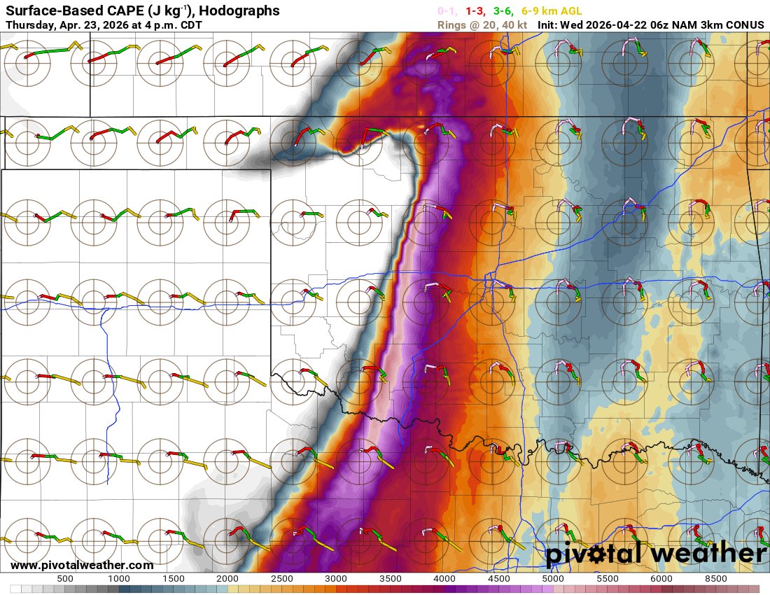
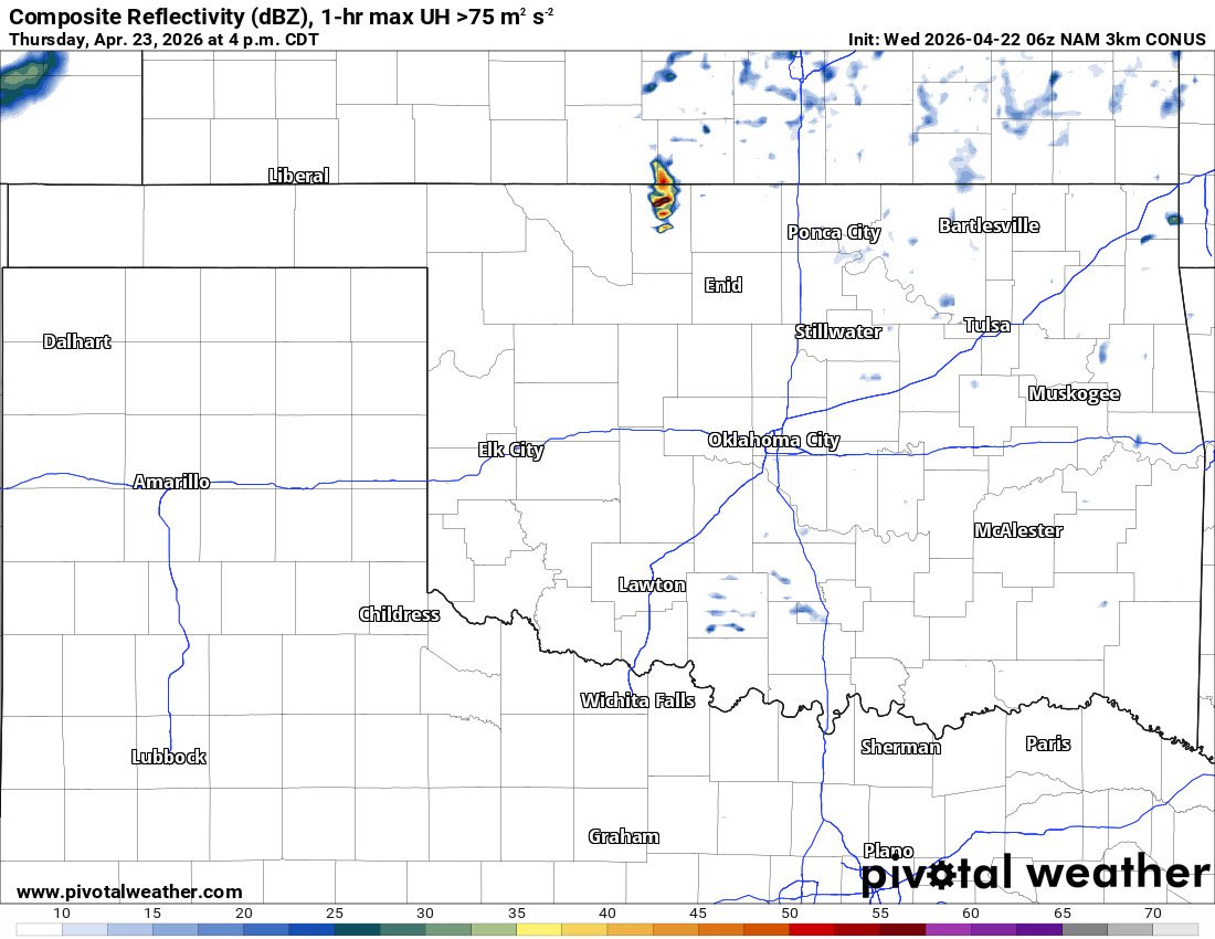
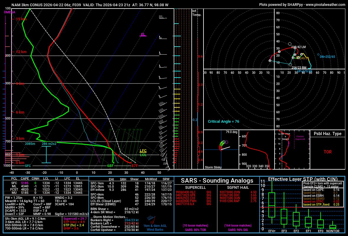
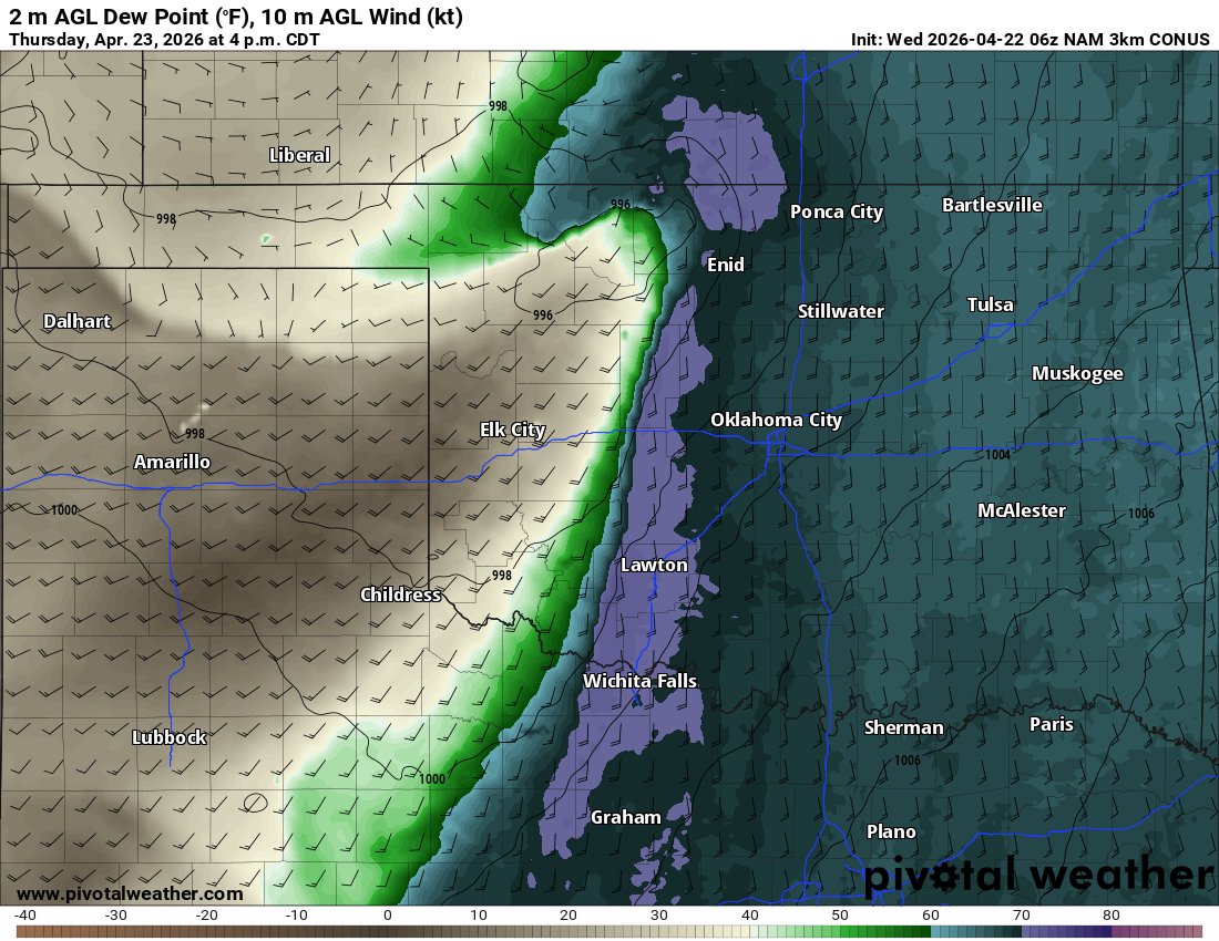
The NAM3KM model is highlighting a very intriguing but conditional setup across southern Kansas for Thursday.
⚡A dryline bulge intersecting with a surface low could allow very dry air to punch into a rich, moist environment — a classic setup that can locally weaken the cap and spark explosive storm development. 🌡️💨
👉 Key factors:
• 🌵 Dryline bulge = focused storm initiation zone
• 💧 High moisture (dewpoints 60s ) fueling instability
• 🌪️ Strong wind shear supportive of rotating supercells
• 🔥 Cap strength = main limiting factor
(storm coverage uncertain)📊 Forecast guidance suggests that if storms can break through the cap, any discrete supercell that forms and moves off the boundary could become a strong tornado producer. However, this setup is high-risk / high-reward
— Storms may be isolated or fail to develop at all if the cap holds. Other models like the HRRR model and GFS model have shown inconsistent signals, but there’s a slow trend toward supporting the NAM solution, which has remained relatively consistent.
⚠️ Bottom line:
A conditional but potentially dangerous setup in southern KS Thursday — if storms fire, they could quickly become tornadic, but confidence in storm initiation is still uncertain.🌪️🔥⚡
#KSwx #SevereWeather #Dryline #StormChasing #TornadoSetup #WeatherModels #Supercells #MidwestWeather #StormSeason #WxTwitter
1
4
46
6,267

Mar 30
👀 Evolución de los centros de acción durante la Semana Santa en España. Modelo GFS (weathermodels)
6
454

Mar 27
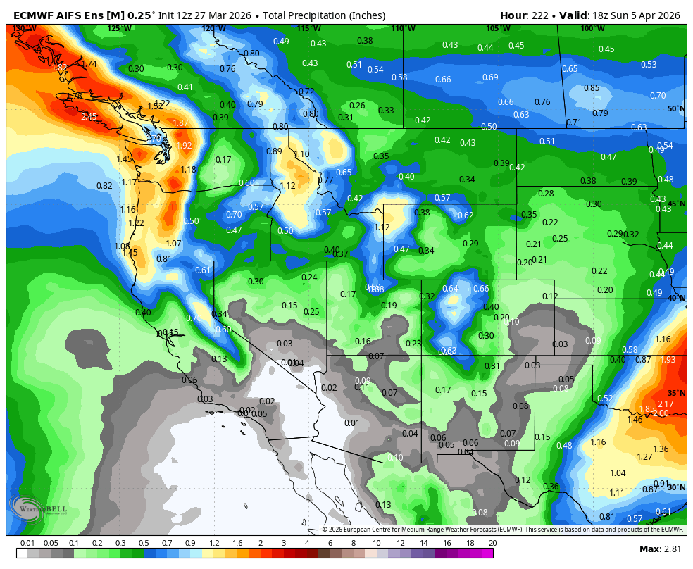
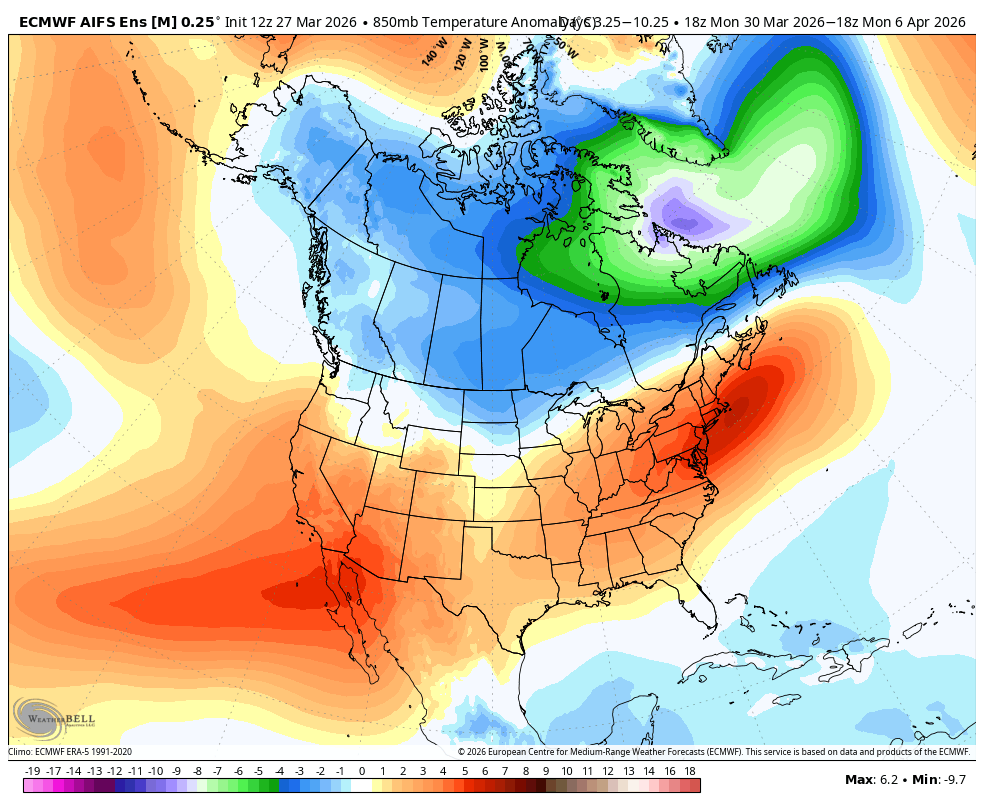
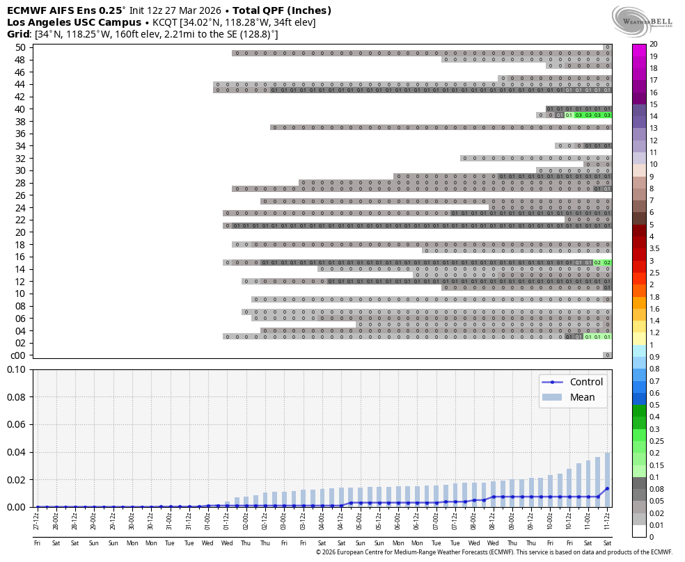
Followers — quick update on the “big pattern change” everyone was hyping. Let’s just call it what it is: Nothingburger!!!! Model trends continue to come in LOWER and LOWER for #SoCal precipitation, it is there is anything at all! Below is my AI wx discussion with some thoughts at the end of this discussion
Discussion —
Over the past several runs, we’ve seen a consistent signal:
→ QPF totals trending down
→ Trough amplitude weakening
→ Energy shearing east instead of digging
→ Ridge resistance still present over the Eastern Pacific
In other words… the system is losing its teeth as we get closer in time. In fact, I think we are going from one warm pattern to another. I think we have seen this more often than not in #California this season. It is just not our winter folks!!
The original idea of a clean undercut of the ridge with a sustained moisture tap has not materialized. Instead, we’re looking at a more progressive, positively tilted, lower-amplitude trough that struggles to overcome the background ridge states and go up and over #California.
Translation:
This is not a high-impact storm cycle for #SoCal at all!
Before are my AI Models images for temps, precp and meteograms....And look — I said this days ago..... I wasn’t impressed with the setup earlier this week. The signal just wasn’t there for a meaningful precipitation event in #socal, and it is getting worse every run.
And for that take?
I got called:
→ “Hostile”
→ “Doesn’t know what he’s talking about”
→ “Negative”
The hits keep on coming....LOL. Bring them on!!!!
Now here we are folks, watching the exact trend I talked about play out in real time, and I will still get shamed. Keep it coming folks!!!! Most of the talking weather heads on this medium chase long-range fantasy runs from deterministic GFS/EU1 models. They don't watch trend evolution, use ensemble means, AI ENS runs, and pay attention to how the pattern behaves as it compresses in time. Personally, I have no idea what a lot of them look at, but here we are, and I am the bad guy!
What’s actually happening synoptically:
→ The ridge never fully breaks down — it gets nudged, not displaced
→ The upper low weakens as it approaches the coast
→ Jet support is marginal and poorly aligned
→ Moisture transport is limited — no real atmospheric river connection of any sort.
→ Result: light, scattered precip at best for #SoCal, and even that is dwindling.
Northern/Central California? Sure — they’ll do better.
But down in #socal - This is looking more like a glorified marine layer enhancement event with some light rain mixed in...maybe. Even the light rain part is TBD.
Mountains still getting crushed
Nothing has changed here — in fact, it’s getting worse.
We’re still running:
→ Elevated snow levels
→ Warm overnight lows
→ Poor refreeze conditions
Resorts are hanging on by a thread trying to make it to Easter… but that’s looking shaky.
From what I’m hearing:
→ Deer Valley Resort — closing Sunday (yep… that was my trip 😑)
→ Park City Mountain Resort — likely next domino to fall
→ Widespread coverage issues across the Wasatch and Sierra, and Rockies. Steamboat is closing or is closed now.
→ Dirt showing up everywhere
Depressing, but that is where we are with this winter pattern. Never seen such sustained heat/warmth for such a duration like this season! It feels like mid-to-late April conditions… if not worse.
I was set to head out Sunday, but with closures accelerating and finalized, that plan is done. DOA!
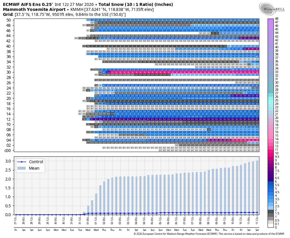
For those of you that have asked me if the pending snow for next week in NorCal and the Sierra and Utah, will make a difference in the snow pack, the answer is no. If you look at the resorts, in Utah now, they are getting nuked, as I have discussed with you how much of the snow pack they are losing with 60 degrees per day. Now, Alta and Snowbird, due to their location and elevation usually are able to sustain their snow pack the longest. They might benefit, but the other resorts by this time next week will probably close. Snow Basin is closed, Deer Valley is closed. Park City is rumored to be closed on Sunday. In any case, Alta and Snowbird will probably be the only ones open before they get snow next week. TBD at this point.
As for #california, I have posted the Meteograms for snow in Mammoth thru the extended. Not much going on folks, so again, that is where we are. I will update this on Sunday night and see if the models have changed, but frankly based on the trends and the atmospheric pattern out west this season, every day gets drier and warmer next week. Hence why I declared winter was over 2 weeks ago.
More on Sunday and if you have questions of any sort, let me know.
Stay cool!
#SoCalWeather #CaliforniaWeather #WestCoastWeather #ENSO #ElNino #SierraNevada #Wasatch #WeatherModels #Meteorology #SkiSeason #SpringPattern #cawx
21
5
66
9,677

Mar 6
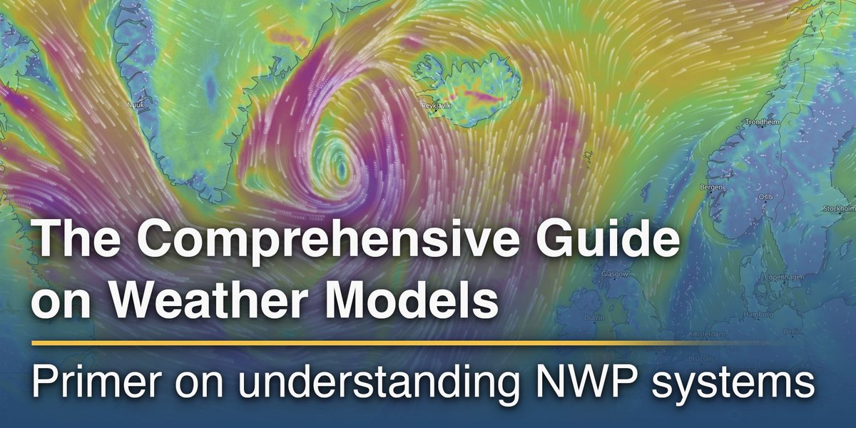
🔎🌍 New Article Series: Understanding Weather Models (Part 1)
Every weather forecast – whether for tomorrow’s rain or next week’s temperature trend – is powered by an extraordinary scientific system working behind the scenes: numerical weather prediction (NWP) models.
In the first part of our new series, we explore the foundations of modern weather forecasting: how global observations, physics, advanced mathematics and supercomputing come together to simulate the atmosphere and produce the forecasts we rely on every day.
From the role of satellites and data assimilation to model grids, parameterisation and the limits of predictability, this article offers a clear introduction to the science behind weather models.
👉 Read the full article here: meteoblue.com/en/blog/articl…
In Part 2, we will dive deeper into global and regional models, ensemble forecasting, probabilistic predictions and emerging hybrid modelling approaches.
#WeatherModels #NumericalWeatherPrediction #Meteorology #meteoblue
1
6
363
Watching that triple point near the meso low in SE Kansas tomorrow 👀 If storms can break the cap there, discrete supercells look possible — and models are signaling tornado potential 🌪️⚡️ Cap strength will be the key player.
#KansasWx #SevereWeather #TriplePoint #MesoLow #Supercells #TornadoPotential #StormChasing #PlainsWx #WeatherModels #WxTwitter 🌩️
2
563
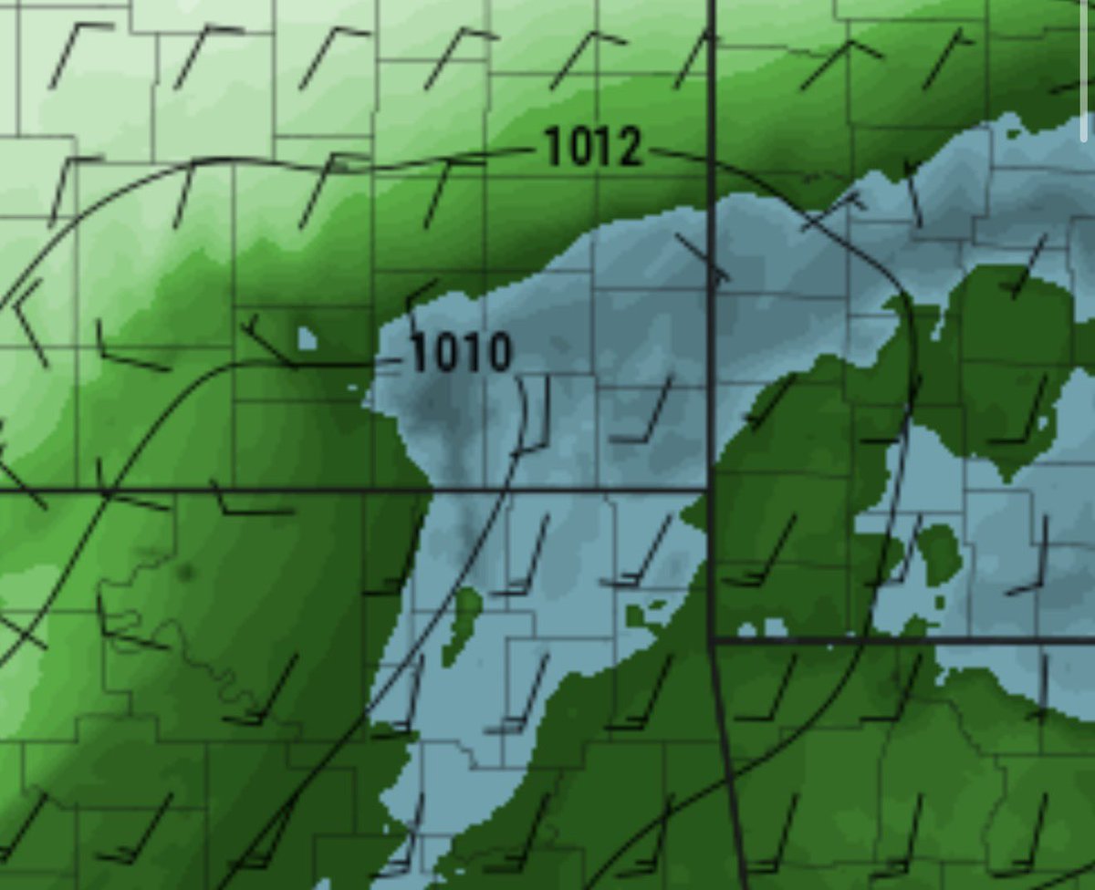
🌪️ The NAM is now hinting at severe potential Wednesday across Illinois. The key? Tuesday’s low over eastern Kansas needs to stay north and avoid getting shoved south by the cold front — something a few models suggest could happen.
Meanwhile, the RAP and FV3 keep the low over central/eastern Kansas Tuesday before it tracks east, potentially setting up a favorable triple point in Illinois on Wednesday. 👀
With decent 925–700mb winds in place, this setup is worth watching closely.
#ILwx #SevereWeather #MidwestWeather #WeatherModels #NAM #RAP #FV3 #StormChasing #TriplePoint #WxTwitter 🌩️
1
11
893
Feb 27
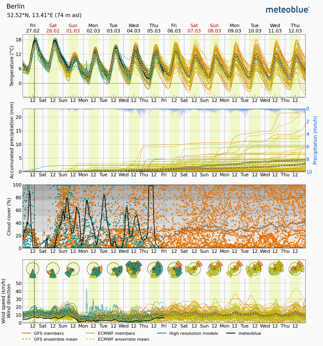
📈🌍 Understanding Weather with Ensemble Forecasting
Even with today’s high-resolution weather models, small variations in the initial state of the atmosphere can lead to very different outcomes over the coming days. This is not a flaw – it is simply a reflection of the complex and dynamic nature of the atmosphere. The way clouds form, winds shift, or humidity changes in one location can cascade into significantly different weather patterns elsewhere, making each forecast a balance of probabilities rather than a single certainty.
To address this, meteoblue applies ensemble forecasting, running multiple simulations with slightly different initial conditions. Each ensemble helps to account for:
➡️ Incomplete or imperfect observational data used to initialise the forecast
➡️ Sensitivity of the atmosphere to tiny differences in starting conditions
➡️ Model limitations, such as grid spacing or simplified physical processes
By comparing the results of multiple models, we can estimate the likelihood of different weather scenarios, from temperature and precipitation to wind patterns and cloud cover. This approach not only improves forecast reliability but also highlights the range of possible outcomes, helping businesses, cities, and individuals make better-informed decisions.
High-resolution ensembles allow us to detect subtle local phenomena – for example, a micro-scale thunderstorm that only develops in one part of a city, or short-term temperature changes in complex terrain – which traditional single-model forecasts might miss. The result is a forecast that is not just a prediction, but a decision-making tool, showing the probability of events and helping users plan with confidence even in the face of uncertainty.
👉 Check the ensemble weather forecast for your location here: meteoblue.com/en/weather/for…
#WeatherForecast #EnsembleForecasting #WeatherModels #meteoblue
1
7
377
🌩️ Severe Weather Potential for Thursday in Illinois 🌪️
The GFS and EURO models are coming into better agreement on the position of the surface low and where stronger moisture return could set up across Illinois. If enough low-level moisture and instability develop — including adequate 0–3 km CAPE and surface-based CAPE — we could see a low-CAPE, high-shear environment supportive of low-topped supercells.
While this setup would be conditional, it cannot be ruled out at this time. This may be the first legitimate severe weather setup of the year for Illinois if trends continue.
More details to come as we analyze higher-resolution data. Stay tuned! 📡🔥
#IllinoisWeather #SevereWeather #LowToppedSupercells #WeatherModels #ILwx #Cilwx #StormSeason #MidwestWeather #StayWeatherAware


20
1,520

Feb 12
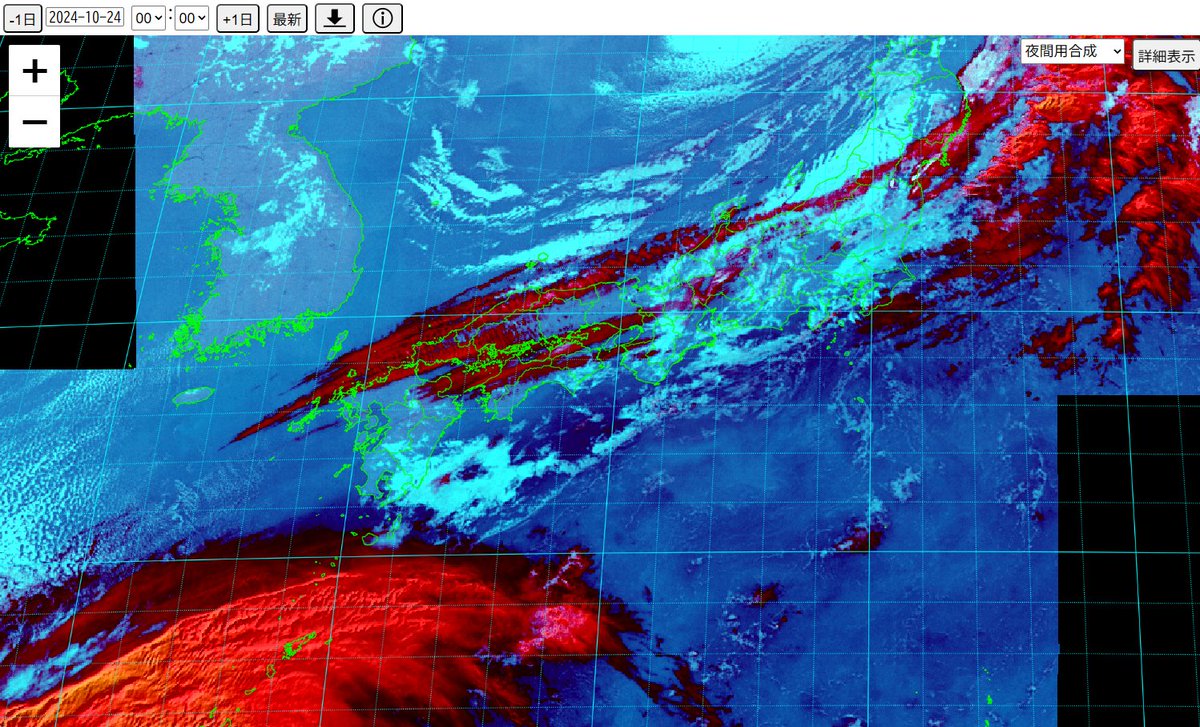
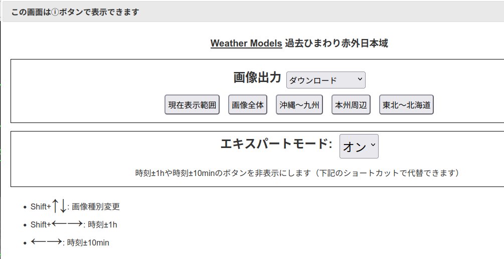
WeatherModels様の「過去ひまわり赤外日本域」は当方のPCのMicrosoft Edgeで表示できない状態(2月12日11時25分時点)ですが、Google Chromeでは表示できました。
Feb 11

ひまわり日本域赤外のページを2024年10月24日以降自由に遡れるようにした。iアイコンで出てくるダイアログでエキスパートモードをオンにすると、ショートカット機能で代替できる一部のボタンを非表示にして操作領域をコンパクトにできる。
weather-models.info/latest/h…
1
3
1,025
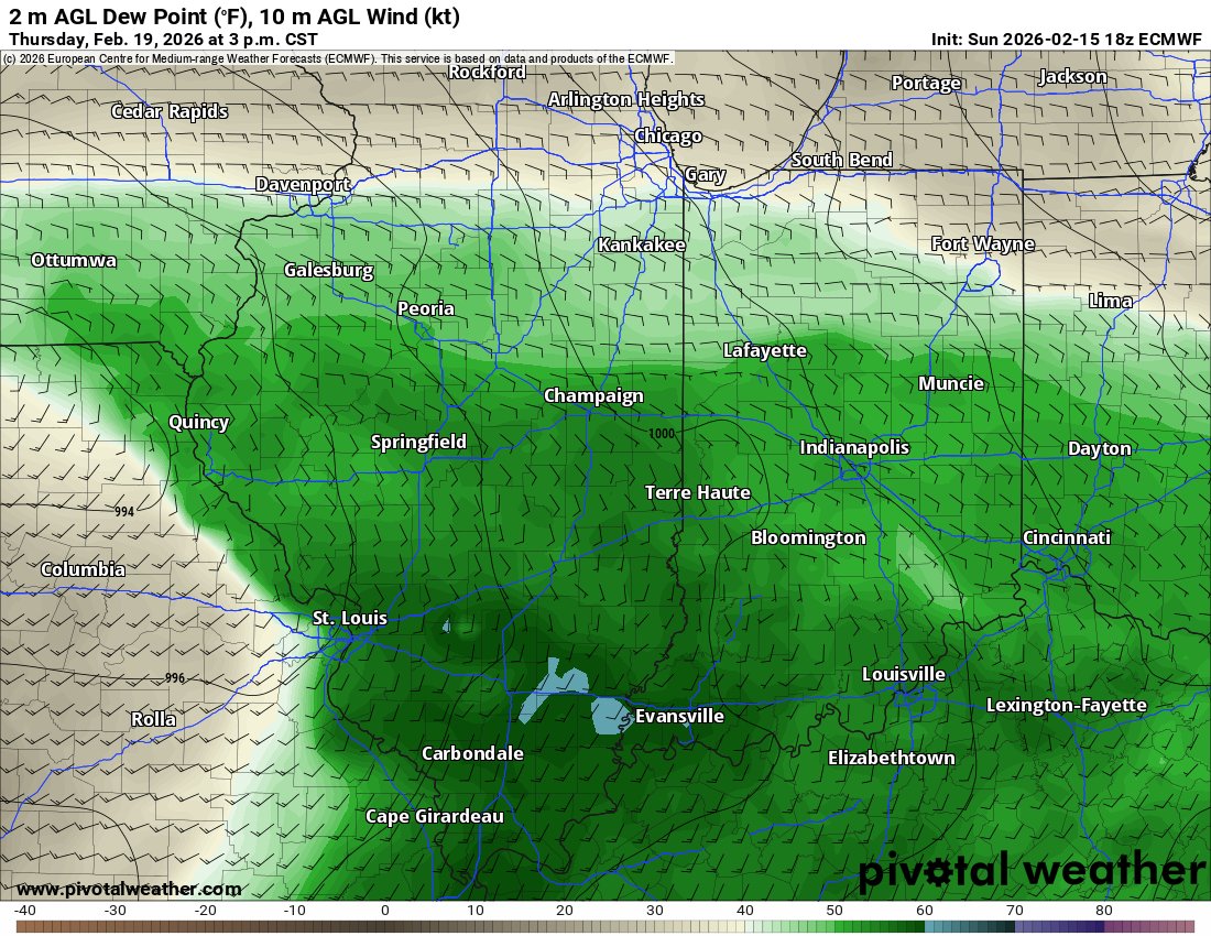
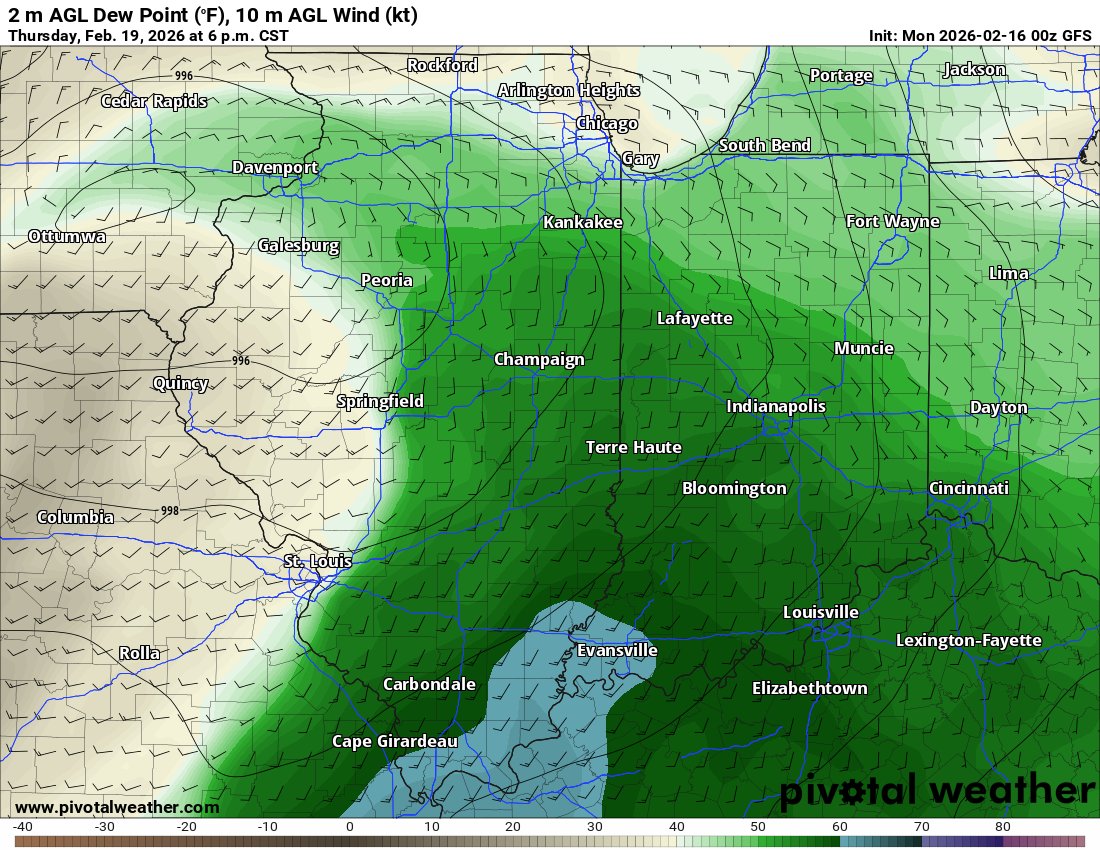
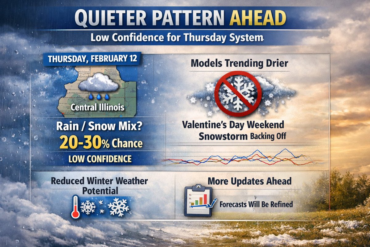
Forecast guidance continues to trend quieter across the region. A weak system may bring a rain/snow mix to parts of central Illinois on Thursday, February 12, but confidence remains low, with only a 20–30% chance based on current Euro and GFS model guidance. Recent model runs have backed away from a Valentine’s Day weekend snowstorm, signaling reduced winter weather potential during that time frame. Forecast details will continue to be refined, with additional updates later this week as confidence improves. 🌧️❄️📊
#IllinoisWeather #ForecastUpdate #WinterWeather #CentralIllinois #WeatherModels #EuroModel #GFS #RainSnowMix #ValentinesWeekend
2
767

Jan 25
That tail end of the forecast is the real stab in the heart for the bulls 🗡️❄️
I don’t personally think price will immediately react to this slightly bearish demand showing from the 2nd week of Feb onwards — but if that tail keeps dipping below the 10/30yr averages 📉, the odds of price bleeding lower increases rapidly.
Not exactly the backdrop I was looking for to support those ~$6 gas targets… basically, recent demand build hasn’t sustained, putting higher prices on thinner ice 🧊
I still believe my targets of $5.43, $5.67, $5.86 will be tagged this week 🎯 (natgas ETFs on Pepperstone) and as per my strategy from Friday, I’ll be attempting to setup shorts at those levels 🐻
Risk management will be key though — price loves nothing more than flushing shorts before sending it south ⬇️
#NatGas #NaturalGas #NG #EnergyMarkets #Commodities #FuturesTrading #WeatherModels #HDD #EnergyWeather #ColdFront #Demand
#Bearish #Volatility #RiskManagement
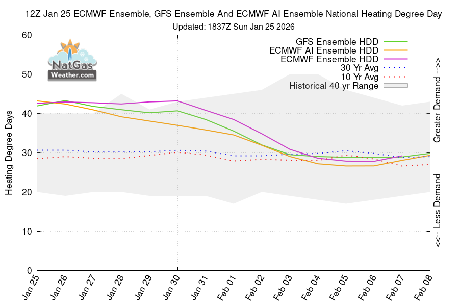
Jan 25

Weekend HDD :
GFS 1.7HDD
ECMWF -0.6HDD
ECMWF AI 6.2HDD
The days are getting warmer again.
2
459

🚨 LIVE on YouTube
Join me now as I break down the latest weather models tracking a major winter storm for Texas & Oklahoma — snow ❄️, ice 🧊, timing & impacts.
📍 Watch here ➡️
youtube.com/live/YXFplSX5TvQ…
#WinterStorm #TXwx #OKwx #WeatherModels #BreakingWeather #SnowForecast #IceStorm

3
2,434

Jan 22
After the SNOW and ICE most of the eastern third stays below average temperature wise into February. We will see a little warming, but reinforcements will be keeping us COLD into early February. @weatherbell @WeatherModels
6
15
143
31,825

All weather models are wrong, but they're also useful. Each one shows a different possibility. The trick is figuring out the probability of each scenario. #WeatherModels #Meteorology
3
1,023

そもそもWeatherModelsさんのサイトで高解像度なひまわり可視画像が掲載されていることすら知らなかった私の人生にとってかなりの損失。。
※画像の利用についてはこちらの規約を参照
weather-models.info/disclaim…
Jan 13
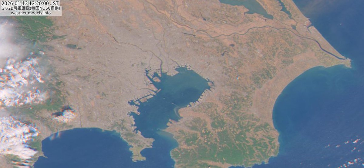
韓国の静止衛星GEO-KOMPSAT-2Bのデータを使って、毎時更新の分解能250mカラー画像のページを作って試験運用中:weather-models.info/latest/s…
ひまわり(weather-models.info/latest/h…)も他サイトに比べて倍くらいの高解像度で掲載してるけど、GK-2Bはさらにその倍の解像度。

1
1
3
553

10 Dec 2025
نعم تابع ضمن مخرجات النماذج العددية لاي مؤشرات لولادة الحالة قرب منتصف الشهر. ارض الواقع قد يكون اشد او اخف مما ظهر معي في التحليل المرفق خلي بالك . يوجد عنصر عشوائي random chaotic component بالطقس ليس بمقدوري التحكم فيه او توقعه او حتى حصره و احصائه لانه يخص الموسم الجاري و لا فكرة مسبقة ارشيفية عندي عنه لذلك توقع الزيادة اكثر من النقص من باب التفاؤل و حذر الناس لو شفت خطر محدق من مخرجات النماذج الرقمية قرب نهاية الشهر .
انا شخصيا لا اتابع النماذج الرقمية-جيفس و الاوروبي - كثيرا رغم انه معي حساب بريميوم مدفوع الاجر من weathermodels و انشغل بعملي و تحليلي الذي انشره معظمه ان لم يكن كله هو نوعي و احتمالي يهدف لتقريب التوقع البعيد للتسهيل و التيسير على الناس المختصة بالموضوع و الهواة على حد سواء .
جزاك الله خيرا .
1
5
784