
Jun 5
🌳 Virtual Tree Plantation Map using Python 🌍
What if every tree planted could be visualized on a live map? 🌱
Using Python and the powerful Leafmap library, I created a Virtual Tree Plantation Map that simulates tree plantation locations across India and displays them on an interactive satellite map.
✨ Features:
✅ Interactive map visualization
✅ Satellite imagery with Esri World Imagery
✅ Randomly generated plantation locations
✅ Custom markers for planted trees
✅ Easy to scale for real-world environmental projects
This project demonstrates how Python can be used for environmental awareness, GIS applications, and sustainability tracking.
📌 Libraries Used:
leafmap
random
💡 Real-World Applications:
🌳 Tree plantation tracking
🌍 Environmental monitoring
🏞️ Smart city green cover analysis
📍 NGO plantation campaigns
📊 Geospatial data visualization
Python isn't just for automation and AI—it can also help build solutions for a greener planet. 🌱

2
14
64
19,505

Pythonで地図を描く!leafmap徹底解説
leafmapは、地理空間データを可視化・解析するライブラリです。
foliumやipyleafletをベースにしており、データサイエンティストやGISエンジニア、リモートセンシングの専門家にも役立つツールです。
#Python #プログラミング初心者
gomafree-tech.com/?p=3567
2
50
432

Apr 30
🚨 Arkadaşlar, coğrafi veri analizi ve görselleştirme dünyasında çok güçlü bir açık kaynak proje çıktı.
**GeoAgent**, leafmap, STAC, NASA Earthdata workflow’ları ve QGIS plugin’lerini bir araya getirerek tamamen Python tabanlı, coğrafi odaklı AI ajanları oluşturmanızı sağlıyor.
Uzamsal analiz, harita üretimi, uydu verisi işleme ve karmaşık GIS iş akışlarını AI ajanlarıyla otomatikleştirmek isteyenler için oldukça iddialı bir araç.
Tatilde veya hafta sonu denemek isteyenler için ideal bir repo.
🔗 GitHub: github.com/opengeos/GeoAgent
Sizce GeoAgent gibi araçlar, coğrafi veri analizi ve GIS iş akışlarını ne ölçüde dönüştürecek?
Düşüncelerinizi yorumlara yazın, beraber konuşalım. 🗺️
4
66
423
25,136

leafmapなどのPythonパッケージや、STACやNASA Earthdataのワークフロー、QGISプラグインなどをツールとして扱い、地理空間的な分析や可視化を行うAIエージェントを実現するのか
連休中に触っておきたいな
github.com/opengeos/GeoAgent
1
19
141
5,330


Jan 9
Comparing geospatial layers in QGIS just got a lot easier.
The new Leafmap QGIS plugin introduces intuitive visual tools that let you compare raster and vector layers side-by-side, directly inside your QGIS workflow.
 Qiusheng Wu
1
26
201
7,236

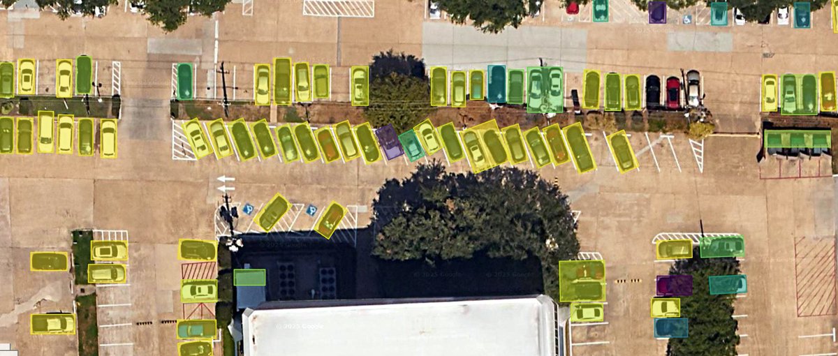
Interesting ... 81 buildings - leafmap share.google/gcialG5MCJ4akYu…
Jan 6

One line of code.
That’s all it takes to get access to Google Open Buildings, the largest building dataset, for any country.
100% free and available globally.
3
291

31 Dec 2025
A Look Back at My Open-Source Journey in 2025!
As 2025 comes to a close, I’d like to share a brief summary of my open-source and content-creation work this year.
I worked intensively on five open-source projects, including GeoAI, SamGeo, Leafmap, AnyMap, and Geemap. They together have accumulated nearly 14,000 GitHub stars. You can follow ongoing updates and releases on GitHub: github.com/opengeos
In parallel, I published 145 videos on YouTube. My YouTube channel has gained 57K subscribers, reached 2.7M views, and accumulated 143K watch hours. If you’re interested in geospatial Python, GeoAI, and open-source workflows, feel free to subscribe: youtube.com/@giswqs
I also shared more than 160 original posts across social media, engaging with the community and documenting new features, tutorials, and releases. You can find me across platforms using the handle @giswqs.
This year, I published two books: Introduction to GIS Programming (gispro.gishub.org) and Spatial Data Management with DuckDB (duckdb.gishub.org), both focused on practical, open-source geospatial workflows.
I’m deeply grateful for the feedback and support from the open-source and geospatial communities. If you have suggestions for improving my current projects, or ideas for new ones to explore in 2026, I’d love to hear them in the comments.
Wishing everyone a productive 2026! 🎉
#OpenSource #GIS #GeoAI #Python #Geospatial #DataScience

10
21
151
8,254
30 Dec 2025
Compare Layers Visually in QGIS — New Leafmap Plugin Demo!
Discover the new QGIS plugin for Leafmap that makes comparing geospatial layers easier than ever! Whether you're working with raster or vector data, this tool brings interactive transparency controls and a layer swipe feature right into your QGIS environment.
GitHub repo: github.com/opengeos/qgis-lea…
Video tutorial: youtu.be/glBgnyS8IDY
#QGIS #geospatial #opensource #datascience
1
26
201
9,272

29 Dec 2025
Integrate Mapillary directly with #leafmap and #MapLibre 🌍
Create your own web map application for viewing street level imagery.
Try the API here, completely free : mapillary.com/developer
Guide by Qiusheng Wu : youtube.com/watch?v=OIFQXdSb…
#Mapillary
3
4
560

26 Dec 2025
2. What it does
The package provides 6 core capabilities:
1. Interactive and programmatic search and download of remote sensing imagery and geospatial data.
2.Automated dataset preparation with image chips and label generation.
3. Model training for tasks such as classification, detection, and segmentation.
4. Inference pipelines for applying models to new geospatial datasets.
5. Interactive visualization through integration with Leafmap and MapLibre.
6. Seamless QGIS integration via a dedicated GeoAI plugin, enabling users to run AI-powered geospatial workflows directly within the QGIS desktop environment, without writing code.
1
256
18 Dec 2025
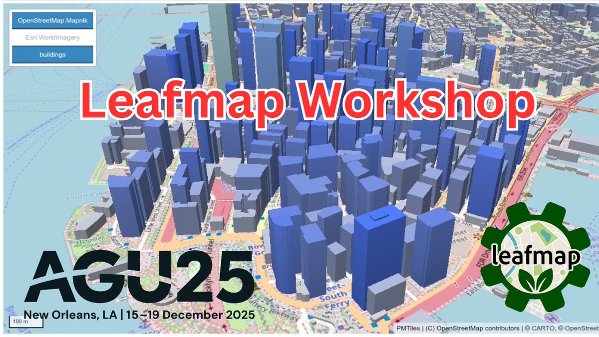
The recording of the leafmap workshop at #AGU25 is now available.
Video: youtu.be/XO_6OIA6ars
Notebook: agu2025.workshops.geojupyter…
In this workshop, you will learn how to:
Create interactive maps with MapLibre using Python
Add and customize various data layers (raster, vector, 3D)
Visualize remote sensing data including COGs, STAC, and local rasters
Work with PMTiles for efficient vector tile rendering
Create 3D visualizations including terrain, buildings, and indoor maps
Use TiTiler for dynamic raster tile serving
Apply custom styling and legends to enhance map readability
#geospatial #leafmap #jupyter #python #datascience
1
18
107
4,961
10 Dec 2025
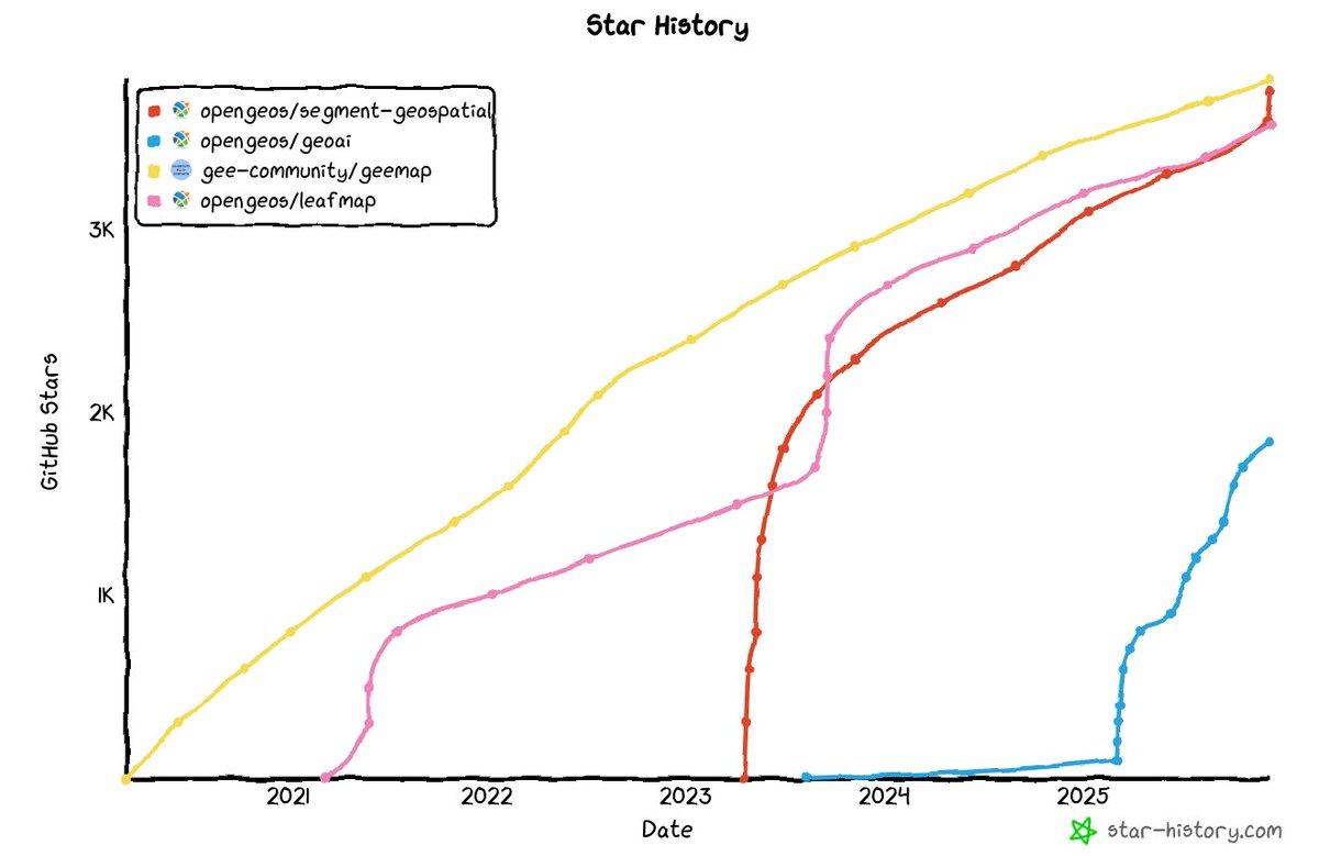
Four of my open-source geospatial projects have collectively surpassed 13K GitHub stars ✨ . Thank you to everyone who has used, contributed to, or shared these tools. You’re the reason the community keeps growing.
If any of these projects have been helpful in your work, consider giving them a ⭐ on GitHub:
Geemap: github.com/gee-community/gee…
Leafmap: github.com/opengeos/leafmap
SamGeo: github.com/opengeos/segment-…
GeoAI: github.com/opengeos/geoai
Explore more of my open-source work: github.com/opengeos
#geospatial #opensource #datascience #python
3
14
88
3,422
17 Nov 2025
🚀 Spatial Data Management with DuckDB: Book Release Code Walkthrough Video!
Watch the walkthrough: youtu.be/RIJQ3WuGJkc
Book website: duckdb.gishub.org
GitHub repo: github.com/giswqs/duckdb-spa…
Table of Contents: books.gishub.org/duckdb/book…
PDF edition (Leanpub): leanpub.com/duckdb
Full-color print edition (Amazon): amazon.com/dp/B0G2JFMFFC
#duckdb #geospatial #opensource #python #leafmap #SQL
2
36
142
7,015

17 Nov 2025
I bought this book.
leafmapの著者の人が書いた、Spatial data managemagement with DuckDB 「DuckDBによる(地理)空間情報管理」を買った。
15 Nov 2025
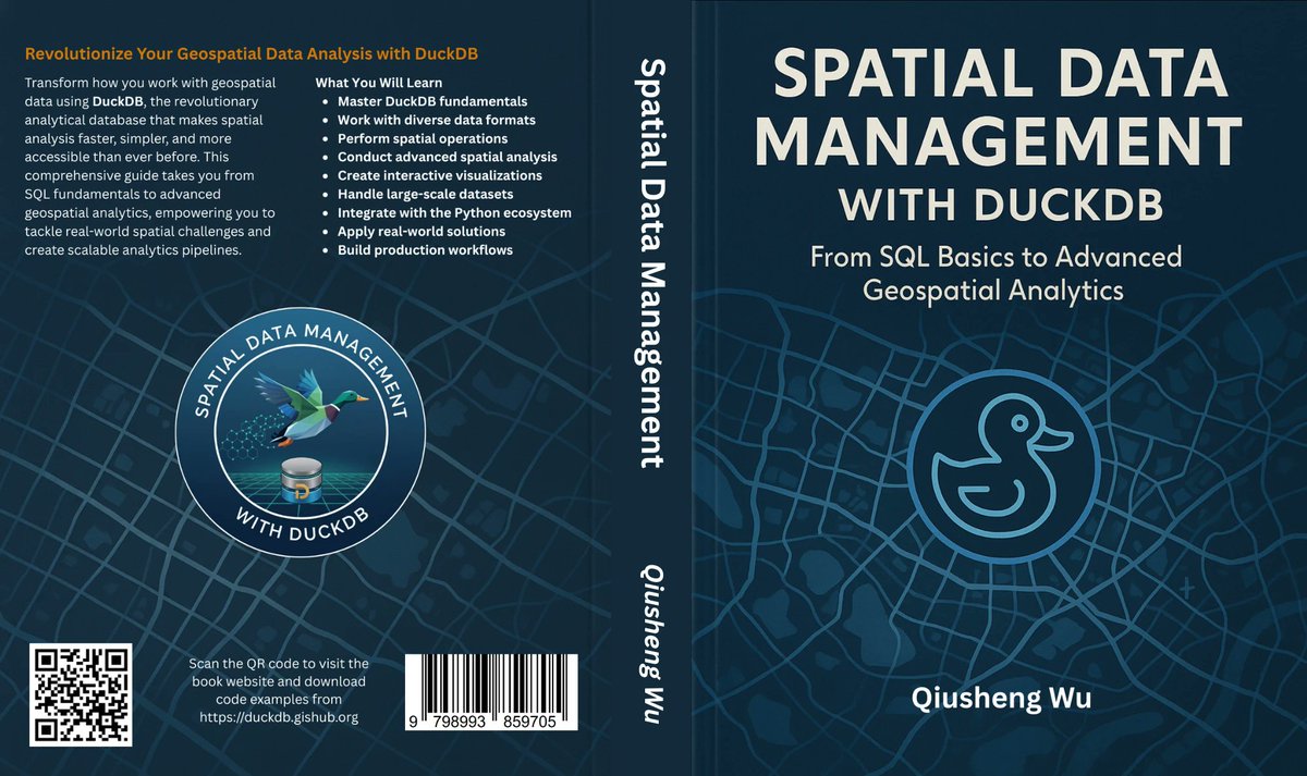
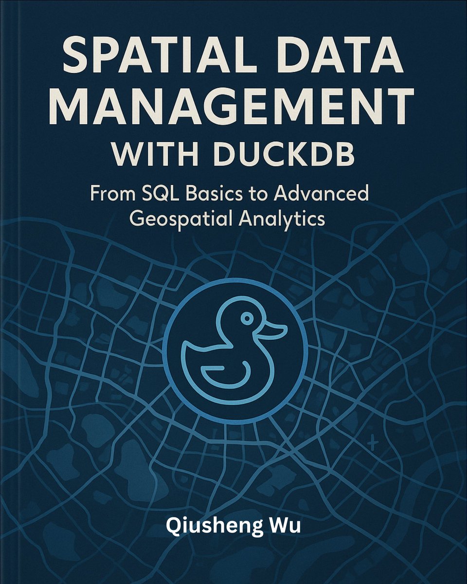
I’m thrilled to share that my new book (Spatial Data Management with DuckDB) is now published! 🎉
At 430 pages, this book provides a practical, hands-on guide to scalable geospatial analytics and visualization using DuckDB. All code examples are open-source and freely available on GitHub so you can follow along, adapt, and extend them.
Book website: duckdb.gishub.org
GitHub repo: github.com/giswqs/duckdb-spa…
Table of Contents: books.gishub.org/duckdb/book…
The PDF edition of the book is available on @leanpub: leanpub.com/duckdb
Full-color print edition will be available on Amazon soon. Stay tuned.
#geospatial #duckdb #python #leafmap #datascience
1
5
674
15 Nov 2025
I’m thrilled to share that my new book (Spatial Data Management with DuckDB) is now published! 🎉
At 430 pages, this book provides a practical, hands-on guide to scalable geospatial analytics and visualization using DuckDB. All code examples are open-source and freely available on GitHub so you can follow along, adapt, and extend them.
Book website: duckdb.gishub.org
GitHub repo: github.com/giswqs/duckdb-spa…
Table of Contents: books.gishub.org/duckdb/book…
The PDF edition of the book is available on @leanpub: leanpub.com/duckdb
Full-color print edition will be available on Amazon soon. Stay tuned.
#geospatial #duckdb #python #leafmap #datascience
15
92
511
27,608
11 Nov 2025
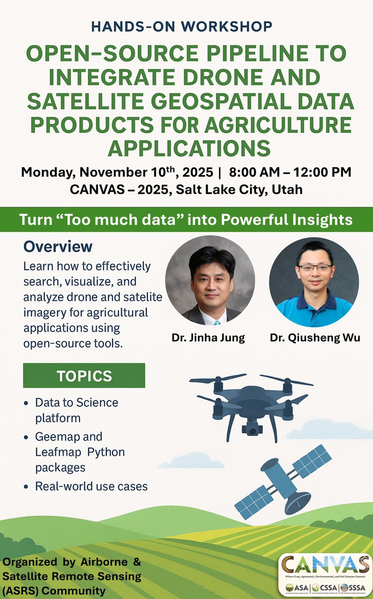
🚁✨ Workshop Recordings Now Live from CANVAS 2025!
Yesterday at the CANVAS 2025 Conference in Salt Lake City, Dr. Jinha Jung and I had the pleasure of leading a 4-hour hands-on workshop on managing and analyzing drone imagery using open-source tools.
If you work with drone or satellite data in agriculture, environmental research, or geospatial AI, you won’t want to miss this.
👉 Sign up for a FREE D2S account: ps2.d2s.org
Learn how to upload, manage, and analyze drone/satellite data using the Data to Science (D2S) platform and Python tools like SAMGeo, GeoAI, and Leafmap.
📌 Watch the Sessions:
▶️ Part 1: Intro to D2S – Drone Imagery Management Platform
🔗 youtu.be/G1SVyMnIJ9c
▶️ Part 2: Analyzing Drone Imagery with SAMGeo & GeoAI
🔗 youtu.be/UJYSVHF6taQ
🧰 Key Resources:
Event Info: scisoc.confex.com/scisoc/202…
Workshop Notebook: opengeoai.org/workshops/CANV…
Leafmap: leafmap.org
SAMGeo: samgeo.gishub.org
GeoAI: opengeoai.org
D2S Platform: ps2.d2s.org
D2S Python API: py.d2s.org
#CANVAS2025 #DroneImagery #GeoAI #OpenSource #geospatiala #D2S
3
50
178
7,986
6 Nov 2025
Learn how to visualize Cloud Optimized GeoTIFFs (COGs) right in your browser – no tile server is needed! In this step-by-step tutorial, you'll discover how to load and render COGs instantly using Leafmap within a Jupyter Notebook.
Whether you're working with aerial imagery, LiDAR datasets, or multiband raster data, this guide shows you how to:
Load GeoTIFFs via HTTP URLs
Customize indices, colormaps, and opacity
Combine imagery, elevation & vector data in one map
Run everything 100% serverless in your browser!
👉 Notebook example: leafmap.org/notebooks/108_ad…
📺 Full video tutorial on YouTube: youtube.com/@giswqs/videos
#geospatial #opensource #leafmap #python
1
28
252
7,955
26 Oct 2025
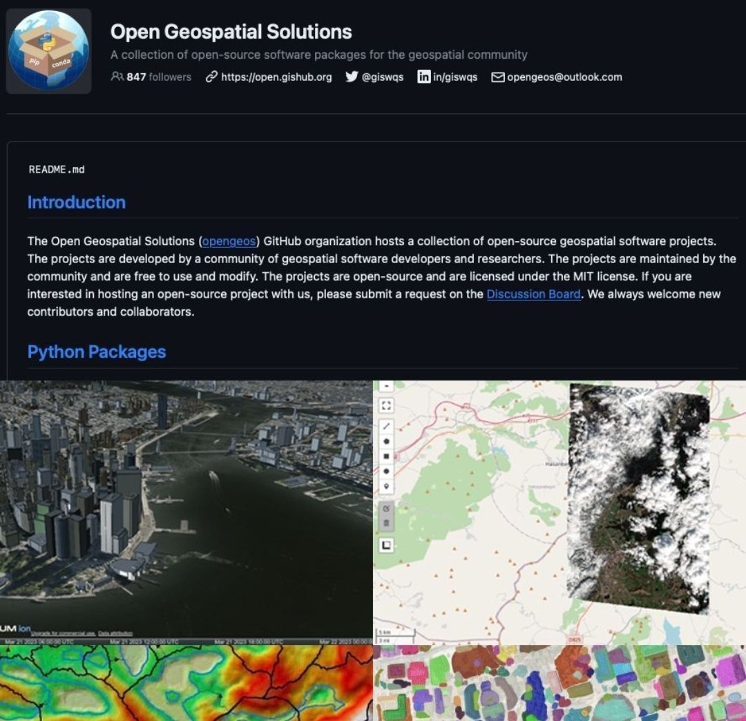
Do you know about Open Geospatial Solutions?
The Open Geospatial Solutions (opengeos) GitHub organization hosts a collection of open-source geospatial software projects. The projects are developed by a community of geospatial software developers and researchers
Their collection as of today:
Python Packages
- earthformer: ow.ly/2onl50PZm8i
- geemap: ow.ly/AK7x50PZm88
- geoai: ow.ly/64wE50PZm83
- geospatial: ow.ly/1PPM50PZm8h
- geospatial-ml: ow.ly/p9BPf50PZm86
- leafmap: ow.ly/6wJR50PZm8m
- lidar: ow.ly/rxTP50PZm8j
- mapwidget: ow.ly/QfH250PZm7Y
- open-buildings: ow.ly/7L2M50PZm81
- pygis: ow.ly/xtX650PZm8f
- segment-anything-py: ow.ly/mKnM50PZm8c
- segment-geospatial: ow.ly/moZi50PZm7X
- whitebox-python: ow.ly/JF8I50PZm8o
- whiteboxgui: ow.ly/vPyM50PZm82
Data Catalogs
- geospatial-data-catalogs: ow.ly/ocT050PZm8p
- aws-open-data: ow.ly/CNJQF50PZm8b
- aws-open-data-geo: ow.ly/t1Vz50PZm7W
- aws-open-data-stac: ow.ly/i5Ir50PZm8k
- Earth-Engine-Catalog: ow.ly/UW9150PZm8e
- NASA-CMR-STAC: ow.ly/KX0j50PZm8l
- stac-index-catalogs: ow.ly/YQma50PZm85
- maxar-open-data: ow.ly/CI7j50PZm84
- data: ow.ly/3muu50PZm7Z
For more, follow them here: ow.ly/sFZf50PZm87
open.github.org 🐦 @giswqs opengeos@outlook.com

13
114
4,214
26 Oct 2025
Do you know about Open Geospatial Solutions?
The Open Geospatial Solutions (opengeos) GitHub organization hosts a collection of open-source geospatial software projects. The projects are developed by a community of geospatial software developers and researchers
Their collection as of today:
Python Packages
- earthformer: ow.ly/2onl50PZm8i
- geemap: ow.ly/AK7x50PZm88
- geoai: ow.ly/64wE50PZm83
- geospatial: ow.ly/1PPM50PZm8h
- geospatial-ml: ow.ly/p9BPf50PZm86
- leafmap: ow.ly/6wJR50PZm8m
- lidar: ow.ly/rxTP50PZm8j
- mapwidget: ow.ly/QfH250PZm7Y
- open-buildings: ow.ly/7L2M50PZm81
- pygis: ow.ly/xtX650PZm8f
- segment-anything-py: ow.ly/mKnM50PZm8c
- segment-geospatial: ow.ly/moZi50PZm7X
- whitebox-python: ow.ly/JF8I50PZm8o
- whiteboxgui: ow.ly/vPyM50PZm82
Data Catalogs
- geospatial-data-catalogs: ow.ly/ocT050PZm8p
- aws-open-data: ow.ly/CNJQF50PZm8b
- aws-open-data-geo: ow.ly/t1Vz50PZm7W
- aws-open-data-stac: ow.ly/i5Ir50PZm8k
- Earth-Engine-Catalog: ow.ly/UW9150PZm8e
- NASA-CMR-STAC: ow.ly/KX0j50PZm8l
- stac-index-catalogs: ow.ly/YQma50PZm85
- maxar-open-data: ow.ly/CI7j50PZm84
- data: ow.ly/3muu50PZm7Z
For more, follow them here: ow.ly/sFZf50PZm87
open.github.org 🐦 @giswqs opengeos@outlook.com
5
73
367
18,596