
Apr 10
The Survey of India commemorates National Survey Dayon 10 April, marking the historic beginning of the Great Trigonometrical Survey.
The Great Trigonometrical Survey (GTS), spanning from Cape Comorin (Kanyakumari) to the Himalayas, aimed to measure the meridian arc of the Earth and map the subcontinent with precision. The first baseline of GTS was measured near St. Thomas Mount, Madras, on 10 April 1802, from where the triangulation series extended across India using the 36-inch great theodolite, laying the foundation for first of it’s kind scientifically accurate mapping for nation-building.
Survey of India continues this legacy today, leveraging advanced geospatial technologies to support precise mapping, planning, and development across the nation.
On this occasion, Survey of India extends warm greetings to the entire geospatial community and all citizens, honoring the pioneers and professionals who make India’s surveying and mapping journey possible.
@DrJitendraSingh @karandi65 @IndiaDST
#SurveyOfIndia #NationalSurveyDay #NSD2026 #GreatTrigonometricalSurvey #GeospatialIndia #MappingIndia #Surveying #DigitalIndia #PrecisionMapping #ViksitBharat
[GeospatialTechnology, SurveyLegacy, NationBuilding, MappingHistory, PrecisionSurveying]
4
9
175
Mar 25
Survey of India inaugurated a CORS Station in Kurnool District, Andhra Pradesh on 23 March 2026 under the NAKSHA Project.
The station was inaugurated by Shri Noorul Quamer, IAS, Joint Collector & Addl. District Magistrate, Kurnool, accompanied by Shri B.C. Parida, Director, AP & T GD, Hyderabad, marking a significant step towards strengthening high-precision geospatial infrastructure in the region.
This initiative will support accurate positioning, modern surveying applications, and improved planning and development activities. It reflects the continued efforts to enhance India’s geospatial capabilities through advanced technologies.
@DrJitendraSingh @karandi65 @IndiaDST @AndhraPradeshCM @governorap @OurKurnool
#SurveyOfIndia #CORS #NAKSHA #GeospatialIndia #MappingIndia #Surveying #DigitalIndia #AndhraPradesh #Kurnool #GeospatialInfrastructure
[GeospatialTechnology, CORSStation, PrecisionMapping, SurveyingIndia, InfrastructureDevelopment, DigitalMapping, NAKSHAProject]
2
4
237

25 Jun 2025
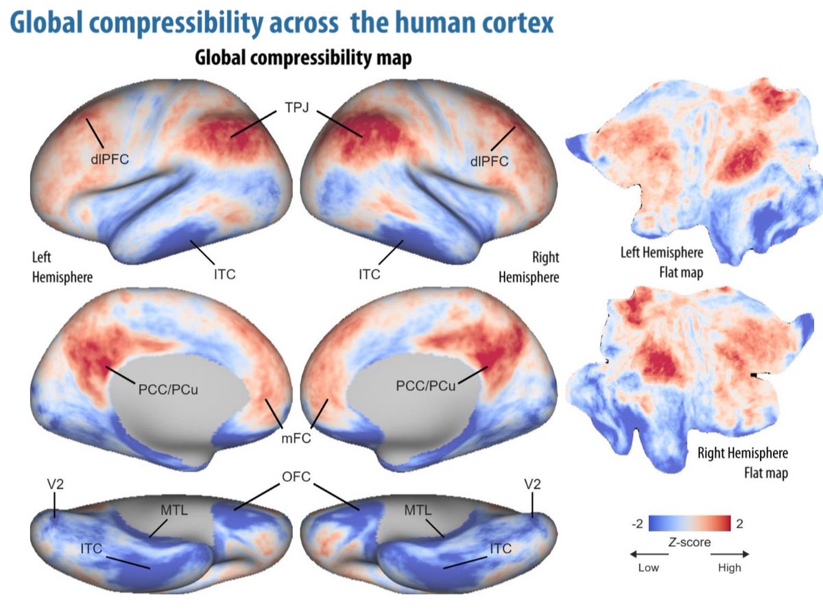
Kaixiang Zhuang mapping out how different brain regions contribute to the global compression of conceptual knowledge 🗜️🧠🗜️
#precisionmapping
1
2
65

23 Jun 2025
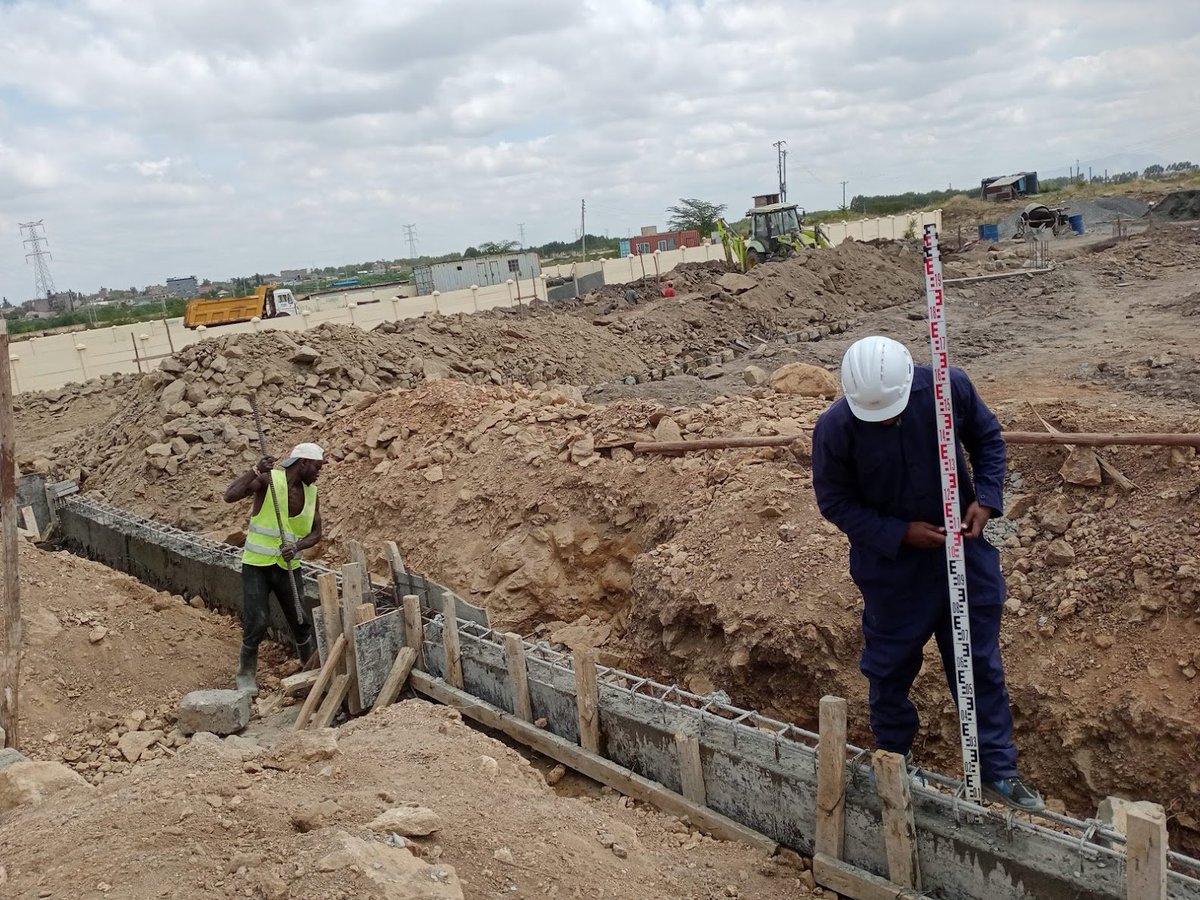
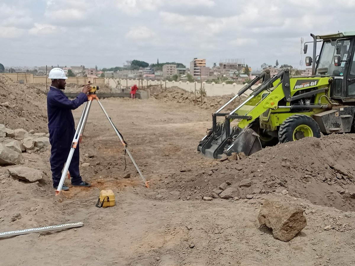
Ever wondered how mining sites are mapped so precisely?
The #Total_Station does it all ! From measuring distances, angles, and elevations with 100% accuracy, this tool ensures safety & smarter decisions on-site.
#TotalStation #MinePlanning #PrecisionMapping #MiningEquipment

2
141

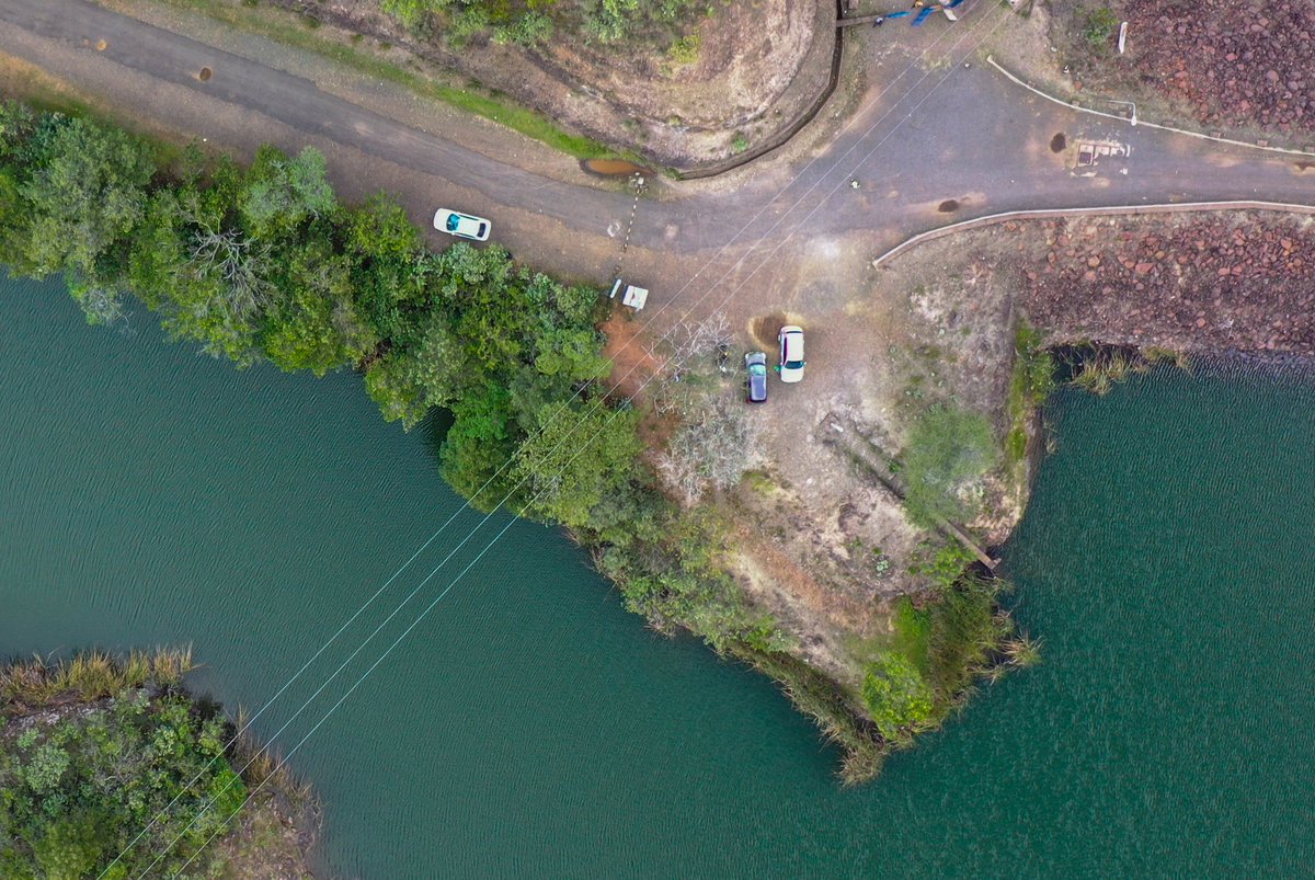
3 Jun 2025
From flight planning to data processing, we bring accuracy, efficiency, and innovation to every site we fly.
📞 254 735 931 370
🌐 skymap-geo.com
#SkymapAfrica #DroneSurveying #MappingSolutions #PrecisionMapping #SurveyingAfrica #GISKenya #TopographicMapping
3/3
2
77

16 May 2025
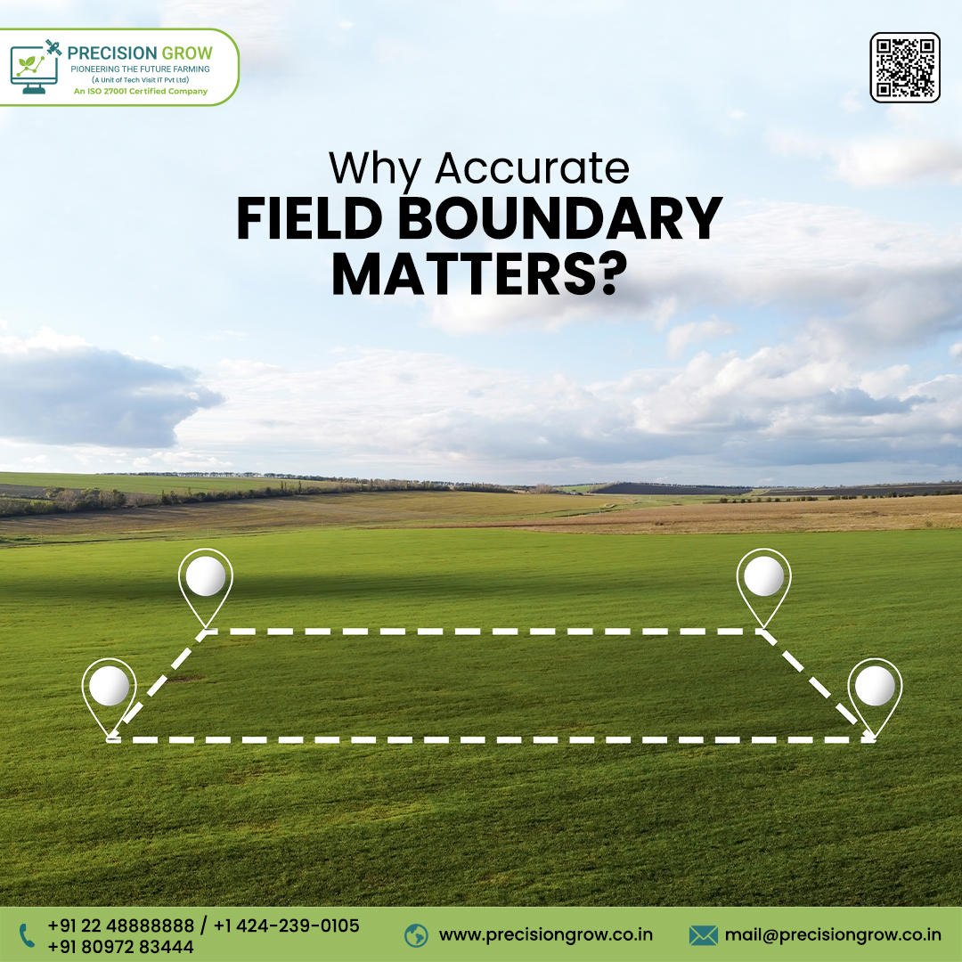
🌾 Why do accurate field boundaries matter? More than you think! 🧭
Imagine applying fertilizer… but overshooting the border and wasting half of it 😬
Or harvesting... only to realize your data was off by 10 meters 📉
Sounds frustrating, right?
That’s where Precision Grow steps in! 💡
With accurate field boundary mapping, you get more than just clean edges —
✅ You cut down costs 💰
✅ You boost yield 📈
✅ You make smarter pre-production decisions 🧠
✅ You plan logistics like a pro 🚜
✅ And yes… you’re all set for autonomous farming robots too 🤖
✨ Want to map your fields the smart way?
📲 DM us or visit: precisiongrow.co.in
.
.
#smartfarming #PrecisionMapping #AgriTechIndia #FarmBoundariesMatter #VRTFarming #SustainableAgriculture #AutonomousFarming #FarmingFuture #AgriInnovation #digitalfarming

1
5
422

30 Apr 2025
Unlock your land’s potential with GiBLand Survey Limited! We offer precise line staking, seamless mutation surveys, and accurate beacon re-establishment using advanced technology. Secure your property today—contact or WhatsApp us!
#LandSurveying #PrecisionMapping #GiBLandSurvey
1
56

15 Feb 2025
📡 Topcon Unveils HiPer XR GNSS Precision Positioning for Construction & Surveying 🏗️
🌟 Topcon’s HiPer XR GNSS is setting new standards in accuracy, reliability, and efficiency for surveying, construction, and geospatial applications. Discover how this cutting-edge technology is revolutionizing positioning and site management.
📖 Read the full article on Highways Today:
highways.today/2025/02/07/to…
#Topcon #HiPerXR #GNSS #HighwaysToday #ConstructionNews #SurveyingTech #PrecisionMapping #GeospatialInnovation #FutureOfConstruction #SmartInfrastructure

4
5
86

5 Feb 2025
🏗️ 📐 At Orion Geospatial, we provide precision surveys for industrial & residential construction, delivering mm-level accuracy for contractors & developers. Let’s build smarter.
#Surveying #Construction #PrecisionMapping #OrionExperts

1
2
11
388
1 Jan 2025
As we welcome 2025, the Survey of India proudly reflects on a year of impactful contributions and reaffirms its commitment to advancing national development through cutting-edge geospatial technology and precision mapping.
In 2024, we made significant strides with initiatives such as the National Mission for Clean Ganga (NMCG), SVAMITVA, National Hydrology Project (NHP), Indian Antarctica Research Programme, and Operation DRONAGIRI, alongside other key undertakings that exemplify our dedication to progress and precision.
For 2025, we aim to further our contributions with projects like NAKSHA 2.0, Indian Highway and Railway Corridor Mapping, AMRUT 2.0, and additional initiatives focused on strengthening infrastructure, sustainable development, and driving transformation across urban and rural landscapes.
The Survey of India remains unwavering in its mission to deliver reliable, accurate geospatial data to drive India’s development. Together, let us continue mapping a brighter, stronger, and more prosperous future.
Wishing you a Happy New Year 2025.
@DrJitendraSingh @karandi65 @IndiaDST
#SurveyOfIndia #NewYear2025 #GeospatialTechnology #NationalDevelopment #MappingTheFuture #PrecisionMapping #GIS #SustainableGrowth
1
7
197

5 Dec 2024
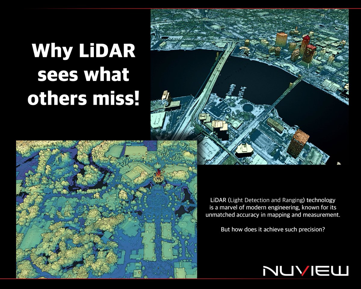
𝐖𝐡𝐲 𝐋𝐢𝐃𝐀𝐑 𝐬𝐞𝐞𝐬 𝐰𝐡𝐚𝐭 𝐨𝐭𝐡𝐞𝐫𝐬 𝐦𝐢𝐬𝐬!
LiDAR uses laser pulses & extreme sensitivity to time to measure distances and create detailed 3D maps. It captures what others can’t - like canopy layers or urban layouts.
For example:
🌳 𝘍𝘰𝘳𝘦𝘴𝘵𝘳𝘺: Monitor tree heights & density for sustainable management.
🏙️ 𝘜𝘳𝘣𝘢𝘯 𝘱𝘭𝘢𝘯𝘯𝘪𝘯𝘨: Design smarter, greener cities.
#NUVIEW #SpaceLiDAR #LiDAR #EarthObservation #PrecisionMapping #GeospatialInnovation #FutureTech #Innovation
2
3
125

25 Nov 2024
This week's update on @TakshashilaInst Expert Course on Geospatial Science and Technology!
From maps that guide us to geodesy that measures the Earth—this week was a deep dive into precision and perspective!
Participants explored the art and science of cartography, tracing maps' journey from tradition to tech, and tackled geodesy, unlocking the secrets to Earth's shape and positioning.
A huge shoutout to Cmde (Dr) @Arun_Golaya for turning the complexities of geodesy into an engaging and enlightening experience.
#GeospatialScience #Cartography #Geodesy #PrecisionMapping #TakshashilaInstitution
2
2
5
721
15 Aug 2024
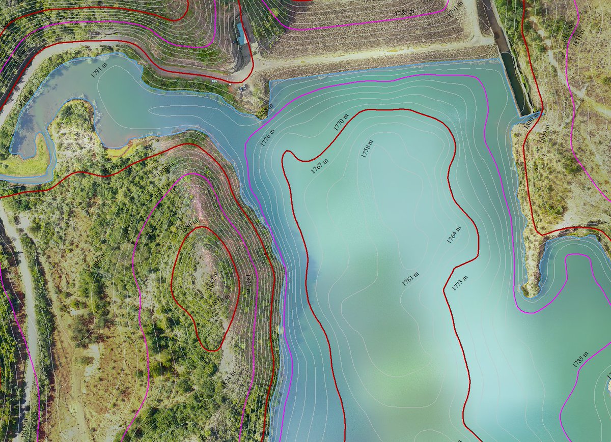
At skymap Africa, our expert team recently completed an advanced survey project, combining drone LiDAR topography of the dam vicinity with sonar bathymetry. .
#Dronemapping #Bathymetricsurvey #Africa #Environmentalmonitoring #Hydropower #Contourmapping #Precisionmapping


2
2
107

15 Jul 2024
Transform Security with axldrone’s Accurate Mapping
#accuratemapping #dronesecurity #precisionmapping #safetywithaxldrone #axldrone
axldrone.com/
1
2
18

26 Jun 2024
Revolutionizing Agriculture: A New Era of Precision Mapping in Asia and the Pacific devdiscourse.com/article/sci…
#PrecisionFarming #PrecisionMapping #DigitalAgriculture #SmartFarming #DataDrivenAg #FarmTech #AgriTech #Satellites4Ag #Farming #CropMapping #YieldMapping #SoilMapping
73

26 Nov 2023
Dive into the world of precision mapping with Ideal Solutions! Our 3D and HD Mapping Solutions redefine how you visualize and analyze data. Ready to see the world in a new dimension? Contact us today! #PrecisionMapping #DataAnalysis #3DMapping

2
2
2
33

11 Nov 2023
⚙️ Precision in every degree! Enhance your temperature mapping strategies with a personalized consultation.
Book now for industry-leading expertise.
#PrecisionMapping #Consultation
3
21

8 Sep 2023
🌱As we conclude our @DJIGlobal AgriTech series with Precision Mapping, we want to remind you to unlock the true full potential of your fields’ year-end harvests with the power of data that @DJIAgriculture drones provide.
#DJIAgriculture #PrecisionMapping #DataPower #FortSask

1
2
68

22 Aug 2023
LiDAR Drones: The Next Big Thing in Technology Innovation.
Factors such as the rise in the adoption of LiDAR drones for mining applications, growth in investments in smart city projects, and expansion in applications in civil and defense engineering are the major drivers for the market. Moreover, the factors such as stringent restrictions and regulations related to the use of drones in various countries, lack of trained personnel to operate LiDAR drones, and high operational and purchasing costs restrain the growth of these drones.
Furthermore, factors such as the rise in the adoption of aerial data collection tools for environmental purposes and higher investments in the drone industry create lucrative opportunities for leading players of LiDAR drone products operating in the market.
📈Explore the market overview: tinyurl.com/3rdxskew
#AMR #alliedmarketresearach #alliedmarketresearchinsight #LiDAR #DroneTech #3DMapping #HighResolutionData #LaserMapping #RemoteSensing #GeospatialTech #TerrainMapping #LiDARMapping #AerialSurvey #PrecisionMapping #DataVisualization #GISMapping #LiDARScanning #Geomatics #EnvironmentalMonitoring #LiDARTechnology #DroneMapping #LiDARDrones #GISData

2
64

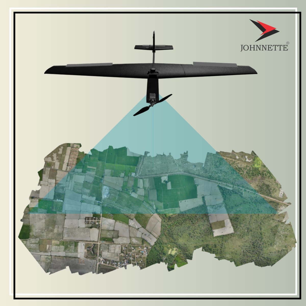
18 Aug 2023
Introducing the Johnnette JF-2 Mapper, revolutionizing traditional large-scale terrain mapping with state-of-the-art drone technology for accurate data collection.
#MappingRevolution #JF2Mapper #CuttingEdgeMapping #DroneTech #PrecisionMapping #MappingSolutions #drone #johnnette
2
4
330