
Meteorologist - hurricane and agricultural commodities specialist. Always curious to learn more and delve deeper. Tea and dark chocolate lover.
Joined February 2009
- Tweets 72,308
- Following 1,751
- Followers 2,250
- Likes 48,548
1,243 Photos and videos


Yaakov Cantor retweeted

Highly unusual storm system ... but taking enormous tropical moisture w/weak low pressure frontal boundary = plenty of convergence, upper-level energy to provide a "baroclinic" energy pathway even over land.
30% chance of TD 01L (then Arthur) but technically a name doesn't matter as the IMPACTS will be substantial regardless
1
5
21
4,636
Yaakov Cantor retweeted
A tropical system will form along/near the coast of South Texas by Tuesday (30% chance) and then combine with a frontal boundary while heading through the Southeast. This hybrid structure --> TD/TS intensity while over land into next weekend.
--> boatloads of rain 🚣
2
16
79
8,765
Yaakov Cantor retweeted

The National Hurricane Center has increased chances of a depression or tropical storm forming in the NW Gulf later this week.
Interests in Texas & Louisiana should monitor the progress of this disturbance. First name on the list is #Arthur.
#tropicalupdate 🍋🌀

10
49
5,666
Yaakov Cantor retweeted

Jun 13
⛈️STORM AFTERMATH: Powerful winds ripped down a gas station awning in Bartlett, Illinois, 35 miles north of Chicago on Thursday. Parts of Chicago were under a Tornado Warning during a severe weather outbreak. More storms are expected to develop across the Midwest this afternoon. Watch FOX Weather for the latest severe weather coverage:
1
14
25
2,840
Yaakov Cantor retweeted

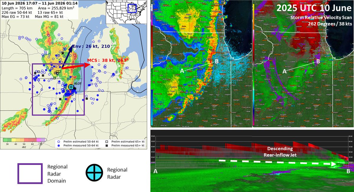
Jun 10
Here is a 6 hour loop of the likely Derecho we just had through the Midwest impacting Madison, Wisconsin and Chicago, now moving through Michigan. Check out all the reports of wind damage and measurements that have come in so far!
Round 2 is brewing in Eastern Iowa and will make its way across some of the same areas that were impacted just hours before.
More rounds of significant storms are also expected in the same area tomorrow...
7
63
474
43,022
Yaakov Cantor retweeted

The damaging wind swath from Wednesday, June 10 has been preliminarily confirmed as a derecho.
The wind swath had a track length over 400 miles with a footprint just under 100,000 square miles. The strongest known gust was measured at over 94 mph.
14
325
1,373
217,309

Yaakov Cantor retweeted
Jun 11
WOW! Windows in HIGH RISES were blown out in Chicago, Illinois after DESTRUCTIVE thunderstorms swept across the city earlier this afternoon!
Thank you to Sheila for sending this in!

25
133
1,278
87,896
Yaakov Cantor retweeted

The dying Iowa blob that spent the last 12 hours riding in from Nebraska now crossing #Chicago with a whimper
DON’T BE FOOLED!
This is not by any means today’s main event. Just a palette cleanser for the Dinnertime (4-7PM) main course forecast severe event to come
8
12
97
20,525
Yaakov Cantor retweeted

Jun 11
Severe storms left a trail of destruction across parts of the Midwest yesterday, including areas just outside Chicago. The following images are from Illinois, where a building sustained significant roof damage in Kane County, while whole trees were toppled and branches were snapped in Palos Park, a village located about 19 miles southwest of downtown Chicago. Additionally, Chicago's Midway Airport recorded a 72-mph gust as the same severe storm that can be seen across the horizon overlooking downtown Chicago in the bottom-righthand image passed through.
Tormentas severas dejaron un rastro de destrucción en partes del Medio Oeste ayer incluyendo algunas áreas justamente fuera de Chicago. Las siguientes imágenes son de Illinois, donde un edificio sufrió daño de techo significativo en el Condado Kane, mientras que vimos árboles enteros en el suelo y ramas de árbol rotas en Palos Park, que es un pueblo ubicado a unas 19 millas al suroeste del centro de Chicago. Además, el Aeropuerto Midway en Chicago registró una ráfaga de 72 mph con el paso de la misma tormenta severa que se muestra en la imagen de abajo a la derecha a lo lejos en el horizonte con vistas desde el centro de Chicago.

1
868
Yaakov Cantor retweeted

Jun 11
HEADS UP!! 🌬️ The winds were HOWLING in downtown Chicago Wednesday afternoon as strong storms raced through Northern Illinois - with multiple reports of wind related damage around the greater Chicago area. Flying pool chairs may be another hazard of today as more severe is expected in the Midwest.
#ILwx
5
25
3,012

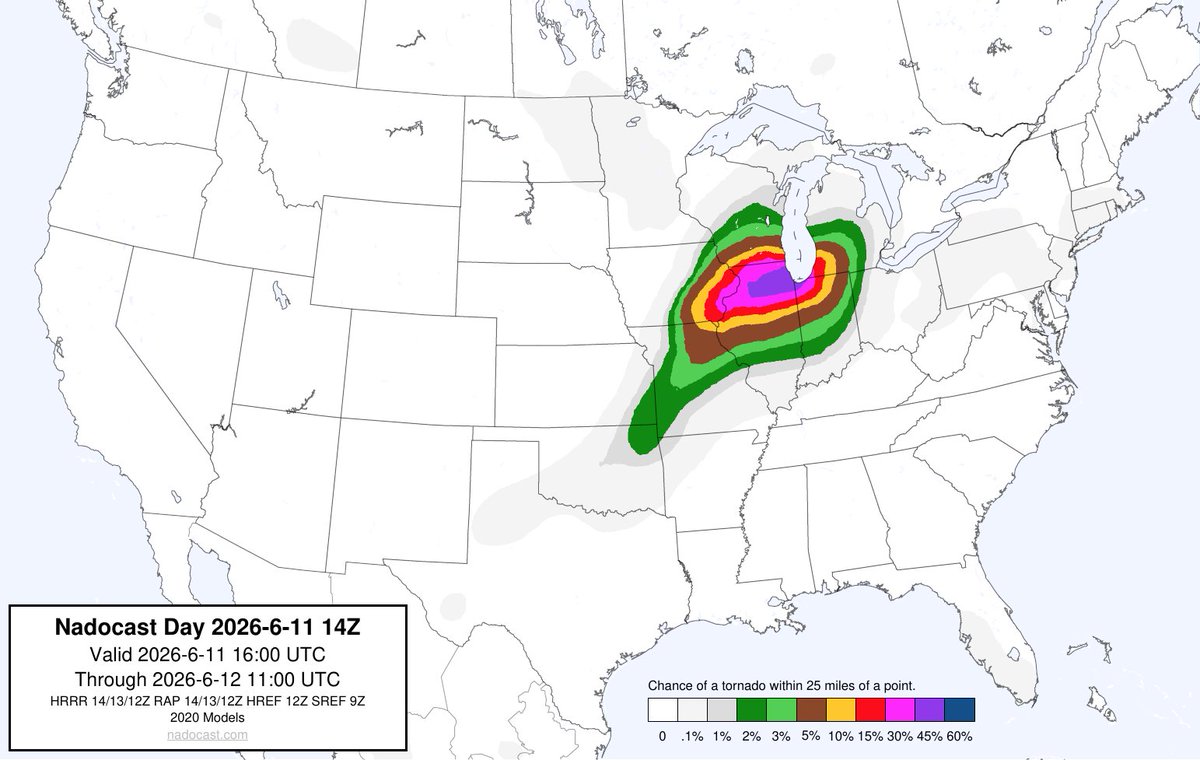
Jun 11
Let's see how this ML-based tornado outlook for today verifies. While the main risk is likely QLCS tornadoes vs. long-lived supercells, these can still do significant damage. Watch out anywhere from Davenport and Dubuque, IA metros through northern IL, far southern WI and NW IN!

1
328
Yaakov Cantor retweeted

Jun 8
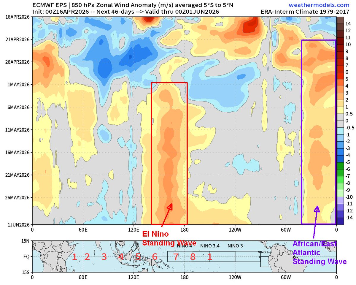
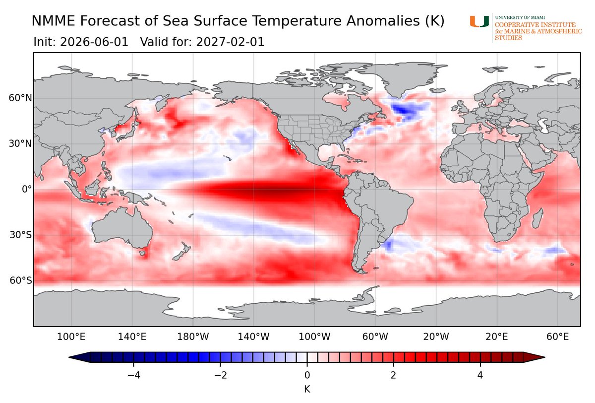
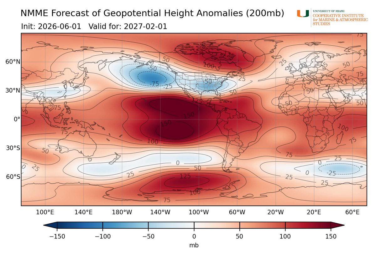
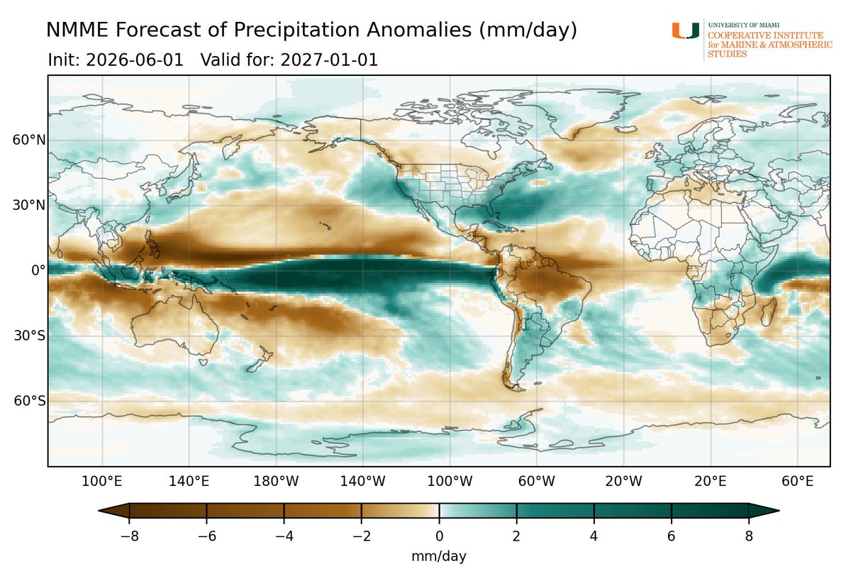
No real questions as to what will be driving the global circulation come this winter:
1
9
88
6,109
Jun 11
When Josh/Hurricane Man hath spoken, the models bow and the spaghetti plots untangle themselves😉
In all seriousness, I wrote in depth about the very scenario Josh mentions in my latest blog. Check it out: hurricanehacker.substack.com…
Jun 11

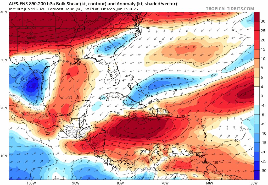
Flareup near Belize will cross Yucatan & fester in Bay of Campeche. NHC indicates 10% chance of development. Most models bring it NW to near coast of Mexico. From there, Google DeepMind models get mischievous, developing it into TS & moving it ENE, toward US Gulf Coast, Day 5-7.
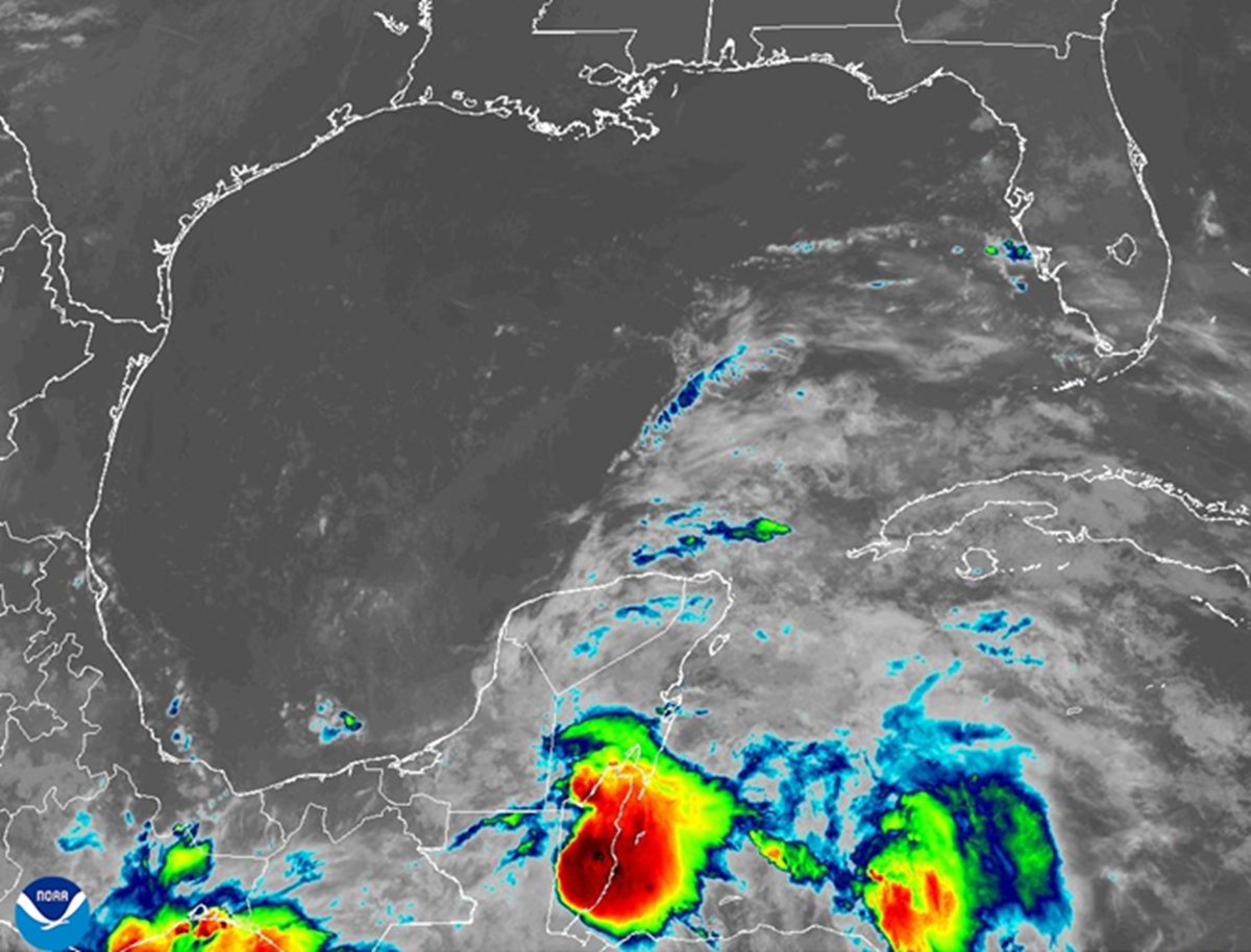
2
4
17
6,997
Jun 11
What are some of the ingredients at work here?
A stalled frontal boundary near the Gulf Coast providing vorticity, remnant energy from the TS Cristina reaching the far W. GOM this weekend and eventually dragging up lots of tropical moisture next week...
1
315
Jun 11
...Plus a pocket of lower shear in the western Gulf of Mexico next week with anticyclonic, diffluent flow.
191
Jun 5
Hurricane season could start out with a bang in the Atlantic. Reduced eastern Pacific development chances and a digging central US trough are reasons to watch the GOM carefully late next week into next weekend: hurricanehacker.substack.com…
2
12
824
Yaakov Cantor retweeted

May 6
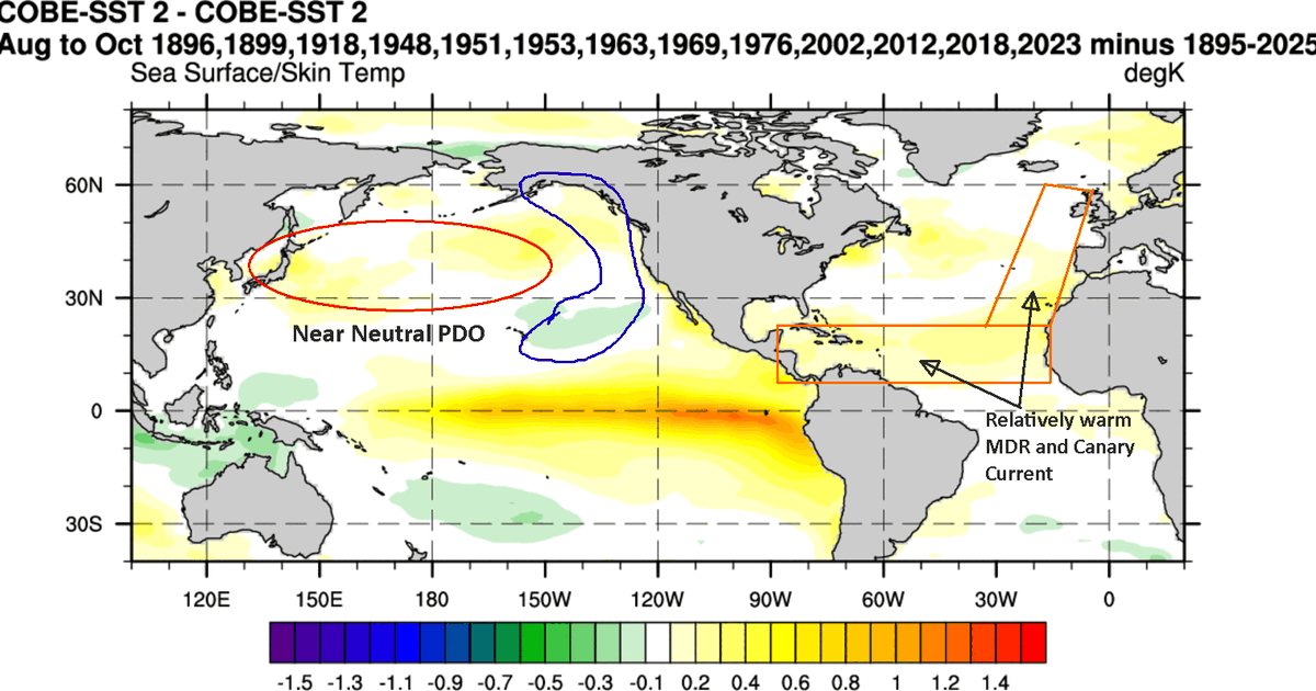
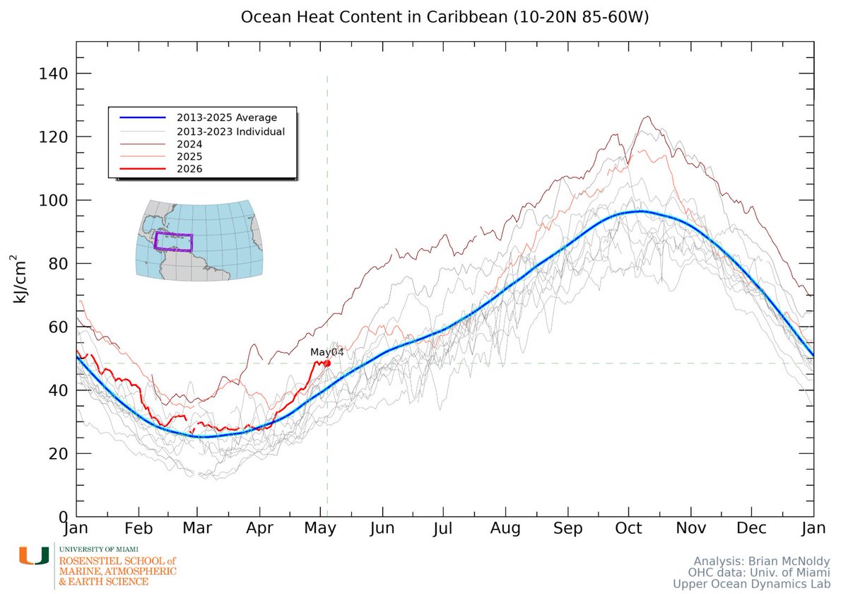
TROPICS: One of several things I am watching for is the chance of early season, 'close to home' weak tropical development before the real hostile effects of El Nino really settle in. The Caribbean is about 3 weeks ahead of typical ocean heat average. Continued dry, hot, and sunny weather in the Gulf, Bahamas, and Caribbean in the next 10-14 days will likely add to the ocean warming.
It would not be a surprise to me at all if there was an impactful weaker system or two around in the southeast U.S. pre-July 4th this year.
6
13
95
7,704
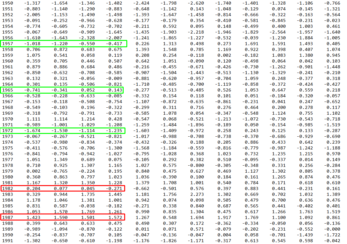
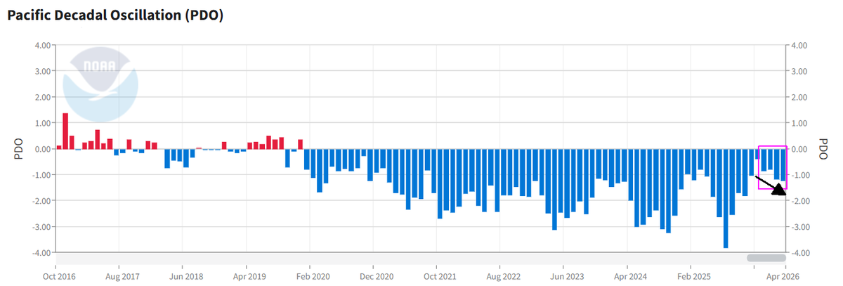
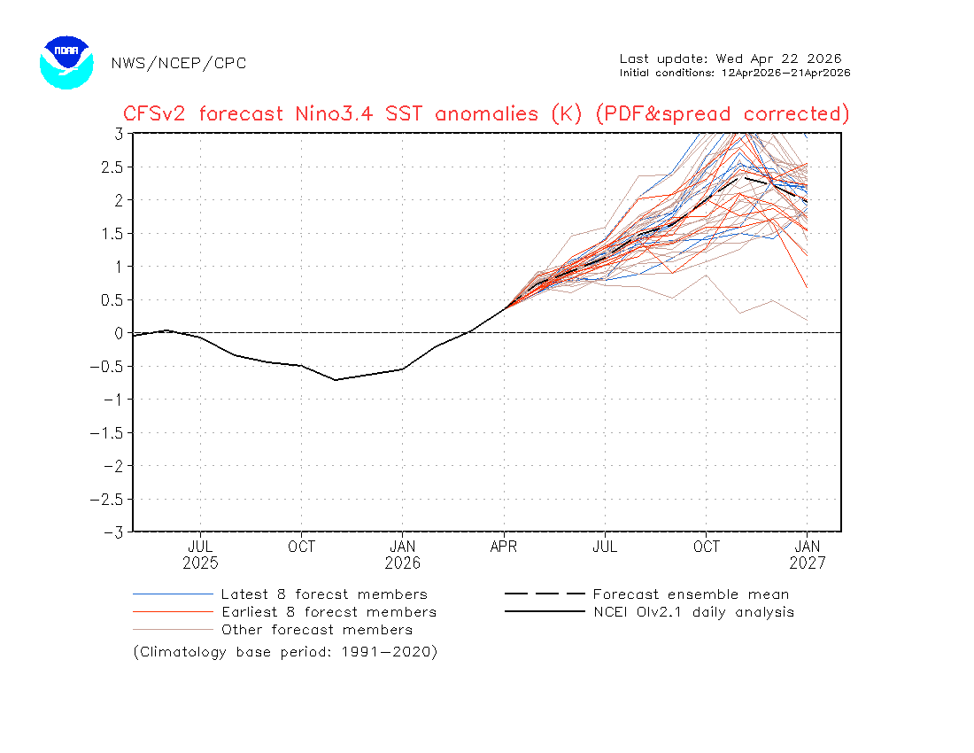
May 6
The PDO not only was highly negative in Mar/Apr, it dropped even deeper into negative values vs. Jan/Feb. Seeing such a strong -PDO/-IPO is in my view a red flag for the potential that the upcoming El Nino evolves differently than the overpowering super Nino that many expect
14
8
67
15,334
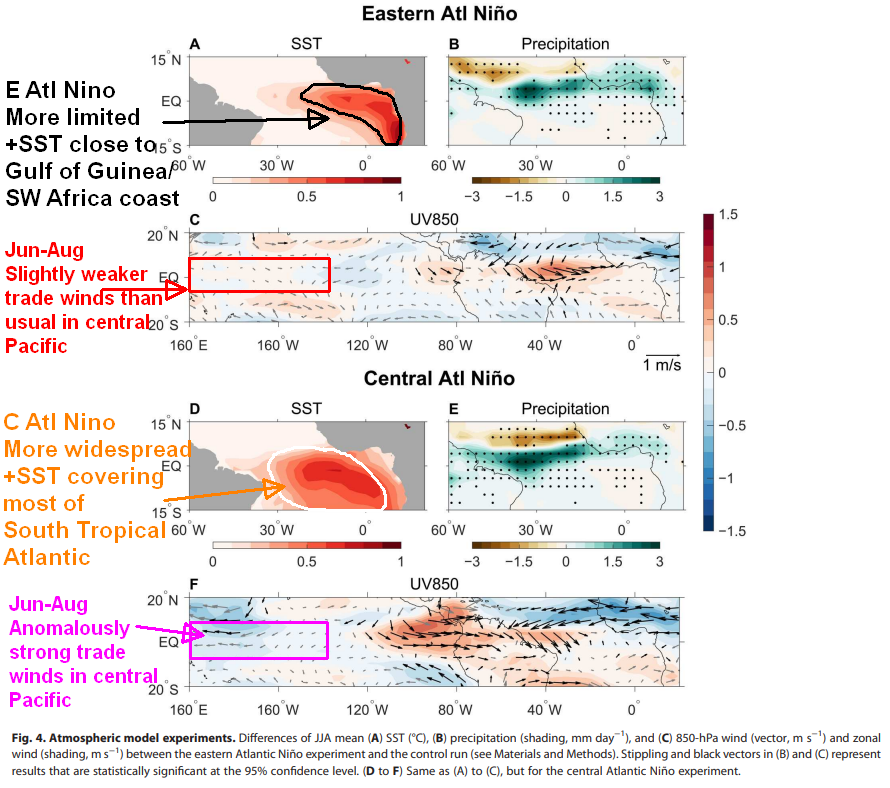
May 6
The two scenarios represent dipoles that could realistically happen this year: a strong to super Nino with overpowering atmos. coupling mainly shutting down the tropical Atlantic...
1
4
944
May 6
vs. an El Nino whose atmospheric coupling is hindered by persistent -PDO/-IPO, resulting in strong westerly upper-level winds having less impact on the Caribbean and Atlantic tropical activity more similar to "Active El Nino" years like 1899, 1951, 1969 and 2018.
1
8
913