
Joined May 2008
- Tweets 1,050
- Following 2,234
- Followers 3,324
- Likes 21,824
244 Photos and videos


Pinned Tweet

24 Mar 2025
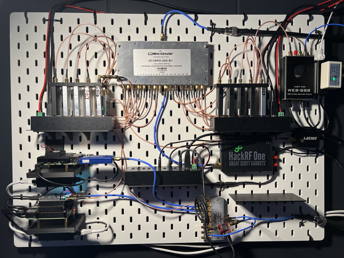
15 SDRs BTLE
BTLE/315/433/915/1090ADSB - Kismet Wireless
5 RTL-SDRs for P25 - Trunk Recorder (upload to OpenMhz)
1 RasPi4 - FlightAware 1090 ADSB
1 RasPi4 - NooElec FlyCatcher 978/1090 ADSB
1 RTL-SDR - Weather Balloon sondehub feeder
HackRF/AirSpy - SDR Server.
Web888 - FT8

14
54
453
22,128
Dustin (BusySignal-KE2EFX) retweeted

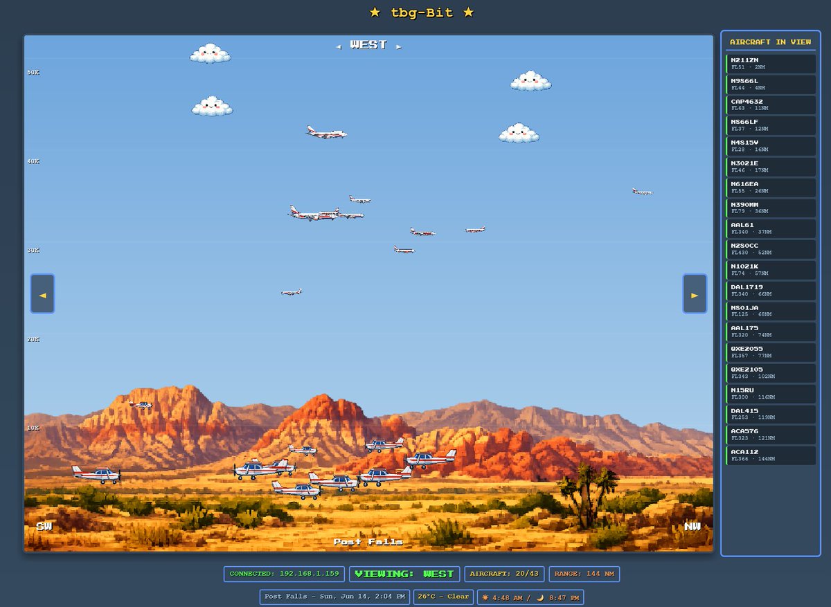
I've been waiting for this.... Finally, some vibe coded ADSB mashup that is fresh, original, and quirky fun.
Uses your own data, so you need to be self-hosting a system.
Love love love the 8-bit side view!!
github.com/AllenNPIT/ADS-Bit
3
26
1,573
dear @opieandanthony - what was the soundclip from - "its just a little joke" from?
I keep wanting to think it was one of those arthur movies of that drunk guy... but I cannot find it...
Please help.
@AnthonyCumia - anyone remember ? Bonus love for a link to a clip :)
30
Dustin (BusySignal-KE2EFX) retweeted

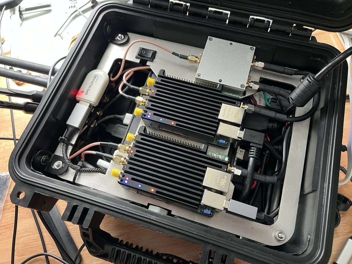
The v2 build continues to take shape: cellular uplink downlink sniffing, improved integration, and a dedicated third GPS receiver solely for GPSD duties.
3
6
134
3,295
Dustin (BusySignal-KE2EFX) retweeted

I don’t think people know what the line is anymore
173
294
8,442
1,686,329
Dustin (BusySignal-KE2EFX) retweeted

It’s 2,136 nautical miles from PHNL to KSFO, almost all of it over water.
What happens if we have an emergency?
The simple answer is that we’ll either turn back to HNL or continue to SFO, whichever is closest. To decide, we take into account the winds, assuming we have to descend to 10,000’ & drop a point where it’s an equal amount of time to either. If past the point, continue to SFO. Otherwise, turn around.
This is called our “CP” or “Critical Point”. It’s also sometimes called an “Equal Time Point”. It shifts from day to day, based on the winds, but out of the islands it’s usually at around 140° West. That’s about halfway in terms of mileage; the Coast Guard used to put a ship there in the early days, known as “Ocean Station November”. It served as a weather ship, had a beacon for navigation & was on standby for rescues at 30° North, 140° West.
(PanAm 6 did ditch near the Cutter once in 1956, with all aboard surviving)
Today, the Cutter is no longer there. Also, our CP is a little West of the mid point in terms of miles, because the winds are a light tailwind. If the winds were stronger, it would be even further West, because turning around means we have to battle a headwind now, slowing us down.
LAX is actually further from HNL at 2,217 nm, where SFO is 2,081 nm because it’s further West than LAX, so SFO is our best bet.
Hope that helps!


63
33
810
59,078
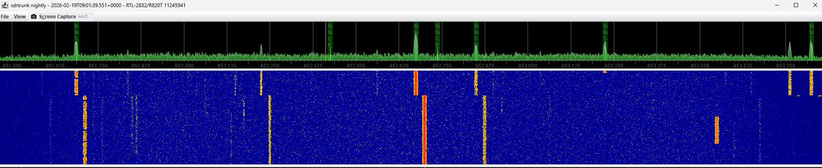
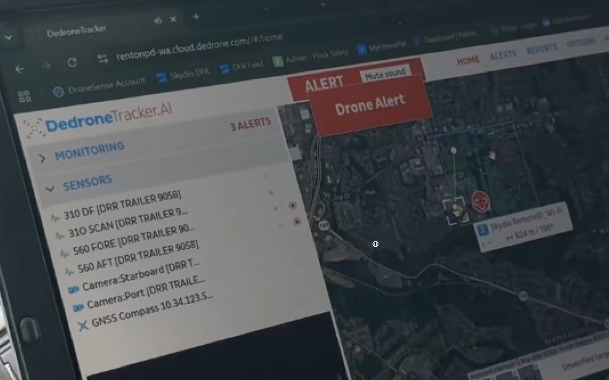
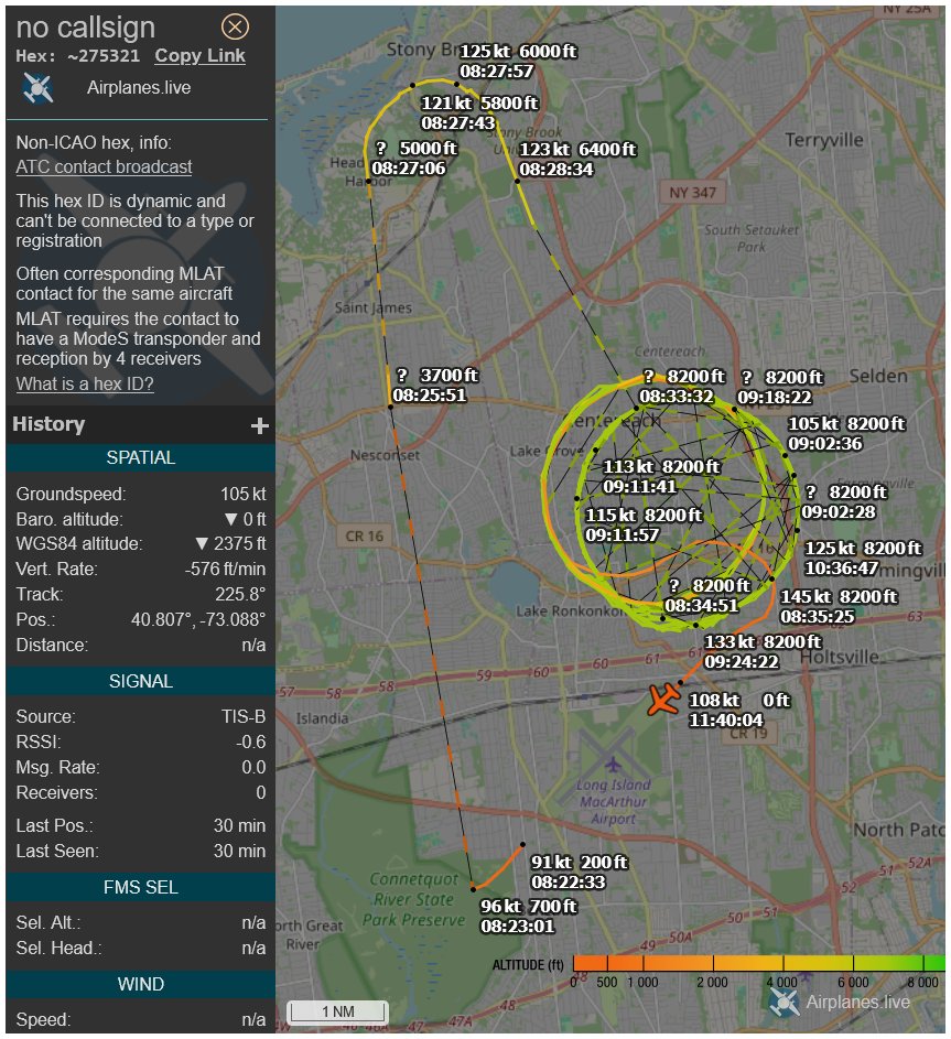
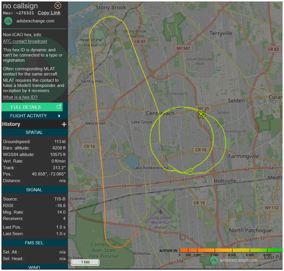
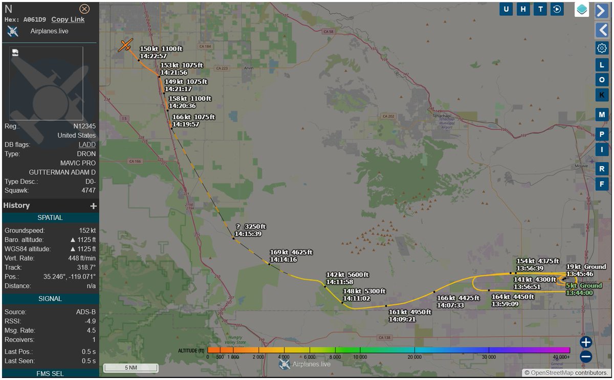
its busy in the NY and TriState area...
oh - hi there - SDR Trunk
2
59
Dustin (BusySignal-KE2EFX) retweeted

21h
good night to everyone except for the people its not night for
Jun 13

good morning to everyone except for the people it’s not morning for
71
13
400
84,533
This could be neat.

Looking to start an @offsectraining in-person meetup in NYC - if you’re interested in participating or helping out, let me know
Will be looking for presenters who are in NYC 🗽
#offsec #redteam #cybersecurity #meetup #hacker #hackermeetup #defcon #networking #cybermeetup #nyc
131
Dustin (BusySignal-KE2EFX) retweeted

Jun 13
I want to introduce you to Steve. He’s 83. His wife died a few months ago and he comes to this lodge in Spring Mill, Indiana and draws. He taught art in Terre Haute, IN his whole life. He also did courtroom sketches in court cases. In the comments I’ll share some pics from his sketchbook. He was excited when I said I was going to share his sketches with the world.

4,180
12,985
129,641
3,101,132
Quick. Send it to Washington DC.
Jun 13

Why an air purifier actually matters in your daily life at home
1
194
Dustin (BusySignal-KE2EFX) retweeted

Jun 13
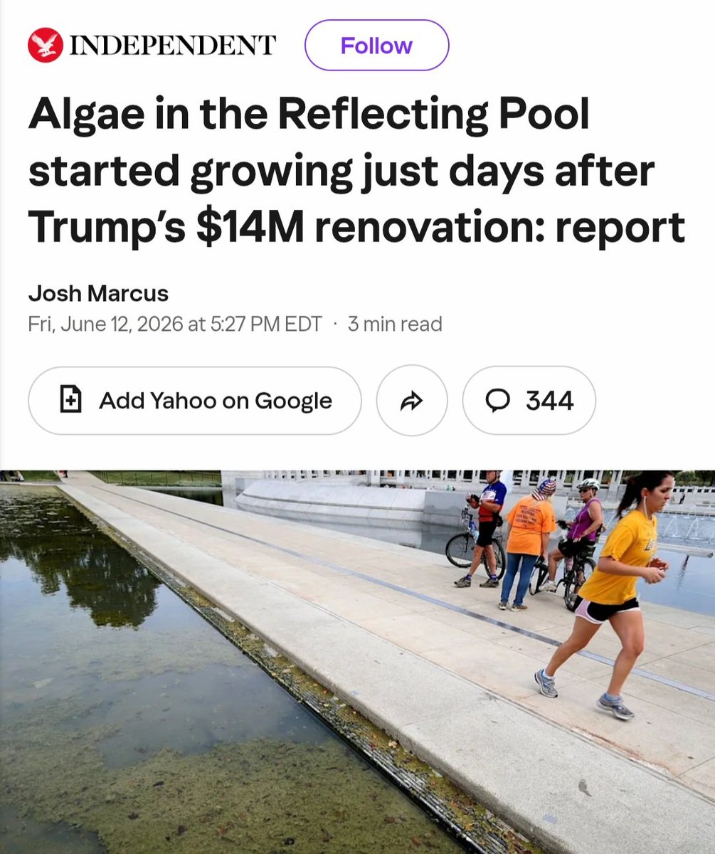
Hey, remember when those of us following and reporting on the Reflecting Pool story told trogs like Libs of Tik Tok that Trump spent $20 million on a kickback-riddled no-bid contract with an unqualified pal that would do *nothing* to fix the algae issue?
We were right.
*Again*.
28
649
1,929
24,895
Dustin (BusySignal-KE2EFX) retweeted

Jun 13
Decoding analog 5.8 GHz FPV with a HackRF
Sweeps all channels, locks a feed (not Wi-Fi or noise). Live spectrum and video recording.
Wild that a "lower-end" 8-bit SDR nails it. (It runs on any SoapySDR or UHD radio that reaches 5.8.)
Built on gr-ntsc-rc by Simon Bicais & Leonardo Cardoso.
2
32
257
11,184
Dustin (BusySignal-KE2EFX) retweeted

Jun 11
We DO NOT cut to commercials during the hydration break. Join us for uninterrupted football on @Telemundo and @TelemundoSports
Jun 11

Fox comes back late from its hydration break commercials. Unreal. Second break of the tournament and we're already missing live World Cup action.
Brutal and embarrassing.
nytimes.com/athletic/live-bl…
150
2,580
24,074
633,290
Dustin (BusySignal-KE2EFX) retweeted

Jun 12
I have a serious question for anyone at the Office of the Secretary of the Navy or the Department of War. Why are underway Sailors at Naval Station Norfolk in Virginia, many of whom are currently deployed to the Middle East for combat operations against Iran, required to pay $80 per month to the Navy Exchange (NEX) - a retail chain meant to support Sailors and their families which is owned and operated by the U.S. Navy - just to store their cars inside an overgrown, nonsecure, fenced lot? If Sailors decide not to park in the lot and leave their car anywhere else on base, they risk having their car towed, impounded, and in some cases auctioned off. How does this support our Sailors, many of whom are already struggling financially? Can something please be done about this? @SECNAV @USNavy @DeptofWar @DOWResponse @PeteHegseth

372
1,687
8,169
413,592
Dustin (BusySignal-KE2EFX) retweeted

Jun 12
Nice job! Using the high-end SDR with the uConsole was one of the reasons I made the NVMe upgrade kit.
Jun 12

In this latest demo we show LimeSDR Micro being used with a @Raspberry_Pi CM5-based Clockwork Pi uConsole and the upgrade kit from @VileerDeng, and Gqrx configured for 40 Msps.
#LimeSDR #LimeSDRMicro #LMS7002M #LA9310 #softwareDefinedRadio #SDR #OSHW #FOSS #uConsole
3
12
674
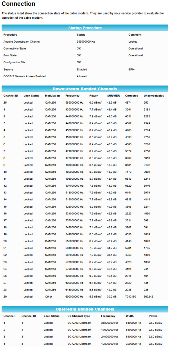
Monthly report on how terrible the @optimum @OptimumHelp service is in our neighborhood with terrible signal
2
4
688
So with very little understanding of this - can anyone explain it to me ?
Jun 11

Pre-Alpha Release: xng 0.10.1
Announcing the first pre-alpha release for the public to learn, experiment and use xng, a next-generation multi-mode decoder client.
We've been working on a single binary, multi-decoder client for a long time. We tossed most away, and then got sidetracked with other things, only to come back again and again.
We think we have it this time:
- Rust language & features
- core-based approach to decoding
- legacy support wrappers
- Airframes as 1st Class, full support for anyone else
- flexible licensing (MIT & APACHE)
There is so much to say about this pre-release. But I'm going to save it for the die hards to inspect more closely. We'll elaborate in more detail to the rest of the community as a 1.0.0 becomes closer.
Please give us feedback directly via DM, or on the repo via Issues.
github.com/airframesio/xng
github.com/airframesio/xng/r…
@alerts @updates @airframes-contrib @airframes-contrib @airframes-dev @airframes-mod
1
92
Who’s on first …
What is on second.
I don’t know.
Third base.

What Stage Schedule Update: Four Tet will now perform until 10:30 pm. Skrillex will begin at 11:30 pm.
If you are in an area without power, we are actively working on restoring power. Thank you for your patience, and standby for an update soon.
96
Dustin (BusySignal-KE2EFX) retweeted

Jun 11
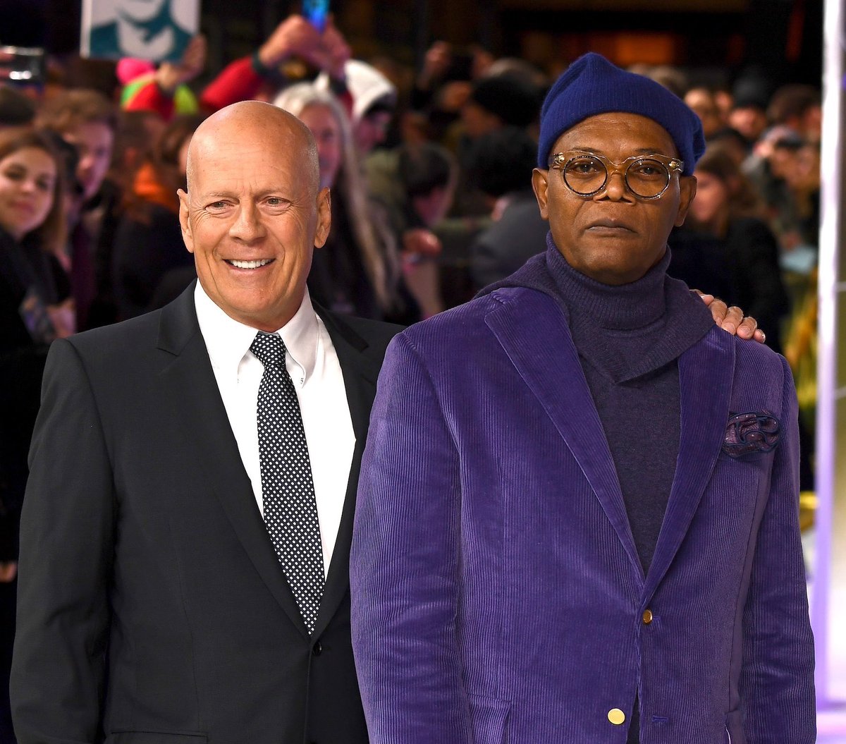
Bruce Willis told Samuel L. Jackson to find a recurring role "everybody loves" so that he'd be protected from box office flops.
“Bruce told me, 'Hopefully you’ll be able to find a character that, when you make bad movies and they don’t make any money, you can always go back to this character everybody loves,'" Jackson remembers. "He said, ‘Arnold’s got Terminator. Sylvester’s got Rocky and Rambo. I’ve got John McClane.’ I’m like, ‘Oh, okay.’ And it didn’t occur to me until I got that Nick Fury role—and I had a nine-picture deal to be Nick Fury—that, ‘Oh, I’m doing what Bruce said. I’ve got this character now.'”
122
760
29,174
2,622,013