
Lead Solutions Architect at HYFIX
Joined May 2025
- Tweets 2,226
- Following 971
- Followers 161
- Likes 2,555
Photos and videos
Chris Campbell retweeted

Jun 11
El software por encargo se acabó.
Un tío le pidió a Claude Fable un mapa de San Francisco y la IA construyó una ciudad viva: relieve, niebla y transporte real con datos reales. Un HTML de 1.2 MB, sin librerías ni internet. Corre offline para siempre.
9
30
216
29,015

Getting ready.
We partnered with @HyfixAI to launch a kickstarter for GEO-SWARM - a fully autonomous drone-in-a-box powered by @GEODNET's RTK network.
We still have a bit of road ahead of us, but we're excited with the progress and can't wait to share where we're at.
Follow and see updates here:
kickstarter.com/projects/hyf…
Learn more about GEO-SWARM here:
kickstarter.com/projects/hyf…


4
13
107
2,977
Chris Campbell retweeted

We scanned the existing property using Gaussian Splatting, rebuilt the entire renovation project in 3D, and brought it to life in @playcanvas . Explore the project floor by floor and step inside the future home through an immersive interactive experience.
3
11
158
8,681
Chris Campbell retweeted

Jun 12
Prepare for takeoff. ✈️ Flight simulator is now available globally on web to all users. goo.gle/4fBYnWO
We've recently added many our most powerful professional desktop features to web. Elevation profiles, new import types, but there's always been one other feature you've been asking us to add to the web version of Google Earth, just for fun...
Where will you fly? Share your best maneuvers, views, and flyovers with us!
446
4,009
31,069
9,121,908
Chris Campbell retweeted

Jun 12
Putting @claudeai Fable to work across my #rstats packages.
First up: implementing syncing for more than two maps at a time in mapgl's `compare()`.
Shown here: six @Mapbox themes (day, dawn, dusk, night, monochrome day & night) in perfect sync showing a 3D Vatican City.
One line of code after you initialize the maps.
2
34
2,780
Chris Campbell retweeted

Jun 11
1 Billion Gaussians (1,035,804,128 exactly) streaming to the viewer at 60fps (vsync) and 5GB VRAM.
There is no limit anymore to how much it can do.
Some need a billion dollar corp to make similar things happen, others need paid pseudo influencers without skills and knowledge to make your software look bad because someone is shitting his pants.
LichtFeld Studio is a product of love and passion. So help support this project by donating to it.
1B training on a single RTX 4090 will fall next.
Ply -> rad took 28min which is not optimized yet. There is in general some more room for optimization.
The dataset is just a 2x2 tile provided by:
3D scanning data created and provided by Andrii Shramko, TELEPORTOUR.
Links in comment to the dataset provider!
13
36
378
31,110
Chris Campbell retweeted

Gaussian splats are captures frozen in time — not anymore. ⚡
Experimental RELIGHTING of splat scenes in the @playcanvas engine, driven by a proxy mesh: swap the sky, drag the sun with its soft shadows, drop in point lights — all live on a captured scene.
🔗 Runnable demo👇
6
39
312
12,464
Chris Campbell retweeted

Jun 11
We’re proud that Niantic Spatial was selected for the In-Beta Programme by Hatch, the innovation center of Singapore’s HTX, to explore how frontier technologies could support future public safety applications.
Our work with Hatch explored how 3D reconstruction can create a shared spatial canvas for visualization and remote assessment, while our Visual Positioning System (VPS) can anchor people and machines to the same environment. These assets can also become training data for future real-to-sim workflows.
We're excited to keep exploring its potential for public safety. From faster incident understanding, to better human-machine coordination, to better preparation for the future.
#PhysicalAI #PublicSafety #SpatialAI #Robotics #EmergencyResponse #NianticSpatial #Singapore #Hatch #HTX #AI #VPS
1
4
24
7,800
Chris Campbell retweeted

Jun 9
GeoLibre v0.9.0 is out.
GeoLibre is a lightweight, cloud-native GIS platform for visualizing, exploring, and analyzing geospatial data across desktop and web environments, with a responsive layout for mobile screens.
This release turns GeoLibre into a far more complete analysis environment. Highlights:
- New cloud data panels for Microsoft Planetary Computer and Google Earth Engine, plus an Overture Maps plugin and federal Web Services plugins, including NASA Earthdata, USGS National Map, EPA EnviroAtlas, FEMA NFHL
- Accessing 1000 NASA Earthdata layers with a few simple clicks
- Time Slider plugin for animating time series raster and vector data
- SQL Workspace: run DuckDB Spatial SQL directly against loaded layers, local files, and remote URLs, with query history and one-click "add results to map"
- Conversion tools: Vector to GeoParquet, CSV to GeoParquet, and Raster to COG, running in the browser with DuckDB-WASM
- Controls menu with Measure, Bookmark, Minimap, View State, and Print
Everything is open source. Try it in your browser, install the desktop app, or self-host it.
Live demo: viewer.geolibre.app/?url=sha…
GitHub: github.com/opengeos/GeoLibre
Feedback and contributions are welcome.
#GIS #Geospatial #OpenSource #MapLibre #DuckDB #WebGIS #GeoLibre
10
130
784
41,089
Chris Campbell retweeted

Jun 10
🚧 Not every “closed road” is really closed. For fleets, even one false closure can mean unsafe detours, unstable ETAs, and last‑minute decisions.
HERE platform updates help keep routes on highways and ETAs reliable. Data accuracy makes the difference. t.her.is/3RzR9sc
4
8
871

Chris Campbell retweeted

Jun 9
Gaussian Splats are now live in Apple Maps, across all platforms.
Seems limited to selected areas , and the rendering looks like a mix of photos, meshes, and splats.
Easily one of the biggest Apple Maps updates in a while. Looks super cool.
7
43
668
66,643
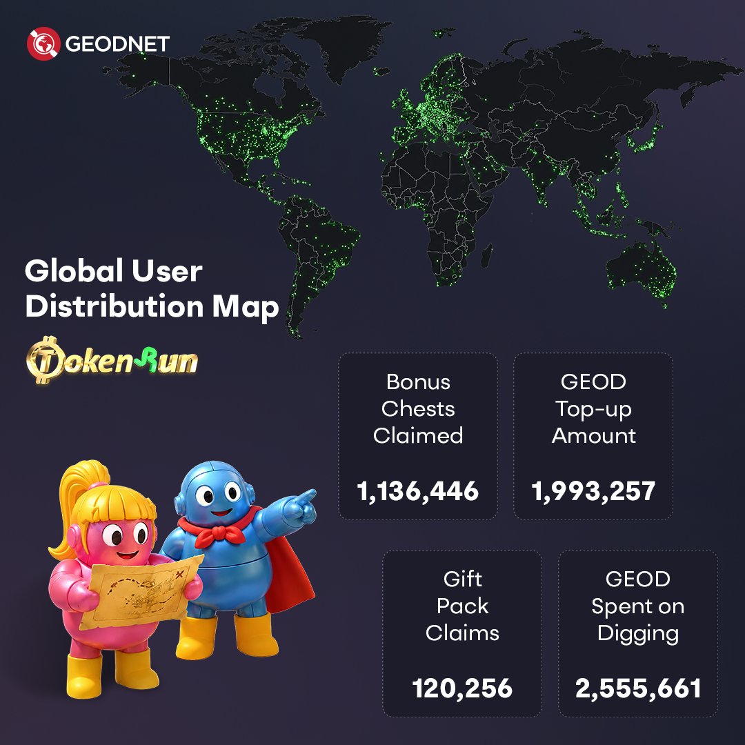
TokenRun launched globally and the community showed up.
Players are active across every continent, using real-world locations to explore, compete, and earn!
tokenrun.app
5
6
60
1,759
Chris Campbell retweeted

The future of transportation is being trained right now.
Every mile driven = more real-world data, more spatial intelligence, more capable AI.
#ROVR #ADAS
May 17

“It's a little freaky not to have a driver,” says @AndersonCooper as he rides in a Waymo robotaxi. cbsn.ws/4ut1Hb6
123
2
10
799


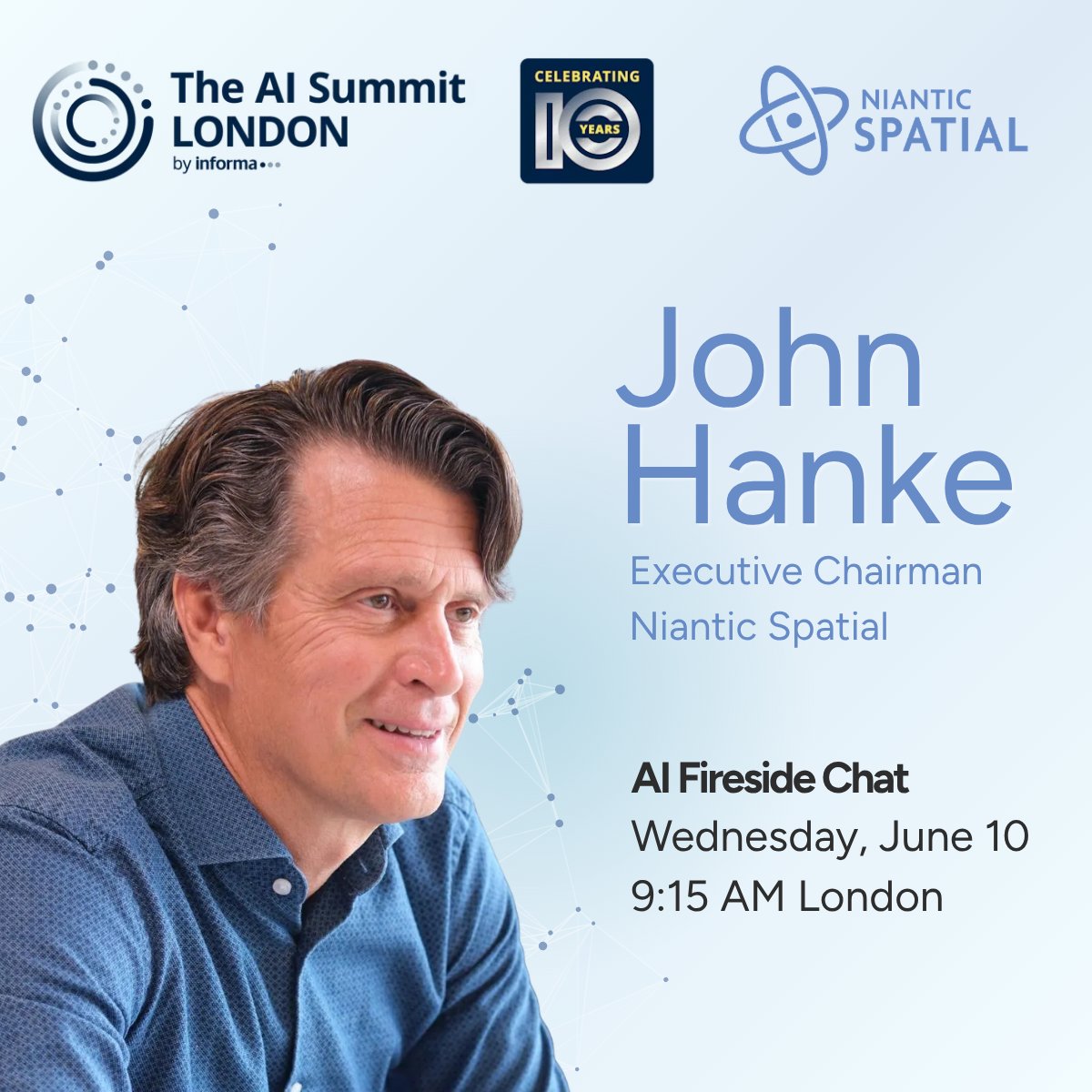
Chris Campbell retweeted
Jun 10
AI is leaving the cloud and starting to walk the streets.
At #AISummit London 2026, Niantic Spatial Executive Chairman, @johnhanke joins @zac_rash (@CocoRobotics), and Dr. Stephanie Hare (@BBC) to discuss why spatial intelligence and world models are becoming foundational to Physical AI and robotics.
From robots navigating cities to AI understanding the real world, the future of intelligence is spatial.
Learn more:
hubs.ly/Q04kQMr20
#NianticSpatial #AISummit #LondonTechWeek #PhysicalAI #Robotics #WorldModels #AI
1
3
15
7,686
Did you know?
With GEO-MEASURE 1.0.5 now released, we want to share some of the most common questions we receive about the product.
Here in Question #8, we break down how to read RTK Fix specifications, what the status bar is actually telling you, and how to catch ambiguous results before it costs you.
Read on for the answers. 👇


9
52
1,258

Chris Campbell retweeted

Apple just announced gaussian splatting is coming to Apple Maps at WWDC.
25
157
2,593
256,422
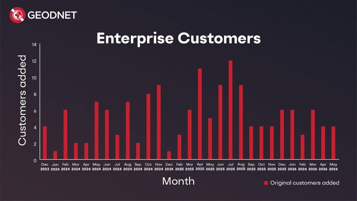
2.5 years of consecutive enterprise customer growth.
Every bar on this chart is a new organization paying for centimeter-accurate positioning. government agencies, agriculture, robotics, construction, logistics.
The positioning layer for physical AI is not a future story. it's already being bought.
8
9
92
4,216