Sat 8 am EDT: We are still watching a broad area of low pressure over the southwestern Gulf with a 20% chance of formation during the next week. For more tropical information, check out hurricanes.gov or your local forecast at weather.gov
8 PM EDT Wed, 6/10: A broad area of low pressure could form over the Bay of Campeche on Friday from a westward-moving tropical wave located over the NW Caribbean Sea. Environmental conditions are forecast to be only marginally conducive (10% chance) for development, and the system should move inland over eastern Mexico by late this weekend. Follow the latest at hurricanes.gov
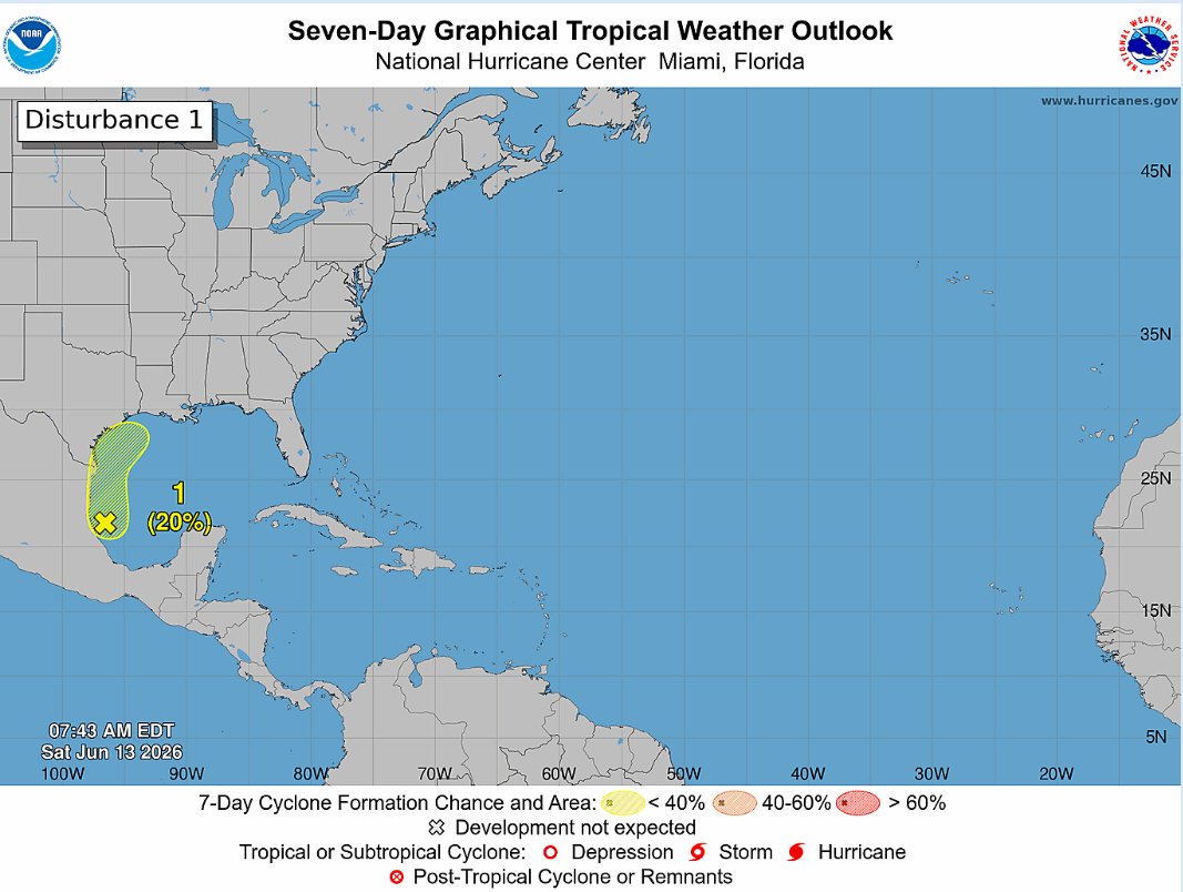
ALT Seven-Day Graphical Tropical Weather Outlook. Disturbance 1: A yellow X is highlighted over the northwestern Caribbean and is forecast to move into the Bay of Campeche by Friday, where there is a 10% chance of formation within the next 48 hours and the next 7 days.
It was a chilly morning across central NC! Raleigh-Durham Airport broke a daily record low temperature of 48 degrees. The previous record was 49 degrees set in 1956. #ncwx
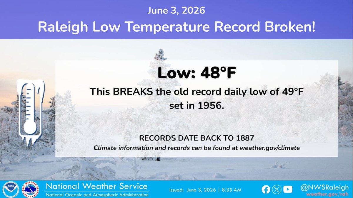
ALT A graphic showing that Raleigh-Durham Airport had a low of 48 degrees this morning, which set a new daily record low temperature. The previous record was 49 degrees set in 1956.
Here is the full break down!
*Watch for slow moving storms*
*Air you can wear starts to move in late Friday night for the Metro and areas south. *
*Saturday looks like it will be the worst day with multiple rounds of rain through the day...Humid*
*Rain continues Sunday afternoon
Is it heat exhaustion or heat stroke?
🥵 During hot and humid weather, your body's ability to cool itself is challenged in ways you may not expect.
Know the symptoms of heat exposure and what to do before summer starts. Bookmark weather.gov/safety/heat-illn….
The National Hurricane Center is testing its communication systems for the upcoming hurricane season. While we prepare our systems, please take time to prepare your home and family. Determine your risk and develop a plan today: noaa.gov/hurricane-prep
Even warmer tomorrow with some locations east of the mountains reaching into the lower 90s! #ncwx#scwx#gawx
ALT Image showing the highs for tomorrow, May 17, 2026 across the western Carolinas and northeast Georgia. Highs will range from the mid to upper 80s across the mountains and the upper 80s and lower 90s east of the mountains.
ON THIS DATE, 55 YEARS AGO: Widespread severe thunderstorms brought numerous reports of wind damage and large hail over the foothills and Piedmont of the Carolinas.
#scwx#ncwx
A few scattered showers will move into the region early afternoon into the early evening. Everything will remain on the light side before Tuesday brings bright sunny skies. Next front moves in Wednesday. #NCWx
A wildfire burning in the Everglades near the Broward/Miami-Dade County line has grown to 4,800 acres and remains 0% contained as it approaches US-27.
🎥: @FLStormChasers_
☀️ Today in Utqiagvik (the northernmost city in the United States), the sun rose above the horizon at 2:57 AM and won’t set again for 84 straight days or until August 2nd! Here's a look at a timelapse showing the sunset and sunrise this morning. #akwx
Effective at 8 a.m. Friday, May 8, the N.C. Forest Service has lifted a ban on all open burning for 19 additional counties in NC. Read news release: bit.ly/4tRpqBE