
Joined August 2018
- Tweets 76
- Following 24
- Followers 137
- Likes 65
19 Photos and videos


LifeInGIS retweeted

19 Apr 2023
Discover how Shamba is using #blockchain technology to enhance sustainable farming practices through our ecological data oracle system. Check out the latest article by @egreechee on @coindesk and join the movement towards a more sustainable future.
coindesk.com/consensus-magaz…
1
16
34
2,953

27 Feb 2023
Here are some tips to grow your #GIS development skills
lifeingis.com/effective-tips…
51
LifeInGIS retweeted

26 Jan 2023
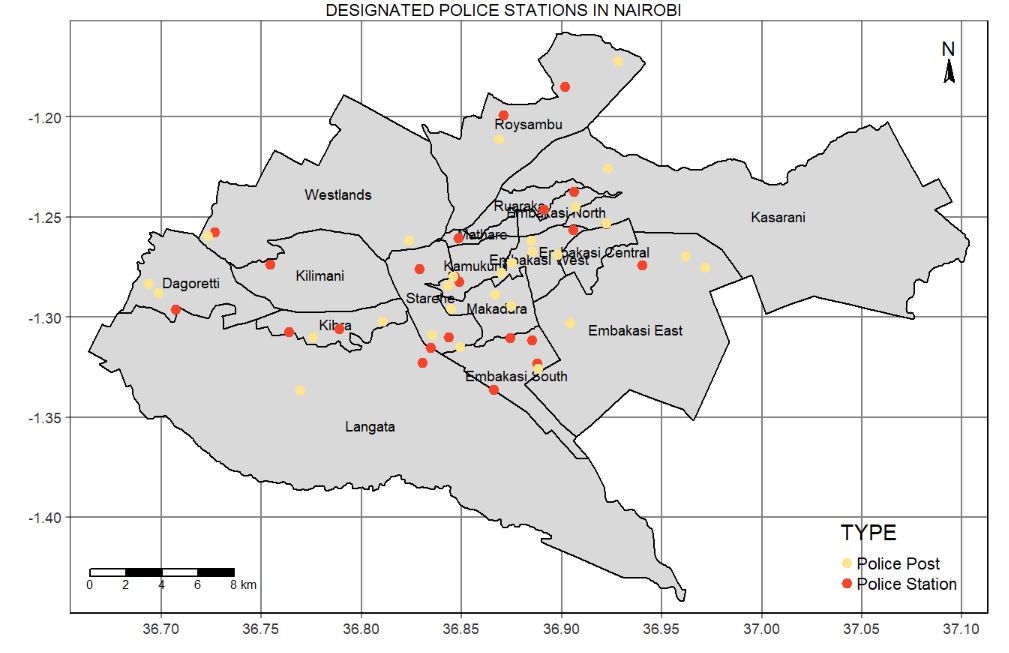
I created this map using #R .. Interesting to see the kind of visualization that the #tmap package can do..From analysis to visualization all was achieved through #automation ..Our main focus was to map the designated police stations in Nairobi County
#gischat #geospatial #R
11
62
2,990
7 Dec 2022
Wondering what best #free #mapping #software exists today? Have a look at the list lifeingis.com/which-is-the-b…
LifeInGIS retweeted

13 Nov 2022
Why does an industry of trustless systems keep trusting in sociopathic scammers?
A fair question.
Every time we prioritize short term price over long term values it always catches up with us.
To go forward we must go back.
Back to decentralization.
103
72
502
LifeInGIS retweeted

4 Nov 2022
On farm trials in Bomet and Kericho confirms that soil testing for diagnosis on plant nutrient levels for fertilizer recommendations based on the soil test is very important. Specific Soil testing methods used are critical. For more info; Tukutane NAR field day on 9th & 10th Dec


6
6
LifeInGIS retweeted

8 Sep 2022
@ShambaNetwork by @KennedyWNganga is building a DMRV platform that leverages geospatial data and AI to make MRV affordable and accessible even for small-scale projects. Their goal is to provide the data that underpins regenerative finance projects across the global south.
1
3
16
LifeInGIS retweeted

11 Jul 2022
This looks quite useful for training classifiers and deep learning models in #GEE. @samapriyaroy would be a good dataset to have for the community catalog. mlhub.earth/datasets?search=…
11 Jul 2022

Radiant Earth is excited to announce the release of LandCoverNet, the first global multi-satellite training dataset for land cover classification. #LandCoverNet will enable the creation of high-resolution & up-to-date maps for natural resource management bit.ly/3nVxdhE
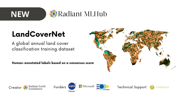
ALT LandCoverNet is a human-annotated training dataset with images from Sentinel-1, Sentinel-2, and Landsat 8 satellite missions to support natural resource management in Africa, Asia, Australia and Oceania, Europe, and North and South America.
2
5
39

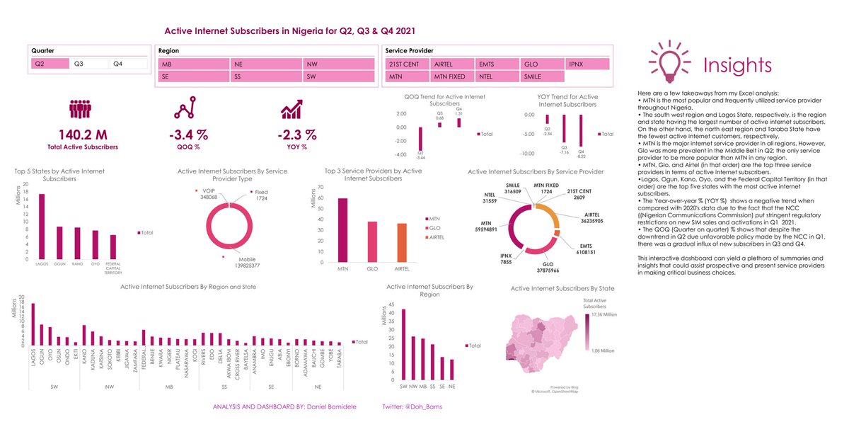
Hello #Datafam, Here's my first official dashboard using Excel where I analyzed the data for Active Internet Subscribers in Nigeria for Q2, Q3, and Q4 of 2021.
The data was collected by the Nigerian Communications Commission and published by the National Bureau of Statistics.
13
14
98
LifeInGIS retweeted

8 Jun 2022
I'm speechless...
can't really get my head around half-million downloads and 4.8 ratings!
thanks all for helping making me the best and most used fieldwork app possible!
Do you want to help?
qfield.org/donate
qfield.org/contribute
#dataisoutside #fieldwork #gischat
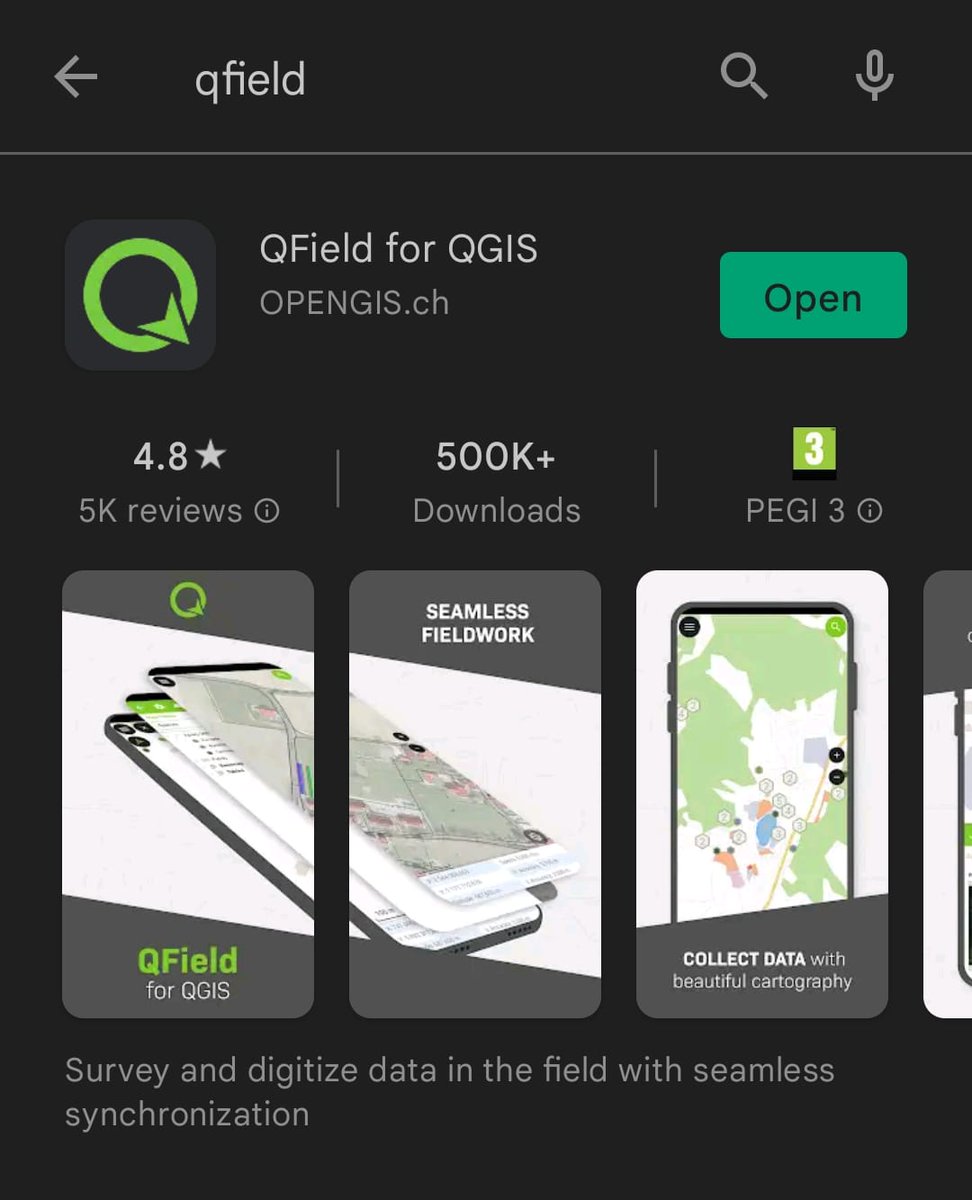
ALT QField reacher the 500K downloads mark
1
30
172
LifeInGIS retweeted

1 Jun 2022
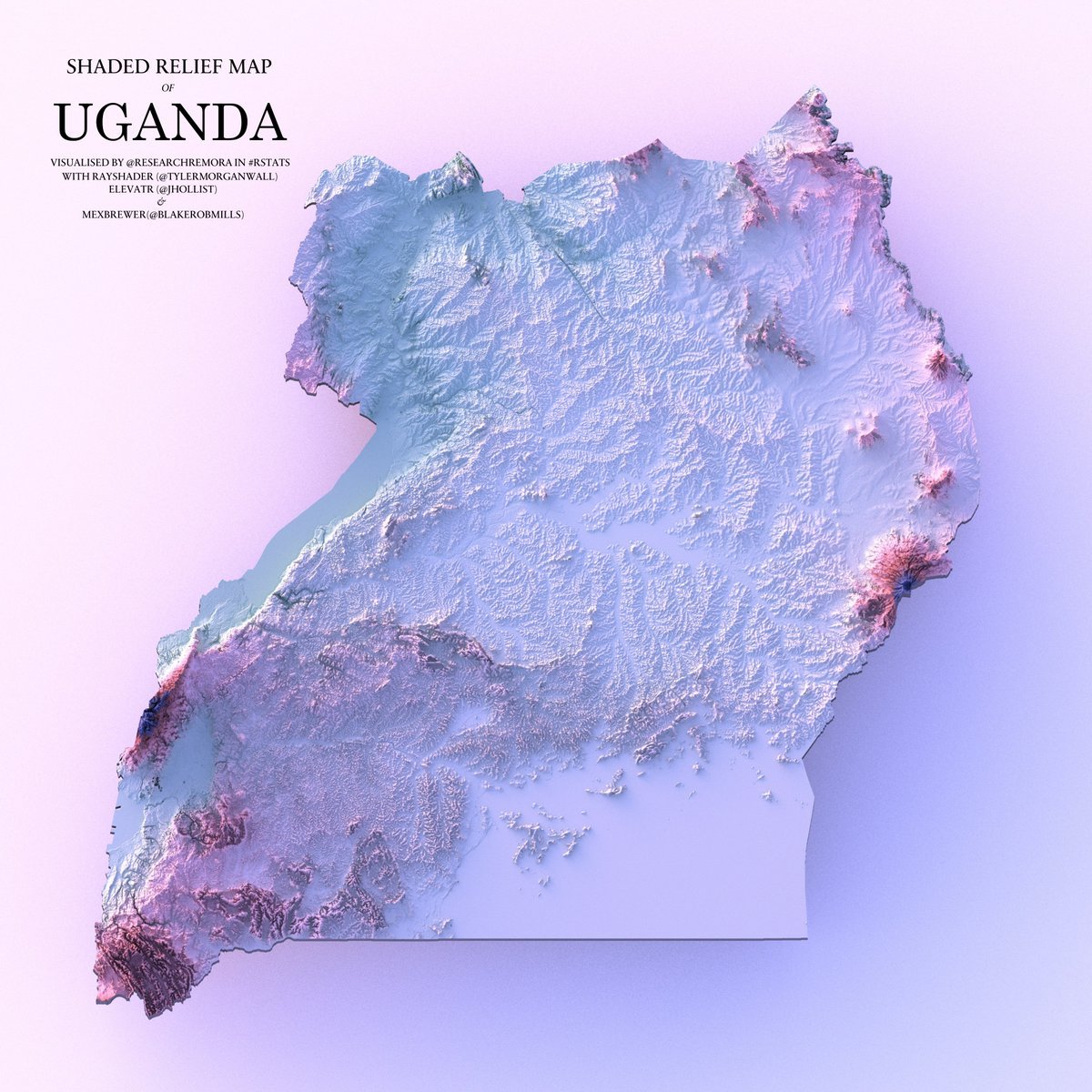
A shaded relief map of Uganda.
#rayshader adventures, an #rstats tale
4
27
133
LifeInGIS retweeted
29 May 2022
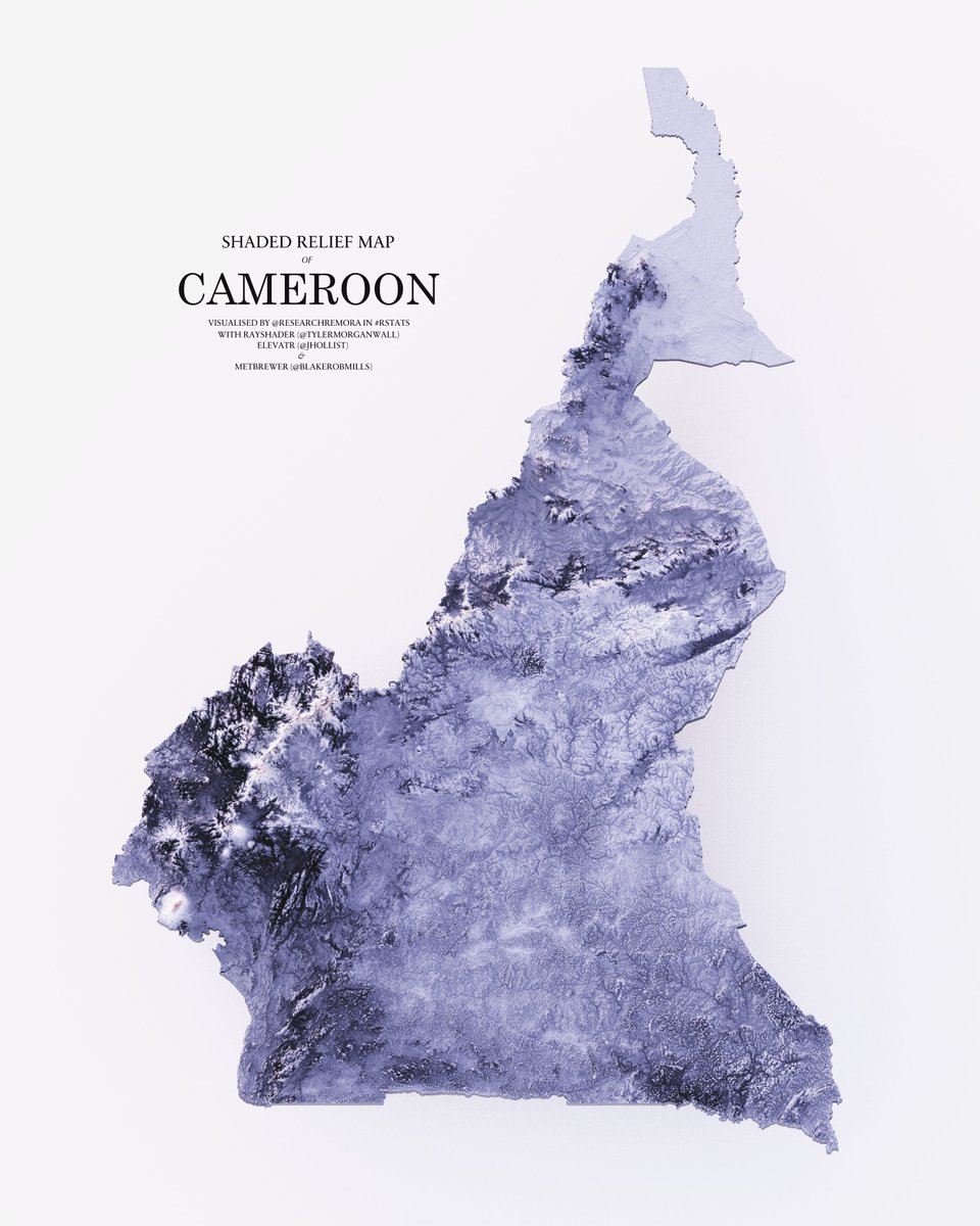
A shaded relief map of Cameroon.
#rayshader adventures, an #rstats tale
18
130

6 May 2022
New post (GIS for Gender Equality: An Outlook) has been published on Life in GIS - is.gd/uujlhx
1
LifeInGIS retweeted

3 May 2022
I'm currently creating a new course for geospatial professionals and enthusiasts, "Introduction to Google Earth engine". Stay tuned for more updates
Are you excited 😁 ? #gischat
Don't forget to subscribe to my YouTube channel.
1
14
48
LifeInGIS retweeted

29 Apr 2022
The current extreme #heatwave in #Pakistan and #India as seen today, on the fourth intense hot day, by #Copernicus #Sentinel3 LST (Land Surface Temperature, not Air!). LST collected on April 29 shows max value exceeding 62°C/143°F. Gaps due to cloud/snow/nodata. #ClimateEmergency

218
2,517
6,242
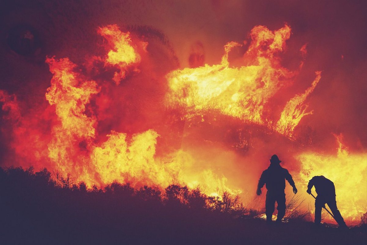
23 Apr 2022
New post (Post-Fire Hazard Detection (ALOS-2 & Landsat-8)) has been published on Life in GIS - is.gd/SCYB89
21 Apr 2022
New post (Ensemble Methods in Machine learning) has been published on Life in GIS - is.gd/Gcbo24
1