
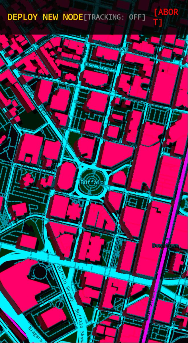
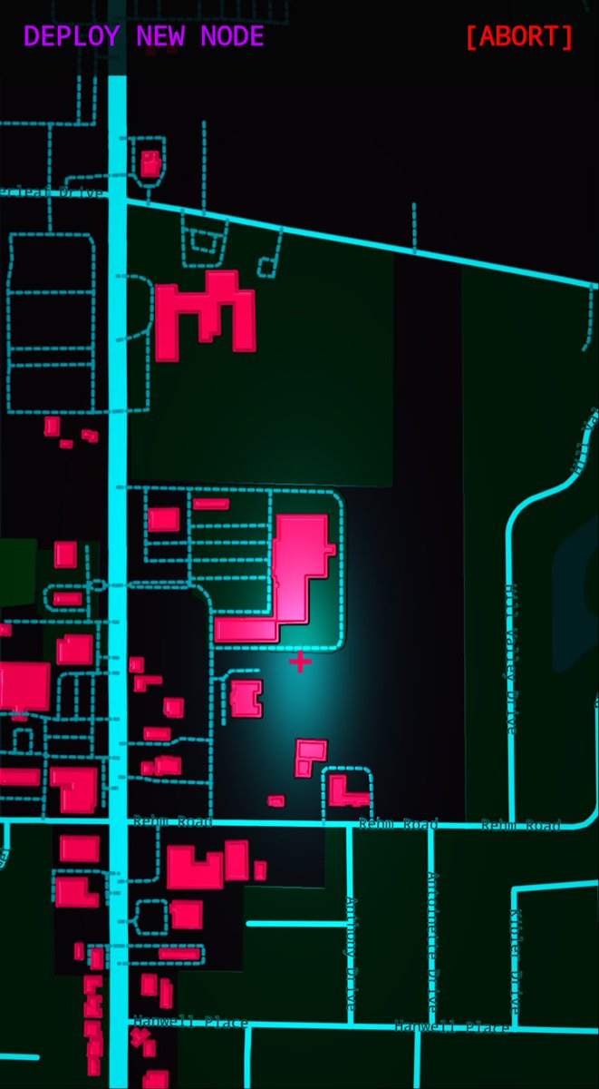
Think I found a look and feel that works very well from a distance or zoomed in. Still just Mapsforge with a little shader magic applied and a custom theme.
Tracking was also added, it just hits the sensor to update our position like any other map app continuously rather than on open.
53
Faking a height map with shaders is alright.. might want to take a different approach. Since mapsforge is CPU bound I have to rework the pixels as displayed with shaders. Far less room to work with than even my watch face creations.
I *could* ask a bot to assist with creating an engine for this.. not sure I really want to put in that much effort. I'll just make that global light follow the user around and tune it a bit so it doesn't look as hamfisted and vibed.
21
Offline maps are done using Mapsforge, still working on a flow to assist users with pulling down their specific state/region. Anytime you add import functionality you have to perform a few additional steps to ensure the user isn't going to get hurt. For a local build including it with the APK is relatively bulletproof. That cannot happen here so securing that import pass is going to take some effort.
Already decided that sharing your list of locations is going to be needed, at least for a backup process. This is another import headache that likely will be solved with my map import solution. Straying a bit from my experience so this might take a while.
36


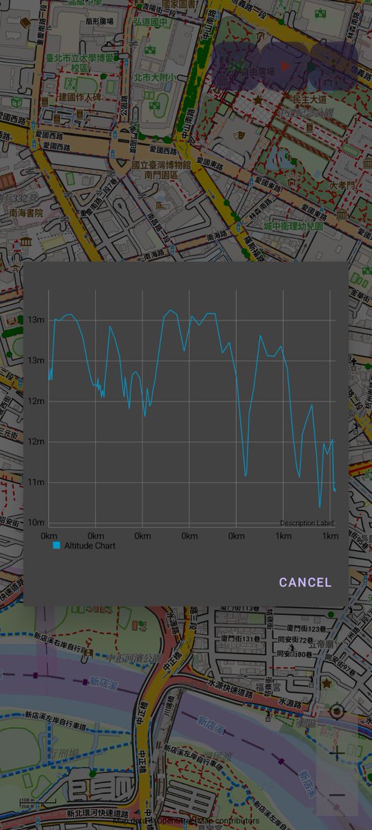
即使使用了氣壓高度,仍因讀取到的壓力的變化,讓高度看起來波動很大
然後想到魯地圖中已經包含了Dem高程資料,我可以用GPS經緯度查找當前高度,應該會比較準確而穩定
Mapsforge中支援Dem,其Dem class為DemFolderFS
再用demFolderFS.getElevation(latitude, longitude)
#魯地圖 #Dem #Mapsforge
2
34

12 Dec 2025
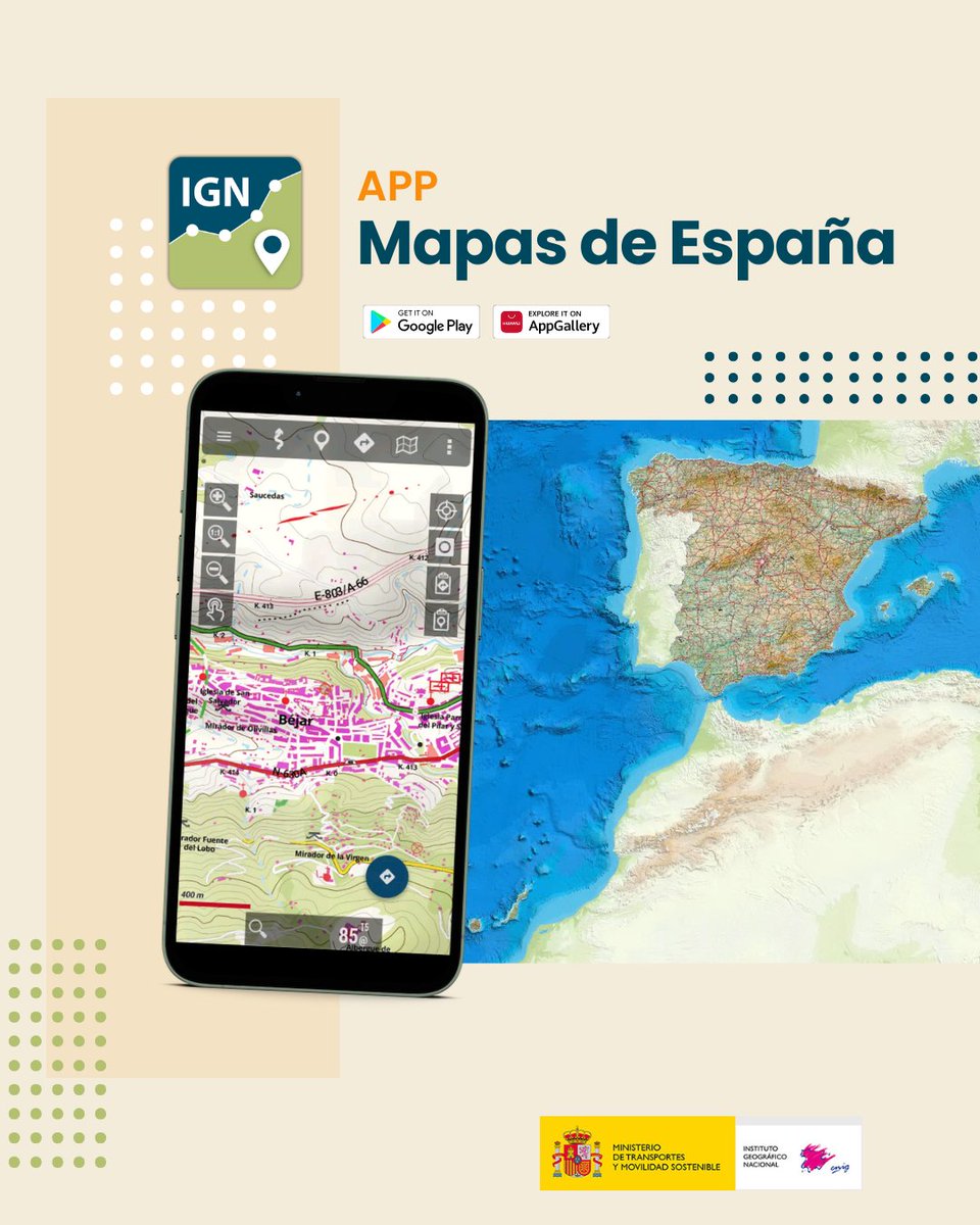
📍 Novedades en la app #MapasdeEspaña
✨ Nuevos idiomas: euskera, gallego y catalán.
📂 Mejor gestión de almacenamiento.
♻️ Conservación de archivos al desinstalar la aplicación.
🗂️ Administrador de rutas mejorado.
📤 Compartir rutas de forma individual o por grupos.
📍 Compartir waypoints sin necesidad de guardarlos.
🧭 Nuevo “Radar hacia waypoint objetivo”.
🗺️ Actualización de librerías Mapbox y soporte de mapas Mapsforge.
#IGNSpain #CNIG #App #Cartografía #Senderismo @transportesgob
1
6
13
1,323
在地圖風格上掙扎很久,因為魯地圖現在多加了緊急避難所跟共想單車圖示,整個很凌亂,AI都說要修改風格檔,可是別的程式也是直接下載魯地圖,而且可以選擇要顯示的種類
昨天終於發現有一個Callback,只要把想顯示的Categories回傳就可以
#Mapsforge
17
下載進度條-好幾天
存儲種類-一個禮拜
指南針-一天
地圖縮放-程式庫自建,無段一直沒搞定
GPX記錄-一個禮拜
等等..等等..
地圖程式庫這麼龐大真要摸到熟沒有一年就別想了
#mapsforge
14

WRPElevationChart Ver. 2.0.66 for Android released. Now with DEM data support when using #Mapsforge offline maps play.google.com/store/apps/d… #Android #chartmaker #freeware #gpx #apps #gps #gpstrack #software #visualization #3d #3dchart #mapsforge #offlinemaps
3
107

14 Jul 2025
魯地圖主要產出是針對 Android 手機的 mapsforge 格式,所有 workflow 被 Rudy 寫在一個很大的 Makefile 裡面,對 Garmin IMG 格式的支援差不多就在第 1000行左右😎
github.com/alpha-rudy/taiwan…
44
WRPElevationChart Ver. 2.0.46 for Android released. Now with #Mapsforge offline maps support and many minor improvements.
play.google.com/store/apps/d……… #Android #chartmaker #freeware #gpx #apps #gps #gpstrack #software #visualization #3d #3dchart #mapsforge #offlinemaps
2
111

20 Feb 2025
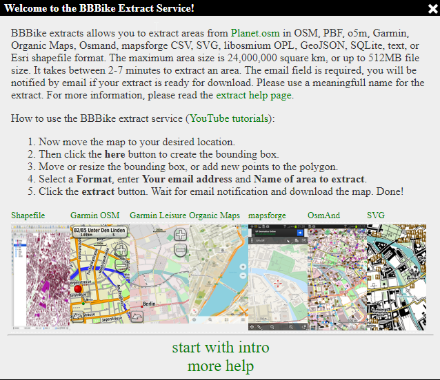
BBBike Extract Service: Free OpenStreetMap exports in PBF, Garmin, Osmand, mapsforge, Organic Maps, SVG, GeoJSON, SQLite, Esri shapefile or mbtiles format extract.bbbike.org/
2
8
54
2,613

9 Feb 2025
🌍 Dive into the world of offline maps! Learn how to integrate OpenStreetMap vector tiles in your Android app with the Mapsforge library. Customize and style maps easily without a tile server! Kudos to Mubarak Native for the insights! #OpenStreetMap #And… ift.tt/wL9EaKb
19

13 Nov 2024
Published my 2nd Rust crate mapsforge-rs.
Map header parsing is done, also trying my best to follow industry standards. next will be map tile parsing.
Crate: crates.io/crates/mapsforge-r…
Github: github.com/ChetanXpro/mapsfo…
#buildinginpublic #Rust
1
100
13 Nov 2024
For rendering maps, I am using Mapsforge maps. It's very lightweight and mainly designed for GPS systems.
I'm using Rust, both for fun and memory safety.
Since there are no libraries available to parse Mapsforge binary data in rust, I'll need to create a parser as well.
13 Nov 2024

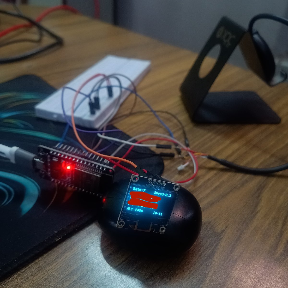
I built my own GPS tracker for just (22$) after nearly getting lost in the Himalayas last year. A shepherd helped when snow covered the trail during my solo hike.
Basic but works - shows location, altitude, time and satellites. still, lots of work is left, like map navigation
1
110

9 Jul 2024
Las distintas fuentes de mapas nos proporcionan una resolución cartográfica de imagen o topográfica para interpretar lo que tenemos por delante en un incendio forestal. Fuentes cómo:
✔️PNOA y IGN
✔️GOOGLE
✔️OSM (OpenStreetMap)
✔️Librería de mapas offline Mapsforge
Entre otras.🌍
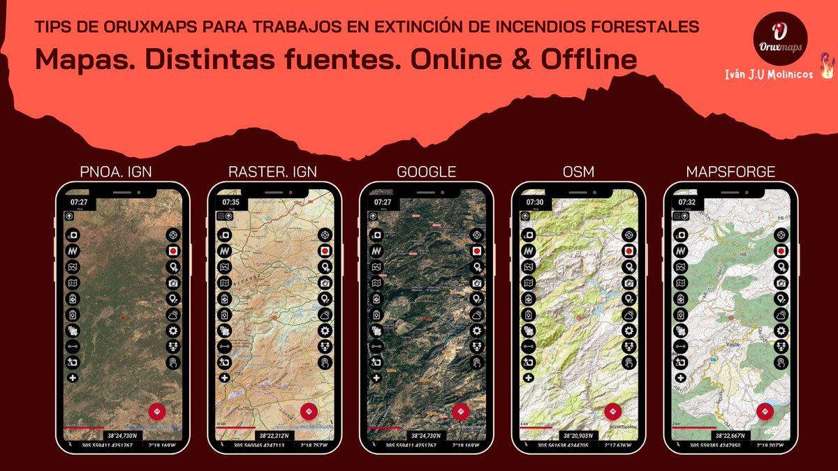
ALT Las distintas fuentes de mapas nos proporcionan una resolución cartográfica de imagen o topográfica para interpretar lo que tenemos por delante en un incendio forestal. Fuentes cómo: ✔️PNOA y IGN ✔️GOOGLE ✔️OSM (OpenStreetMap) ✔️Librería de mapas offline Mapsforge Entre otras.🌍
1
90

29 Apr 2023
#BBBike extracts areas from OpenStreetMap (#OSM) in various formats: OSM, PBF, o5m, Garmin, Organic Maps, mbtiles, OsmAnd, #shapefile, mapsforge, OPL, GeoJSON, SQLite, text or CSV . The maximum area size is 24M sq km or 1500 MB file size.
4
2
331