
Jun 9
I could have sold the city a way cheaper solution that does the exact same thing.
RemoteID can be picked up by anyone with a phone.
2
2
850

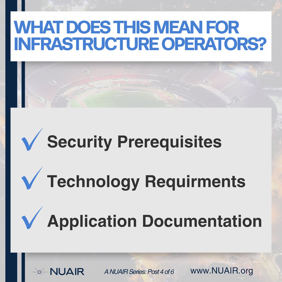
𝗜𝗳 𝘆𝗼𝘂 𝗼𝗽𝗲𝗿𝗮𝘁𝗲 𝗮 𝗳𝗮𝗰𝗶𝗹𝗶𝘁𝘆 𝘁𝗵𝗮𝘁 𝗾𝘂𝗮𝗹𝗶𝗳𝗶𝗲𝘀 𝘂𝗻𝗱𝗲𝗿 𝘁𝗵𝗲 𝟮𝟮𝟬𝟵 𝗥𝘂𝗹𝗲, 𝗮 𝗨𝗔𝗙𝗥 𝗱𝗲𝘀𝗶𝗴𝗻𝗮𝘁𝗶𝗼𝗻 𝗶𝘀𝗻'𝘁 𝗮𝘂𝘁𝗼𝗺𝗮𝘁𝗶𝗰. 𝗬𝗼𝘂 𝗵𝗮𝘃𝗲 𝘁𝗼 𝗮𝗽𝗽𝗹𝘆, 𝗮𝗻𝗱 𝘆𝗼𝘂 𝗵𝗮𝘃𝗲 𝘁𝗼 𝗯𝗲 𝗿𝗲𝗮𝗱𝘆 𝗯𝗲𝗳𝗼𝗿𝗲 𝘆𝗼𝘂 𝗱𝗼.
The proposed rule sets meaningful prerequisites. Applicants must already have layered security measures in place: restricted access controls, active security personnel, and on-site monitoring. The FAA isn't creating security infrastructure through this rule. It's recognizing facilities that already have it.
Beyond physical security, there's a technology requirement that deserves attention.
Remote ID receiving capability is a prerequisite for UAFR applicants.
Facilities must demonstrate the ability to receive and log broadcast Remote ID messages from drones operating nearby. This isn't just a checkbox. It reflects the FAA's expectation that restriction and situational awareness go hand in hand: you can't enforce a boundary you can't observe.
Additional application requirements include:
• Documentation of existing drone traffic patterns near the facility
• Identification of specific facility vulnerabilities
• A description of potential consequences if those vulnerabilities are exploited
Part-time designations, relevant for seasonal facilities like amusement parks, are capped at 290 consecutive days per year.
For facility operators who've been waiting on this rule for years, the path forward is now defined. The question is whether your security posture and technology stack are ready to support an application.
𝙉𝙚𝙭𝙩 𝙐𝙥: 𝙒𝙝𝙖𝙩 𝙩𝙝𝙚 𝙧𝙪𝙡𝙚 𝙢𝙚𝙖𝙣𝙨 𝙛𝙤𝙧 𝙐𝘼𝙎 𝙤𝙥𝙚𝙧𝙖𝙩𝙤𝙧𝙨.
#2209Explained #UAS #FAA #RemoteID #criticalinfrastructure #airspace
34

Apr 29
Better pray it was a cheap drone without RemoteID.
2
277
124,767

Apr 29
What was their FAA RemoteID number? Hobbyists are required to broadcast that from the drone. Of course if that was malicious criminal intent, they don't follow rules, laws, code, etc.... anyway
2
108

Apr 21
$ONDS will be bigger than most can imagine currently . Defense has been, and will continue to drive current multiples, but the massive, untapped multiplier is a dual-use strategy for the civilian sector.
For the (inevitable) massive civilian expansion to work, the lower skies need a digital traffic controller. I expect RemoteID to become a legal mandate, for which Ondas is the major architect (@CeoOndas knows this area well..). Think of it as the digital traffic controller for everything under 400ft.
You need constant ISR. So whether it be through the World View acquisition with $PLTR partnership or the Optimus system, Ondas is bridging the gap between tactical drone and stratospheric data collection for better C2. We’re taking always on 24/7 layered surveillance that very very few can provide.
You gotta protect critical infrastructure. This in particular is a massive dual use multiplier. The same tech used at borders for CUAS, or say even the same tech used on current demining projects, will be deployed to protect rail, utilities, oil/gas, civilian centers, and yes, data centers. Insane amount of potential here, use case is dozens and dozens, all of which will make their way through roadmaps.
And you cannot have autonomy at scale, especially across domains, without bulletproof comms. FullMax can provide wide area broadband that commercial BVLOS requires. And yes, we have the deep OTM call option that will print on the rail rail. This is a deep moat.
I see a lot of people comparing Ondas to others in the market recently. The market is going to be big enough for many winners who will be multiples higher, no doubt. But there is not someone better suited with a force multiplier than the dual-use systems of systems $ONDS is building.
And always remember, money will follow the network. It will begin to make a lot of sense.
Apr 21

The defense tech sector will create a massive amount of market cap in the next 3-5 years.
The simple math below is evidence that the cycle has just started.
Some giant companies will be built around unmanned and autonomous systems.
1
4
95
9,559

Apr 4
Nicht so spannend wenns RemoteID ist :) Das geht mit Wifi LE und Bluetooth LE damit: github.com/bkerler/DroneID (wobei es hier auch schon genug Android iOS Apps gibt)
5
774

Then @Bin4ryDigit came along and round 2 happened via CIAJeepDoors. RemoteID prototypes got folks killed in Ukraine before we stepped in. github.com/MAVProxyUser/CIAJ…
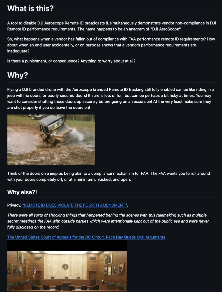

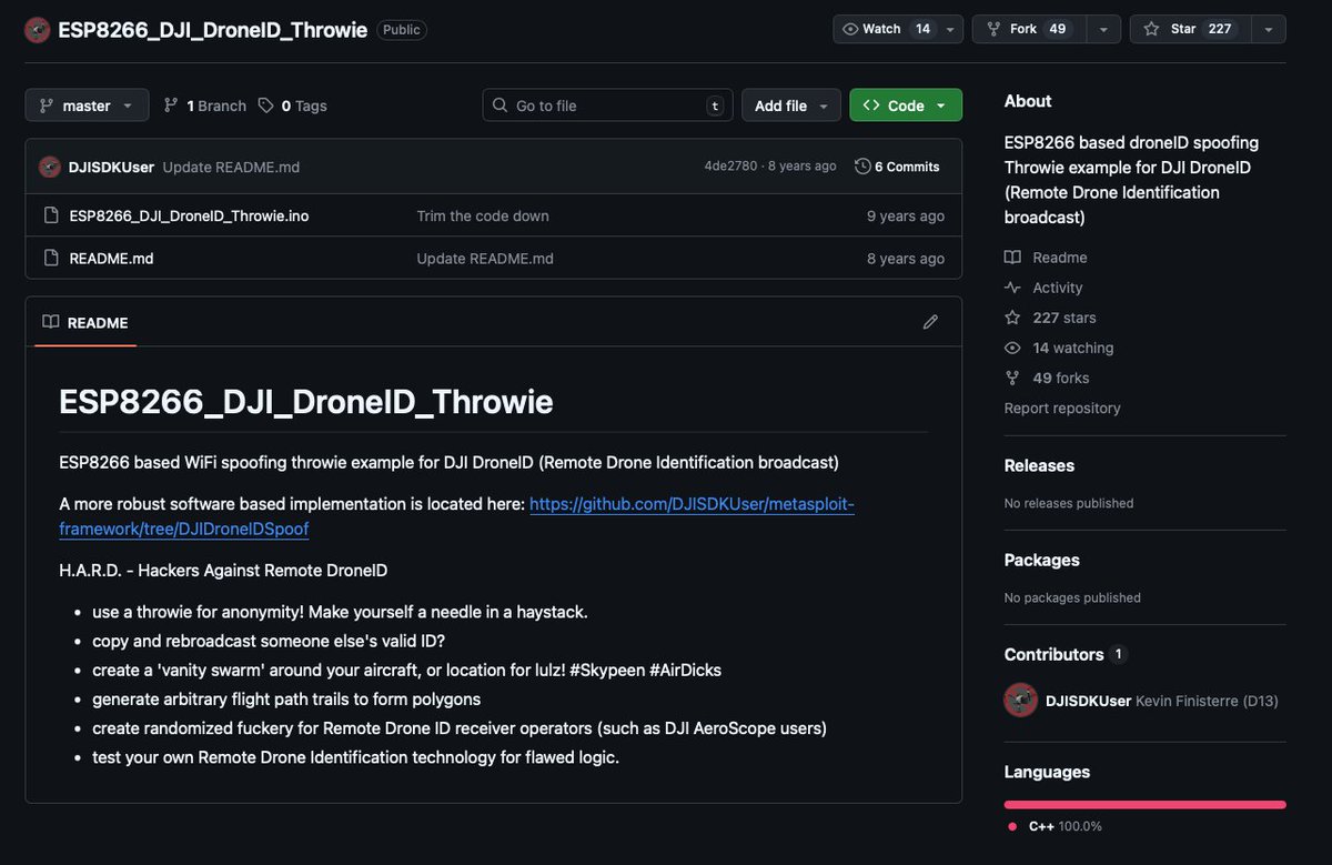
A decade ago I tried to warn you all about Remote DroneID via H.A.R.D. - Hackers Against Remote DroneID github.com/DJISDKUser/ESP826… I hear it gave @_colonel_panic some inspiration back in the day. We need Mesh-Spoofer accordingly... drop it!
1
10
2,506

True bearing based on the GPS coordinates contained in the drone-broadcast RemoteID packets relative to the detector. (I'm assuming, since it's an RID-based detector)
1
5
45

Deploy a sensor. Earn from drone data. Backed by military-grade tech. Mandated by federal law.
If you're into DePIN, infrastructure plays, or just think drone airspace is going to be a warzone of competing interests over the next decade, this is worth your attention.
Website: flitegrid.io
Docs: docs.flitegrid.io
Follow @FliteGrid
@wholovesburrito – you've been tracking sensor-based DePIN plays, think this one has legs given the regulatory mandate already in place. What's your take? 👀
Shoutout to @SuperteamEarn for the bounty.
#DePIN #RemoteID #FliteGrid
1
11
175

Mar 18
ça ne sert donc à rien sur les drones et pilotes non enregistrés ou remoteID desactivé comme ceux qui volent autour des prisons et sites sensibles ... @Thinker_View @bluetouff
ps: on apprecie le site en anglais et pas en français !
3
2
552

Mar 16
Not financial advice. Just pointing at a law that created demand, a company with a decade of contracts, and a sensor network that doesn't exist yet nationwide.
Follow @FliteGrid. #DePIN #FliteGrid #RemoteID
18
77

Feb 27
DJI owns 26 of the EU’s 66 approved drones — nearly 40% — but that dominance might not matter: EASA is rewriting the Cx class and the EU may force mandatory Remote ID at 100g.
That could reclassify tons of consumer drones and spark major industry pushback this summer. #RemoteID
(1/2)
1
1
2
447

Feb 12
The nodes are sensory nodes, they detect and report to a C2 Command Center, in C2 you get alerts/events on whats happening. The C2 can send external triggers to counter systems. So yes the nodes are only monitoring, they do not interfere with any signals. ☺️, also the drone detection is limited to FAA based drones that emmits RemoteID. We may develop other detection methods in future nodes/stations.
1
5
352

🚨EXPOSING The Turning Point USA "Make Heaven Crowded Tour '"As A Surveillance Trap — Documentary & Counter-Tech Operation
THE MISSION: April 8, Philadelphia. April 13, Virginia Beach. Two "Make Heaven Crowded" events in seven days. We are deploying custom-built surveillance detection technology to expose exactly what is happening to attendees. Then, we will release a documentary style film exposing our journey, pitfalls, findings,everything on film for the audience to see.
WHAT WE'RE BUILDING:
The "Ghost Protocol" Detection App We are developing a mobile application that transforms your phone into a military-grade surveillance detector. This tool is designed to uncover the invisible digital net cast over these events:
IMSI Catcher Detection: Exposes fake cell towers ("Stingrays") harvesting your phone data, call records, text messages, and location.
Geofencing Analysis: Maps the invisible digital boundaries used to track attendee movement and identity.
Network Monitoring: Identifies data interception, connection hijacking, and SSL stripping attacks in real-time.
Drone Surveillance: Decodes aerial RemoteID broadcasts to reveal operator locations, flight patterns, and camera activation.
RF Spectrum Analysis: Detects command signals to identify AI-controlled swarm patterns vs. manual piloting.
Real-Time Logging: Captures evidence to encrypted servers, ensuring data is saved even if local networks are compromised.
THE PLAN:
@danksterintel and @Project Constitution are traveling cross-country with cameras, gear, and detection equipment to find hard proof of our research. Our investigation suggests that Turning Point USA (TPUSA) is functioning as a massive, CIA-style surveillance apparatus.
We believe they are using geofencing, data interceptors, and drones to map physical characteristics—gait, ears, facial structure—to build biometric profiles on every attendee. This data is allegedly being used to spy on, analyze, and target individuals with custom-tailored propaganda, while being shared with the US government through the SkyFoundry Act to create a mass database of conservatives.
The Operation: We will go undercover for seven days straight, hitting at least two major events. We will document the deployment, capture the data, analyze the findings, and release the documentary film to the world.
THE REALITY CHECK:
This is experimental. We don't know what we'll find.
The app might detect a full-scale surveillance operation.
It might detect nothing.
Technology can fail in field conditions, and targets can adapt.
But nobody else is doing this. Nobody else is building the tools to expose it.
BUDGET BREAKDOWN - $20,000 TOTAL
FIELD OPERATIONS: $7,200
Hotel Accommodations: $1,750 (7 nights for two investigators).
Travel: $800 (Flight to Philadelphia) $400 (Gas for cross-country equipment transport).
Logistics: $950 (Operational vehicle rental) $250 (Tolls/Parking).
Event Access: $400 (Tickets for both Philadelphia & Virginia Beach events).
Subsistence: $1,400 (Food & supplies for 7 days).
Contingency: $1,250 (Emergency resources for security).
TECHNICAL INFRASTRUCTURE: $6,500
Detection Hardware: $3,200 (RF receivers, spectrum analyzers, ruggedized mobile monitors).
Server Infrastructure: $1,200 (Encrypted backend, secure evidence storage, 12-month hosting).
Development: $800 (Software licensing, testing platforms).
Security: $500 (VPNs, encrypted comms tools).
Backup Systems: $800 (Redundant storage, field-replaceable components).
PRODUCTION & DOCUMENTATION: $4,300
Equipment: $2,000 (Camera systems, audio gear, stabilization).
Post-Production: $1,200 (Editing software, rendering, professional polish).
Legal: $800 (Consultation for operational compliance).
Archival: $300 (Long-term evidence preservation).
FUTURE OPERATIONS: $2,000
Buffer Fund: Resources to expand coverage to additional tour stops if findings warrant it, replace damaged hardware, or deploy extra investigators.
(Any funding in excess of what is needed for this specific project will go directly toward future investigative projects.)
WHY THIS AMOUNT?
Two major events in five days requires serious operational capacity. We are not cutting corners. Professional-grade detection equipment costs real money, and secure infrastructure isn't free. The $2,000 buffer gives us flexibility: if Philadelphia reveals something major, we have the resources to immediately expand coverage at Virginia Beach.
WHAT YOU GET:
ANY DONATION: Free lifetime access to the Ghost Protocol App when released (Commercial Value: $200-$500).
$50 : Behind-the-scenes documentary footage & field updates.
$100 : Beta app access raw surveillance data logs from both events.
$250 : Private video briefing on findings early documentary screening.
$500 : Executive Producer credit direct consultation call with Danks.
$1,000 : All of the above exclusive access to full technical documentation, code repositories, and methodology guides.
TRANSPARENCY GUARANTEE:
We will publish full expense reporting after the operation, including receipts for every purchase and video documentation of the deployment. If we raise more than needed, excess funds go directly into additional event coverage or will be refunded proportionally to donors (based on a donor poll).
THE TIMELINE:
NOW - MARCH 31: Fundraising, app development, equipment acquisition.
APRIL 1-7: Final testing, travel to Philadelphia, operational setup.
APRIL 8: Philadelphia Deployment (Data Collection).
APRIL 9-12: Analysis, travel to Virginia Beach, continued monitoring.
APRIL 13: Virginia Beach Deployment.
APRIL 14-30: Data compilation, documentary production.
MAY: Film Release & App Public Beta Launch.
WHY THIS MATTERS:
If they are running surveillance at revival events, Americans deserve to know. If data is being harvested from attendees, you deserve proof. If drones are mapping crowds and tracking individuals, you deserve to see the evidence.
We're building the technology. Making the trip. Documenting everything. Releasing it all. No corporate funding. No compromises. Just receipts.
DONATE NOW - GET THE APP - SEE THE TRUTH
👉🔗spot.fund/8fx1l3tst
68
224
741
2,410,211

19 Dec 2025
$ONDS
@JeffGabel and I chatting RemoteID…
On that thought for the bulls one thing that isn’t talked about enough.
The Safer Skies Act and Remote ID didn’t come out of nowhere.
Eric Brock wasn’t just reacting to these rules. He was involved years ago through the Commercial Drone Alliance or CDA, helping shape how regulators thought about identification, accountability, and enforcement.
That’s why today’s framework looks the way it does. Remote ID as a baseline.
Layered enforcement for non-compliant actors. Non-kinetic, civilian-safe solutions.
Ondas didn’t build toward the rules.
They helped anticipate them.
Feels obvious now. It wasn’t then.
LongAF $ONDS
19 Dec 2025

Bro how did I miss that original post! This is definitely the right framing. Remote ID is going to be the license plate of the skies It’s one of those things that’s necessary but not sufficient. Infrastructure only works when enforcement still functions after “plates” are removed. I think that’s the shift happening now.
Airspace moving from “who’s flying” to who’s accountable and who can be stopped. Feels like we’re finally treating the sky the way we treat roads, rails, and ports.
And this extends well beyond drones really. eVTOL and autonomous aviation will only work if accountability and enforcement scale with the airspace.
1
38
6,347

Note that in their xmas vid, the @FAANews fail to mention that sub250g drones (which are most of the drones sold these days for recreational use) DO NOT REQUIRE REGISTRATION or RemoteID. I wonder why they've omitted that highly relevant fact? youtube.com/watch?v=LShF63yy…

12 Days of Drones
Are you hoping to unwrap a drone this year? The FAA has 12 tips to ...
youtube.com 1
4
126

10 Dec 2025
lmfao. yeah it’s gotta be registered. and have remoteID. and i had to take a certification thing.
1
2
53

🚁 #Drone incursions at critical‑infrastructure sites are rising — and #regulators are watching.
We help organisations stay compliant & protected: Remote ID, counter‑drone strategy, liability, privacy & enforcement.
#DroneLaw #CounterDrone #UAS #RemoteID #dronelawyer
2
3
82
3 Dec 2025
DJI drone owners must register drones over 250g by 2025 to avoid fines up to $10,000.
FAA, CAAS, and CAA rules now require Remote ID broadcasting and visible registration.
Stay compliant or risk grounding and penalties. #DroneLaws #RemoteID
(1/2)
1
2
519