
May 2
23
96
3,780

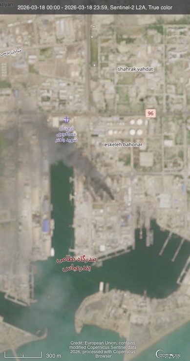
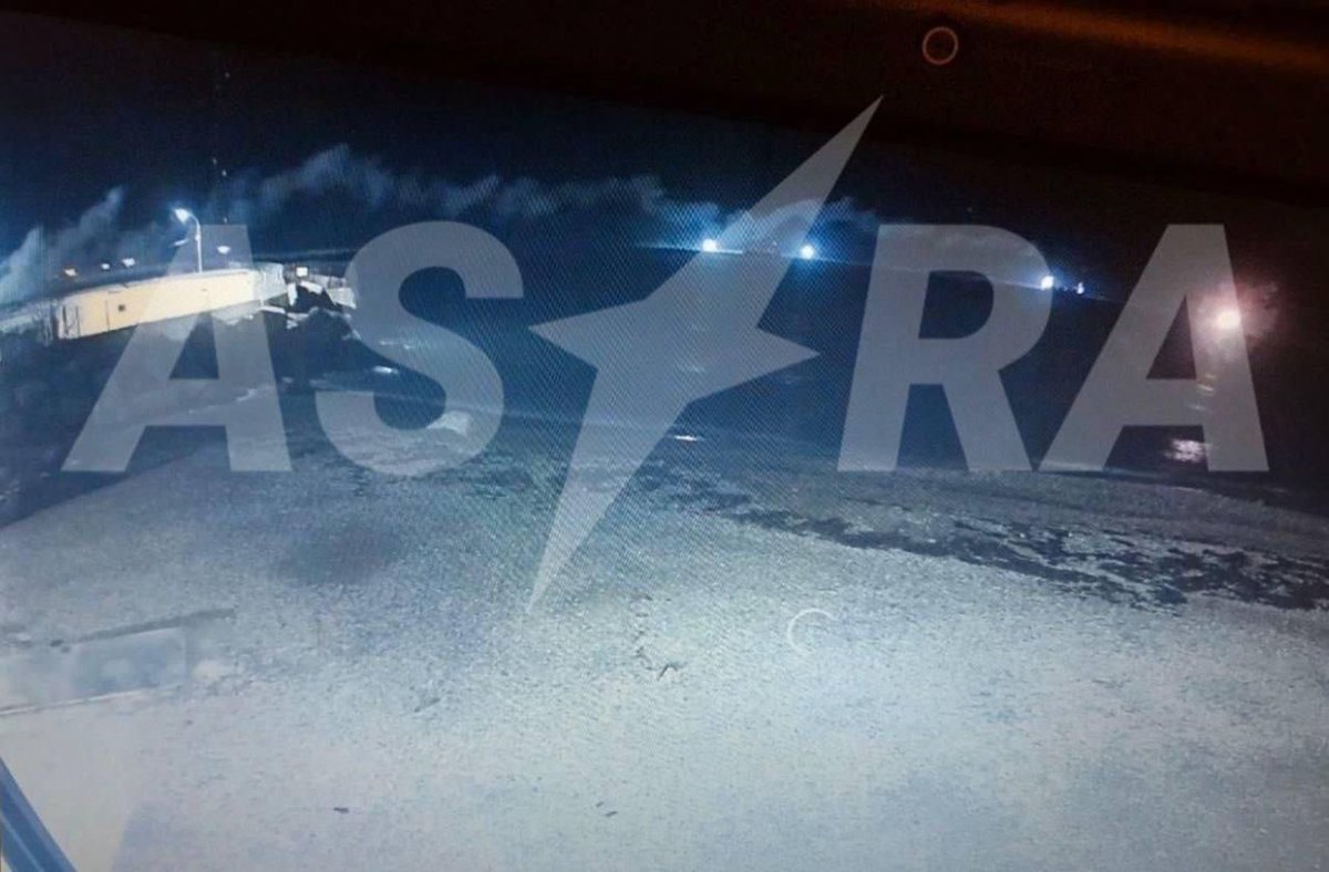
دود ناشی از سوختن سولههای بمباران شده در بندر نظامی بندرعباس.
مارچ ۱۸
تصویر: Sentinelhub
39
2,419

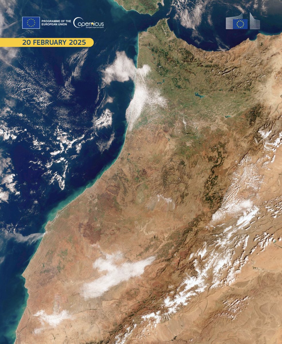
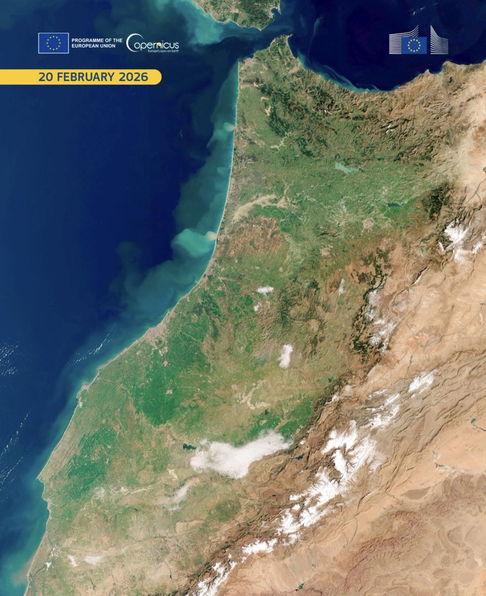
🟥 𝐍𝐨𝐫𝐝-𝐄𝐬𝐭 𝐝𝐮 𝐌𝐚𝐫𝐨𝐜 : 𝐦𝐞́𝐭𝐚𝐦𝐨𝐫𝐩𝐡𝐨𝐬𝐞 𝐩𝐚𝐲𝐬𝐚𝐠𝐞̀𝐫𝐞 𝐞𝐭 𝐫𝐞𝐭𝐨𝐮𝐫 𝐝𝐞 𝐥𝐚 𝐟𝐥𝐨𝐫𝐞. À gauche, captée le 20 février 2025 par #Sentinel3 dans le cadre du programme européen @CopernicusEU, l’image révèle un paysage marqué par une sécheresse sévère et une végétation raréfiée. Un an plus tard, le 20 février 2026, la scène opposée montre, après deux mois de pluies soutenues, un territoire reverdi et des retenues élargies. Les ressources hydriques atteignent 11,8 milliards m³ ( 155 %), les barrages 70,7 % de leur capacité. #globalimpact #Morocco #CopernicusProgramme #ClimateResilience #WaterSecurity #DroughtRecovery @sentinelhub @planet
1
7
388

Feb 15
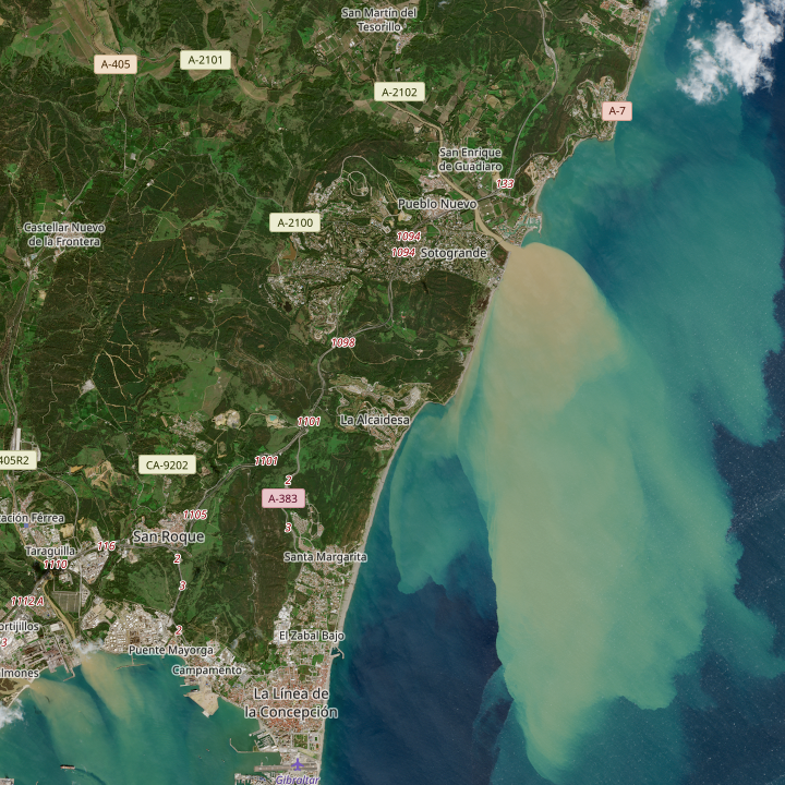
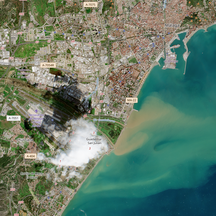
🛰️ Here's a bird's-eye view. You can clearly see the Rio Guadiaro in Sotogrande and the Rio Guadalhorce in #Malaga carrying sediment into the sea after the heavy rains. (c) SentinelHub - Hourly weather forecast meteo365.es
3
3
350

Très intéressante découverte de l'utilisation par @Playfra0 de la couche satellite "Ratio RVB" Sentinel-1 pour détecter tout type de fortifications.
J'ai testé sur Qgis à travers le plugin SentinelHub en y intégrant le script du projet Copernicus et cela fonctionne parfaitement !
3
3
23
4,643


7 Nov 2025
🛰️ Terrain & satellite tools help you scout in advance:
🔹 Google Earth
🔹 SentinelHub
🔹 Jeremy Perez’s chase map
They help you spot:
🌲 Tree cover
⛰️ Elevation issues
🛣️ Sketchy roads
5/9
1
2
30

13 Sep 2025
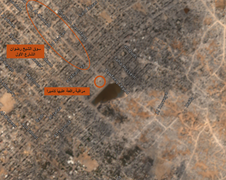
📡 صور حديثة من Sentinel Hub تكشف توسع التوغّل الإسرائيلي شمال #غزة حتى محيط بركة الشيخ رضوان، مع إقامة نقطة سيطرة على الشارع الأول. الخطوة تأتي ضمن عملية (#عربات_جدعون_2) تمهيداً لاحتلال مدينة غزة ودفع السكان للنزوح جنوباً.
#SentinelHub
#شمال_غزة #OSINT
1
3
58
13 Sep 2025
10
48
1,575

28 Jul 2025
🚀 Useful Python Libraries for GIS, Remote Sensing, and Mapping 🌍🛰️
Python continues to revolutionize geospatial analysis. Whether you're handling raster data, vector layers, or satellite imagery, these libraries can supercharge your workflows: 👉github.com/opengeos/python-g…
🔹 GeoPandas – Makes working with geospatial vector data (Shapefiles, GeoJSON, etc.) as easy as Pandas.
🔹 Rasterio – For reading, writing, and analyzing raster data (GeoTIFFs, satellite images).
🔹 Shapely – Geometry operations: buffers, intersections, unions, and more.
🔹 Fiona – Handles reading/writing vector data using GDAL under the hood.
🔹 Pyproj – Powerful coordinate transformation and projection handling.
🔹 xarray rioxarray – For working with large multi-dimensional raster datasets, especially satellite imagery.
🔹 scikit-image – Feature extraction, segmentation, and image transformations for RS tasks.
🔹 Folium – Creates interactive Leaflet maps right from Python notebooks.
🔹 Plotly / Kepler.gl / Pydeck – For stunning, interactive 2D/3D map visualizations.
🔹 WhiteboxTools – A command-line GIS tool with Python bindings for advanced terrain analysis, hydrology, and more.
🧠 Bonus:
Sentinelhub-py – Access Sentinel satellite imagery directly.
EarthPy – Simplifies RS workflows, especially for teaching and beginners.
🧵Let me know your favorite geospatial Python tools. Missed one? Drop it below 👇
#GIS #RemoteSensing #Python #Geospatial #Mapping #OpenSource #geoai

1
2
91

9 May 2025
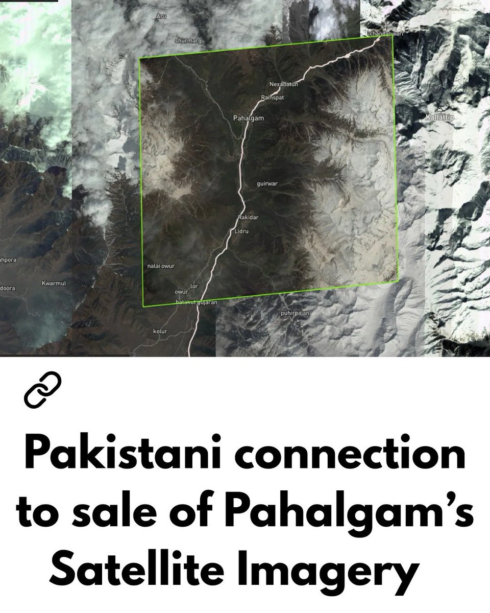
For the record, its wrong to blame maxar for selling it to anyone.
There are sites like SkyFi , EOS , Planet .com & sentinelhub etc..
anyone can pay a hundred $$$ and get images of any place on earth.
(also, American govt or CIA have nothing to do with it)
9 May 2025

Company Name - Maxar Technologies - sold pahalgam maps to a paki firm.


9
398

I share the link which you can use to do the same I did. Firstly, you need to be registered and log in to Sentinelhub. apps.sentinel-hub.com/eo-bro…
3
257
11 April 2025 view from Sentinelhub Browser. Do you see 🇻🇳Pair Trawlers are stealing and poaching our fish 50 NM from Ranai, Natuna (North of Anambas) ? At least there are 20 vessels. There are more such vessels in other scenes. #redcard4VietNam
1
5
16
2,471

22 Jan 2025
I’m hungry for SkyFi’s extra fries. Maybe someday we can easily order some stuffed crust Planetscope (optionally analysis ready baked), Planetary Variable toppings, and SentinelHub sauce.
1
1
86

21 Jan 2025
Sentinelシリーズのデータの検索・可視化ツールとして有名なEO Browserが遠くないうちに廃止され、Planet Insights Platformに統合されるようです。
Sentinelhubを運用しているSinergiseがPlanet Labsに吸収されて以降の一連の動きのひとつみたいですね。
forum.sentinel-hub.com/t/upd…
12
33
2,492

16 Jan 2025
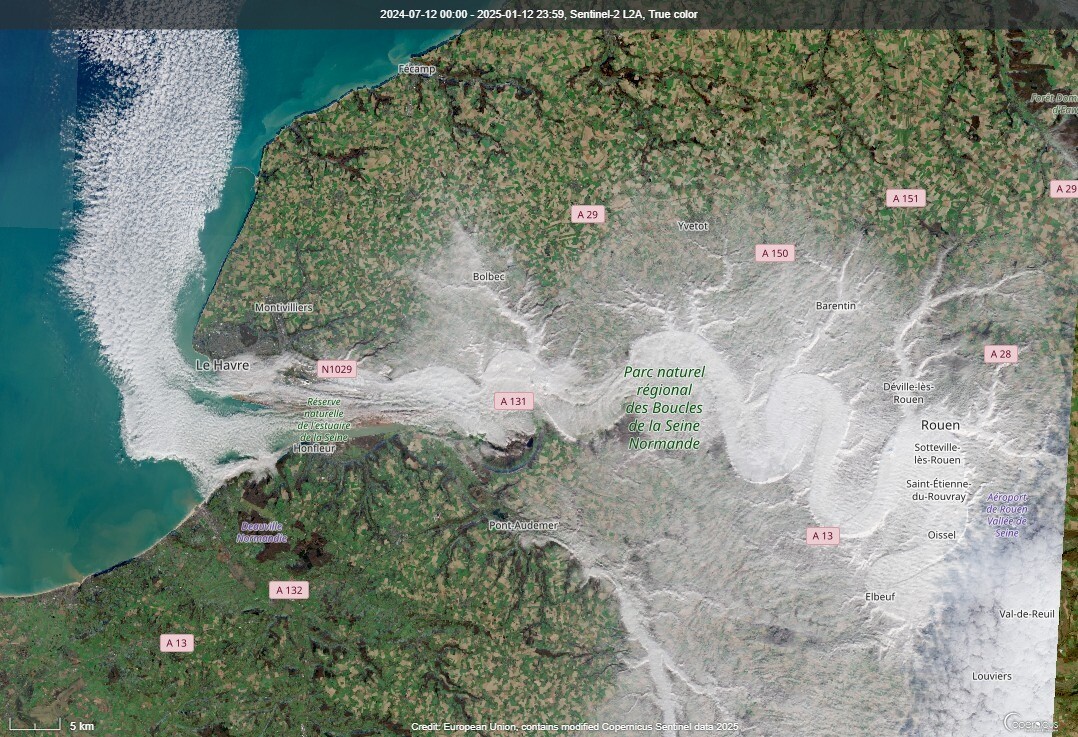
Schitterend voorbeeld dat koude lucht met mist de laagste plek opzoekt. Het dal van de #Seine vallei bij #Rouen in Frankrijk gevuld met ''koude mist''. Het stroomt uiteindelijk mooi Het Kanaal op. #sentinelhub
2
3
32
2,803


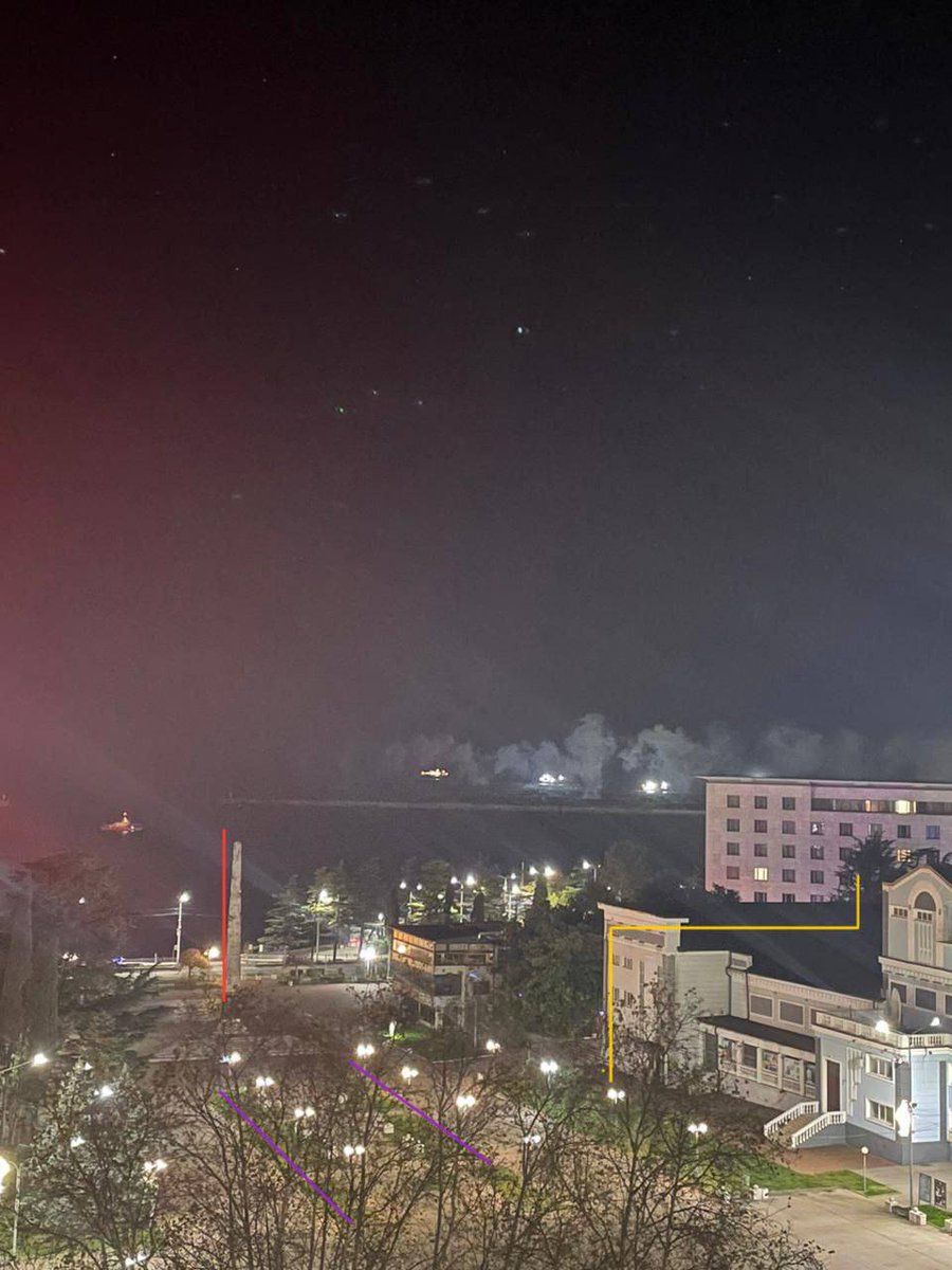
👀🔥 Nachts Rauch im Hafen von Tuapse!
❗️Laut Satellitenbildern von SentinelHub parkte am 20. November ein 135 Meter langes Schiff am Pier.
2
68

15 Oct 2024
You can use sentinelhub-py for access via Sentinel Hub, or check out Earth Search from Element84 or eoAPI from Development Seed.
But, the easiest might be the pystac-client.
pypi.org/project/pystac-clie…
1
10
807
21 Sep 2024
Maybe they will, but probably not anytime soon. For open-source SAR, check out data from the Sentinel-1 mission (on SentinelHub among other places) and the open data program from @umbraspace.
2
46