
IMD Warning RT:" Weather Update | 15 June 2026
✅ Southwest Monsoon advances into remaining parts of Andhra Pradesh, Telangana, Odisha, Jharkhand, Bihar & West Bengal.
⚠️ Heavy to Very Heavy Rainfall Alert:
📍 Sub-Himalayan West Bengal & Sikkim
📍 Arunachal Pradesh
📍 Assam & Meghalaya
⛈️ Rain, Thunderstorm & Gusty Winds:
J&K, Ladakh, Himachal Pradesh, Uttarakhand, Punjab, Haryana, Delhi, Rajasthan, Uttar Pradesh, Madhya Pradesh, Chhattisgarh, Bihar, Jharkhand, Odisha, Gujarat, Maharashtra, Goa, Karnataka, Kerala, Tamil Nadu, Andhra Pradesh, Telangana & Northeast India.
💨 Thundersquall/Duststorm:
📍 Rajasthan
📍 Haryana
📍 Delhi
📍 Punjab
📍 Uttar Pradesh
🔥 Heat Wave:
📍 Telangana
📍 Vidarbha
Please take necessary preparedness measures
@UP_SDMA @BsdmaBihar @BiharDMD @osdma @APSDMA @SEOC_Gujarat @SDMAMaharashtra @mpsdma @sdma_assam @MeghSdma @tnsdma @KeralaSDMA @GoaSdma @SEOC_Karnataka @KarnatakaSNDMC @StateHaryana @HPSDMA @USDMAUk @jk_sdma @UtLadakh @USDMAUk @ChandigarhAdmn @delhi_dm @DisasterMgmtTRP @Andaman_Admin @Lakshadweep @Puducherry @collr_karaikal @vidarbha @StateDisaster @sdma_assam @MeghSdma @HPSDMA @DIPRRajasthan @StateHaryana @GoaSdma @sikkimgovt

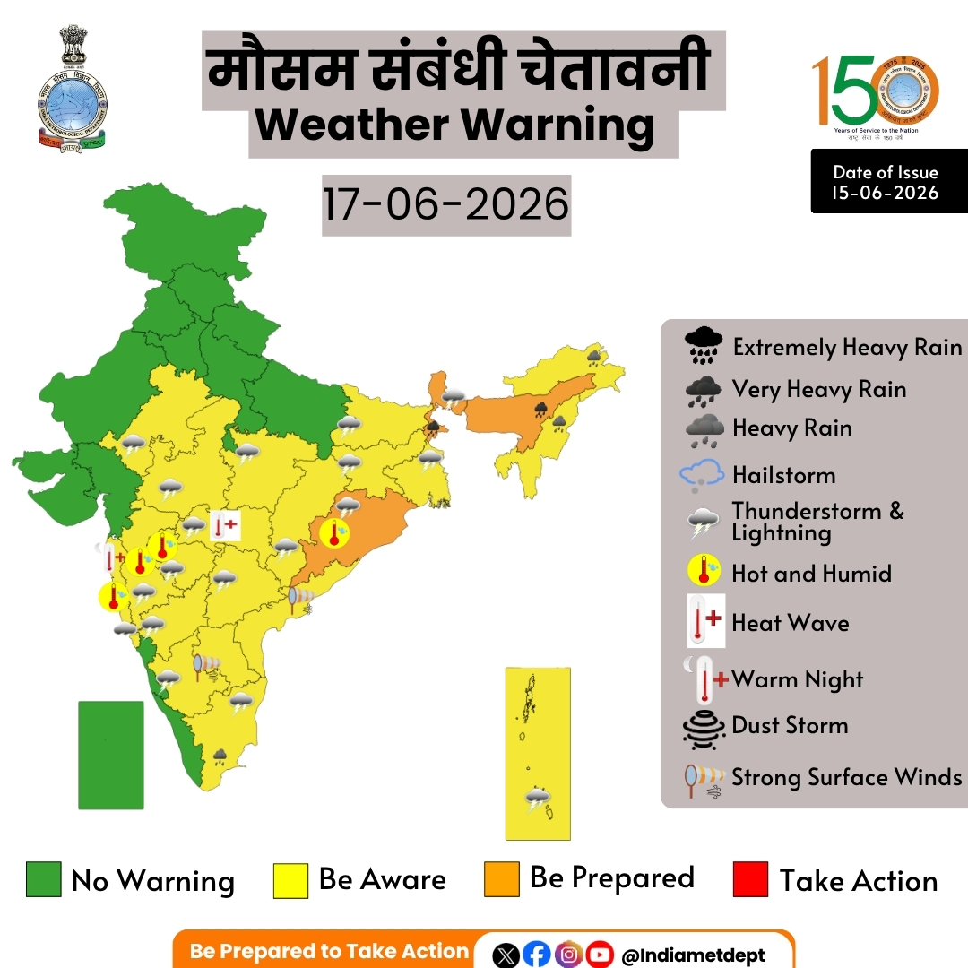
मौसम संबंधी चेतावनी
मुख्य बिंदु
(i) दक्षिण-पश्चिम मॉनसून आज, 15 जून 2026 को आंध्र प्रदेश, पश्चिम बंगाल के बाकी हिस्सों और तेलंगाना, ओडिशा, झारखंड व बिहार के कुछ और इलाकों में आगे बढ़ गया है।
(ii) अगले 6-7 दिनों के दौरान उप-हिमालयी पश्चिम बंगाल और सिक्किम, अरुणाचल प्रदेश तथा असम और मेघालय में कुछ जगहों पर भारी से बहुत भारी वर्षा होने की संभावना है।
(iii) अगले 2-3 दिनों के दौरान तेलंगाना और विदर्भ के कुछ इलाकों में उष्ण लहर चलने की बहुत संभावना है।
Highlights
(i) The Southwest Monsoon has further advanced into remaining parts of Andhra Pradesh, West Bengal, some more parts of Telangana, Odisha, Jharkhand & Bihar, today the 15th June, 2026.
(ii) Isolated heavy to very heavy rainfall likely over Sub-Himalayan West Bengal & Sikkim, Arunachal Pradesh and Assam & Meghalaya during next 6-7 days.
(iii) Heat wave conditions very likely in isolated pockets over Telangana and Vidarbha during next 2- 3 days.
Northwest India:
❖ Isolated to Scattered rainfall likely over Jammu-Kashmir-Ladakh-Gilgit-Baltistan-Muzaffarabad during 15th-17th June; Himachal Pradesh and Uttarakhand during 15th-21st June.
❖ Isolated to Scattered rainfall likely over East Rajasthan, Haryana Chandigarh & Delhi, Punjab and West Rajasthan during 15th-21st June; West Uttar Pradesh during 15th-19th June; East Uttar Pradesh during 17th-18th June.
❖ Fairly Widespread to Widespread rainfall likely over Jammu-Kashmir-Ladakh-Gilgit-Baltistan-Muzaffarabad during 18th-21st June.
❖ Isolated thunderstorm, lightning & gusty winds (speed reaching 40-50 kmph gusting to 60 kmph) likely over Jammu-Kashmir-Ladakh-Gilgit-Baltistan-Muzaffarabad during 15th-16th June and during 18th-21st June; Himachal Pradesh during 18th-19th June; Uttarakhand on 15th June and on 19th June.
❖ Isolated thunderstorm, lightning & gusty winds (speed reaching 40-50 kmph gusting to 60 kmph) likely over Haryana Chandigarh & Delhi and Punjab on 16th June and during 18th-20th June; East Rajasthan during 19th-21st June.
❖ Thundersquall (wind speed reaching 60-70 kmph gusting to 80 kmph) likely over East Rajasthan, Haryana Chandigarh & Delhi and Punjab on 15th June; West Rajasthan during 15th-16th June.
❖ Thundersquall (wind speed reaching 50-60 kmph gusting to 70 kmph) likely over West Uttar Pradesh on 15th June; East Rajasthan during 17th-18th June.
❖ Isolated Hailstorm activity likely over Jammu-Kashmir-Ladakh-Gilgit-Baltistan-Muzaffarabad during 18th-19th June.
❖ Duststorm activity likely over West Rajasthan during 15th-16th June; East Rajasthan on 15th June.
Central India:
❖ Isolated to Scattered rainfall likely over Chhattisgarh, East Madhya Pradesh, Vidarbha and West Madhya Pradesh during 15th-21st June.
❖ Isolated thunderstorm, lightning & gusty winds (speed reaching 40-50 kmph gusting to 60 kmph) likely over East Madhya Pradesh and West Madhya Pradesh during 16th-19th June; Chhattisgarh and Vidarbha during 15th19th June.
❖ Thundersquall (wind speed reaching 50-60 kmph gusting to 70 kmph) likely over East Madhya Pradesh and West Madhya Pradesh on 15th June.
East India:
❖ Fairly Widespread to Widespread rainfall likely over Andaman & Nicobar Islands and Sub-Himalayan West Bengal & Sikkim during 15th-21st June; Gangetic West Bengal during 20th-21st June; Odisha during 15th-16th June.
❖ Isolated to Scattered rainfall likely over Gangetic West Bengal during 15th-19th June; Bihar and Jharkhand during 15th-21st June; Odisha during 17th-21st June.
❖ Isolated thunderstorm, lightning & gusty winds (speed reaching 40-50 kmph gusting to 60 kmph) likely over Andaman & Nicobar Islands, Gangetic West Bengal and Sub-Himalayan West Bengal & Sikkim during 15th-21st June; Bihar and Jharkhand during 15th-19th June; Odisha on 16th June and on 19th June.
❖ Isolated heavy rainfall likely over Sub-Himalayan West Bengal & Sikkim during 15th-16th June and on 21st June; Bihar on 16th June and on 19th June; Odisha on 15th June with isolated very heavy rainfall also likely over SubHimalayan West Bengal & Sikkim during 17th-20th June.
❖ Thundersquall (wind speed reaching 50-60 kmph gusting to 70 kmph) likely over Bihar during 20th-21st June; Odisha on 15th June and during 17th-18th June
Northeast India:
❖ Fairly Widespread to Widespread rainfall likely over Arunachal Pradesh, Assam & Meghalaya and Nagaland, Manipur, Mizoram & Tripura during 15th-21st June.
❖ Isolated thunderstorm & lightning likely over Arunachal Pradesh, Assam & Meghalaya and Nagaland, Manipur, Mizoram & Tripura during 15th-19th June.
❖ Isolated heavy rainfall likely over Arunachal Pradesh during 15th-17th June; Assam & Meghalaya during 15th16th June; Nagaland, Manipur, Mizoram & Tripura during 17th-20th June with isolated very heavy rainfall also likely over Arunachal Pradesh during 18th-21st June; Assam & Meghalaya during 17th-21st June.
West India:
❖ Isolated to Scattered rainfall likely over Gujarat Region, Konkan & Goa, Madhya Maharashtra and Marathawada during 15th-21st June; Saurashtra & Kutch during 18th-21st June.
❖ Isolated thunderstorm, lightning & gusty winds (speed reaching 40-50 kmph gusting to 60 kmph) likely over Konkan & Goa during 15th-17th June; Madhya Maharashtra and Marathawada during 15th-18th June. South Peninsular India:
❖ Isolated to Scattered rainfall likely over Coastal Andhra Pradesh & Yanam, North Interior Karnataka, Rayalaseema and Tamil Nadu, Puducherry & Karaikal during 15th-21st June; Lakshadweep during 15th-17th June; Coastal Karnataka during 15th-16th June; South Interior Karnataka during 15th-18th June; Telangana during 15th-20th June.
❖ Fairly Widespread to Widespread rainfall likely over Kerala & Mahe during 15th-21st June; Lakshadweep during 18th-21st June; Coastal Karnataka during 17th-21st June; South Interior Karnataka during 19th-21st June; Telangana on 21st June.
❖ Isolated thunderstorm, lightning & gusty winds (speed reaching 40-50 kmph gusting to 60 kmph) likely over North Interior Karnataka, South Interior Karnataka, Tamil Nadu, Puducherry & Karaikal and Telangana during 15th19th June, with gusty winds (speed reaching 30-40 kmph gusting to 50 kmph) likely over Coastal Karnataka during 15th-19th June.
❖ Isolated heavy rainfall likely over Tamil Nadu, Puducherry & Karaikal during 16th-18th June; Kerala & Mahe on 16th June.
❖ Strong Surface Winds likely over Coastal Andhra Pradesh & Yanam and Rayalaseema during 15th-19th June.
Forecast of maximum/day temperatures:
❖ Gradual rise in maximum temperatures likely over Northwest India by 2-4°C till 18th and thereafter no significant change during 19th – 21st June.
❖ No significant change in maximum temperatures likely over the rest parts of country till 21st June 2026.
Heat Wave, Hot & Humid weather conditions warning:
❖ Heat wave conditions very likely in isolated pockets over Telangana during 15th-16th June; Vidarbha during 15th-17th June.
❖ Hot and humid weather conditions likely to prevail over Konkan & Goa, Madhya Maharashtra, Marathawada and Odisha during 15th-17th June.
❖ Warm Night conditions very likely to prevail in isolated pockets over Konkan & Goa during 15th-18th June.
For more information, visit Us : mausam.imd.gov.in
#SouthwestMonsoon #WeatherUpdate #HeavyRainfall #HeatWave #Thunderstorm #IndiaWeather #RainForecast #Monsoon2026 #WeatherWarnings
@moesgoi @airnewsalerts @DDNational @ndmaindia @ICRER_MHA


196
CMO Nagaland retweeted

Jun 9
With the onset of the monsoon season, staying informed is essential. The Safer Nagaland App by @StateDisaster is a citizen-centric app, which provides timely alerts, information & safety resources, advancing our commitment to a safer, better-informed Nagaland. #KnowYourGovernment


14
41
983
IMD Warning RT:"Heavy to very heavy rainfall (7–20 cm) is very likely over Kerala, Karnataka, Tamil Nadu, and Northeast India during the next 7 days.
⚠️ Isolated extremely heavy rainfall is also likely over Karnataka during 8–10 June." @KeralaSDMA @kerala @SEOC_Karnataka @KarnatakaSNDMC @tnsdma @DMRMizoram @southtripuraDM @DisasterMgmtTRP @sdma_assam @StateDisaster @MeghSdma @sikkimgovt @aruna
🌧️ IMD Weather Warning !
Heavy to very heavy rainfall (7–20 cm) is very likely over Kerala, Karnataka, Tamil Nadu, and Northeast India during the next 7 days.
⚠️ Isolated extremely heavy rainfall is also likely over Karnataka during 8–10 June.
Stay updated with official weather forecasts and take necessary precautions in vulnerable areas.
#IMD #WeatherUpdate #HeavyRainfall #Monsoon2026 #KarnatakaRain #KeralaWeather #NortheastIndia
@moesgoi @airnewsalerts @DDNational @ndmaindia @ICRER_MHA
1
2
133
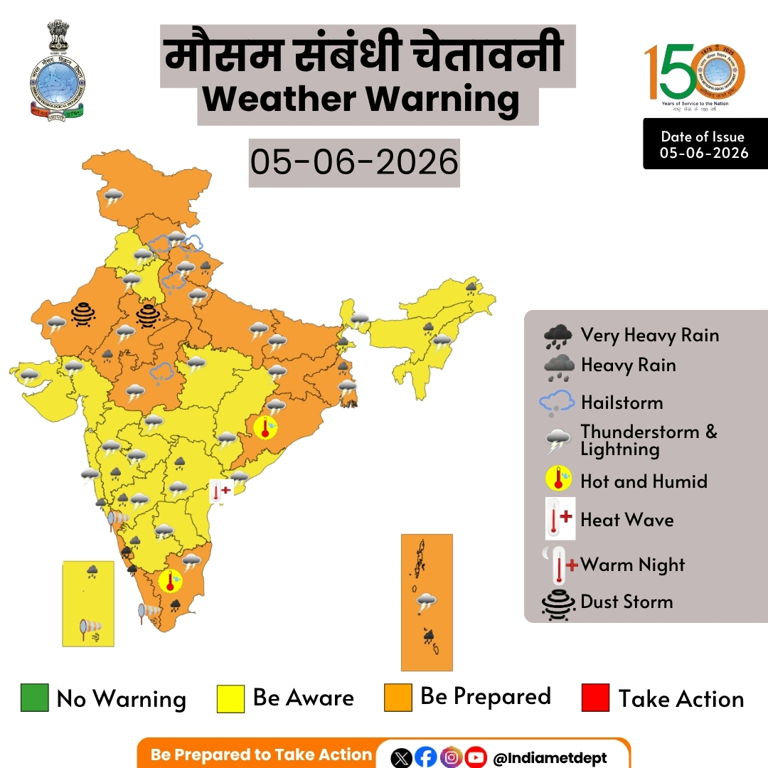
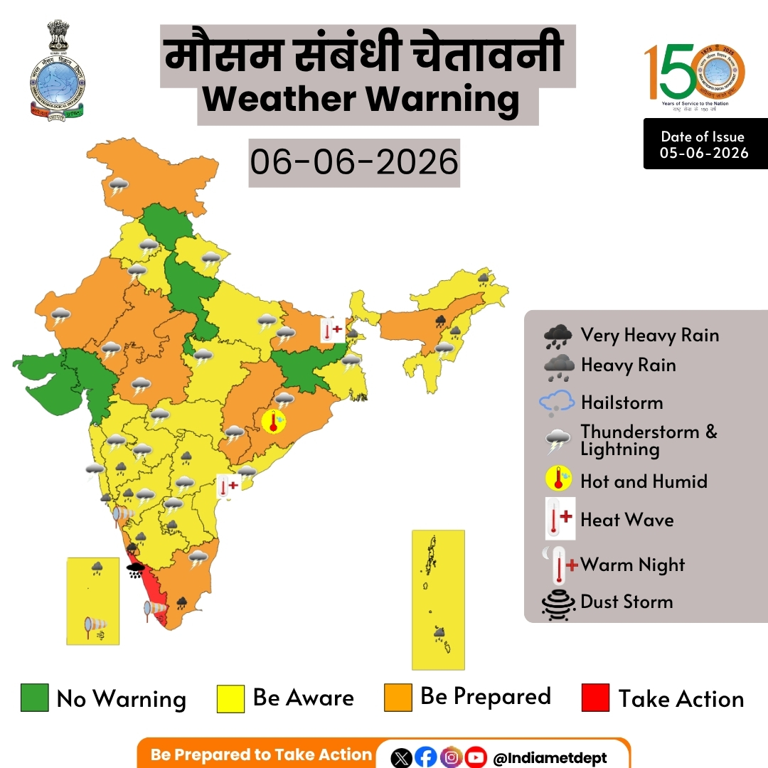
IMD Warning RT: "(i) Southwest monsoon has further advance into some more parts of Karnataka, Tamilnadu and some parts of Goa on today, the 5th June 2026. ii) Isolated heavy to very heavy rainfall (7-20cm) very likely over Kerala & Karnataka and isolated heavy rainfall over Tamil Nadu and during next 7 days. Isolated extremely heavy rainfall is also likely over Kerala on 06th & 07th June. Isolated heavy to very heavy rainfall is also likely to continue over northeast India during next 7 days." @UP_SDMA @DDMA_official @SEOC_Gujarat @SDMAMaharashtra @sdma_assam @MeghSdma @ChandigarhAdmn @SEOC_Gujarat @delhi_dm @jk_sdma @StateHaryana @HPSDMA @SEOC_Karnataka @KarnatakaSNDMC @DisasterMgmtTRP @USDMAUk @ddmani4 @UtLadakh @BsdmaBihar @PdmapunjabO @mpsdma @BiharDMD @tnsdma @KeralaSDMA @BiharDMD @osdma @osdmaodisha @APSDMA @tnsdma @StateDisaster @GoaSdma @Andaman_Admin @Lakshadweep
मौसम संबंधी चेतावनी
मुख्य बिंदु
(i) दक्षिण-पश्चिम मानसून आज, 5 जून 2026 को कर्नाटक, तमिलनाडु तथा गोवा के कुछ और भागों में आगे बढ़ गया है।
(ii) अगले 7 दिनों के दौरान केरल एवं कर्नाटक में अलग-अलग स्थानों पर भारी से बहुत भारी वर्षा (7-20 सेमी) तथा तमिलनाडु में अलग-अलग स्थानों पर भारी वर्षा होने की बहुत संभावना है। केरल में 6 एवं 7 जून को अलग-अलग स्थानों पर अत्यंत भारी वर्षा होने की भी संभावना है। इसके अलावा, पूर्वोत्तर भारत में भी अगले 7 दिनों के दौरान अलग-अलग स्थानों पर भारी से बहुत भारी वर्षा का दौर जारी रहने की संभावना है।
Highlights
(i) Southwest monsoon has further advance into some more parts of Karnataka, Tamilnadu and some
parts of Goa on today, the 5th June 2026.
ii) Isolated heavy to very heavy rainfall (7-20cm) very likely over Kerala & Karnataka and isolated heavy rainfall
over Tamil Nadu and during next 7 days. Isolated extremely heavy rainfall is also likely over Kerala on 06th &
07th June. Isolated heavy to very heavy rainfall is also likely to continue over northeast India during next 7 days.
Northeast India:
❖ Fairly Widespread to Widespread rainfall likely over Arunachal Pradesh and Assam & Meghalaya during 5th11th June; Nagaland, Manipur, Mizoram & Tripura during 6th-11th June and Isolated to Scattered rainfall likely over Nagaland, Manipur, Mizoram & Tripura on 5th June.
❖ Isolated thunderstorm, lightning & gusty winds (speed reaching 40-50 kmph gusting to 60 kmph) likely over Assam & Meghalaya during 5th-7th June; Nagaland, Manipur, Mizoram & Tripura during 5th-8th June, with gusty winds (speed reaching 30-40 kmph gusting to 50 kmph) likely over Assam & Meghalaya on 8th June and Isolated thunderstorm & lightning likely over Arunachal Pradesh during 5th-9th June; Assam & Meghalaya and Nagaland, Manipur, Mizoram & Tripura on 9th June.
❖ Isolated heavy rainfall likely over Arunachal Pradesh during 5th-6th June; Assam & Meghalaya on 5th June; Nagaland, Manipur, Mizoram & Tripura during 6th-11th June with isolated very heavy rainfall also likely over Arunachal Pradesh during 7th-11th June; Assam & Meghalaya during 6th-11th June.
South Peninsular India:
❖ Isolated to Scattered rainfall likely over Coastal Andhra Pradesh & Yanam, Rayalaseema and Tamil Nadu, Puducherry & Karaikal during 5th-11th June; North Interior Karnataka during 6th-11th June; South Interior Karnataka on 5th June and during 8th-11th June and Fairly Widespread to Widespread rainfall likely over Coastal Karnataka, Kerala & Mahe, Lakshadweep and Telangana during 5th-11th June; North Interior Karnataka on 5th June; South Interior Karnataka during 6th-7th June.
❖ Isolated thunderstorm, lightning & gusty winds (speed reaching 40-50 kmph gusting to 60 kmph) likely over Tamil Nadu, Puducherry & Karaikal during 5th-7th June; Coastal Andhra Pradesh & Yanam, North Interior Karnataka and Rayalaseema during 5th-9th June; Telangana during 5th-6th June, with gusty winds (speed reaching 30-40 kmph gusting to 50 kmph) likely over South Interior Karnataka during 5th-7th June and Isolated thunderstorm & lightning likely over Tamil Nadu, Puducherry & Karaikal during 8th-9th June; Kerala & Mahe and Lakshadweep during 5th-6th June; Coastal Karnataka during 5th-9th June.
❖ Isolated heavy rainfall likely over Tamil Nadu, Puducherry & Karaikal during 8th-11th June; Kerala & Mahe during 6th-7th June and during 10th-11th June; Lakshadweep during 5th-7th June; North Interior Karnataka and South Interior Karnataka during 5th-11th June; Coastal Andhra Pradesh & Yanam during 7th-8th June and during 10th11th June; Rayalaseema during 6th-7th June; Telangana during 5th-6th June with isolated very heavy rainfall also likely over Tamil Nadu, Puducherry & Karaikal during 5th-7th June; Kerala & Mahe on 5th June and during 8th-9th June; Coastal Karnataka during 5th-11th June.
East India:
❖ Fairly Widespread to Widespread rainfall likely over Andaman & Nicobar Islands and Sub-Himalayan West Bengal & Sikkim during 5th-11th June; Gangetic West Bengal on 5th June and Isolated to Scattered rainfall likely over Gangetic West Bengal during 6th-11th June; Jharkhand during 5th-8th June and during 10th-11th June; Bihar and Odisha during 5th-11th June.
❖ Isolated thunderstorm, lightning & gusty winds (speed reaching 40-50 kmph gusting to 60 kmph) likely over Andaman & Nicobar Islands during 10th-11th June; Sub-Himalayan West Bengal & Sikkim during 5th-11th June; Gangetic West Bengal during 6th-11th June; Jharkhand during 6th-8th June; Bihar during 7th-8th June; Odisha during 7th-9th June.
❖ Isolated heavy rainfall likely over Andaman & Nicobar Islands on 6th June and during 8th-10th June; SubHimalayan West Bengal & Sikkim during 5th-7th June and during 9th-11th June; Gangetic West Bengal on 5th June with isolated very heavy rainfall also likely over Andaman & Nicobar Islands on 5th June; Sub-Himalayan West Bengal & Sikkim on 8th June.
❖ Thundersquall (wind speed reaching 50-60 kmph gusting to 70 kmph) likely over Andaman & Nicobar Islands during 5th-9th June; Gangetic West Bengal and Jharkhand on 5th June; Bihar during 5th-6th June and during 9th-10th June; Odisha during 5th-6th June.
Northwest India:
❖ Fairly Widespread to Widespread rainfall likely over Jammu-Kashmir-Ladakh-Gilgit-Baltistan-Muzaffarabad during 5th-6th June; Himachal Pradesh and Uttarakhand on 5th June.
❖ Isolated to Scattered rainfall likely over Haryana Chandigarh & Delhi and Punjab during 5th-7th June and on 11th June; West Uttar Pradesh during 5th-6th June and on 11th June; East Uttar Pradesh during 5th-6th June and during 10th-11th June; West Rajasthan during 5th-7th June; East Rajasthan during 5th-11th June; Jammu-KashmirLadakh-Gilgit-Baltistan-Muzaffarabad during 7th-11th June; Himachal Pradesh and Uttarakhand during 6th-11th June.
❖ Isolated thunderstorm, lightning & gusty winds (speed reaching 40-50 kmph gusting to 60 kmph) likely over Jammu-Kashmir-Ladakh-Gilgit-Baltistan-Muzaffarabad during 5th-6th June; Himachal Pradesh on 5th June; Uttarakhand on 6th June, with gusty winds (speed reaching 30-40 kmph gusting to 50 kmph) likely over Himachal Pradesh on 6th June.
❖ Isolated thunderstorm, lightning & gusty winds (speed reaching 40-50 kmph gusting to 60 kmph) likely over Haryana Chandigarh & Delhi and Punjab during 5th-6th June and on 11th June; East Uttar Pradesh on 6th June, with gusty winds (speed reaching 30-40 kmph gusting to 50 kmph) likely over West Rajasthan on 7th June; East Rajasthan during 7th-11th June.
❖ Isolated heavy rainfall likely over East Rajasthan and Uttarakhand on 5th June.
❖ Thundersquall (wind speed reaching 50-60 kmph gusting to 70 kmph) likely over East Uttar Pradesh, Uttarakhand and West Uttar Pradesh on 5th June; East Rajasthan and West Rajasthan during 5th-6th June.
❖ Isolated Hailstorm activity likely over Himachal Pradesh, Uttarakhand and West Uttar Pradesh on 5th June.
❖ Duststorm activity likely over East Rajasthan and West Rajasthan on 5th June.
Central India:
❖ Isolated to Scattered rainfall likely over Chhattisgarh, East Madhya Pradesh, Vidarbha and West Madhya Pradesh during 5th-11th June.
❖ Isolated thunderstorm, lightning & gusty winds (speed reaching 40-50 kmph gusting to 60 kmph) likely over West Madhya Pradesh during 7th-9th June; East Madhya Pradesh during 5th-9th June; Vidarbha during 5th6th June; Chhattisgarh on 5th June and during 8th-9th June, with gusty winds (speed reaching 30-40 kmph gusting to 50 kmph) likely over Vidarbha during 7th-9th June.
❖ Thundersquall (wind speed reaching 50-60 kmph gusting to 70 kmph) likely over West Madhya Pradesh during 5th-6th June; Chhattisgarh during 6th-7th June.
❖ Isolated Hailstorm activity likely over West Madhya Pradesh on 5th June.
West India:
❖ Isolated to Scattered rainfall likely over Gujarat Region, Konkan & Goa, Madhya Maharashtra, Marathawada and Saurashtra & Kutch during 5th-11th June.
❖ Isolated thunderstorm, lightning & gusty winds (speed reaching 40-50 kmph gusting to 60 kmph) likely over Konkan & Goa during 5th-10th June; Madhya Maharashtra and Marathawada during 5th-9th June; Gujarat Region and Saurashtra & Kutch on 5th June.
❖ Isolated heavy rainfall likely over Konkan & Goa and Madhya Maharashtra during 5th-9th Jun.
Forecast of maximum/day temperatures:
❖ Gradual fall in maximum temperatures likely over Northwest India by 2-4°C till 5th June and thereafter gradual rise by 3-5°C during 6th -11th June.
❖ No significant change in maximum temperatures likely over Central India till 07th June and thereafter gradual rise by 2-3°C during 08th -11th June.
❖ Gradual fall in maximum temperatures likely over Maharashtra by 2-3°C till 07th June and thereafter no significant change till 11th June 2026.
❖ No significant change in maximum temperatures likely over the rest parts of country till 11th June 2026.
Heat Wave, Hot & Humid weather conditions warning:
❖ Heat wave conditions very likely in isolated pockets over Coastal Andhra Pradesh & Yanam during 5th-6th June; East Uttar Pradesh during 9th-11th June; West Rajasthan during 8th-11th June; West Uttar Pradesh during 9th to 11th June.
❖ Hot and humid weather conditions likely to prevail over Odisha during 5th-9th June; Tamil Nadu, Puducherry & Karaikal on 5th June; Coastal Andhra Pradesh & Yanam on 7th June.
For more information, visit Us : mausam.imd.gov.in
#Monsoon2026 #HeavyRainfall #WeatherUpdate #IndiaWeather #RainForecast #ThunderstormAlert #NortheastIndia #SouthwestMonsoon #WeatherWarnings
@moesgoi @airnewsalerts @DDNational @ndmaindia @ICRER_MHA

2
90

May 28
Indian Red Cross Society Nagaland state branch and NSDMA organizing training for Community First Responder at Mokokchung.
facebook.com/allindiaradione…
@IndianRedCross | @StateDisaster
@airnewsalerts
@airkohima2
@dipr_nagaland
@MyGovNagaland

1
2
12
IMD Warning RT:"(i) Heat wave to severe heat wave conditions likely to continue over Central & Northwest India during next 2-3 days. (ii) Reduction in maximum temperatures and abatement of heat wave conditions are likely from 29th May onwards. (iii) Isolated heavy to very rainfall likely over Northeast and adjoining East India during next 2-3 days and over south peninsular India today, the 27th May, and over Tamil Nadu, Puducherry & Karaikal during 27th – 29th May 2026. (iv) Moderate to Severe Thunderstorm activity with squally wind speed reaching upto 70 kmph over Northwest India, Central India and East India during 28th – 30th May." @UP_SDMA @DDMA_official @SEOC_Gujarat @SDMAMaharashtra @sdma_assam @MeghSdma @ChandigarhAdmn @SEOC_Gujarat @delhi_dm @jk_sdma @StateHaryana @HPSDMA @SEOC_Karnataka @KarnatakaSNDMC @DisasterMgmtTRP @USDMAUk @UtLadakh
@BsdmaBihar @PdmapunjabO @mpsdma
@BiharDMD @tnsdma @KeralaSDMA @osdma @osdmaodisha @APSDMA @tnsdma
@StateDisaster @GoaSdma @Andaman_Admin
@Lakshadweep @Puducherry @collr_karaikal
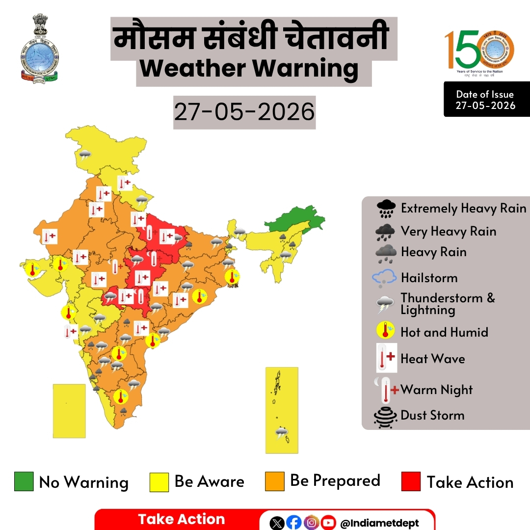
मौसम संबंधी चेतावनी
मुख्य बिंदु
(i) मध्य और उत्तर-पश्चिम भारत में अगले 2-3 दिनों के दौरान उष्ण लहर से लेकर भीषण उष्ण लहर की स्थिति जारी रहने की संभावना है।
(ii) 29 मई से अधिकतम तापमान में कमी आने और उष्ण लहर की स्थिति में राहत मिलने की संभावना है।
(iii) उत्तर-पूर्व और उससे सटे पूर्वी भारत में अगले 2-3 दिनों के दौरान, दक्षिण प्रायद्वीपीय भारत में आज यानी 27 मई को और तमिलनाडु, पुडुचेरी और कराईकल में 27 मई से 29 मई 2026 के दौरान अलग-अलग स्थानों पर भारी से बहुत भारी वर्षा होने की संभावना है।
(iv) उत्तर-पश्चिम भारत, मध्य भारत और पूर्वी भारत में 28 मई से 30 मई के दौरान 70 किमी प्रति घंटे तक की तेज़ हवाओं के साथ मध्यम से गंभीर गरज-चमक वाली आंधी आने की संभावना है।
Highlights
(i) Heat wave to severe heat wave conditions likely to continue over Central & Northwest India during next 2-3 days.
(ii) Reduction in maximum temperatures and abatement of heat wave conditions are likely from 29th May onwards.
(iii) Isolated heavy to very rainfall likely over Northeast and adjoining East India during next 2-3 days and over south peninsular India today, the 27th May, and over Tamil Nadu, Puducherry & Karaikal during 27th – 29th May 2026.
(iv) Moderate to Severe Thunderstorm activity with squally wind speed reaching upto 70 kmph over Northwest India, Central India and East India during 28th – 30th May.
Northeast India:
❖ Scattered to Fairly widespread light to moderate rainfall with thunderstorm, lightning & gusty winds (speed reaching 40-50 kmph) likely over Nagaland, Manipur, Mizoram & Tripura on 27th & 28th May.
❖ Isolated heavy rainfall likely over Arunachal Pradesh on 01st & 2nd June; Assam & Meghalaya during 27th & 28th May & on 02nd June; Nagaland, Manipur, Mizoram & Tripura on 27th, 28th May and during 30th May & 02nd June.
South Peninsular India:
❖ Isolated to scattered light to moderate rainfall with thunderstorm, lightning & gusty winds (speed reaching 40-50 kmph) likely over Tamil Nadu, Puducherry & Karaikal, Interior Karnataka during 27th May -2nd June, Coastal Andhra Pradesh & Yanam, Rayalaseema, Telangana, Interior Karnataka during 27th May -31st May.
❖ Thundersquall (wind speed reaching 50-60 kmph gusting to 70 kmph) likely over Tamil Nadu, Puducherry & Karaikal on 27th; North Interior Karnataka, Coastal Andhra Pradesh & Yanam, Rayalaseema during 27th-29th; South Interior Karnataka on 27th & 28th; May.
❖ Isolated Heavy rainfall also likely over Tamil Nadu, Puducherry & Karaikal during 27th-29th, Kerala & Mahe on 27th May and on 1st & 2nd June; Lakshadweep on 1st & 2nd June; Coastal Karnataka, Interior Karnataka, Rayalaseema, Telangana on 27th May.
East India:
❖ Fairly widespread to widespread light to moderate rainfall with thunderstorm, lightning & gusty winds (speed reaching 40-50 kmph)likely over Andaman & Nicobar Islands during 27th May-02nd June; Sub-Himalayan West Bengal & Sikkim during 27th – 29th; Gangetic West Bengal during 27th – 31st.
❖ Isolated to scattered light to moderate rainfall with thunderstorm, lightning & gusty winds (speed reaching 40-50 kmph) likely over Bihar, Odisha during 27th-31st May; Jharkhand during 27th May-01st June.
❖ Thundersquall (wind speed reaching 60-70 kmph gusting to 80 kmph) likely over Gangetic West Bengal on 28th; Bihar on 28th & 29th May.
❖ Thundersquall (wind speed reaching 50-60 kmph gusting to 70 kmph) likely over Gangetic West Bengal during 27th 29th May; Bihar on 27th; Jharkhand, Odisha during 27th-30th May.
❖ Isolated heavy rainfall likely over Andaman & Nicobar Islands during 29th-31st May; Sub-Himalayan West Bengal & Sikkim on 27th May; Gangetic West Bengal on 28th; Bihar during 27th -29th; Odisha on 29th & 30th May.
Northwest India:
❖ Scattered to fairly widespread light to moderate rainfall with thunderstorm, lightning & gusty winds (speed reaching 40-50 kmph) likely over Jammu-Kashmir and Uttarakhand during 27th-30th May; Himachal Pradesh on 28th & 29th; Uttarakhand during 27th – 30th May.
❖ Scattered to fairly widespread light to moderate rainfall with thunderstorm, lightning & gusty winds (speed reaching 40-50 kmph) likely over West Uttar Pradesh during 28th-31st and East Uttar Pradesh during 27th-31st; May.
❖ Thundersquall (wind speed reaching 80-90 kmph gusting to 100 kmph) likely over Punjab, Haryana Chandigarh & Delhi, West Uttar Pradesh on 29th May
❖ Thundersquall (wind speed reaching 60-70 kmph gusting to 80 kmph) likely over Punjab, Haryana Chandigarh & Delhi, West Uttar Pradesh on 28th; East Uttar Pradesh on 29th May.
❖ Thundersquall (wind speed reaching 50-60 kmph gusting to 70 kmph) likely over Rajasthan, JammuKashmir, Uttarakhand on 28th & 29th; Punjab, Haryana Chandigarh & Delhi on 30th; East Uttar Pradesh during 28th30th May.
❖ Isolated heavy rainfall likely over Uttarakhand, West Uttar Pradesh on 29th; Punjab, Haryana, Chandigarh on 29th & 30th May.
❖ Isolated Hailstorm activity likely over Himachal Pradesh, Uttarakhand, Punjab, Haryana Chandigarh & Delhi, West Uttar Pradesh on 28th & 29th May and East Uttar Pradesh, Rajasthan on 29th May.
❖ Duststorm very likely at isolated places over Uttar Pradesh and Rajasthan on 28th & 29th May.
Central India:
❖ Isolated light to moderate rainfall with thunderstorm, lightning & gusty winds (speed reaching 40-50 kmph) likely over West Madhya Pradesh 28th May – 01st June; East Madhya Pradesh, Vidarbha 27th – 31st May; Chhattisgarh 27th May – 02nd June;
❖ Thundersquall (wind speed reaching 50-60 kmph gusting to 70 kmph) likely over West Madhya Pradesh on 29th & 30th May; East Madhya Pradesh, Chhattisgarh during 29th - 31st May
❖ Isolated Hailstorm activity likely over Madhya Pradesh on 29th & 30th May. Chhattisgarh on 29th May.
West India:
❖ Isolated light to moderate rainfall with thunderstorm, lightning & gusty winds (speed reaching 40-50 kmph) likely over Madhya Maharashtra, Marathawada on 27th , 28th May and on 01st & 2nd June; Gujarat state during 30th May – 02nd June; Konkan & Goa on 27th May ,01st & 02nd June.
Forecast of maximum/day temperatures:
❖ No significant change in maximum temperatures likely over Northwest India till 27th May; gradual fall by 6-8°C during 28th - 30th May and gradual rise by 4-6°C during 31st May-02nd June.
❖ No significant change in maximum temperatures likely over Central India till 27th May and gradual fall by 3-5°C during 28th May-02nd June.
❖ No significant change in maximum temperatures likely over East India till 27th May and gradual fall by 2-4°C during 28th May-02nd June.
❖ No significant change in maximum temperatures likely over Maharashtra till 28th and gradual fall by 2-4°C during 29th May-02nd June.
❖ No significant change in maximum temperatures likely over Gujrat State till 30th May and gradual fall by 2-4°C during 31st May-02nd June.
❖ No significant change in maximum temperatures likely over south peninsular India till 29th May and gradual fall by 2-3°C during 30st May-02nd June.
❖ No significant change in maximum temperatures likely over the rest parts of country till 02nd June 2026.
Heat Wave, Hot & Humid weather and Warm Night conditions warning:
❖ Heat wave conditions very likely in isolated/some pockets over Punjab, Haryana, Chandigarh & Delhi, Uttar Pradesh on 27th & 28th; with severe heat wave conditions in some pockets over East Uttar Pradesh Punjab, Haryana, Chandigarh & Delhi on 27th May.
❖ Heat wave conditions very likely in isolated/some pockets over West Rajasthan during 27th-29th; East Rajasthan on 27th & 28th May; with severe heat wave conditions in some pockets over West Rajasthan on 27th & 28th; East Rajasthan on 27th May.
❖ Heat wave conditions very likely in isolated pockets over Madhya Pradesh during 27th – 29th; Chhattisgarh on 27th& 28th with severe heat wave conditions in isolated pockets over West Madhya Pradesh on 27th; East Madhya Pradesh, Vidarbha, on 27th & 28th May.
❖ Heat wave conditions very likely in isolated pockets Telangana during 27th – 29th; Himachal Pradesh, Odisha on 27th & 28th May
❖ Hot and humid weather conditions likely to prevail over Gangetic West Bengal on 27th; Odisha during 27th – 31st; Konkan & Goa, Coastal Areas Gujarat State on 27th & 28th; Tamil Nadu, Puducherry & Karaikal, Coastal Andhra Pradesh & Yanam during 27th – 29th May.
❖ Warm Night conditions very likely to prevail in isolated pockets over Odisha on 27th & 28th; Madhya Pradesh, Vidarbha on 27th May.
#SevereWeather #HeatWave #RainfallForecast #Thunderstorms #Lightning #IndiaWeather #WeatherUpdate #ExtremeWeather #StaySafe
@moesgoi @airnewsalerts @DDNational @ndmaindia @ICRER_MHA
2
106