
Jun 10
Have you practiced last year’s questions yet?
With our PCS PYQs, every question you solve takes you one step closer to the exam!
.
#DistrictRainfall #WeatherPatterns #RainfallAnalysis #StatePCS #PYQ #DrishtiPCS

3
6
455

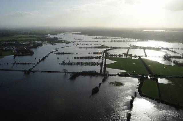
Advance of Southwest Monsoon 2026
❖ The Southwest Monsoon has further advanced into some more parts of westcentral & entire northeast Bay of Bengal, and some more parts of northwest Bay of Bengal, entire Nagaland, Manipur and Mizoram, some parts of Tripura, Assam and Arunachal Pradesh today the 7th June, 2026.
❖ The Northern Limit of Monsoon now passes through 17.5°N/60°E, 17.5°N/65°E, 17°N/70°E, Devgad, Koppal, Ananthapuramu, Chennai, 15.5°N/85°E, 22°N/90.0°E, Kailashahar, Lamding, North Lakhimpur and 29°N/95°E as on 7th June.
❖ Conditions are favourable for further advance of southwest monsoon into some more parts of central Arabian Sea, Maharashtra, Karnataka, some parts of Telangana, some more parts of Andhra Pradesh, remaining parts of Tamil Nadu & southwest Bay of Bengal and some more parts of westcentral & northwest Bay of Bengal, some parts of Chhattisgarh & Odisha, remaining parts of Northeastern states and some parts of Sub-Himalayan West Bengal & Sikkim during next 3-4 days.
#SouthwestMonsoon #Monsoon2026 #WeatherUpdate #BayOfBengal #NortheastIndia #IndianMonsoon #RainForecast #WeatherPatterns
@moesgoi @airnewsalerts @DDNational @ndmaindia @ICRER_MHA
3
90
569
35,293

El Niño Conditions This Summer Could Have "Sudden and Chaotic Impact" afloat.ie/marine-environment… #ElNiño #ClimateChange #WeatherPatterns #GlobalWarming #MarineEnvironment
91

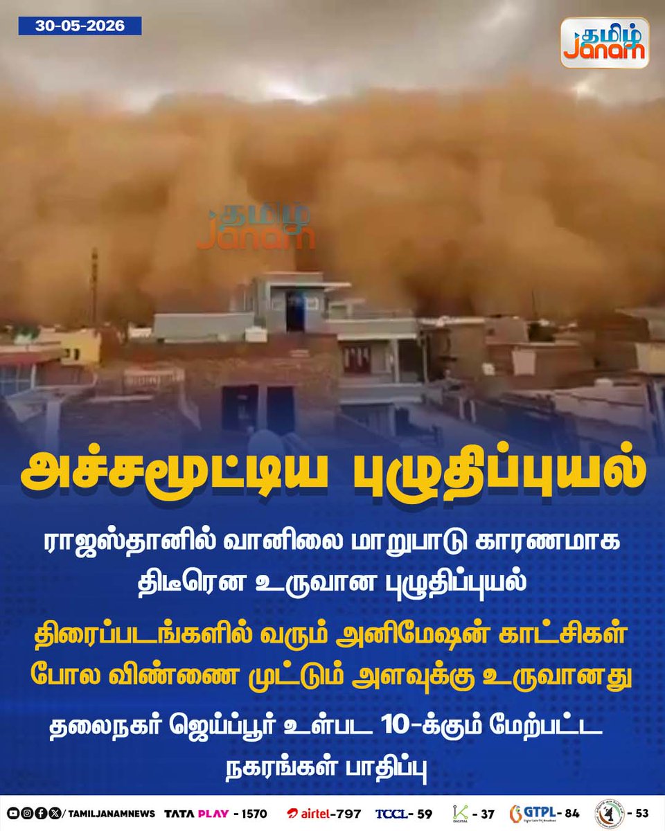
May 30
அச்சமூட்டிய புழுதிப்புயல்
#Terrifying | #DustStorm | #Rajasthan | #weatherpatterns | #Newsupdate | #TamilJanam
1
4
10
294

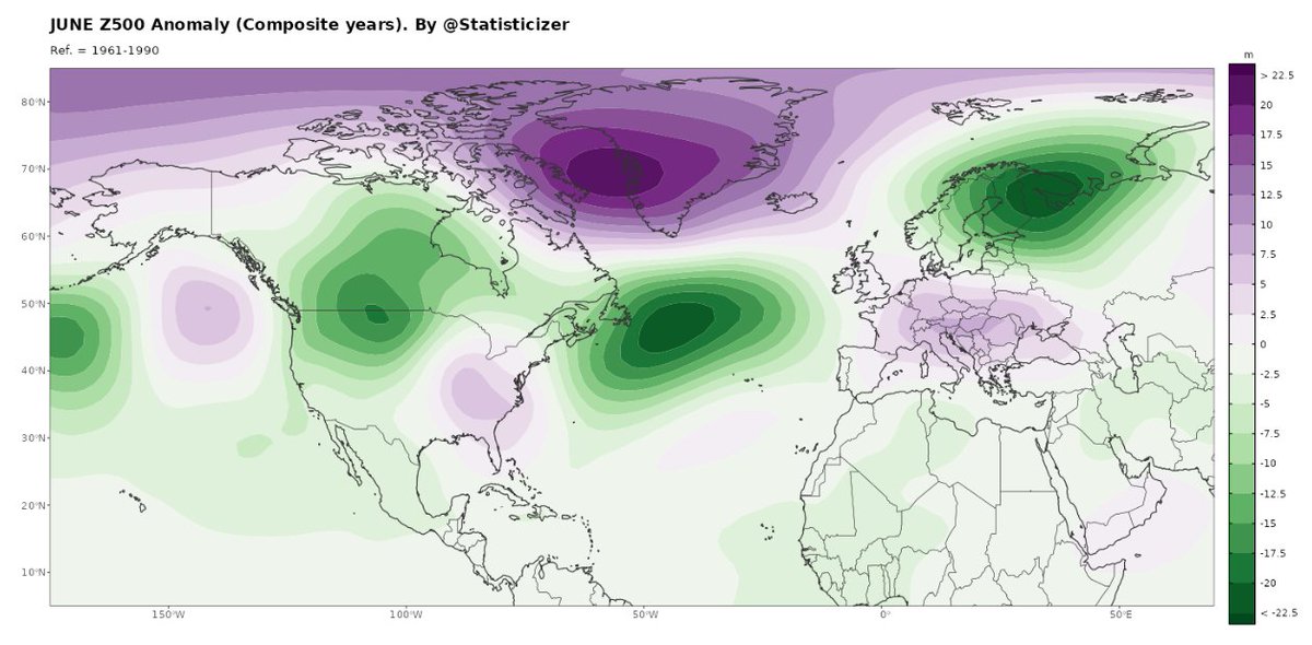
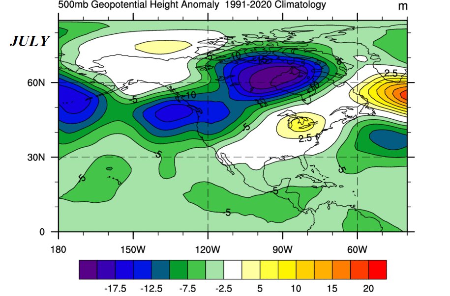
🌍📊 June Synoptic Outlook & Temperature Signals (Analog Composite)
A dynamically active Rossby wave regime is favored into June, following the omega-blocking pattern observed over North America in May.
🔷 Synoptic Pattern
Amplified, wavy jet stream
Persistent Greenland ridge (positive anomalies)
Downstream Atlantic troughing & Scandinavian disturbance
Tendency toward split-flow / multi-trough configurations
👉 This is not a stable summer pattern, but a wave-driven regime
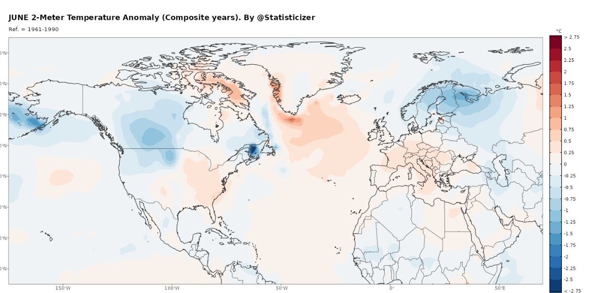
🌡️ 2m Temperature Outlook (Probabilistic)
🇪🇺 Europe
Neutral to slightly warm overall
Cooler anomalies over Scandinavia / NE Europe
Increased variability across Central Europe
Mediterranean prone to instability & transient lows
🇪🇸🇵🇹 SW Europe / Iberian Peninsula
Suppressed early-summer heat risk
Higher probability of Atlantic influence intrusions
Potential for:✔ intermittent cooling episodes
✔ cloudiness / unsettled conditions
Heat likely delayed or non-persistent
👉 Consistent with nearby Atlantic trough positioning
🇺🇸🇨🇦 North America
Mixed signals
Cool pockets central / western regions
Warmer anomalies toward NE Canada / Greenland sector
Continued influence from wave amplification
🇱🇧🇯🇴🇸🇾 Levant / Eastern Med
Near-normal to slightly warm
Not a persistent heat regime
Occasional intrusions from northern troughs
Potential for localized instability events
🔷 Greenland Signal (Key)
Strong positive Z500 anomalies
Acts as a blocking ridge anchor
Forces downstream wave amplification across the Atlantic–Europe sector
👉 This is a driver of the entire pattern
⚠️ Takeaway
June likely evolves under:
high-amplitude Rossby wave activity, not zonal summer flow
Expect:
variability /volatility in weather.
regional contrasts in 2-meter temperatures
episodic intrusions rather than sustained heat
The analysis had utilized 23 statistical analogs for current season, considering the ENSO latent growth, GLAAM, Blocking indexes and many other atmospheric and ocean SST indexes. The analysis is probabilistic Not deterministic, couple this view with numerical weather prediction models views for better prognostic analysis on weekly basis.
Statistical Model by Mr. M the chief data scientist @ hodhodata.com / @Statisticizer .
#Synoptic #WeatherPatterns #AnalogForecast #RossbyWaves #EuropeWeather #ClimateSignals
4
11
57
6,119

May 24
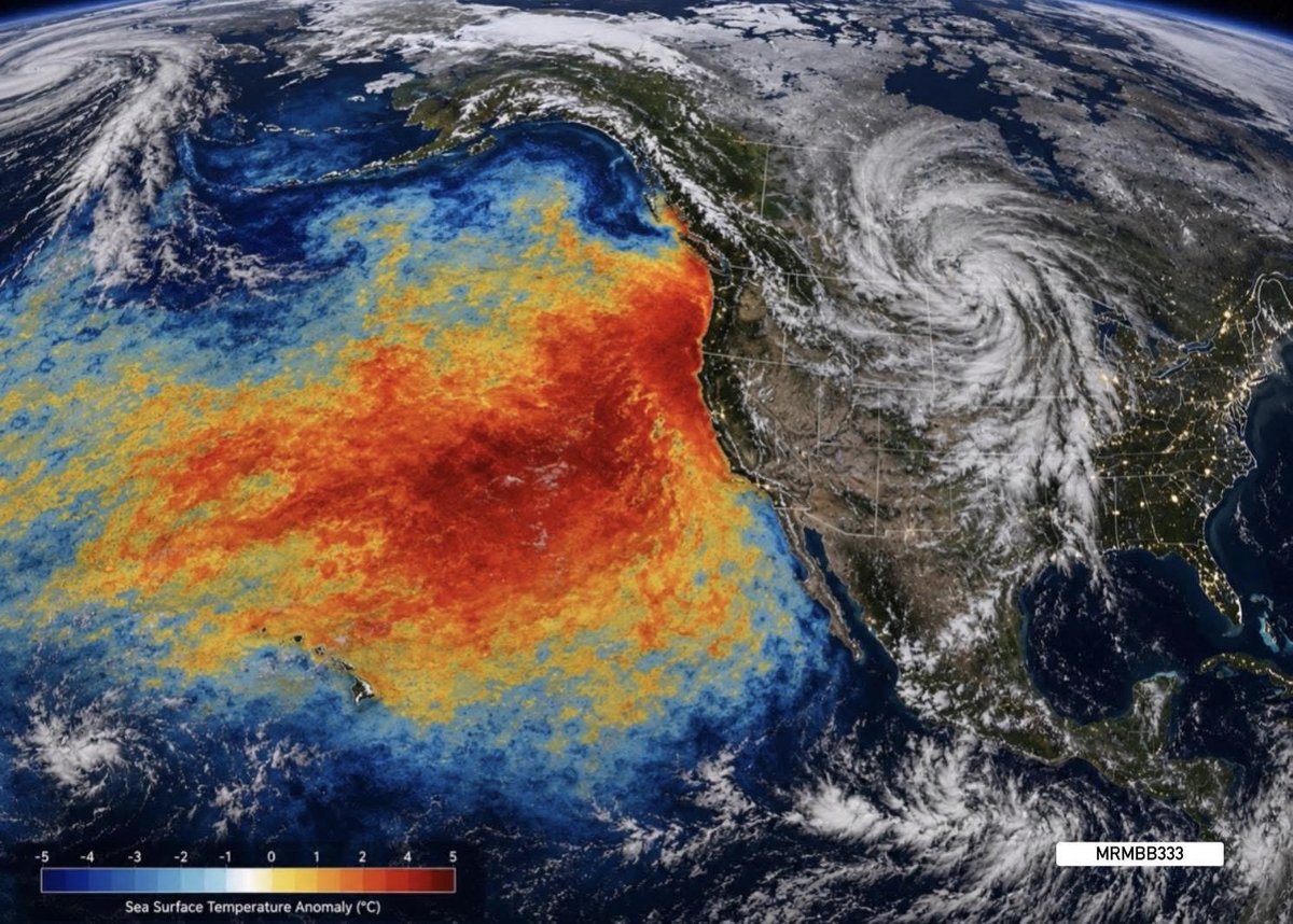
SOMETHING IS CHARGING THE ATMOSPHERE OVER THE PACIFIC ⚠️
A massive marine heat anomaly is continuing to expand across the Pacific Ocean right now — and conditions like this have historically been linked to some of the most unstable weather patterns on Earth.
When huge sections of the ocean stay abnormally warm for long periods of time…
the atmosphere above them can begin holding:
• more heat
• more moisture
• more energy
• more instability
That’s when patterns can start locking into place.
Storm systems stall.
Flooding repeats.
Heat becomes trapped.
Wildfire conditions intensify.
The atmosphere almost starts behaving like it’s under pressure.
And right now…
many people already feel like the weather has become more aggressive than normal.
Storms keep reloading.
Temperature swings feel extreme.
Weather systems refuse to move.
The growing heat in the oceans may now be feeding some of the strange weather behavior happening worldwide.
👇
Does it feel like the atmosphere has been acting different where YOU live lately?
#MrMBB333 #PacificOcean #heat #anomaly #ExtremeWeather #WeatherPatterns
61
191
563
73,344
May 23
⚠️ THE REAL DANGER ISN’T THE Ω PATTERN…
It’s what can start building underneath it.
Right now a massive Omega Block is starting to form over the U.S. — where the jet stream bends into a giant Ω shape and weather systems slow down dramatically.
But almost nobody is talking about what this can START DOING to the atmosphere below the pattern itself.
The longer these systems stall:
• the more heat can build
• the more moisture can build
• the more instability can build
• and the more “compressed” the atmosphere can become before finally snapping loose
That’s why some of the worst flooding events and severe weather outbreaks can suddenly explode AFTER days of repetitive weather.
The atmosphere above the U.S. is starting to look bottled up.
👇
Something about the weather lately feels different. Anyone else noticing it?
#MrMBB333 #ExtremeWeather #OmegaBlock #WeatherPatterns

63
185
641
36,206

May 22
Scientists are closely watching the possibility of a “Super El Niño” in 2026.
If it develops, it could impact:
* Heatwaves
* Monsoons
* Food prices
* Inflation
* Power demand
* Global growth
What happens in the Pacific Ocean can affect everyday life across the world.
Explained simply in this video.
Watch: youtu.be/RmpZhIqlDXI
@sonalbhutra
#SuperElNino #ElNino2026 #ClimateChange #WeatherPatterns #Heatwaves #cnbctv18digital
2
3
4,301

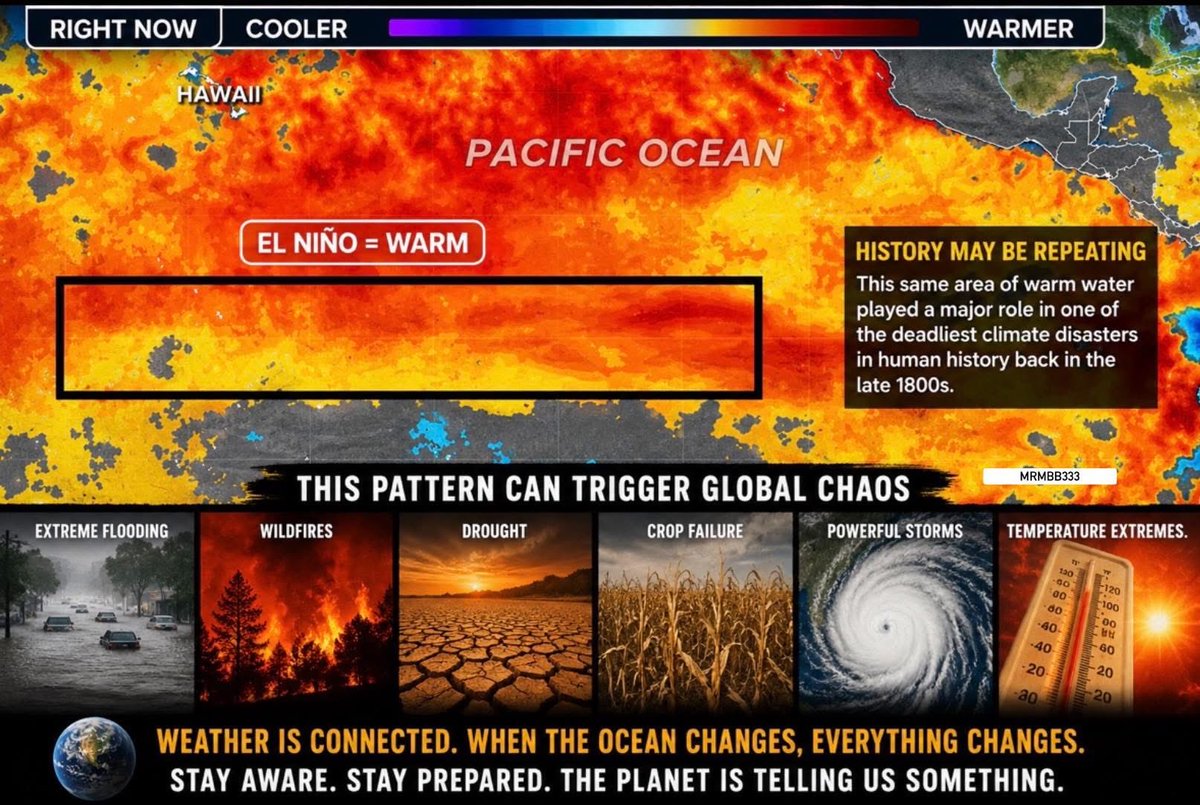
HISTORY MAY BE STARTING TO REPEAT ITSELF
Back in the late 1800s, an extreme El Niño helped trigger one of the deadliest global weather disasters ever recorded.
Now another powerful El Niño pattern is developing during a time of:
• record ocean heat
• historic flooding
• explosive wildfire seasons
• crop stress
• strange jet stream behavior
• massive temperature swings worldwide
This isn’t just about warmer water.
When these ocean patterns shift hard enough, weather across the entire planet can start behaving differently at the same time.
And many people feel like the atmosphere already has.
👇
Does the weather where you live feel more unstable lately?
MRMBB333
#MrMBB333 #ElNino #ExtremeWeather #EarthChanges #WeatherPatterns #EarthWatch
3
4
11
1,445
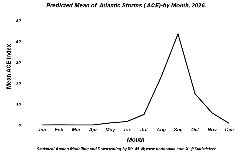
🌪️📊📡Atlantic & Pacific Hurricane Season Outlook , Summer and Autumn 2026- (Analog-Based) #North_America #hurricanes.
Much of the current narrative pointing to a weak 2026 hurricane season is driven by social media hype around a “super El Niño,” but this appears temporally misaligned.
The available signals suggest a later ENSO peak toward December, not during the core summer months when Atlantic activity is most affected .
The outlook here is based on a 32-analog ensemble (1860–2025) used to reconstruct 500 hPa patterns, derived from a multivariable statistical framework that integrates multiple sources of climate forcing, offering a more grounded perspective beyond simplified ENSO assumptions.
The large-scale analog signal continues to support a near-normal to slightly above-normal Atlantic hurricane season, despite ongoing narratives of suppression due to a potential El Niño.
Key driver: the expected ENSO peak is late (Dec–Jan) → meaning limited shear impact during the core season (Aug–Sep).
Monthly Evolution (Atlantic & NPA context)
July
NPA: modest troughing, transitional flow
MDR: gradually organizing
Storm zones: Caribbean, W. Atlantic
→ Early-stage activity, not yet dominant
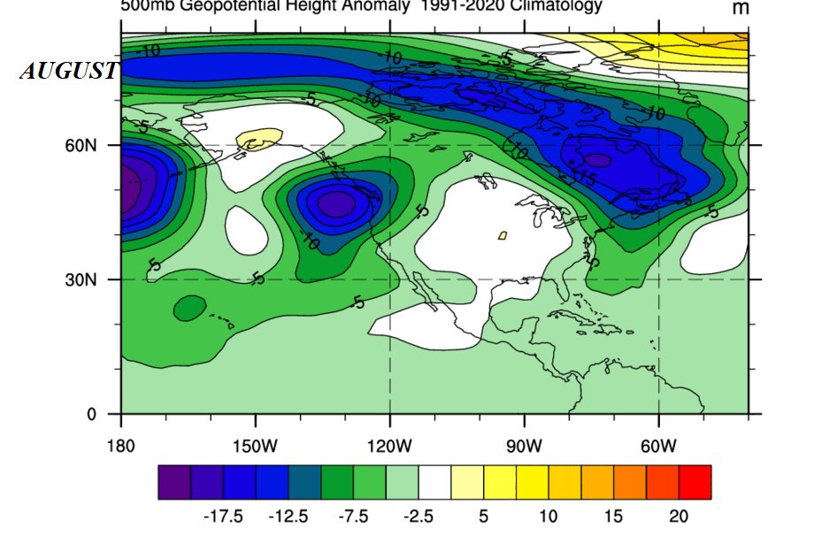
August
NPA: deeper trough into W. North America → reduced Atlantic shear windows
MDR: ridge strengthening, improving wave propagation
Storm zones: MDR → Caribbean → Bahamas
→ Clear ramp-up phase
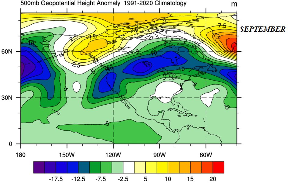
September (Peak)
NPA: structured waveguide, balanced ridge–trough pattern
MDR: fully active, low shear pockets
Storm zones: Cape Verde → long-track hurricanes → W. Atlantic re-curvature
→ ACE peak aligns with climatology
October
NPA: increased trough penetration southward
MDR: weakening, shift westward
Storm zones: Caribbean, Gulf, W. Atlantic
→ Higher land-interaction & hybrid systems
November
NPA: trough-dominated regime
MDR: suppressed, activity contracts
Storm zones: Western Caribbean focus
→ Late-season residual activity
Pacific (Brief)
Eastern Pacific likely near-normal to slightly active early, with activity modulated by evolving ENSO structure
Gradual shift in activity distribution as the season progresses, with less coherent suppression signal than typically assumed
🎯The Punch line :
The synoptic evolution ACE analogs closely match climatology, particularly the September peak.
There is no strong signal for a suppressed Atlantic season at this stage. The expected ACE indices sit near the climatological average expected for the like seasons ( neither much less nor much more ) .
If El Niño develops, its main atmospheric imprint is likely delayed into late 2026 and early 2027, not during peak hurricane months.
❗️The October and November expected 500 hpa synoptic maps and storm track detailed monthly interpretation are added in the comments.
Other forecasts for the atlantic region had also been post in the comments-from the last week.
Warmest Regards,
Statistical Analog Modelling & Downscaling By Mr. M @Statisticizer. / hodhodata.com , Irbid -Jordan.
___________________
#AtlanticHurricaneSeason #HurricaneSeason2026 #TropicalCyclones
#ACEIndex #ENSO #ElNino #ClimateSignals
#NorthPacific #MDR #WeatherPatterns
#HurricaneForecast #LongRangeForecast #ClimateAnalysis
#EarlyWarning #DisasterPreparedness
3
7
33
5,756

Apr 6
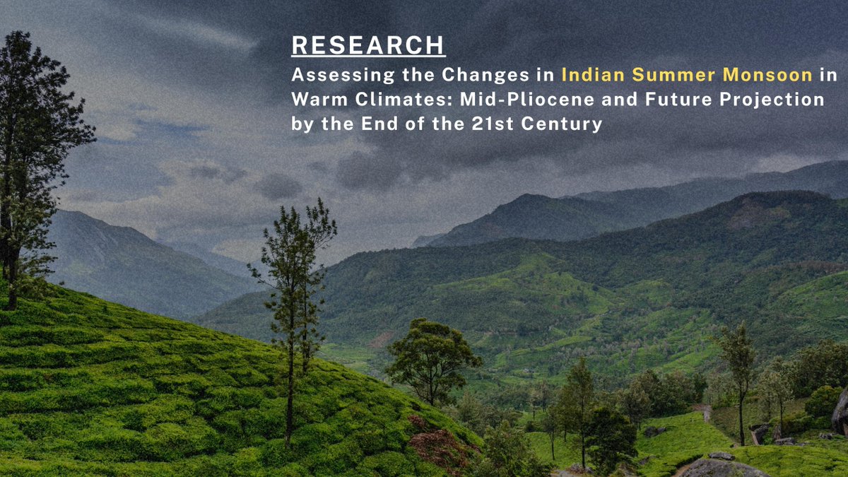
Researchers Explore the Altering Effects of Global Warming on the Indian Summer Monsoon!
Prof. Nagaraju Chilukoti and Dr. Karishma Dahiya (Research Graduate) from the Department of Earth and Atmospheric Sciences at NIT Rourkela, in collaboration with Prof. Raju Attada (IISER Mohali), analysed how the monsoon behaved during warmer periods in Earth’s past to understand how it might behave in the future.
Their study has been published in the prestigious International Journal of Climatology (rmets.onlinelibrary.wiley.co…).
The study shows that monsoon rainfall over India was higher during the mid-Pliocene period (around three million years ago), and a similar increase is expected in the future due to a warmer climate. Given the monsoon’s strong impact on human livelihoods, it is important to understand how the Indian monsoon might respond. These findings are important for climate preparedness, agriculture, and water management in India and nearby regions.
More Details:
🗞️Deccan Helard: deccanherald.com/india/monso…
🗞️TNIE: newindianexpress.com/xplore/…
🗞️ETV Bharat (Odia): etvbharat.com/or/state/nit-r…
🗞️Dainik Bhaskar: bhaskarhindi.com/other/globa…
🗞️BW Education: bweducation.com/article/nit-…
🗞️Dainik Jagran: jagran.com/odisha/bhubaneshw…
🗞️Northeast Now - nenow.in/environment/warmer-…
@EduMinOfIndia @moefcc
#NITRourkela #IndianMonsoon #GlobalWarming #ClimateChange #MonsoonResearch #ClimateScience #ResearchUpdate #EnvironmentalScience #FutureClimate #WeatherPatterns #India #ScientificStudy #ClimateImpact #EarthScience #MonsoonStudy
1
6
316

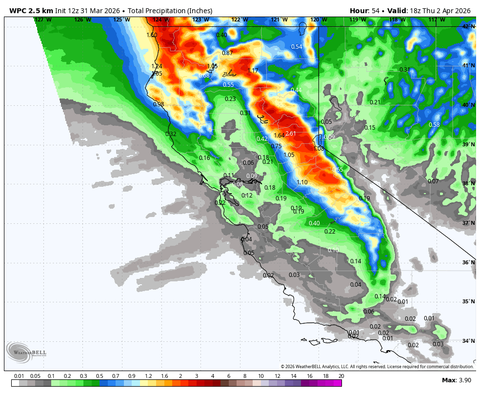
Mar 31
FYI Followers, if you are tracking the snow in the Sierra and Tahoe today. Again, it has been so hard to get sustained cold out west, and again, it will rebound starting tomorrow to another warm extended period. The rain below 7500', might be the kills shot for more ski resorts just barley hanging on to stay open. What a depressing year!!!!
My thoughts from Yesterday - x.com/realwxforecast/status/…
#California #SoCalWeather #WestCoastWeather #Meteorology #RossbyWaves #PolarVortex #SSW #WeatherPatterns #SierraNevada #Snowpack #SpringWeather #ClimatePatterns #ENSO #ElNino #SkiSeason #MountainLife #ForecastDiscussion #socal #cawx
Mar 31

The models have been trending wetter, with up to 2" of precip near the crest by Thu morning. Snow levels fluctuating mostly between 7-8k before falling below 6k Wed night. A coating up to several inches of wet snow for the lower mountains, & 6-21 inches above 8k'.
2
27
3,843
Mar 30
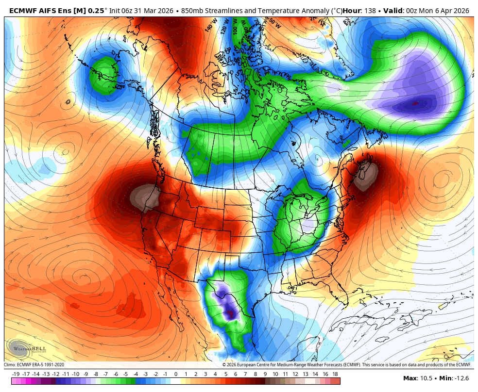
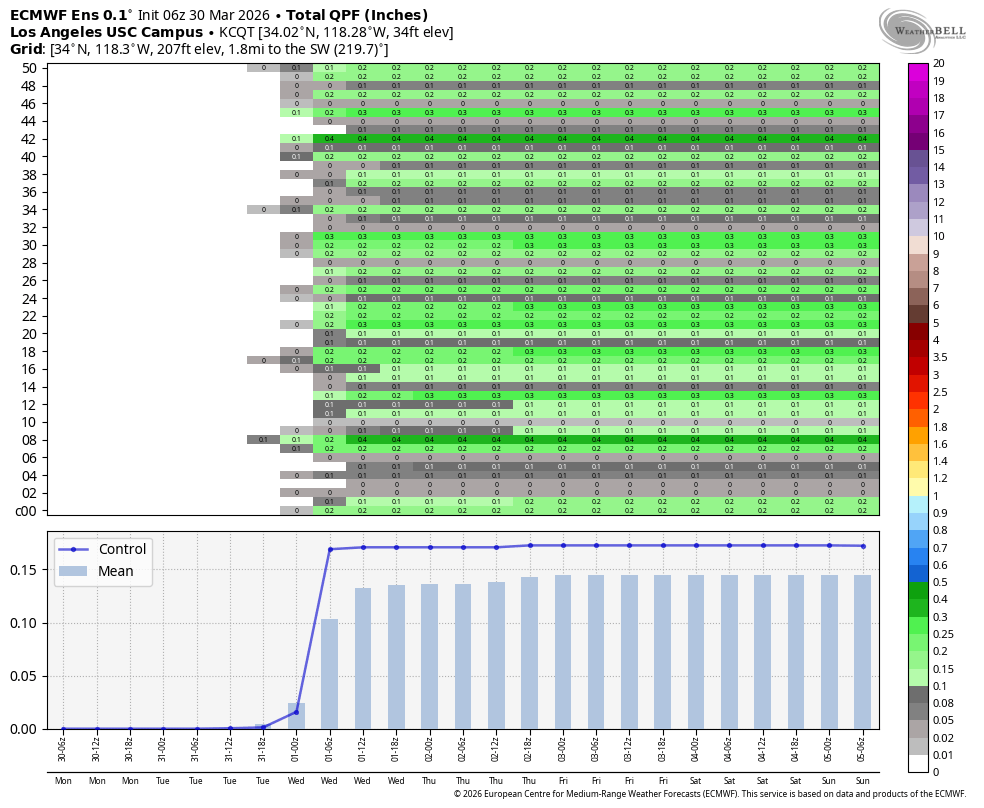
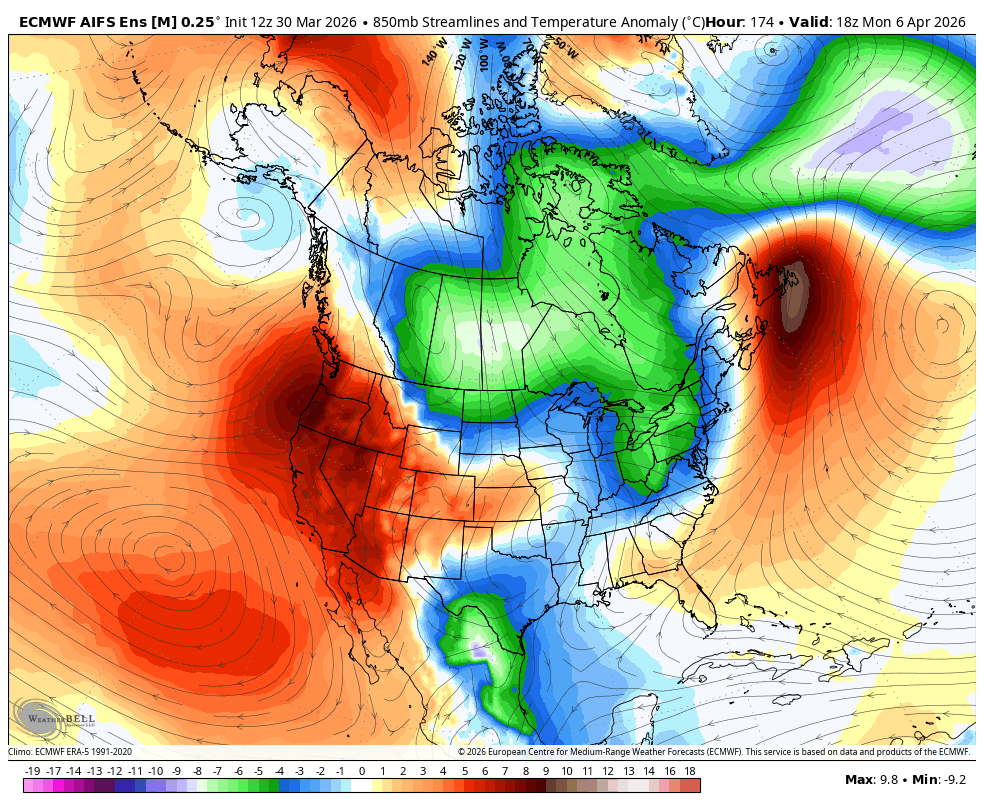
Followers — quick update with my AI weather discussion tool below. Enjoy -
This week’s storm — yes, there’s rain… but let’s be real about it. You can already see it in the forecast image below from the Euro Ens AI, there is a window for some light precip into #SoCal.
But again… context matters.
→ Scattered showers, nothing organized
→ No real moisture tap
→ No sustained forcing
So yeah — some areas will see light rain, maybe a quick burst here and there…but under .25" from what I am seeing south of Pt. conception. However, this is nowhere near a meaningful, season-saving event.
This is nuisance-level precip for most of Southern California.
Now let’s talk about WHY — Rossby waves & pattern interference. This is where it actually gets interesting.
This weekend’s system and every system this winter out west, has been getting completely disrupted by the larger-scale pattern, and it comes back to Rossby wave behavior. Some Omega blocks and meridional flow, as I have discussed over and over again this winter, it is the culprit. This is due to the SSW and PV, constantly stretching and reloading back east. Look at this temps and their weather currently in NY. Cold folk!
What we needed:
→ A clean, amplified Rossby wave digging into the West Coast
→ Strong downstream support
→ A consolidated trough with depth and duration
What we got instead:
→ A fragmented / flattened Rossby wave train
→ Energy getting stretched and sheared east
→ Weak undercut of the ridge instead of a full breakdown
And this ties back to the bigger season-long issue:
→ The polar vortex has been displaced and elongated eastward
→ Residual impacts from earlier stratospheric warming (SSW) disrupted the flow
→ That interference has kept the West Coast from locking into a sustained trough pattern
Translation (non-weather speak):
Every time a storm tries to organize and dig into California…
→ It loses structure
→ It loses support
→ It falls apart as it moves in
That’s exactly what’s happening this week.
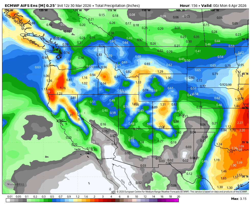
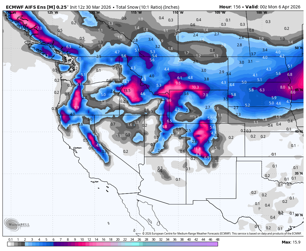
Mountains — quick hit (because this matters too)
Yes — this system will bring:
→ Snow above ~9,000 ft
→ Maybe up to ~1 foot in the highest elevations
Check out @TahoeWeather for the full report of what snow the resorts that are still opened, might get in #california. Folks, it is bleak. Again, winter has been over for weeks, as most of the resorts west of the divide, are either closed or hanging on for dear life.
That might help preserve some upper mountain terrain briefly.
But again…
→ Lower elevations? Not much help
→ And right after? Warmth returns melt resumes
And speaking of that…
Right behind this system:
→ Heights rebound
→ Ridge builds back in
→ Temps spike again
So whatever rain/snow we get?
Short-lived.
Resorts — same story, just getting worse
And this is where reality hits.
I was supposed to be at Deer Valley Resort right now…
…but they’ve already closed.
And they won’t be the last.
→ Palisades Tahoe — lower mountain done
→ Alpine Meadows — closed
→ Mammoth Mountain — hanging on up top
→ Park City Mountain Resort — likely next
- Beaver Creek closed yesterday.
Everyone is trying to make it to Easter…
Not everyone will.
Bottom line
→ This weekend’s system = weakened by Rossby wave interference
→ Rain into #SoCal = light, scattered, limited impact
→ Sierra snow = mostly above 9,000 ft, short-lived benefit
→ Ridge returns quickly → warming resumes
→ Pattern still favors weak troughs dominant ridging
→ Winter out west? Pretty much done outside of the highest elevations
Same message, just more confirmation.
The pattern hasn’t changed — just the timing.
So there ya go. There is my weather AI discussion. Folks, as you know I have transitioned to golf, hiking and train riding. Some places, per the models below, will be back to summer in #california next week.
Wish I had better news......More later....
P.S. - I will have an update on the palisades mountains and pictures later this week. Amazing how the landscape has changed from the fires.
#California #SoCalWeather #WestCoastWeather #Meteorology #RossbyWaves #PolarVortex #SSW #WeatherPatterns #SierraNevada #Snowpack #SpringWeather #ClimatePatterns #ENSO #ElNino #SkiSeason #MountainLife #ForecastDiscussion #socal #cawx
4
3
41
3,032

Mar 30
Politicians are chasing swing states. The climate is redrawing the map. India’s 2025 climate map reveals another reality on the ground: some regions are drying out, while others are being drenched.
#ClimateChange #IndiaClimate #GlobalWarming #ClimateCrisis #WeatherPatterns #ClimateImpact

3
11
1,210

It’s deep. The attack comes as we do NOTHING for our country is to busy fighting fake wars and fixing fake problems. 3 months ago weather forecasters predicted this as EL Nino is most extreme EVER as a new discovery of warm water at depth in the ocean is rewriting weatherpatterns
2
191

Many people across India have been noticing sudden weather changes lately—but does that mean something artificial is driving it?
x.com/PTI_News/status/203519…
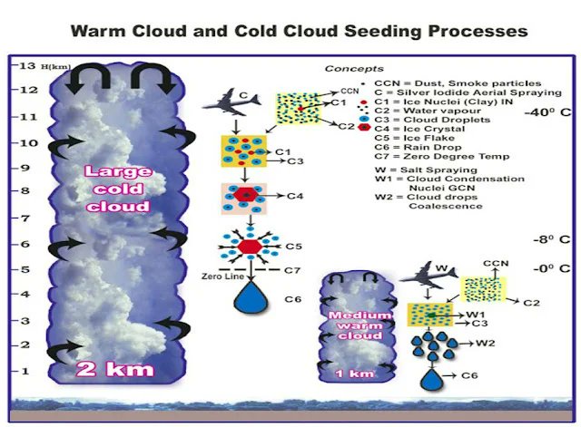
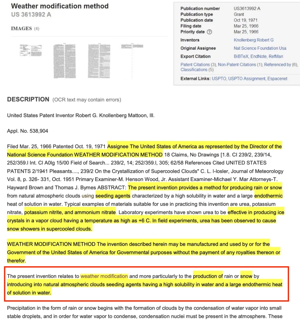
Climate engineering, also known as geoengineering, is the deliberate and large-scale intervention in the Earth’s climate system. These interventions are aimed at combating so-called climate change or mitigating its effects. One method employed by climate engineers is the use of chemical ice-nucleating materials to cool down surface temperatures. When there is enough atmospheric moisture present, these materials can create extreme and sudden cooling effects, leading to the formation of dense fog.
The extensive use of chemical ice-nucleating materials by climate engineers has resulted in the development of more severe and prolonged fog conditions. This is not mere speculation; it is a verifiable fact supported by patented processes of climate modification and laboratory testing. The abrupt cooling caused by these materials has the potential to trigger extreme and lingering surface fog scenarios.
#ClimateChange #Geoengineering #WeatherModification #ClimateEngineering #ArtificialWeather #FogFormation #IceNucleation #EnvironmentalImpact #ClimateCrisis #WeatherPatterns #ClimateScience #AtmosphericChanges #ChemicalIntervention #GlobalWarming #ClimateAwareness #EcoFriendly #ClimateAction #AirPollution #AlzheimersRisk #BanGeoEngineering #StopCloudSeeding #SolarRadiationModification #StratosphericAerosolInjection #MarineCloudBrightening #AirToxicity #EnvironmentalHealth #ToxicAerosols #AluminumToxicity #HealthRisks #BillGates #cloudseeding #chemtrails #SCoPEx #EpsteinFiles #Epstein #Aluminum #AluminumOxide #SRM #chemicals #SAI #bariumtitanate #toxic #nanoparticles #MCB #weathermodification #AQI #Delhi #informedconsent
@awakenindiamvmt @DrDev7 @DeeEternalOpt
Mar 21

VIDEO | Fog engulfed parts of Delhi during early morning hours. Visuals from Vikas Nagar.
(Full video available on PTI Videos - ptivideos.com)
3
19
23
709
STOP GEOENGINEERING!
Weather modification using chemicals can cause climate change, leading to cloud disappearance, storm formation, snowfall, increased rainfall, rising temperatures, and hail occurrences.
x.com/TOIBengaluru/status/20…
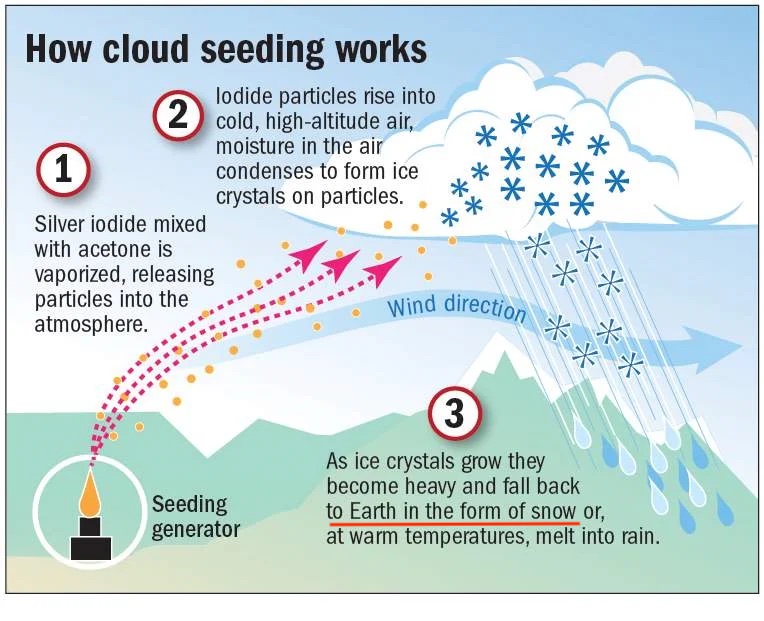
How does cloud seeding work?
1. lodide particles rise into high-altitude air, and moisture in the air condenses to form ice crystals on the particles.
2. Silver iodide mixed with acetone is vaporized, releasing particles into the atmosphere.
3. As ice crystals grow, they become heavy and fall back to Earth in the form of snow or, at warm temperatures, melt into rain.
Stop Cloud Seeding!
#climatechange #cloudseeding #weathermodification #Karnataka #Machapur #MiniKashmir #Hailstorm #Dharwad #ClimateChange #StopGeoengineering #WeatherModification #CloudSeeding #SilverIodide #EnvironmentalAwareness #NaturePhotography #IndianVillages #SustainableLiving #WeatherPatterns #ClimateAction #SaveOurPlanet #EcoFriendly #HailDamage #WeatherNews #Kalghatgi #hubli #dharwad #india #Silveriodide @awakenindiamvmt @DrDev7
Mar 17
When a #Karnataka village turned into mini-#Kashmir this summer!
A severe #hailstorm struck Machapur & nearby villages around Kalghatgi in Dharwad district 👇 on Tuesday,
Cloudy weather & drizzle predicted in #Bengaluru for next 2 days
@timesofindia

8
7
187

Mar 15
Glad to have had this radio Talkshow discussion alongside my elder Mr. Kule Walyuba the team leader at Kiwa Heritage.
He was able to articulate indigenous knowledge and practices communities can leverage to turn the status quo.
#PlantingSeason #WeatherPatterns #Kasese_Uganda

Great discussion today on @1005kgr abt the start of the planting season & changing weather patterns in Kasese.
We discussed mistakes farmers should avoid, climate-smart farming & the value of indigenous knowledge around the Rwenzori Mountains.
#ResistanceEarth #wtpEarth #ActNow


2
2
48

Mar 5
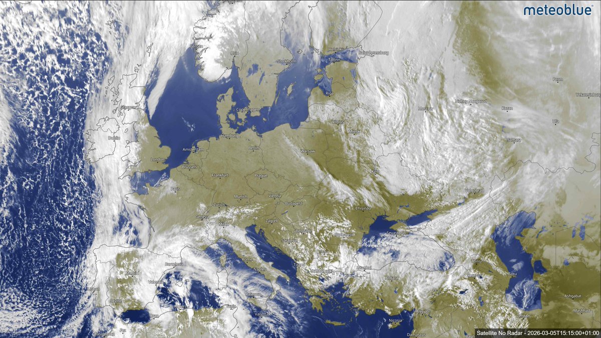
If you ever wondered what an anticyclone looks like from space…🛰️🌍
The current satellite imagery offers a clear illustration of a classic large-scale atmospheric pattern across Europe. Much of western, central and parts of eastern and northern Europe are currently under the influence of Anticyclone Jannis, a high-pressure system bringing stable and largely sunny conditions.
➡️ From a satellite perspective, anticyclones often appear as broad regions with relatively few clouds. High pressure is associated with subsiding air, meaning air slowly sinks through the atmosphere. As it descends, it warms and dries, suppressing cloud formation and allowing clear skies to dominate. This is why large areas from France through Germany to Poland are currently experiencing bright conditions and mild early-spring temperatures. In many regions, daytime highs are reaching the mid-teens Celsius, with even warmer values locally.
➡️ Anticyclones also tend to bring light winds and stable air masses, which is why weather patterns can remain relatively unchanged for several days. Under clear skies, daytime sunshine can feel pleasantly warm, while nights may still cool significantly due to efficient radiative cooling.
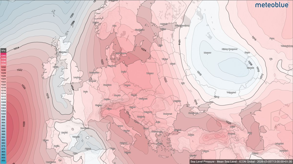
🔺 However, the broader European weather pattern also shows the contrast between high and low pressure systems. Over south-western Europe, a low-pressure field is influencing conditions across the Iberian Peninsula and parts of Italy. Here, rising air encourages cloud development and precipitation, leading to unsettled weather.
🔺 Particularly along the eastern coast of Spain, including the region of Catalonia, heavy rainfall is expected over the coming days. Forecasts indicate rainfall totals of 50–100 mm, with locally higher amounts possible. Weather warnings have been issued due to the potential risk of flooding and landslides.
Satellite imagery, together with precipitation and pressure maps, helps reveal these large-scale atmospheric structures and how they shape the weather we experience on the ground.
Check the latest meteoblue Satellite Maps 👉meteoblue.com/en/weather/map…
#Weather #Meteorology #EuropeWeather #WeatherPatterns #meteoblue

12
465

Die hael wat onlangs verwoesting in die Koue Bokkeveld gesaai het, het heelwat later in die seisoen gebeur as wat vantevore ondervind is. Tot 100% appel- en peer-oeste het deurgeloop. 🌨️
landbou.com/bedrywe/tuinbou/…
#climatechange #weatherpatterns
1
32