#30DayMapChallenge Day 20 — Water 🌊
Navigating smarter, not harder.
The @Sofarocean Wayfinder Voyage Simulator, built with Mapbox, lets captains and operators test and compare ocean voyage plans in real time. It runs full-physics simulations in the browser using vessel models and live forecast data — so users can adjust routes, tweak power, and instantly see the impact on ETA, fuel, and weather.
Learn more about how they built it here: sofarocean.com/posts/how-the…#BuiltWithMapbox#MaritimeTech
⚡️The Wayfinder Voyage Simulator leverages world-class weather forecasts vessel‑specific performance models that are updated daily.
🎥 Join our live webinar to learn why we built it: sofarocean.com/posts/webinar…#marineshipping#sofarocean
#SofarOcean buoy 1317 measured peak seas of 13.8 m or 45 ft around midnight last night as Hurricane #Erin passed within ~60 nm to the northwest of the buoy. Large swell will continue to impact the eastern seaboard with high surf for the next few days.
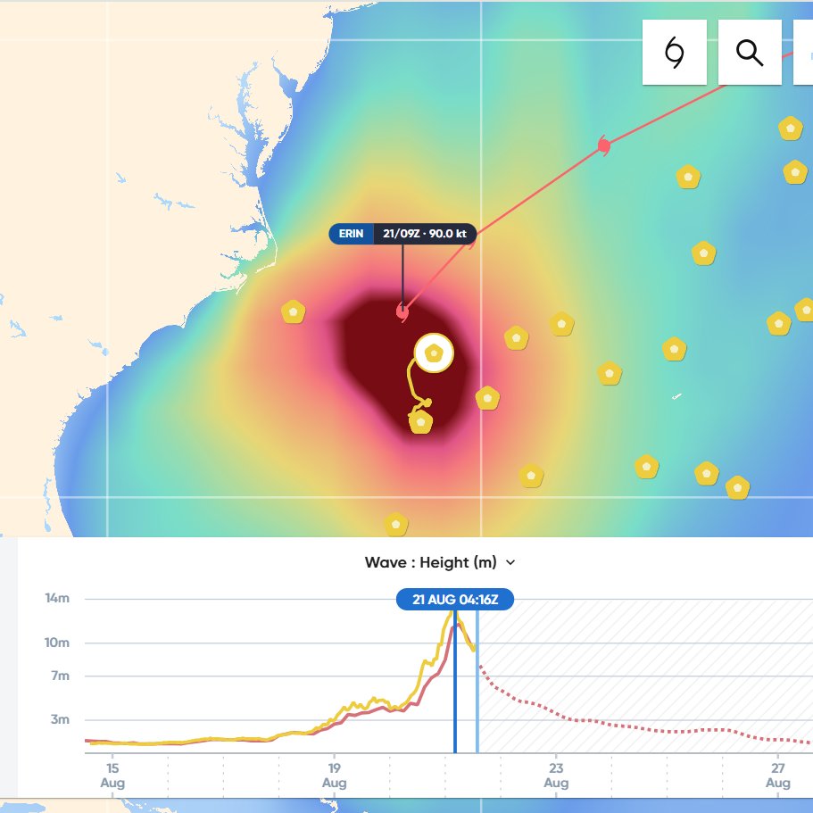
ALT Sofar Ocean weather dashboard showing 0900 UTC location of Erin, and Spotter buoys (yellow hexagons) in the region. Time series of measured wave heights at bottom shows peak seas of 13.8 m occurring last night at 0416 UTC, with dominant swell from the south at 13-17 seconds.
Pre-deployment activities are underway at the Biscay Marine Energy Platform! Following recent site works, new wave buoys were deployed yesterday in preparation for #CETO. These small but mighty @Sofarocean wave buoys will give valuable live streamed data
$CCE | $CCE.AX | $CWGYF
Chairman @RepFranklin thanked the witnesses from @Sofarocean, @Oceaneering, @xoceansocial, and @UCSanDiego after yesterday’s Environment Subcommittee hearing.
Strong public-private partnerships drive innovation in the ocean industry now and in the future.
During our Environment Subcommittee hearing, Dr. Tim Janssen, CEO of @Sofarocean, emphasized the importance of developing technologies to enhance our understanding of the oceans and their crucial role in our nation's success.
⬇️
"The world’s ocean covers over 70% of the planet’s surface, and ocean industries drive 3.5% of world GDP. In the United States alone, the Blue Economy contributes almost $400 billion to the nation’s gross domestic product (GDP)."
- CEO of @Sofarocean, Dr. Tim Janssen
🌊 Aqualink is thrilled to present at BristleCon 2025, happening Jan 23-24 at @SofarOcean HQ! Join ocean enthusiasts for two days of workshops, networking, and shaping the future of ocean tech with Bristlemouth, the “USB for the sea.”
🎟️ Register early: lu.ma/cjixmuxm
Strong low pressure across the W #Atlantic continues to generate large N to NW swell moving into the area waters, with peak seas higher than 20 ft. #SofarOcean buoys and #Saildrone obs show a large area of seas 12 ft and greater. This swell will reach 20N and then beyond on Sun.
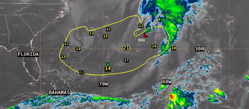
ALT GOES-16 IR image from 1800 UTC showing location of 994 mb low pressure center across the W Atlantic and cold front extending SW and into northern Cuba. Yellow contour identifies area of seas 12 ft and greater, with wave height observations in yellow numerals.
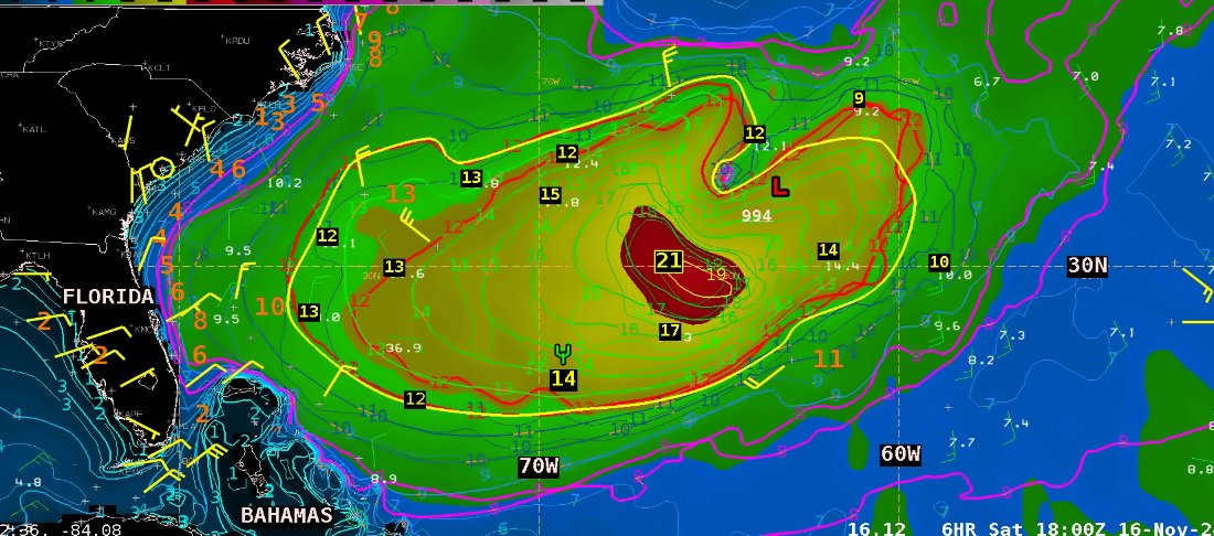
ALT Color image of GFS wave height forecast valid 1800 UTC, with wave height contours of GFS and ECMWF wave models overlaid in fine lines, with red lines indicating 12 ft. Thick yellow contour identifies area of seas 12 ft and greater, with wave height observations in yellow numerals (feet), with estimated maximum seas of 21 ft. Green goalpost symbol shows location of Saildrone 1041 at 17Z measuring seas of 4.2 meters.
ALT Same contour for 12 ft seas and wave observations as previous images, overlaid on 1400-1500 UTC ASCAT scatterometer wind data. Red colored flags indicate wind speeds of 30-33 kt and dark blue flags indicate 34-38 kt. Bermuda is located just NW of the low center.