
23 Oct 2025
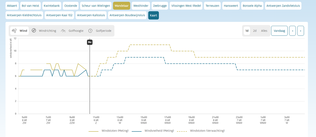
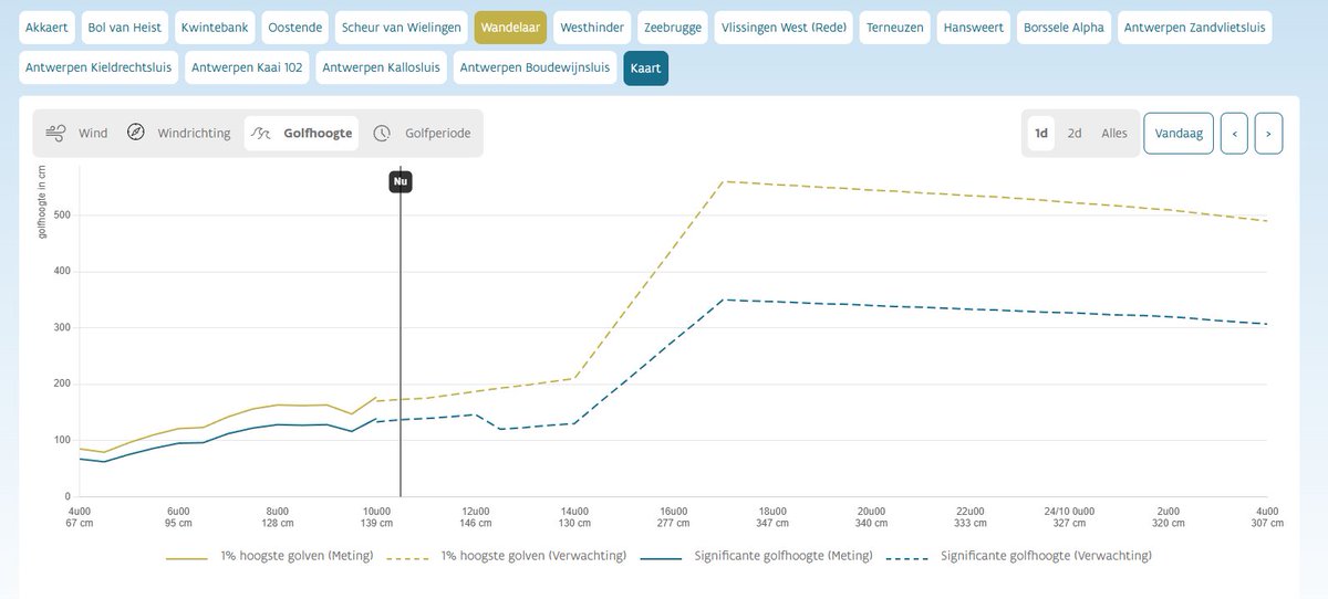
Storm at sea. Predicted winds Force 9 at Wandelaar Pilot with gusts up to Force 11. Significant Waveheight 3,50m with 1% up to 5,8m. Flushing roads Force 10 expected
4
3
58
7,178

9 Oct 2024
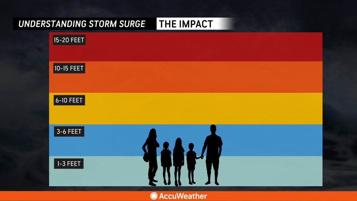
The expected wave height when Hurricane Milton makes landfall is 15-20 feet.
#HurricaneMilton #Landfall #StormSurge #WaveHeight #ExtremeWeather #BreakingNews
1
3
1,329

18 Sep 2024
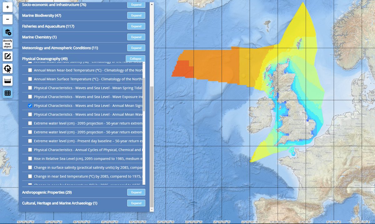
Add this physical characteristics layer of annual mean significant wave height during your searches for data in the MEDIN portal!
This #WMSWednesday is a layer from Atkins 👇🌊
hubs.la/Q02Nk4xG0
#sealevel #waveheight
2
63

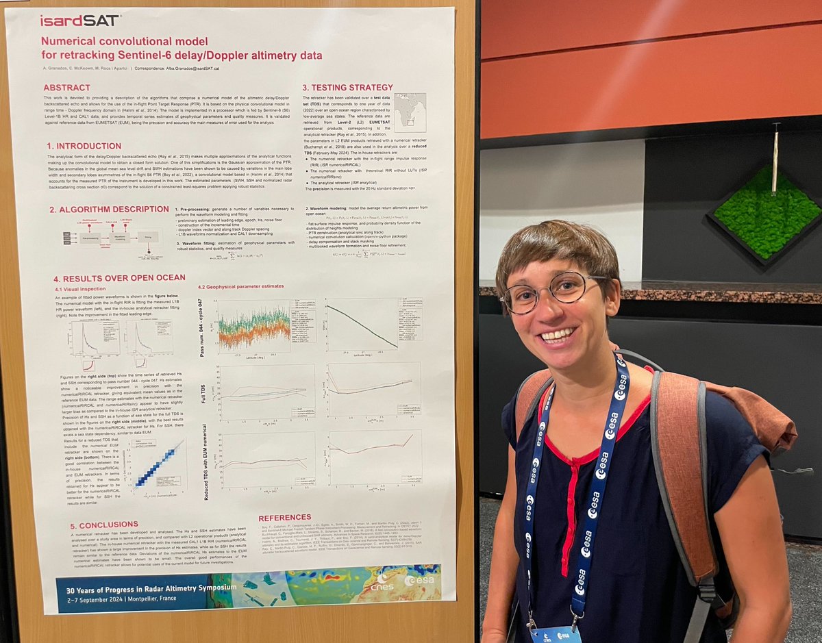
At #30YPRA Symposium, we presented a numerical convolutional model for #Sentinel6 #altimetry data that is able to improve the precision of significant waveheight estimates 🌊 and correct anomalies in global mean #sea level drift🛰️📈
More info 🔗isardsat.cat/project/s6-pose…
5
157

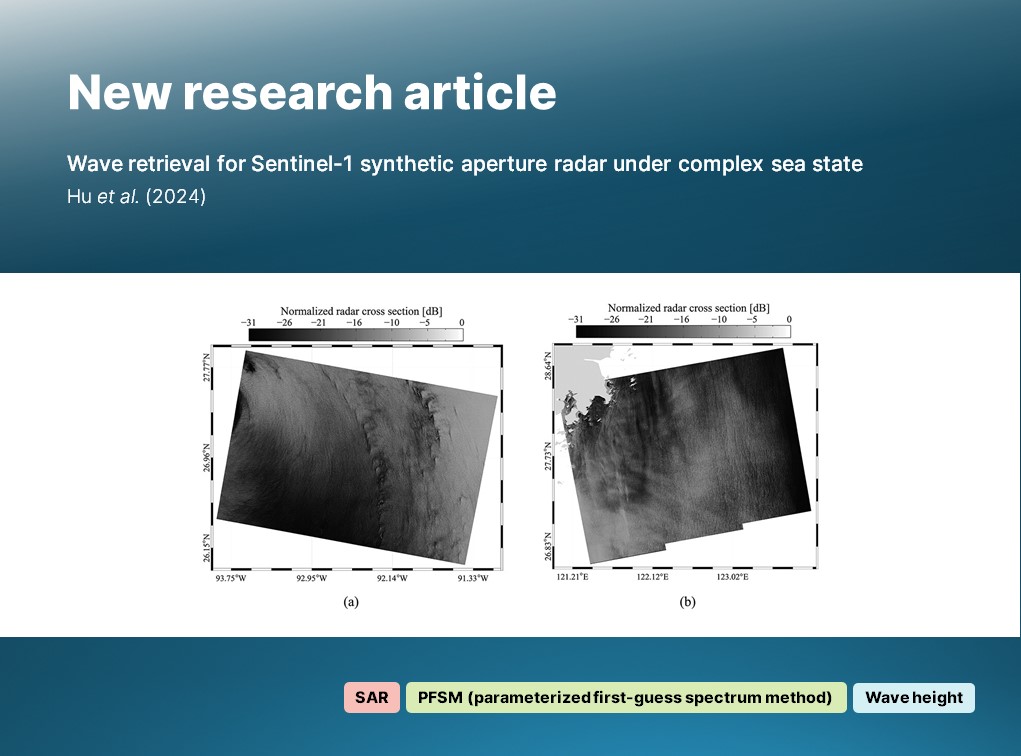
🔔 New article:
Hu et al. examine and retrieve sea surface #wave heights during complex sea states (i.e. tropical #cyclones) using dual-polarized (VV and VH) #Sentinel1 🛰️ #SAR imagery.
🔗 doi.org/10.1080/01431161.202…
#IJRS #RemoteSensing #SyntheticApertureRadar #WaveHeight
1
4
240

12 Apr 2024
I suspect this to be a mere case of Sensor Error translating to an INT16 maxing out at FF aka 255, which would perfectly fit to a waveheight of 25,5m if stored at 0,1m precision.
1
1
4
6,461

13 Feb 2024
is this anything close to the supplied function:
for(float elevation, iteration, scale, waveHeight, positionModifier, globalOffset, horizontalDisplacement; iteration < 90.; offsetIncrement = .01 - .02 / exp(max(scale, elevation) * 3000.) / horizontalDisplacement) {
vec3 point = vec3((frameCoordinates.xy - .5 * resolution) / resolution.y * globalOffset 2., globalOffset);
point.zy *= rotate2D(.5);
elevation = point.y;
horizontalDisplacement = elevation point.x * .3; point.z = time; // Assuming 't' is a time variable
for(scale = .6; scale > .001; scale *= .7) {
point.xz *= rotate2D(5.);
positionModifier = (point.x point.z) / scale time time;
elevation -= waveHeight = exp(sin(positionModifier) - 3.) * scale;
horizontalDisplacement = abs(dot(sin(point.xz / scale * .3) * scale, resolution / resolution));
}
globalOffset = elevation = min(elevation, horizontalDisplacement * .5 - 1.); }
2
36
55,213

15 Jan 2024
At6AM local time earlier today, Reunion Island was placed on purple alert, the highest level meaning imminent danger, as the #BelalCyclone runs through it
Just looking at #WaveHeight gives an idea of the gravity of this extreme event 👇
Our thoughts are with the people in Reunion
3
9
973

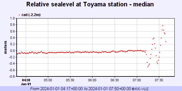
1 Jan 2024
Significant tsunami waves appear to be incoming (peak to peak waveheight of 1.5 m) at Toyama sea level station due to M7.5 earthquake near west coast of Japan
2
67
139
17,348

Oh #Buoy! Our research team recently installed a new real-time SoFar #DataBuoy at East Flower Garden Bank with the help of the @marinesanctuary and Xinping Hu from TAMU-CC .
This provides offshore #WaveHeight, #WindSpeed, and #WaterTemp.
spotters.sofarocean.com/?spo…
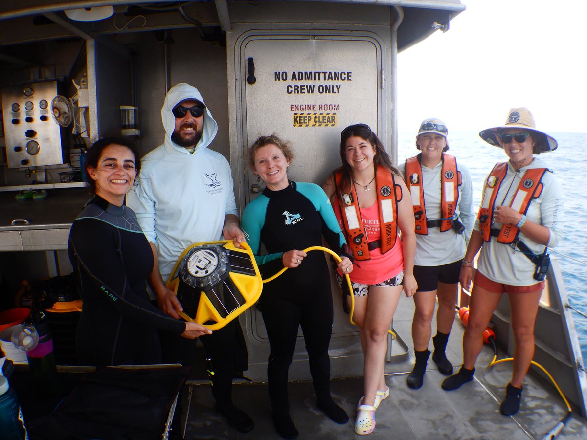
ALT Sanctuary staff wearing dive gear or life vests hold the yellow SoFar buoy and cable as they stand on the deck of R/V MANTA.
1
3
284

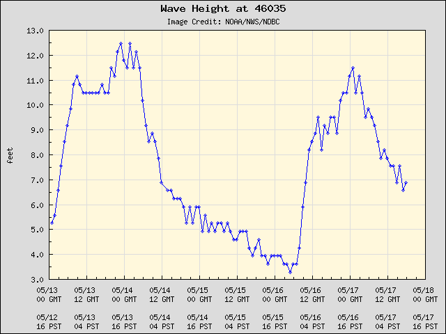
17 May 2023
🌊🌊🌊 Up in the #BeringSea our buoys have been rocking with some waves! Station 46035 (310 nm N of Adak, AK) saw nearly 12 ft waves yesterday afternoon. #waveheight #weatherdata
2
345

2 Mar 2023
Waves can be greatly influenced by tidal currents. Here's how the Scripps Institution of Oceanography reached a correlation between wave height and tide cycles.
#tides #waves #waveheight #surfforecast #surfscience #surf #surfing
1
2
149

19 Feb 2023
Learning the spatiotemporal relationship between wind & significant wave height using #deeplearning
Said Obakrim et al
→ doi.org/10.1017/eds.2022.35
#ConvolutionalNeuralNetworks #LongShortTermMemory #SignificantWaveHeight #WindFields #WaveHeight #Waves #OveanWaves #Wind #WindData
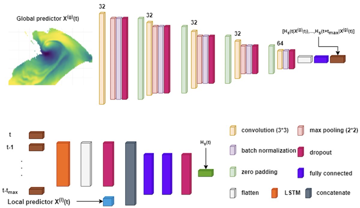
ALT Figure 2. Architecture of the two-stage model in equation (5).
1
6
12
1,906


10 Dec 2022
Fake. Video is compressed sideways to exaggerate waveheight. The ship is NZ Navy HMNZ Otago and the original video is here. Still impressive and no need to fake it.
youtube.com/watch?v=ebrP1Ifi…
5
8
273

20 Oct 2022
Rough seas, as seen from the webcam at buoy 44027 20NM SE of Jonesport. The current waveheight is 8 ft with a SW wind 19 kts gusting to 23 kts. A small craft advisory remains in effect through tonight. ndbc.noaa.gov/station_page.p… #MEwx

ALT Webcam shot from buoy 44027 showing rough seas
5


28 Jun 2022
Looking for data on #Oceans and changing coastlines? The @FishOceansCAN Coastal Infrastructure Vulnerability Index helps small craft harbour sites adapt to the effects of #ClimateChange.
ow.ly/Kr3l50JJI0F
#WaveHeight #WaveSpeed #WaterSafety
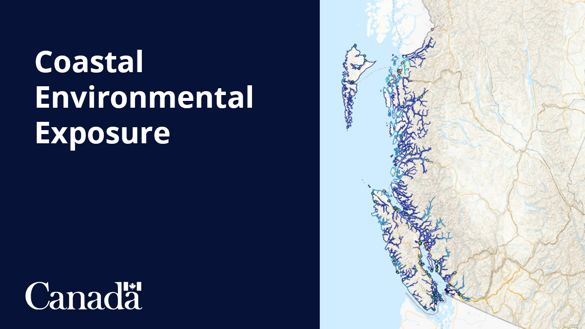
ALT Map of Canada's west coast with a dataset on Coastal Environmental Exposure overlaid
1
3
3