Two journalists @betsymason & @dosmonos who love maps and the stories behind them. Co-authors of the @NatGeo book All Over the Map: A Cartographic Odyssey.
It's here! Our new book "All Over the Map" goes on sale today. If you like maps, history, science, art, design, or just like good stories, you'll love the book! It has 80 stories & more than 200 beautiful maps, some you've never seen before. Check it out! bit.ly/alloverthemap
Lovely map by @landgeist shows us the share of households across Europe that have at least one dog. The biggest dog divide I can see runs between Austria and Czechia.
A Green (& yellowish) Cheese Moon, floating in a deep purple sky! Courtesy of the Army Map Service, Corps of Engineers, 1963. #maps#HarvardLibrary
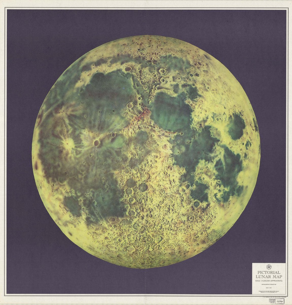
ALT Image of a "Pictorial Lunar Map" (title in lower right corner of the sheet), using an orthographic projection at 1:5,000,000 (approximate), showing the near side of the moon (that due to "tidal locking," always faces the Earth) with green "seas" and yellow craters .
Size comparison of Valles Marineris on Mars and North America, using scaled globes. Blender/QGIS. Land mask created from NaturalEarthData, Mars MOLA DEM from NASA
ALT Comparing the size of Valles Marineris, a large canyon on Mars, and North America. An Earth globe has cutouts of the land masses, and Mars is shown just beneath the surface. The canyon crosses from California in the west to the US/Canada border in the east.
This World Braille Day we got our hands on some of the braille books in our collection. Because it takes more pages than a regular book to convey the content, many braille books are split into several volumes. Learn more: bit.ly/32YtEQe
š·:bit.ly/3FTj0Jm
When the K12 education team at the Map Center teaches World Maps Over Time, students look for evidence of the cartographers' points of view and intended audiences. Who do you think these maps were intended for and what might we guess about Richard Edes Harrison, the cartographer?
Northwest Ranges Make Rare Appearance: Clear skies between storm systems gave satellites a cloud-free view from the Coast Mountains in British Columbia to the Rockies in western Alberta.
earthobservatory.nasa.gov/imā¦#VIIRS#Landsat
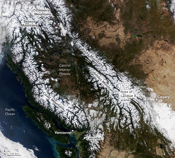
ALT The Visible Infrared Imaging Radiometer Suite (VIIRS) on the NOAA-20 satellite acquired this image during the widespread āunusually pleasantā weather on October 31, 2021. Snowcapped peaks are visible across numerous ranges and subranges, from the Coast Mountains in British Columbia to the Rockies in western Alberta.
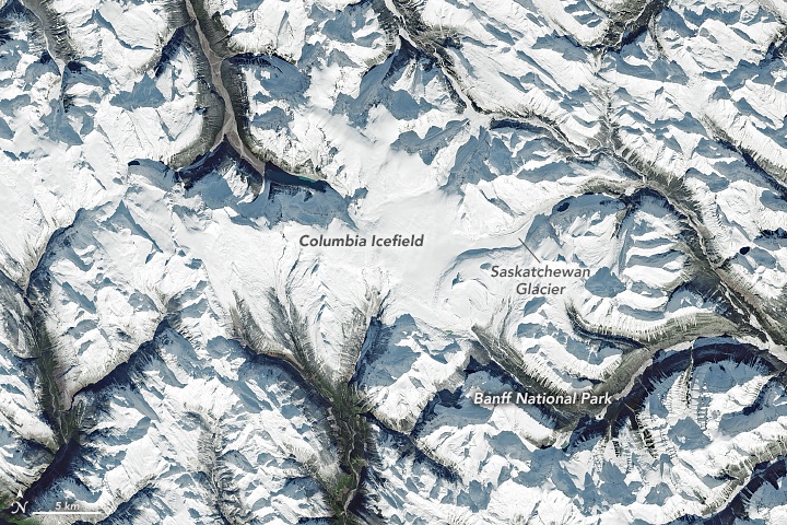
ALT The icefield is visible in this image, acquired on October 31, 2021, by the Operational Land Imager (OLI) on Landsat 8. The icefield spans the provinces of British Columbia and Alberta, as well as Jasper and Banff National Parks. Saskatchewan Glacier, the icefieldās largest outlet glacier, forms the headwaters of the North Saskatchewan Riverāan important source of freshwater for communities downstream.
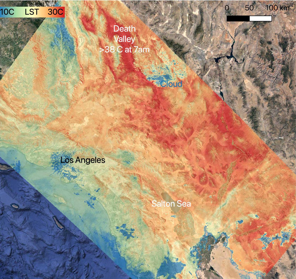
Our latest blog post discusses the fascinating dispute over borders and the mapping of #NewMexico and #Arizona during the American Civil War!
Read all about it here: go.usa.gov/xMxWB
Mount Etna, Europe's tallest and most active volcano, has erupted so much in the past six months that itās grown about 100 feet in height, @SPACEdotcom reports:
bit.ly/3zdqjIF
Want to help make USGS maps more accessible? @MeganSever4 is looking for someone to help edit, proofread and evaluate readability of maps for color-blindness.
Meanwhile, ECOSTRESS -- an instrument attached to the @Space_Station -- captured ground surface temperatures in California. By 7 a.m. local time, some areas reached 86 degrees Fahrenheit (30 degrees Celsius), while Death Valley surpassed that.
ALT On July 8, 2021, NASAās ECOSTRESS instrument, aboard the space station captured ground surface temperature data over California. Areas in red ā including Death Valley ā had surpassed 86 degrees Fahrenheit by 7:16 a.m. local time, well above average ground surface temperatures for the area.
Image Credit: NASA/JPL-Caltech
Do you like maps and data viz? Check out @infowetrust's new series of gorgeous books on Information Visionaries like Florence Nightingale & Emma Willard. New graphics you've never seen, new discoveries, untold stories. Did I mention the books are gorgeous? bit.ly/3boBe8f