
7,231 Photos and videos
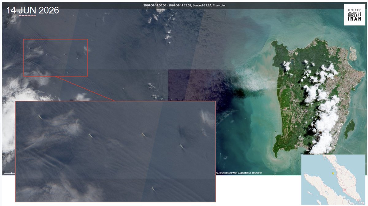


14 JUN 2026
@CopernicusEU #Sentinel2 🛰️📷
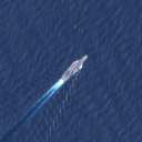
Northern Malacca Strait, ~40km offshore from Penang, Malaysia 🇲🇾
Five 🇮🇷-flagged, OFAC sanctioned Tankers sit at anchor, with no AIS, in the busy sea lanes of Southeast Asia,
These ships have been loitering since the US blockade has stopped nearly 100% of 🇮🇷🛢️bound for Teapot Refineries in 🇨🇳
--
See the @UANI Iran War Shipping Updates for more info:
unitedagainstnucleariran.com…
--
@JemimaShelley @TankerTrackers @mercoglianos @DzirhanDefence @ChongJaIan @amerhadiazmi @AsiriFernandoLK @brentdsadler @MarcusHand1 @OwenWalker0 @YorukIsik

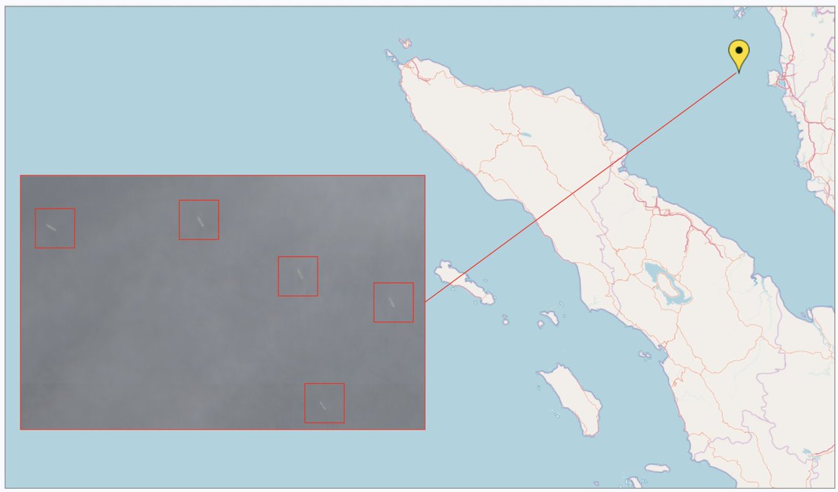
@UANI Iran War Shipping Update – June 12, 2026
unitedagainstnucleariran.com…
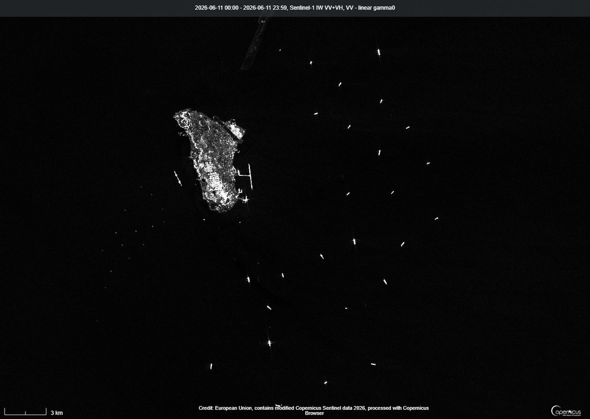
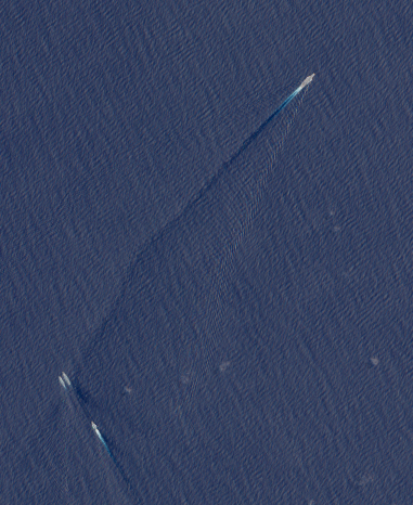
Five unladen 🇮🇷-flagged tankers were spotted in international waters in the Malacca Strait west of Penang, 🇲🇾Malaysia, on 9 JUN.
DERYA (IMO 9569700) was last observed on AIS on 24 MAY in the northern part of the Malacca Strait.
SALINA (IMO 9357377),
SERENA (IMO 9569645),
HUMANITY (IMO 9180281), and
DUNE (IMO 9569712)
were last observed on AIS on 31 MAY also in the Malacca Strait, near One Fathom Bank off Port Klang, at the end of the Traffic Separation Scheme.
@JemimaShelley @TankerTrackers @mercoglianos @ed_fin @CollinSLKoh
@marcushand1
@DzirhanDefence
2
4
342
Charlie B retweeted

🚨BASHI BREAKOUT: On June 7, a 🇨🇳Chinese maritime task force pushed past the Bashi Channel and into the open Pacific.
None were warships. They were coast guard, maritime safety and rescue vessels. The kinds of ships Beijing uses when it wants its presence read as an assertion of lawful jurisdiction over its neighbors' waters.
Hours later, the #CCP-run @globaltimesnews called the operation "a sovereignty declaration with both legal significance and political signaling."
They did not bury the lede. We shouldn't either.
The target was not 🇹🇼#Taiwan alone. It was a maritime delimitation negotiation between 🇯🇵#Japan and the 🇵🇭#Philippines, two 🇺🇸US treaty allies trying to settle their overlapping maritime claims under the 1982 🇺🇳UN Convention on the Law of the Sea, in waters Beijing's own maps don't even claim.
Beijing decided the talks were "completely illegal and void," then ran a multi-agency paramilitary operation to make the point. Coast guard cutters. Provincial Maritime Safety Administration ships. A specialized ocean rescue vessel.
All white-hulled. None of them warships. By design.
Then Beijing had its own state media label the operation a sovereignty declaration, accused the peaceful negotiators of provocation, then cited that label as justification for its own escalation.
This is how China's #grayzone strategy actually works. Not aircraft carriers, not destroyers. A paramilitary force flying civilian colors, advancing a law-enforcement vocabulary, in which patrols like this one first become routine, then become the basis for sovereignty claims the world is expected to accept.
#America's 2026 National Defense Strategy commits to "a strong denial defense along the #FirstIslandChain." The first real test of that doctrine has not come from PLA Navy warships. It has come from white-hulled civilian ships flying a law-enforcement banner, in waters belonging to America's allies.
Allied doctrine needs to grow up.
The First Island Chain has been breached, not by a gray-hulled navy fleet but by white hulls and a vocabulary.
The question now is whether Washington, Tokyo, Taipei and Manila treat this as one more isolated incident to manage, or as the paramilitary challenge to a free and open Indo-Pacific that it actually is.
🔗 Link in the reply below.

5
27
55
3,442
RT @YorukIsik: Russia’s grain smuggling from occupied Ukraine continues by Russian ships sailing in the Black Sea switching off devices tha…
35
Charlie B retweeted

MOFA strongly condemns the brazen & unprecedented intrusion of PRC gov't vessels into waters around Taiping Island. These unlawful actions violate Taiwan's sovereignty, undermine regional peace & challenge the int'l order. We'll continue to staunchly safeguard maritime security.
254
176
665
45,280
13 JUN 2026
@CopernicusEU #Sentinel2 🛰️📷
Just another day in the Singapore Strait
Rare clear day over the busy chokepoint. 😎
Easy to see why Singapore is a #MaritimeNation.
@mercoglianos @CollinSLKoh @BDHerzinger

1
3
21
1,024

Even when a vessel spoofs its GPS position, some AIS data can still be useful. A ship's heading (the direction it's pointing) may remain accurate, which helps to identify and track vessels along with satellite imagery and other sources.
Charlie Brown @supbrow via @bellingcat
bellingcat.com/news/2026/06/…
2
9
27
2,876
Charlie B retweeted

Jun 13
EUNAVFOR ASPIDES recommendations for seafarers are available on the Maritime Security Center Indian Ocean (MSCIO) webpage (mscio.eu/folder/documents/MS…).
The requests for support can preferably be sent to postmaster@mscio.eu (24/7) or made on the website (reporting.mscio.eu/supportre…).
2
7
17
1,182
Charlie B retweeted

Jun 12
Ask most policymakers in Southeast Asia about the impact of a Taiwan crisis & the response is the equivalent of sticking their fingers in their ears and shouting "I can't hear you". But this report from @IISS_org shows the likely consequences for Malaysia
iiss.org/research-paper/2026…
5
17
48
4,213
Charlie B retweeted

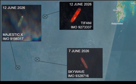
Seems about right if you also take into account the dark transfers of various crude oil and refined products from the Arab nations. Yesterday, we tagged ten large sets of STS transfers in the GoO following their dark, US-escorted passages via the SoH. Iranian crude still remains trapped within the greater US blockade perimeter even if loadings take place every now and then at Iran’s five key crude terminals.
Jun 12

(Reuters) - Roughly 7 million barrels a day of oil are getting out of the Persian Gulf with U.S. military help, Energy Secretary Chris Wright said on Friday at an event in Houston.
27
95
380
114,781
Charlie B retweeted

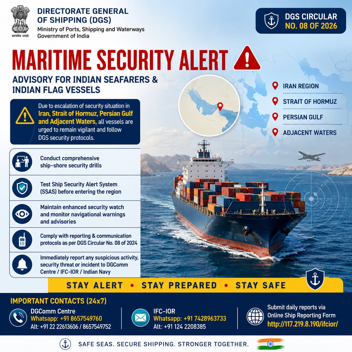
🔴 MARITIME SECURITY ALERT
⚠️ DGS Advisory for Indian Seafarers & Indian Flag Vessels
📍 Iran Region
📍 Strait of Hormuz
📍 Persian Gulf
📍 Adjacent Waters
✅ Conduct Security Drills
✅ Test SSAS Before Transit
✅ Maintain Enhanced Security Watch
✅ Report Suspicious Activities Immediately
Stay Alert • Stay Prepared • Stay Safe
Issued by:
Directorate General of Shipping (DGS), India @dgshipping_IN
3
5
13
1,109
Charlie B retweeted
Jun 12
The only reason that China claims the James Shoal - an underwater feature off the coast of Borneo - as the 'southernmost point of Chinese territory' is because of a translation mistake in 1935 and some bad map-making. Let's all laugh at China in sticking with this idiocy...
Jun 11

The Silent Takeover: How China is Quietly Rewriting the Borders Off Sarawak’s Coast
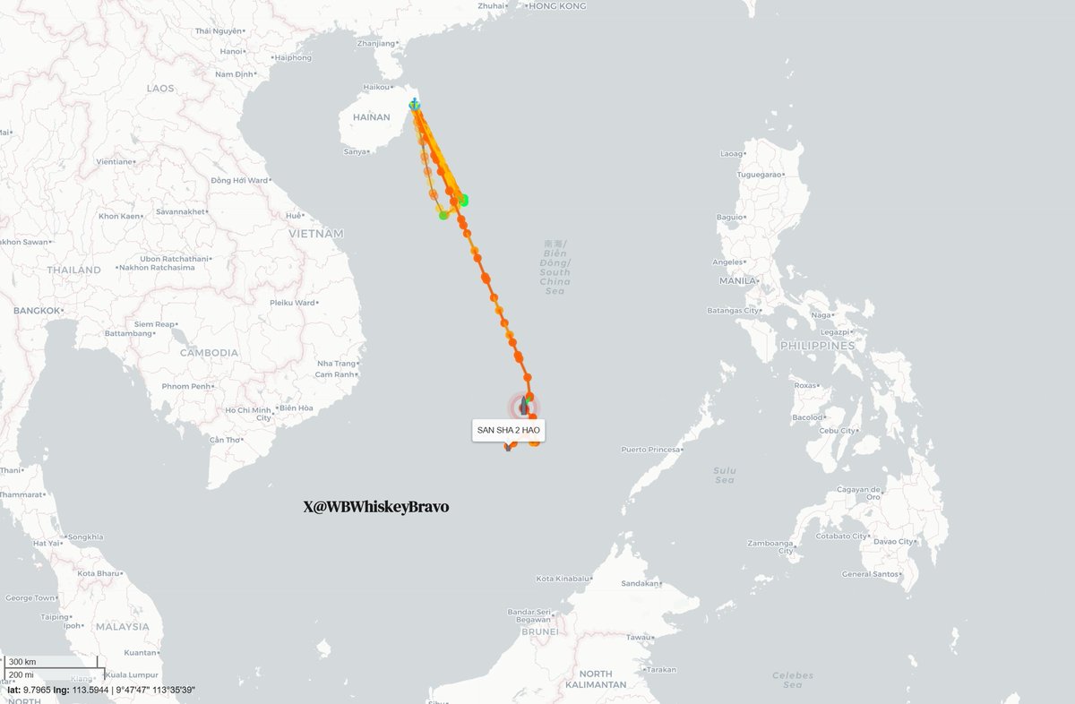
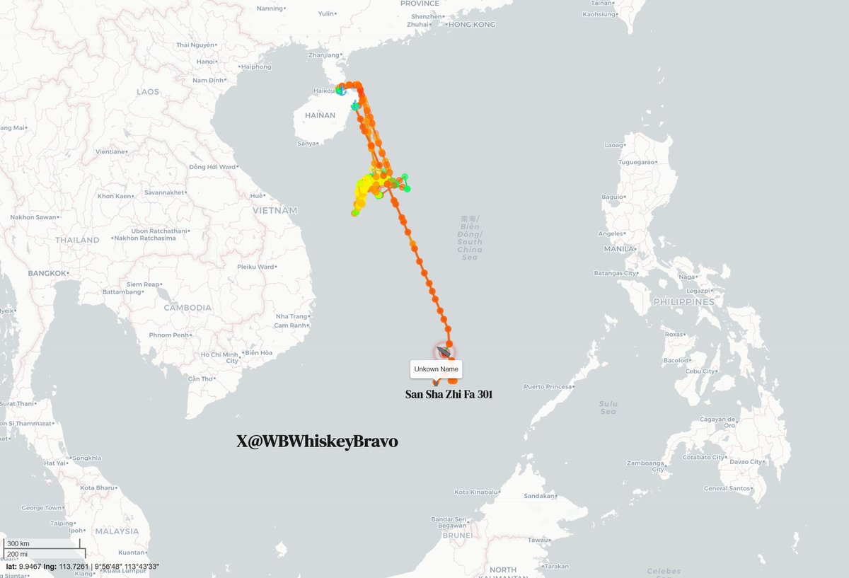
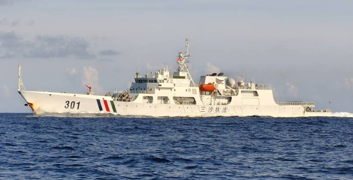
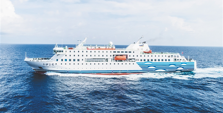
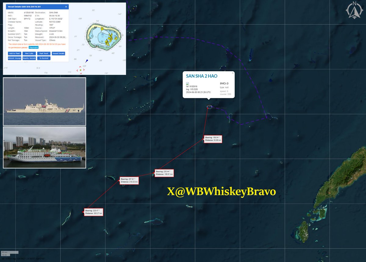
While most of us go about our daily lives, a quiet but deeply troubling game of chess is playing out just off the coast of Sarawak, where fresh ship-tracking data reveals that China’s massive 8,000-ton supply ship, the Sansha 2 Hao, along with its armed escort cutter, the San Sha Zhi Fa 301, has packed up and left Hainan. This fleet is steaming directly south toward Beting Serupai (James Shoal / Seahorse Breakers), a completely submerged reef sitting just 45 nautical miles—about 80 kilometers—northwest of Bintulu, placing it squarely in Sarawak’s backyard. This voyage fits perfectly into Beijing's broader grey-zone tactics, which are designed to aggressively change realities on the water while staying just below the threshold of open military conflict. To enforce its sweeping nine-dash line without triggering an international military outcry, China masterfully relies on "white hull"—coast guard and municipal vessels—instead of navy warships, allowing them to bully local maritime zones under the guise of routine domestic and administrative patrols.
The reason Chinese delegates and municipal fleets execute this voyage on a strict, annual basis comes down to a calculated symbolic ritual designed to manufacture legal and historical "evidence" of ownership. Because Beijing historically and geographically defines Beting Serupai (Zengmu Ansha) as the absolute southernmost point of Chinese national territory, it holds massive nationalistic and political significance. Since the feature is completely submerged about 22 meters underwater, China cannot build an artificial military island on it; instead, they send annual delegations on these white hulls to conduct "sovereignty ceremonies" above the reef. In past rituals, Chinese naval personnel and officials have literally dropped sovereignty steles (stone markers) into the water and stood on the decks to swear collective oaths of allegiance to defend the motherland's outer limits. By sending the Sansha city fleet down every single year, Beijing is attempting to satisfy the international legal criteria of "continuous and effective administration." They are intentionally creating an annual paper trail that falsely claims a local Chinese city has been successfully governing a piece of the seabed just 80 kilometers from Bintulu.
This annual municipal voyage is just the crowning piece of a massive, multi-tiered machinery that builds upon the homework done by older research ships like the Nan Feng and Zhong Shan Da Xue, which originally gathered resource intelligence in the Malaysian Maritime Zone (MMZ). Today, that legacy is carried forward by modern high-tech spies like the XIANG YANG HONG 33, YUE ZHAN YU ZHI 20026, and 20027, which were caught on satellite imagery on June 6 tightly bunched together at Terumbu Laya (Dallas Reef), updating underwater maps under the protective shield of armed white hulls like CCG 5302, 5403, 5309, and 5901. By dropping the Sansha municipal fleet directly alongside this ongoing scientific and military grid, Beijing is essentially using the annual trip to lock down East Malaysia’s richest economic zones, posing a direct threat to Sarawak’s multi-billion dollar offshore oil and gas fields. Yet, while neighbors like the Philippines push back through "assertive transparency" by openly exposing these incursions, Putrajaya has stuck to its strict playbook of "quiet diplomacy," preferring behind-the-scenes talks to avoid public friction. This heavy silence risks being misread by Beijing as "tacit acquiescence," giving them a path of least resistance to slowly turn a fictional map into a permanent reality. Furthermore, because national security is tightly controlled by the federal government, this quiet approach leaves the local Sarawak state leadership dangerously in the dark about a creeping grey-zone threat operating just a stone's throw away from its vital economic lifelines and maritime sovereignty.
9
33
64
9,148
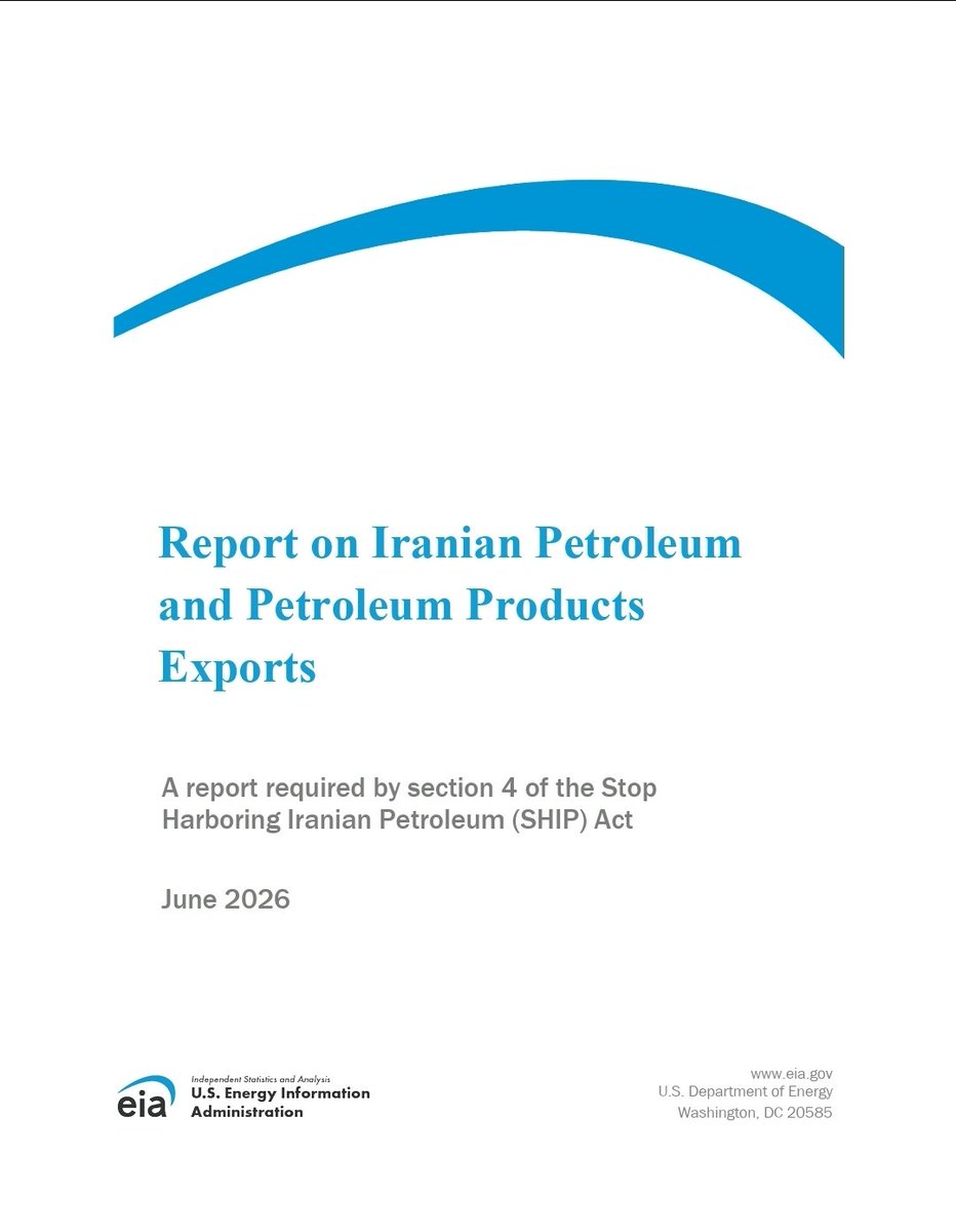
🚨Hot off the press!
@EIAgov
Report on Iranian Petroleum
and Petroleum Products
Exports
A report required by the "SHIP Act"
June 2026
My Friday night reading.
eia.gov/international/analys…
@JemimaShelley @TankerTrackers @mercoglianos @ed_fin
5
7
1,563
Charlie B retweeted

Jun 11
The Silent Takeover: How China is Quietly Rewriting the Borders Off Sarawak’s Coast
While most of us go about our daily lives, a quiet but deeply troubling game of chess is playing out just off the coast of Sarawak, where fresh ship-tracking data reveals that China’s massive 8,000-ton supply ship, the Sansha 2 Hao, along with its armed escort cutter, the San Sha Zhi Fa 301, has packed up and left Hainan. This fleet is steaming directly south toward Beting Serupai (James Shoal / Seahorse Breakers), a completely submerged reef sitting just 45 nautical miles—about 80 kilometers—northwest of Bintulu, placing it squarely in Sarawak’s backyard. This voyage fits perfectly into Beijing's broader grey-zone tactics, which are designed to aggressively change realities on the water while staying just below the threshold of open military conflict. To enforce its sweeping nine-dash line without triggering an international military outcry, China masterfully relies on "white hull"—coast guard and municipal vessels—instead of navy warships, allowing them to bully local maritime zones under the guise of routine domestic and administrative patrols.
The reason Chinese delegates and municipal fleets execute this voyage on a strict, annual basis comes down to a calculated symbolic ritual designed to manufacture legal and historical "evidence" of ownership. Because Beijing historically and geographically defines Beting Serupai (Zengmu Ansha) as the absolute southernmost point of Chinese national territory, it holds massive nationalistic and political significance. Since the feature is completely submerged about 22 meters underwater, China cannot build an artificial military island on it; instead, they send annual delegations on these white hulls to conduct "sovereignty ceremonies" above the reef. In past rituals, Chinese naval personnel and officials have literally dropped sovereignty steles (stone markers) into the water and stood on the decks to swear collective oaths of allegiance to defend the motherland's outer limits. By sending the Sansha city fleet down every single year, Beijing is attempting to satisfy the international legal criteria of "continuous and effective administration." They are intentionally creating an annual paper trail that falsely claims a local Chinese city has been successfully governing a piece of the seabed just 80 kilometers from Bintulu.
This annual municipal voyage is just the crowning piece of a massive, multi-tiered machinery that builds upon the homework done by older research ships like the Nan Feng and Zhong Shan Da Xue, which originally gathered resource intelligence in the Malaysian Maritime Zone (MMZ). Today, that legacy is carried forward by modern high-tech spies like the XIANG YANG HONG 33, YUE ZHAN YU ZHI 20026, and 20027, which were caught on satellite imagery on June 6 tightly bunched together at Terumbu Laya (Dallas Reef), updating underwater maps under the protective shield of armed white hulls like CCG 5302, 5403, 5309, and 5901. By dropping the Sansha municipal fleet directly alongside this ongoing scientific and military grid, Beijing is essentially using the annual trip to lock down East Malaysia’s richest economic zones, posing a direct threat to Sarawak’s multi-billion dollar offshore oil and gas fields. Yet, while neighbors like the Philippines push back through "assertive transparency" by openly exposing these incursions, Putrajaya has stuck to its strict playbook of "quiet diplomacy," preferring behind-the-scenes talks to avoid public friction. This heavy silence risks being misread by Beijing as "tacit acquiescence," giving them a path of least resistance to slowly turn a fictional map into a permanent reality. Furthermore, because national security is tightly controlled by the federal government, this quiet approach leaves the local Sarawak state leadership dangerously in the dark about a creeping grey-zone threat operating just a stone's throw away from its vital economic lifelines and maritime sovereignty.
30 Jun 2024
Just another year. The PRC conducts an annual event in which high-ranking CCP delegates travel to the southernmost part of their claim. The participant transport was the luxurious passenger ship SAN SHA 2 HUO, escorted by SAN SHA ZHI FA 301, which had just departed Mischief Reef.
8
53
104
18,545
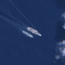
11 JUN 2026
@CopernicusEU #Sentinel1 🛰️RADAR📷
Malaysian Eastern Out of Port Limits (EOPL) anchorage
Some stats:
🚢 245 vessels detected in the EOPL area (red box)
🚢 147 correlated to AIS signal (~60%)
🚢 98 not correlated, ie dark (~40%)
🚢~35 ships are falsely flagged
🚢~15 have an unknown flag
🚢~50 are sanctioned by a national authority
--
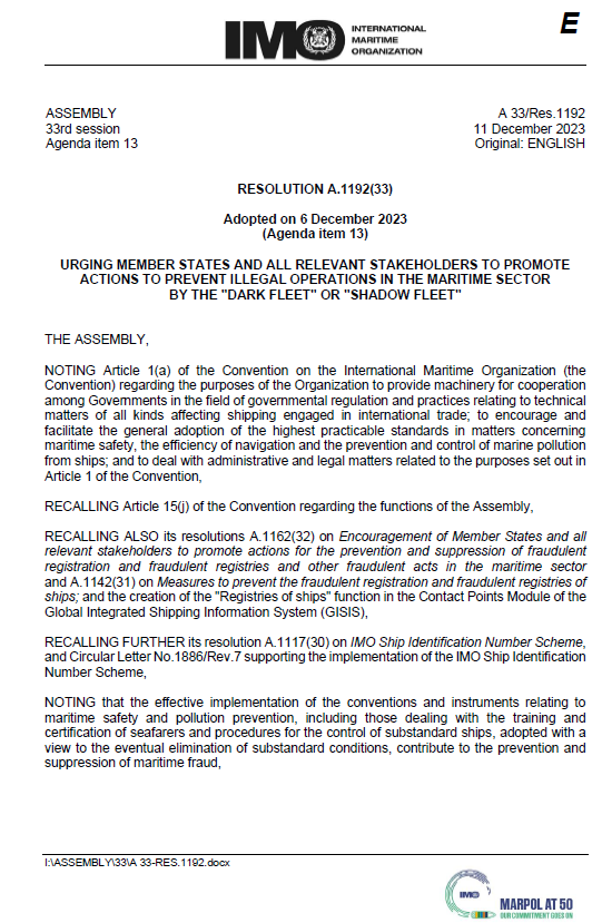
@IMOHQ Assembly Resolution 1192 (33) of 2023:
NOTING WITH CONCERN information about those ships engaging in illegal operations for the purposes of circumventing sanctions or engaging in other illegal activities and referred to for the purposes of this resolution as the "dark fleet" or "shadow fleet",
NOTING WITH CONCERN ALSO information that these ships intentionally disable or manipulate their shipborne automatic identification systems (AIS),... and have substandard maintenance, unclear ownership, lack of insurance coverage and disguise their cargoes' destination or origin,
CALLS UPON coastal States to monitor STS operations in their territorial sea and exclusive economic zone, ... and take appropriate actions in cases identified as not complying with the maritime safety and prevention of marine pollution regulations;
ENCOURAGES coastal States to collaborate to improve monitoring of these practices and operations;
--
See more info at @UANI Iran War Shipping Update:
unitedagainstnucleariran.com…
--
@JemimaShelley @TankerTrackers @mercoglianos @DzirhanDefence @CollinSLKoh @MarcusHand1
1
6
16
998
11 JUN 2026
@CopernicusEU #Sentinel2 🛰️📷
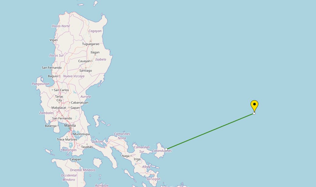
15.1487, 127.6607
In the Philippine Sea, ~370km offshore of Catanduanes Island, Philippines
Likely the 🇨🇳#Liaoning #CV16
Performing Underway Replenishment
--
@d_viekass
@MT_Anderson
@tom_bike
@songs349
@PLATracker
@detresfa_
@AaronMatthew_L
@SeaLightFound
@GordianKnotRay
@CollinSLKoh
@songs349
@TaiwanMonitor
Late observation:
28 MAY 2026
@CopernicusEU
#Sentinel2 🛰️📷
19.1656, 123.7150 in the Philippine Sea, ~170km offshore form Philippines
Likely the 🇨🇳PLA Navy Aircraft Carrier #Liaoning #CV16
@d_viekass @MT_Anderson
@tom_bike @songs349 @PLATracker @detresfa_ @AaronMatthew_L @SeaLightFound @GordianKnotRay @CollinSLKoh @songs349 @TaiwanMonitor
15
40
17,869
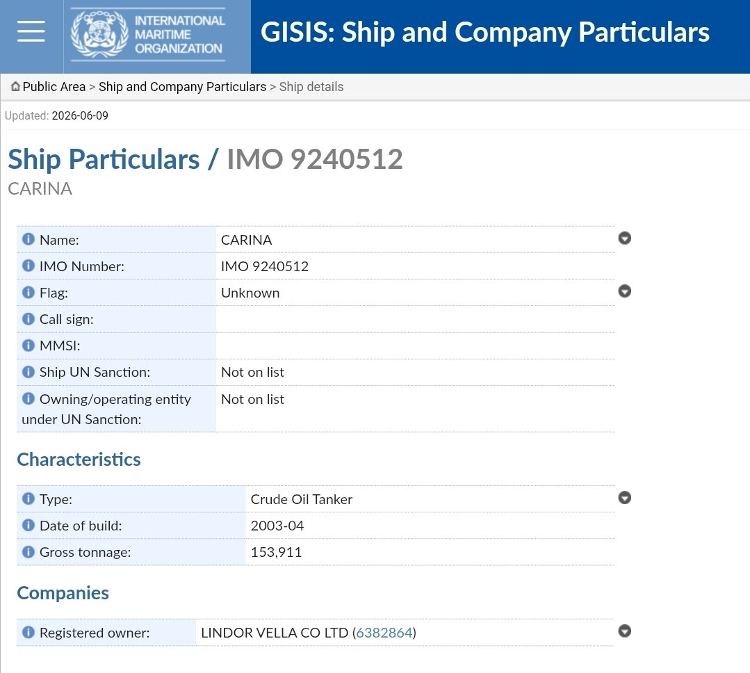
FYI, #USSCanberra:
The @UANI blacklisted #GhostArmada tanker CARINA (IMO 9240512), is sitting right now off Colombo 🇱🇰, in the anchorage. It is a stateless vessel with an unknown flag according to the @IMOHQ, and links to Iran 🇮🇷🛢️
Also, there's four 🇮🇷-flagged tankers anchored off Galle, 🇱🇰, as well.
Might want to keep tabs on those ships.
--
More info in the @UANI Iran War Shipping Update:
unitedagainstnucleariran.com…
--
@JemimaShelley
@mercoglianos
@TankerTrackers
@ed_fin
@AsiriFernandoLK
@nilanthis
Jun 12

The Independence-variant of the @USNavy littoral combat ship #USSCanberra (LCS 30) called at #ColomboPort for a brief replenishment stop. Canberra is the fourth USN LCS to call at Colombo thus far.
#SriLanka #Navaldiplomacy #IOR

9
12
1,697
11 JUN 2026
@CopernicusEU #Sentinel1 🛰️RADAR📷
🇮🇷 Kharg Island anchorage
~24 vessels (likely tankers) in the anchorage.
That's 24 tankers NOT sailing to the 🇲🇾 Malaysian Eastern Out of Port Limits (EOPL) anchorage with 🇮🇷🛢️ bound for 🇨🇳Teapot Refineries.
This is due to the US Blockade on Iranian ports.
--
More info at @UANI Iran War Shipping Update:
unitedagainstnucleariran.com…
--
@JemimaShelley @mercoglianos @TankerTrackers @ed_fin @brentdsadler
7
19
1,977

Trump claimed a secret U.S. operation helped 200 commercial ships transit the Strait of Hormuz.
Now a June 5 INTERTANKO advisory reviewed by gCaptain describes a U.S.-coordinated nighttime route along the Omani coast involving ships operating with AIS off, navigational lights extinguished, and limited radar use.
The advisory not only corroborates with Trump's claims, but also offers the clearest description yet of how limited shipping has continued through Hormuz during the conflict.
Full story: gcaptain.com/tanker-industry…
8
103
442
186,484
Charlie B retweeted

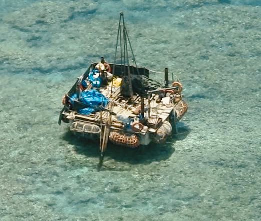
Jun 12
Beijing accuses us of “hyping.” Let us be precise about what actually happened. We observed a structure inside Bajo de Masinloc. We documented it, dated it, geolocated it, and released the aerial imagery to the public. That is not hype — that is transparency. And transparency is only threatening to the party that has something to hide.
To “hype” something is to exaggerate or invent it. We did neither. The imagery speaks for itself, and we put it in front of the Filipino people, the region, and the international community precisely so that no one has to take our word for it — or Beijing’s. The fact that China’s instinct is to attack the reporting rather than explain the structure tells you everything. What is irresponsible is not a coast guard doing its job and informing the public. What is irresponsible is the unilateral placement of structures in another country’s exclusive economic zone, in open defiance of the 2016 Arbitral Award — and then calling the act of documenting it a provocation.
And there is a reason we cannot simply accept Beijing’s description of these as “normal activities.” We have heard this before. When the People’s Republic of China first occupied Mischief Reef in 1995, it assured the world that the structures it was putting up were nothing more than shelters for its fishermen. Today, Mischief Reef is a fully militarized artificial island — runway, hangars, radar, missile capabilities — sitting squarely inside the Philippines’ exclusive economic zone. The “fishermen’s shelter” was the cover story.
So when China waves away the structure at Bajo de Masinloc as “normal,” it is asking the region to forget its own record. That is precisely why these actions cannot be taken at face value.
If China genuinely wants to be believed, there is a simple way to show it: pull out. Remove the platform, halt the installation of buoys/communication towers, and respect the 2016 Arbitral Award and waters that are legally ours. Anything less only confirms the pattern — that China’s assurances at Bajo de Masinloc today are worth exactly what its word at Mischief Reef proved to be three decades ago.
The choice belongs to Beijing. It can preserve what little good faith the region and the international community still extend to it, or it can keep proving why that trust was misplaced to begin with.
134
600
2,155
552,235