
Geospatial • Messed up with @qgis
Joined December 2012
- Tweets 365
- Following 724
- Followers 97
- Likes 1,191
52 Photos and videos


Lerry W. 🗺️ retweeted

30 Jul 2024
Exciting news! Remastered Natural Earth v6 raster data are now available. You will find the map files here: shadedrelief.com/ne-draft/
4
56
291
16,056

Introducing our new Mapbox Standard style, with 3D urban environments, dynamic lighting, landmark 3D buildings, and an elegant symbolic aesthetic.
📣 Learn more in our announcement post: buff.ly/3DPC9MI
#mapdesign #mapping #gischat
9
28
111
40,314
Lerry W. 🗺️ retweeted

7 Aug 2023
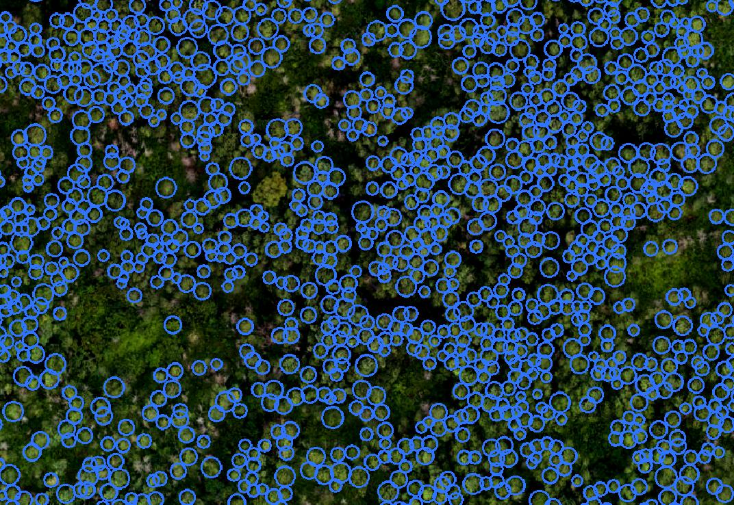
Segment-geospatial v0.9.0 is out📢It now supports segmenting remote sensing imagery with box prompts. You can create box prompts interactively or use existing vector data as box prompts 🌐
GitHub: github.com/opengeos/segment-…
Notebook: samgeo.gishub.org/examples/b…
Video tutorial: youtu.be/ayFgAj23BfI
#geospatial #segmentanything #deeplearning
1
63
287
24,192
Lerry W. 🗺️ retweeted

11 Jul 2023
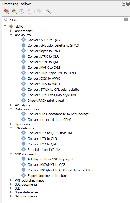
Here is a new blog post about SLYR - The Esri to QGIS Compatibility Suite – QGIS Plugin
developed by @northroadgeo septima.dk/nyheder/SLYR-plug…
#esri #qgis
41
142
11,005
Lerry W. 🗺️ retweeted

10 Jul 2023
🌍🛰️ The DEM4S2 portal is now open! Access it at visioterra.org/DEM4S2/
DEM4S2 provides a Digital Elevation Model (DEM) for orthorectifying #Sentinel2 L2A products. Retrieve DEMs that perfectly align with your Sentinel-2 data, same extent, CRS, and GSD.
🧵1/2

3
54
241
15,254
Lerry W. 🗺️ retweeted

12 Jun 2023
Paul Ramsey (@pwramsey): Holy Sheet! Remote Access CSV Files from Postgres postgr.es/p/5LW
2
24
101
15,473

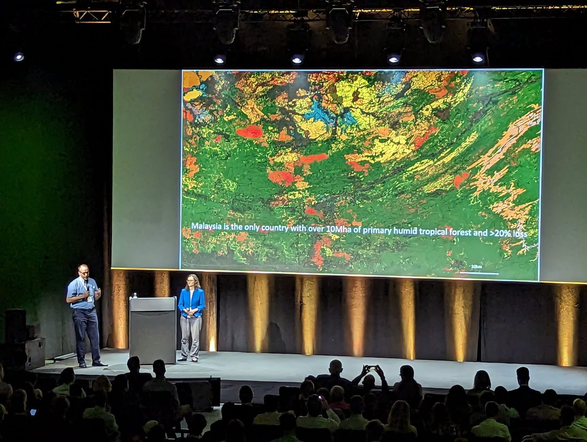
Professor Matthew Hansen of @UMD_GLAD presenting at the opening plenary session of the @landcarbonlab Summit in Brussels. Watch the recording: summit2023.landcarbonlab.org
5
20
1,751

Now available free and #opensource!
Cesium for Omniverse enables #3D #geospatial capability for @NVIDIAOmniverse. Build and operate industrial #metaverse applications with real-world 3D content. bit.ly/3Lz9y3x
1
12
31
2,904
Lerry W. 🗺️ retweeted

2 Mar 2023
How to create a modular city with Blender and geometry nodes. This process is easy-to-use and light-weight as it relies on instances. Full video on youtube.com/uhstudio
#blender #blenderarchitecture #design #geometrynodes #blender3d #geonodes #modulardesign #architecturedesi
7
88
521
36,117
Lerry W. 🗺️ retweeted

1 Mar 2023
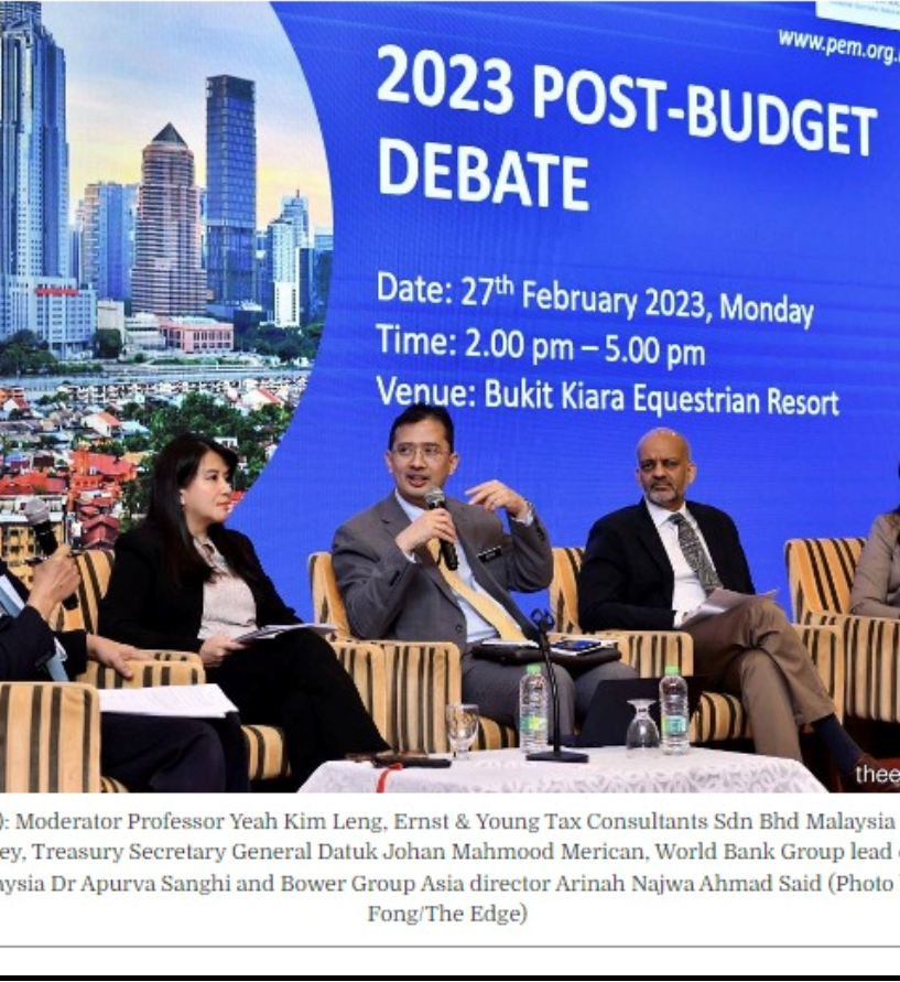
How does Malaysia’s 2023 Budget fare?
My views, through the 3D lens of:
D-ata
D-evelopment
D-iscipline
PS: this is a condensed version of my remarks at the wonderfully organized Post-Budget Debate by the esteemed Malaysian Economic Association (#MEA).
3
55
146
26,971
Have you tried Cesium for #Unity? The free #opensource plugin combines the #3D #geospatial capabilities of Cesium and #3DTiles with the Unity ecosystem: bit.ly/3XCTyAj
8
28
3,725
Lerry W. 🗺️ retweeted

3 Feb 2023
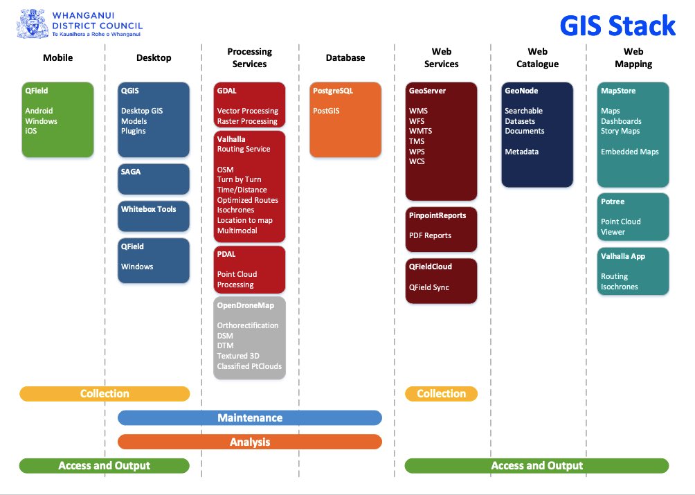
You: "I could never run a GIS shop without Esri"
Whanganui Council: "Hold my beer."
data.whanganui.govt.nz/docum…
14
199
920
110,789
Lerry W. 🗺️ retweeted

29 Jan 2023
Daily #Blender Tip: Creating a toon shader with complete control over the colors is easy with just a couple of nodes. #B3D Free Blender Secrets Sample PDF (which quite possibly has a discount for the book in it):
buff.ly/3wexKiP
6
251
2,120
164,326
Lerry W. 🗺️ retweeted

28 Jan 2023
I’ve worked both at a company creating radar satellite images & ones using sat images to solve specific problems
I’ve interviewed some of the most thoughtful people working on SAR
I think SAR is one of the most promising satellite image tech but has an education problem
Thread:
17
94
607
223,348
Lerry W. 🗺️ retweeted

25 Jan 2023
TorchGeo is a PyTorch library that provides datasets, samplers, transforms, and pre-trained models specific to geospatial data!🛰️
If that sounds interesting to you, we've just released v0.4 with tons of new stuff! Check out the release notes here: github.com/microsoft/torchge…
6
50
314
27,921

26 Jan 2023
Aerial mapping flight planner with follow terrain capabilities. Easy to use with mobile flight planner that support KML. #python #pyqgis #aerialmapping #drone #photogrammetry #remotesensing #earthscience
117
Lerry W. 🗺️ retweeted

20 Jan 2023
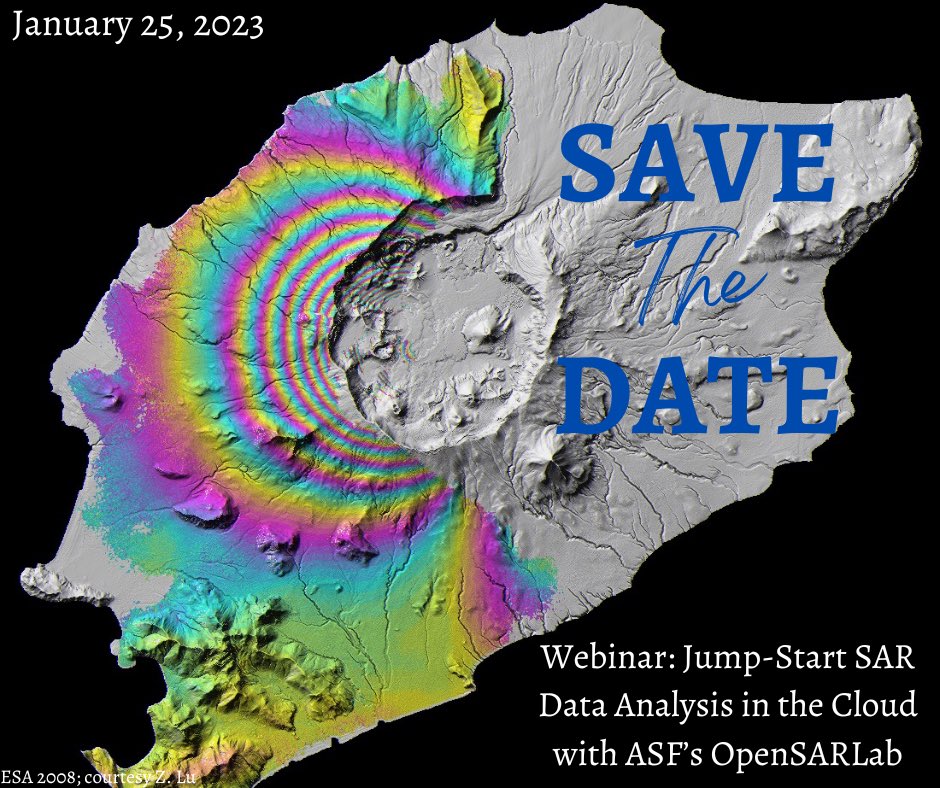
🔗 earthdata.nasa.gov/learn/web…
#GoldenAgeofSAR #ASF #NASAEarthdata #openscience #education #Cloud #DataScience #BigData #Jupyter
@SARevangelist @EricFielding @aJollyAdventure
1
30
57
4,594
Lerry W. 🗺️ retweeted

18 Jan 2023
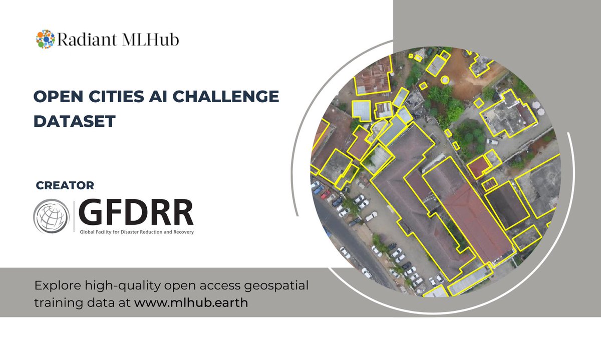
🌍 #EarthData - Building footprints
📍 Cameroon, Congo, Ghana, Seychelles, Tanzania, Uganda
🔑Access this #ML-ready geospatial training data
mlhub.earth/data/open_cities…
Created by @GFDRR
2
16
66
4,597