
🚀 NEW on We ❤️ Open Source 🚀
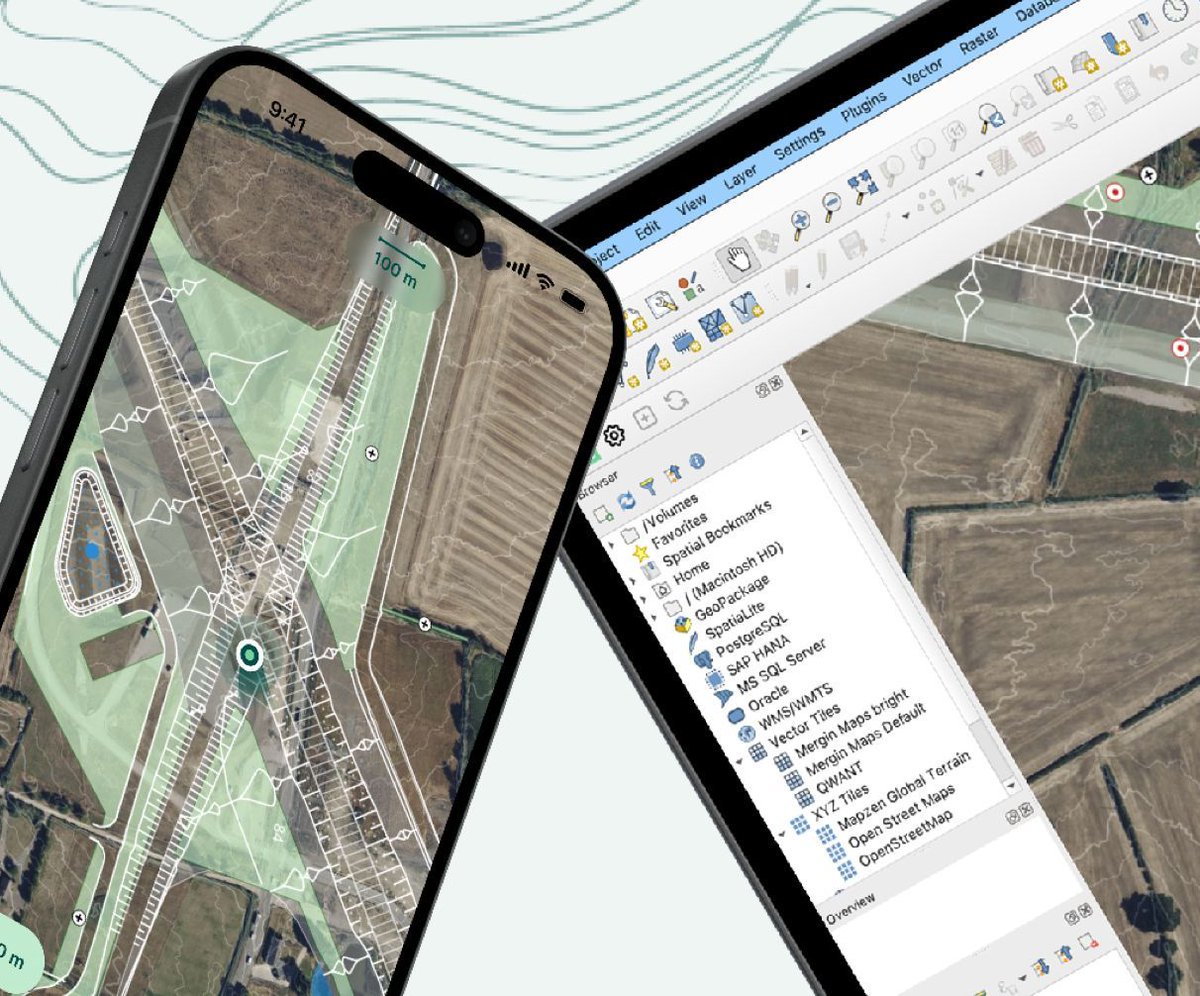
Want to turn QGIS into a mobile field mapping tool? Don Watkins shows how to connect QGIS with MerginMaps to collect and sync geospatial data from your phone while you’re out in the field.
Read: allthingsopen.org/articles/q…
#WeLoveOpenSource #QGIS

ALT Left side says We Love Open Source. #WeLoveOpenSource. ATO. A community education resource from All Things Open. Right side has mobile phone on top of a map of the world.
4
156

1 Dec 2025
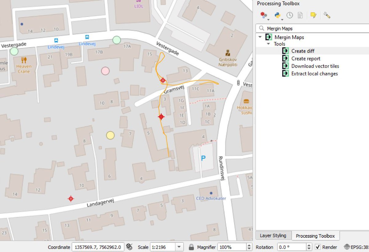
Mergin Maps: Collect, Share, and Publish GIS Field Data
Mergin Maps is a powerful mobile GIS solution that lets you record geospatial field data on your smartphone or tablet and instantly synchronize it with QGIS. Say goodbye to paper field notes, manual georeferencing, and lost GPS coordinates — Mergin Maps makes field data collection fast, accurate, and collaborative.
Core Capabilities:
📍 Capture geodata easily — points, lines, areas, photos, and QR/barcode scanning
📊 Instant visualization — view your data and location on the map while in the field
🔄 Seamless synchronization — sync projects with QGIS desktop or other field users with a single click
☁️ Cloud-based storage & versioning — automatically track changes and merge edits from multiple surveyors
⚙️ QGIS integration — compatible with your existing QGIS projects and fully supports all analysis and map production tools
Applications / What You Can Do:
🔹 Agriculture — sample soil and harvest data for food quality monitoring
🔹 Water utility — record pressure readings or leak locations
🔹 Forestry — track forest health and planting operations
🔹 Construction & Engineering — monitor construction progress and keep digital records
🔹 Environmental Protection — digitize inspections and field observations
🔹 Local Government — inspect properties and enhance public safety
🔹 Telecommunications & Transportation — track teams, assets, and field infrastructure
🔹 Natural Resources — capture geological surveys and drilling logs
Use Mergin Maps to take your QGIS projects into the field, sync changes instantly, and make sure your team always works with the latest spatial data.
👷Ready to go from beginner to professional and job-ready in GIS? We’ve created a complete blueprint to guide you step-by-step through QGIS, taking you from your first map to advanced, real-world GIS projects: whop.com/orion-terrametrics/…
😉Follow Godwin Murithi for more GIS tools & tech
#MerginMaps #GIS #QGIS #FieldDataCollection #RemoteSensing

1
11
55
2,380

24 Sep 2025
Webinaire @MerginMaps
Collecte de données terrain avec Mergin Maps: Cas d'utilisation
Inscrivez-vous ici : bit.ly/4pGNSEg
#Mapping #DataCollect #data #Transporte #Opendata

2
3
49

12 Sep 2025
6
650
26 Aug 2025
🌍 [PARTENARIAT ] @DataTransport1 & @MerginMaps unissent leurs forces pour les SIG open-source en #Afrique Francophone ! 💡 Formations, conseil, et adoption locale de #QGIS & #MerginMaps.
data-transport.org/officiali…
#Opensource #Mapping #GIS #Geospatial
#Transport #Mobility


3
4
224

13 Aug 2025
Akhirnya, setelah dua hari kurang tidur, berhasil juga instal Custom MerginMaps di server.

2
7
416

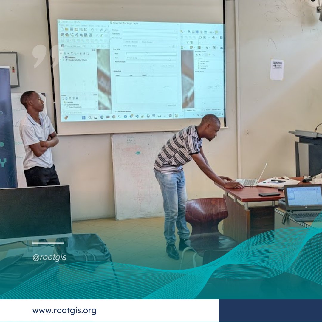
Confidence is rising, and the project is leveling up!
Our students are confidently navigating the full data pipeline
🔹 Designing smart forms using @qgis and @MerginMaps
🔹 Data cleaning and analyzing maps
🔹 Enhancing field data with street-level imagery via @mapillary
4
75
Now in week 2, Our Students dive deep in the mobile data collection using @MerginMaps and @qgis. Creation of interactive forms, sever configurations, setting our website UIs, and display rules.
Follow us for more!


4
122
2 May 2025
7
33
1,399

12 Mar 2025
Read up on everything you need to know to harness the power of Mergin Maps – our concise book Collecting Field Data with QGIS and Mergin Maps is ideal for beginners and pros alike. Get it here: locatepress.com/book/mergin-…
#merginmaps #QGIS #geospatial
2
141
27 Jan 2025
Take a deep dive into Mergin Maps with our book, Collecting Field Data with QGIS and Mergin Maps – learn to set up advanced projects, configure survey layers, conduct field surveys, create maps, and more. Get it here: buff.ly/3MEuTrA #qgis #merginmaps #geospatial

2
7
317
30 Dec 2024
Our most recent book, Collecting Field Data with QGIS and Mergin Maps, has everything you need to harness the power of QGIS and the Mergin Maps platform. This book walks you through how to set up a project, configure survey layers, conduct a field survey, create maps, and more. Get it here: buff.ly/3MEuTrA #qgis #merginmaps #geospatial
2
10
887

I made a new video for the @MerginMaps YouTube channel. Snapping in #QGIS and Mergin Maps. youtu.be/aFG0iDuZZuI

1
3
378
27 Nov 2024
If you're looking for an approachable guide to Mergin Maps and QGIS, we've got you! Our book, Collecting Field Data with QGIS and Mergin Maps, has everything from project setup to field surveys to advanced workflows. Get it here: buff.ly/3MEuTrA
#QGIS #merginmaps #fieldsurvey
1
4
317

🎉 Welcome our new Bronze Sponsors! 🌍 @ArkEdgeSpace , @MerginMaps , QField Cloud by @OPENGISch & @mapbiomas support geospatial innovation & sustainability. 🌱💡
#foss4g2024 #sponsors #gischat #opensource


1
9
448

15 Nov 2024
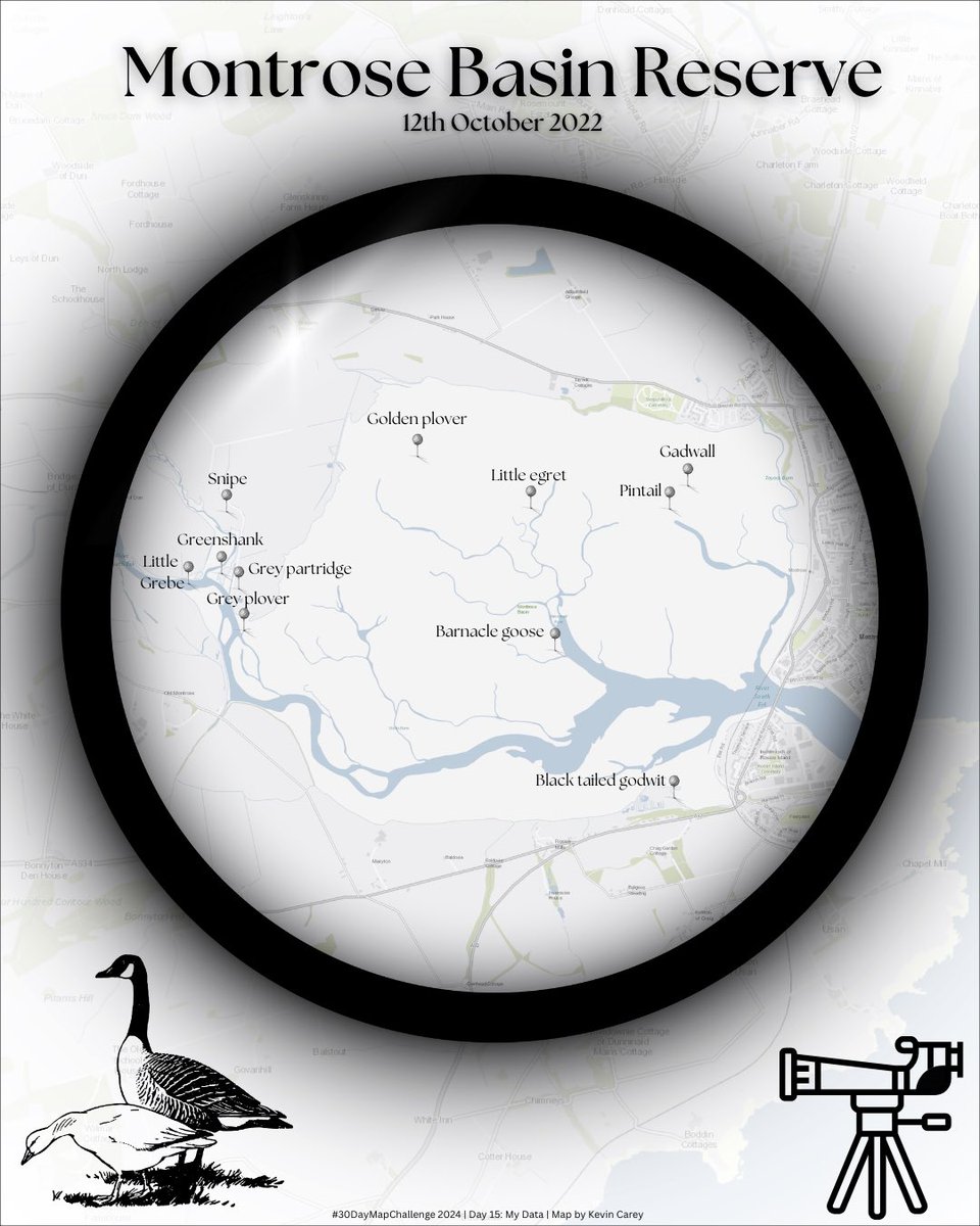
Day 15: My data
Data collected with @MerginMaps at Montrose Basin
#30DayMapChallenge #Canva#RSPB
3
201
11 Nov 2024
The final chapter of our newest book on QGIS and Mergin Maps walks you through 4 tasks to teach you the basics of map composition with your QGIS field data. By the end of the chapter, you'll be an expert in using the Categorical renderer, configuring SVG symbols, composing print layouts, and more. Get it here: buff.ly/3MEuTrA
#QGIS #merginmaps #fielddata #mapcomposition
6
273

28 Oct 2024
You wished for measurement tools and we listened! Introducing the most requested feature for Mergin Maps! Check out our blog to learn more:
merginmaps.com/blog/mergin-m…
#QGIS #fieldsurvey #newfeature #measurementtools #MerginMaps
1
5
400
22 Oct 2024
Our latest book on QGIS and Mergin Maps, gives a detailed walk through of how to properly conduct a field survey, touching on position tracking, navigation, processing algorithms, synching back to QGIS, and more. Get your copy here: buff.ly/3MEuTrA
#QGIS #merginmaps #fieldsurvey
1
8
441
16 Oct 2024
SMASH: app libre para toma de datos en campo rviv.ly/Zw51eX #dispositivosmóviles #MerginMaps #QField
1
23
64
2,331