
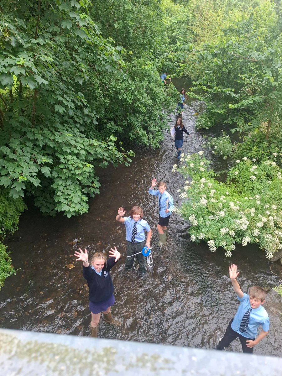
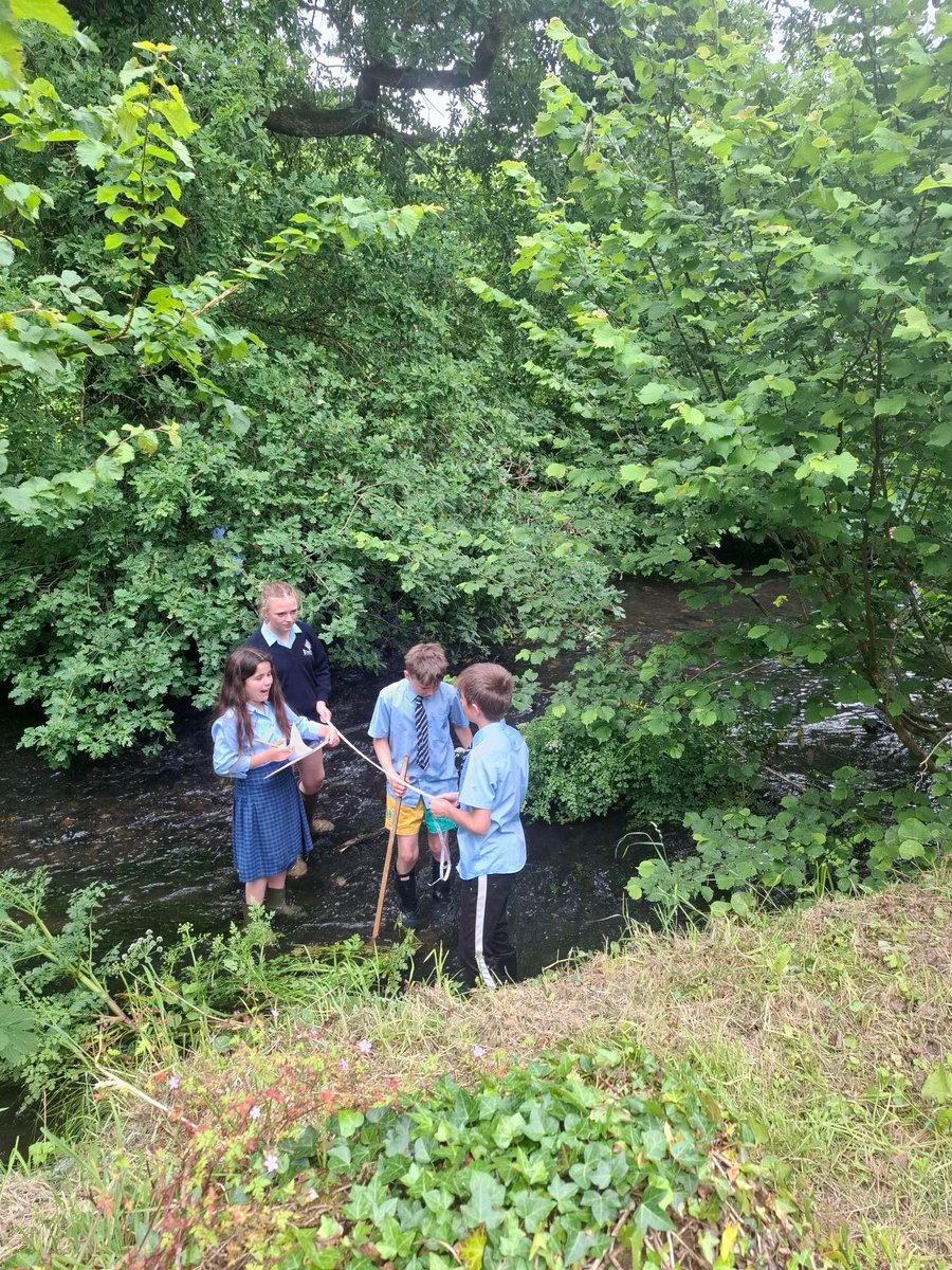
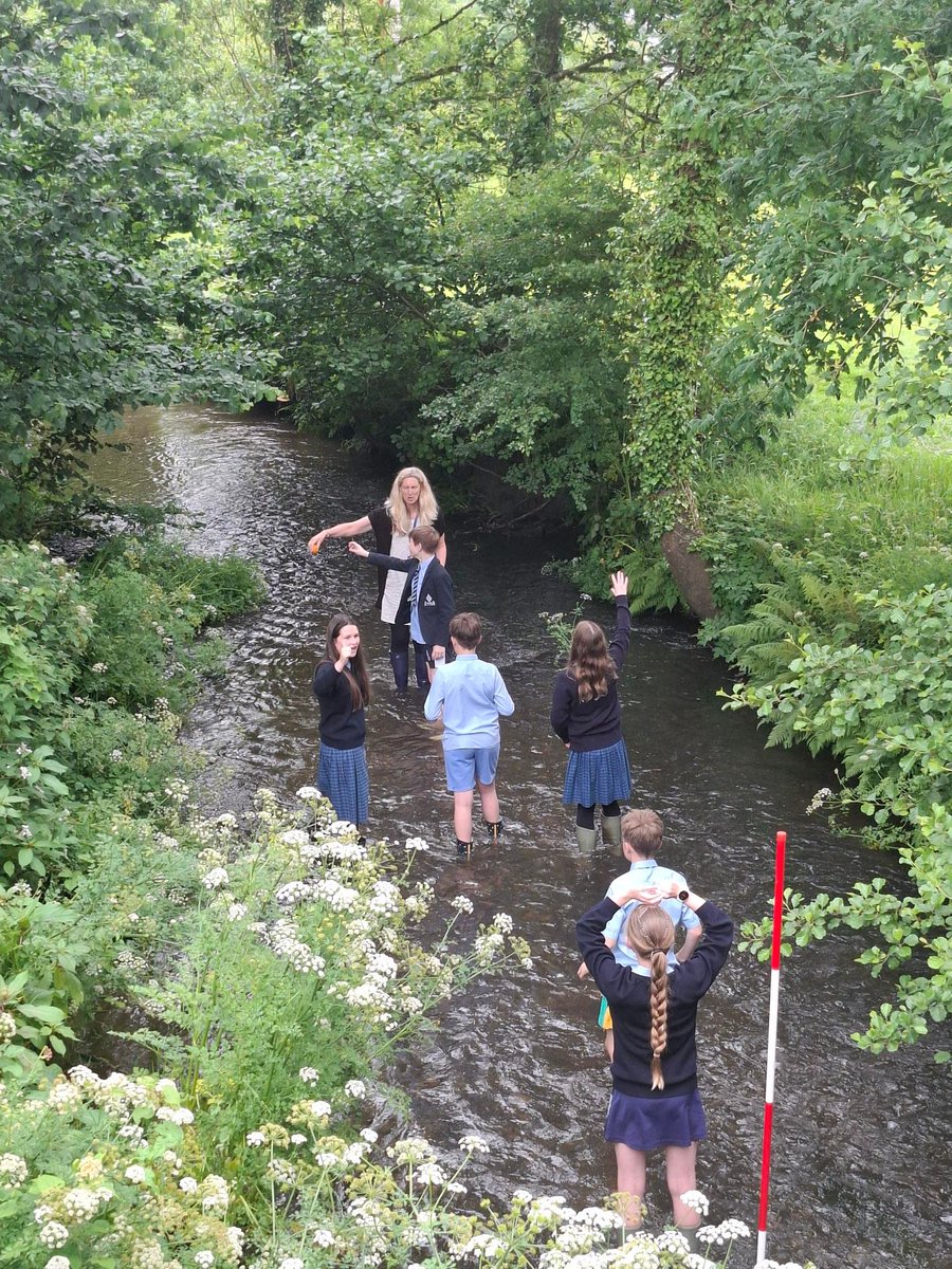
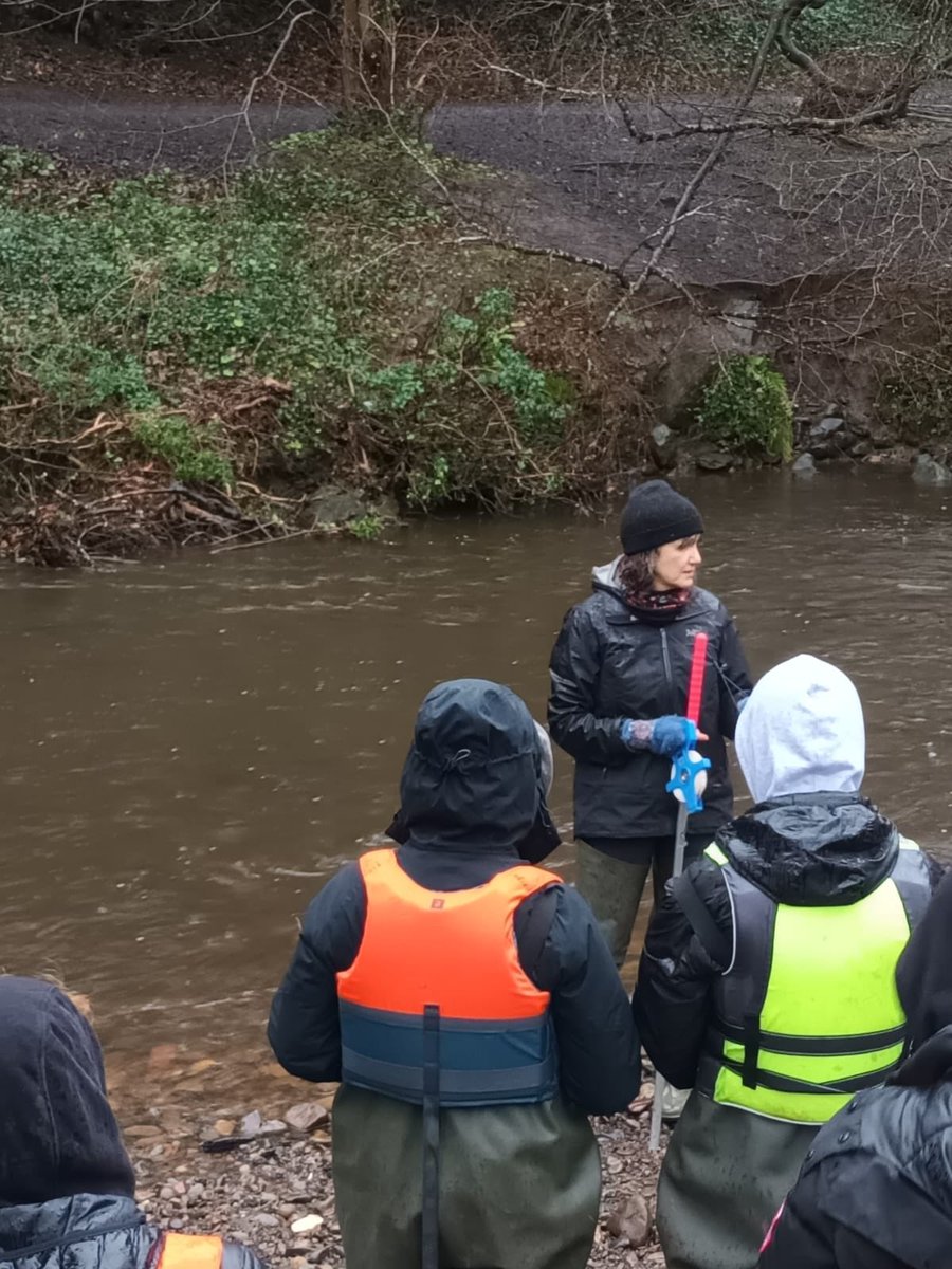
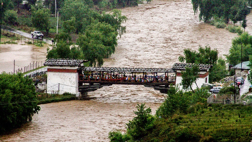
Year 7 geographers undertook their first fieldwork investigation on the River Kensey. They measured the river’s width, depth and velocity, observed landforms and examined its bedload—a fantastic opportunity to apply classroom learning in a real-world environment.
12

Jun 13
From first to last verse
it’s prattled and pursed,
an endless bargain bin flutter of fascinators –
words to erode riverbeds
fashioned from basalt ballast
she’s a bedload of corrasion
for every occasion.


1
10

May 27
A genuinely good intellectual use of AI is to ask it about concepts I would otherwise have trouble finding via google. I learned the term "bedload transport" this way for instance.
10
790

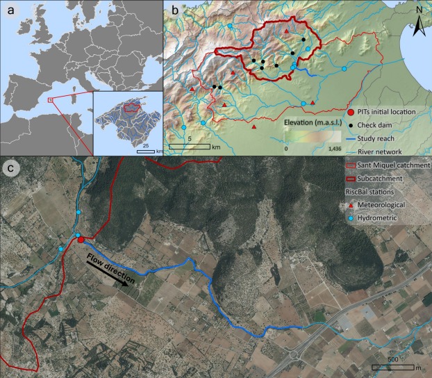
@RiscBal new paper: Flood events drive bedload & suspended sediment, with similar grain-size mobility and strong seasonality-key for understanding flood hazards and erosion risk in Mediterranean regions. #IRES #FEDER @FBiodiversidad @FondosUE_Esp @AgEInves authors.elsevier.com/sd/arti…

5
4
459

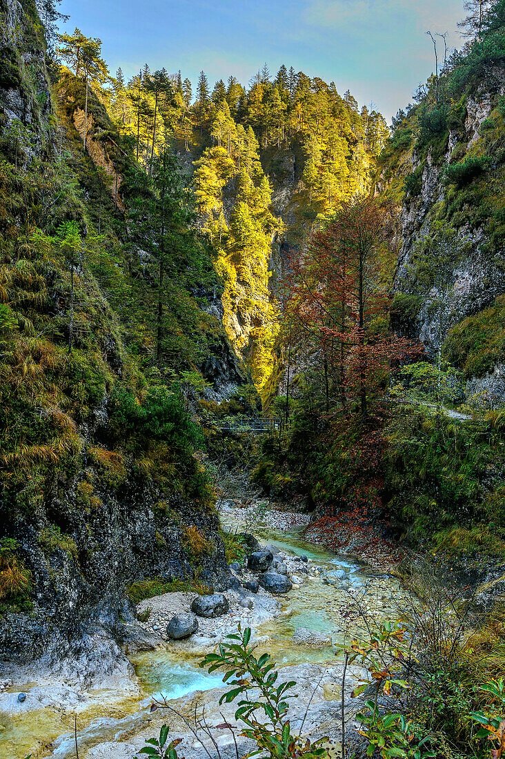
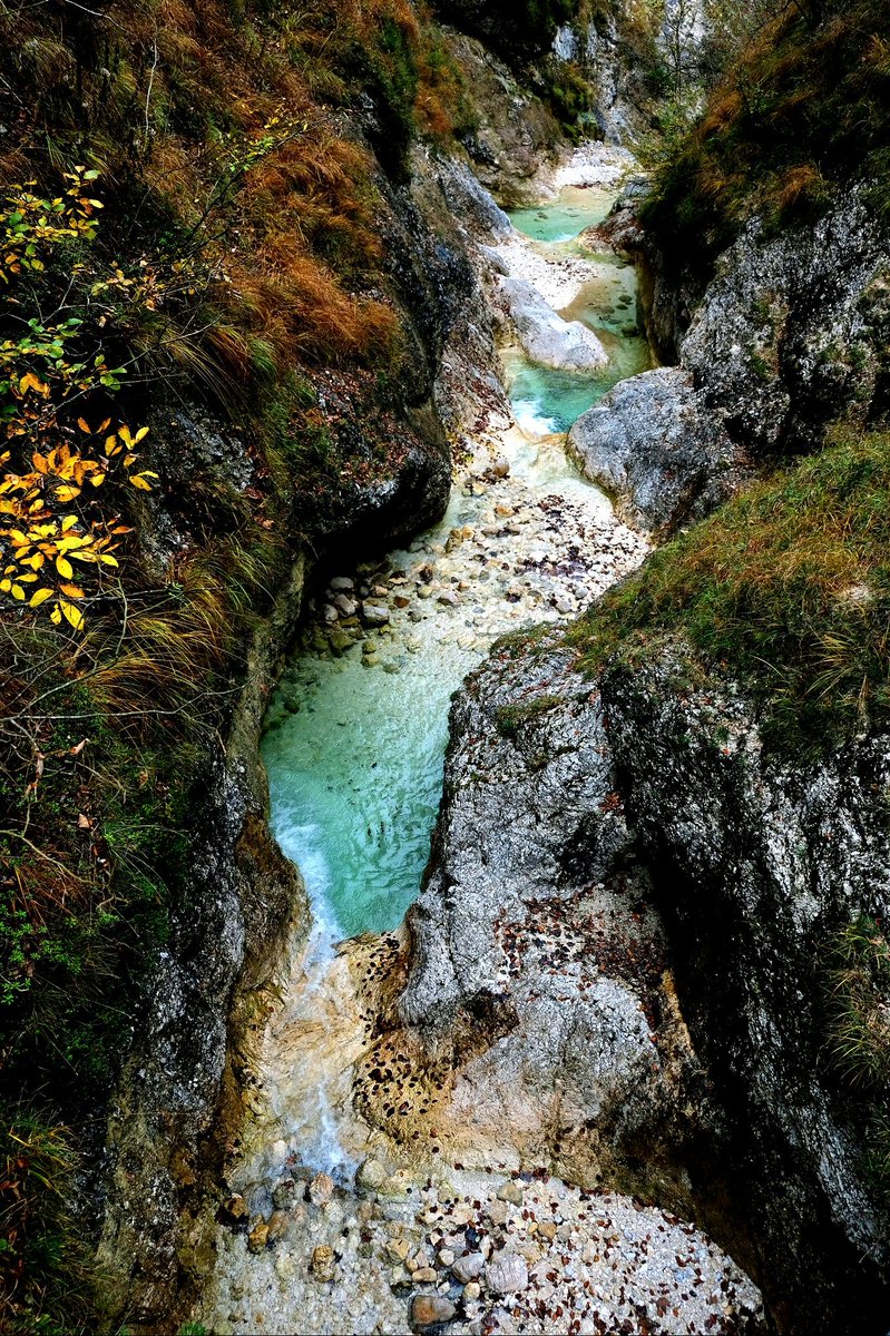
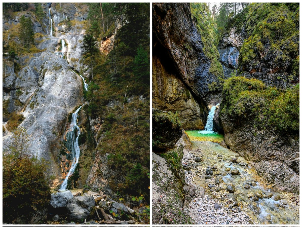
🟥 ⛏️ The geology of Almbachklamm gorge, Bavaria; dramatic alpine gorges do not need massive glaciers to carve them, Almbachklamm shows how a modest mountain stream can sculpt a deep, narrow slot canyon.
🔁 ❤️ - Greatly Appreciated
Almost entirely through post-glacial fluvial erosion!
Almbachklamm is a spectacular ~3 km-long gorge carved by the Almbach stream into Triassic limestone and dolomite of the Northern Limestone Alps.
The stream exploits fractures and joints in the brittle carbonate rocks, eroding vertically via hydraulic action, abrasion by bedload, and dissolution chemistry (CO₂-rich rainwater forming weak carbonic acid that dissolves CaCO₃).
This creates sheer walls, waterfalls, plunge pools, and smooth-polished sections.
Experts identify the formation style by the gorge's narrow V- to slot-shape in soluble limestone, contrasting with broader U-shapes from glacial scour, plus abundant solution features like scallops and potholes along the channel.
The host rocks formed ~200–230 million years ago in the Triassic from Tethys Ocean sediments, but the gorge incision accelerated after the Last Glacial Maximum (~20,000–10,000 years ago) when retreating glaciers left steep gradients and abundant meltwater; ongoing erosion continues today.
It's found in the Schellenberger Forst near Marktschellenberg, just outside Berchtesgaden National Park, Berchtesgaden Alps, southeastern Bavaria, Germany, close to the Austrian border.
This reveals how fluvial processes dominate post-glacial landscape evolution in limestone terrains, outpacing glacial carving in many alpine valleys, shifting our understanding of gorge formation timing and mechanisms, emphasizing rapid incision rates in karst-influenced settings and the role of chemical weathering alongside mechanical erosion.
#hashtag
#Almbachklamm
nationalpark-berchtesgaden.d…
1
4
74

Comment: Bedload transport in Himalayan rivers has been overlooked, hindering the development of models to predict responses to extreme floods under global warming
nature.com/articles/s41561-0…
1
7
24
2,202

Two days of high school river studies and we’re loving the milder weather, though hands still get pretty chilly collecting bedload samples.


1
7
319

15 Dec 2025
📣 The iNNO SED Project is delighted to share the recently published paper: 'Wing dam effects on water and bed levels in rivers are influenced by bedload type', from Török & Parker, 2025. #riverhydromorphology #DanubeRiver #morphodynamicmodeling
👉tinyurl.com/3jpfd3t9

3
4
44

6 Oct 2025
A unique feature of North Bengal’s hydrography is its integration into several transboundary river basins: the Jaldhaka, Raidak (Wang Chhu), Sankosh, and Torsa all originate in or traverse Bhutan before entering Indian territory.
The physical character of these rivers, steep Himalayan upper catchments, seasonal snowmelt and monsoon-driven flows, narrow gorges transitioning to broad alluvial fans, makes them highly responsive to precipitation variability.
Extensive hydrological monitoring in Bhutan shows a pronounced seasonal pattern in river discharge:
Peak discharge occurs during the monsoon months (June–August), with flows in Bhutanese catchments like Doyagang on Amochu (Amochhu/Toorsa) reaching over 700 cumecs, while lean season flows in winter drop to as little as ~20 cumecs.
Short, high-intensity rainfall events, common to the Himalayan monsoon belt, produce rapid run-off and flood pulses, which can propagate downstream and cause flash floods in North Bengal’s lower river basins.
Sediment transport from Bhutan is also significant: monsoon flows carry high concentrations of suspended and bedload sediment into the Dooars, compounding riverbed aggradation and flood risk.
Most flood events in North Bengal linked to Bhutanese water flow occur during the peak monsoon, when intense rainfall in Bhutan precipitates sharp increases in river discharge that overwhelm downstream channels. This risk is magnified by:
Sudden dam releases (for safety or hydropower management) without adequate downstream warning;
Dam gate failures or operational accidents, as occurred with the Tala Hydropower Dam in October 2025, where a technical malfunction resulted in uncontrolled overflow and downstream flash flood warnings for the Dooars.
Downstream, the confluence of Bhutanese rivers with major Indian (and Sikkimese) rivers like the Teesta, plus contributions from local precipitation, can result in compound flood risk, especially when surges coincide with already saturated floodplains or ongoing high discharges from upstream sources.
Incidents of flooding, erosion, and infrastructure failure have become more frequent in low-lying areas like Alipurduar, Jalpaiguri, and Cooch Behar, with cross-border sediment and water flow from Bhutan identified as key causal factors during specific years.
In spite of having Joint Technical Team (JTT) and Joint Experts Team (JET) on flood forecasting and management, Memoranda of Understanding (MoUs),challenges persist.
Data sharing is sometimes delayed due to communication or technical hurdles, reducing the efficacy of early warning systems in the face of sudden dam releases or extreme rainfall;
Complex operation and multiplicity of dams in Bhutan and Sikkim mean that cumulative effects can be difficult to predict or manage without synchronized hydrological and operational data sharing;
Reported issues of pollution and sediment-laden flows (including dolomite-rich water from mining in Bhutan) have affected agriculture and forests in the Dooars, requiring more comprehensive cross-border environmental management.
In a nutshell, what were once manageable, periodic floods are now chronic, often compounding disasters, as decades of siltation and encroachment combine with extreme hydrological events. The region’s poorest,tribal communities, tea laborers, smallholder farmers face the greatest risks from environmental decline. Human-wildlife conflict, food insecurity, and out-migration are growing, with uncertain futures.
North Bengal stands at a crucial environmental crossroads. With careful policy, science-informed action, and robust cross-border cooperation, the region can move towards a sustainable future, one that honors its natural heritage, supports its people, and builds resilience in the face of a changing climate. Without such integration, the wounds of deforestation, degraded rivers, and unchecked floods may only deepen, threatening the very landscape that makes North Bengal unique.
ALT Courtesy thegef.org
1
9
418

Wing dam effects on water and bed levels in rivers are influenced by bedload type bit.ly/48GEzOj
2
3
159

23 Aug 2025
Did we not know the weight of the rock and compare that to the bedload capacity before making this move? (Not that you needed to know either to know this would not go as planned.)

5
31

9 Jun 2025
"Marine enhanced rock weathering (mERW) boosts ocean CO₂ storage by increasing seawater alkalinity.
Using a model focused on France’s coastal zone, this study estimates mERW could sequester up to 210 Mt CO₂ over 100 years, with bedload sediments offering the highest rates.
Only 23% of territorial seas are suitable after excluding conservation areas. While not sufficient alone, mERW could support broader CDR efforts. Sediment type and dissolution kinetics are key to its effectiveness."

1
3
205

29 May 2025
We are seeking applicants for two funded PhD positions exploring environmental seismology, turbulent flow hydraulics and bedload transport using smartrocks. One student will be based at New Mexico Tech and one at UT Austin. Student start dates could be Fall 2025 (NMT), Spring 2026 (NMT), or Fall 2026 (UT).
Coarse sediment transport in river systems is a fundamental control on rates and patterns of erosion, deposition, and channel migration. It influences flood hazards, river management, communities, and infrastructure near rivers. Yet quantifying when, where, and how much bedload moves during floods remains challenging, as direct measurements are usually limited in scope, require expensive in-channel monitoring infrastructure, and can be dangerous. Our project involves a series of controlled laboratory experiments, conducted at a large outdoor flume at the University of Texas at Austin, using paired seismic, Distributed Acoustic Sensing (DAS), and hydroacoustic instruments co-deployed with a suite of turbulent flow and bedload monitoring instrumentation including instrumented smartrocks. The lab experiments will be followed by a field deployment to evaluate the efficacy of best deployment practices developed in the flume.
Students will work with an interdisciplinary team with expertise in seismology, hydrology, fluid dynamics, and fluvial geomorphology. One student will be based at New Mexico Tech to focus on the seismic and DAS data analysis, co-advised by Dr. Susan Bilek (NMT) and Dr. Danica Roth (Univ. Colorado-Boulder). Another student will be based at UT-Austin focused on turbulence and sediment transport data, co-advised by Dr. Joel Johnson (UT), Dr. Blair Johnson (UT) and Dr. Dan Cadol (NMT). Both students will gain experience quantitatively analyzing flow, transport and seismo-acoustic data and will participate in designing the experiments and field campaign.
For more information, please contact Dr. Susan Bilek (susan.bilek@nmt.edu) and/or Dr. Joel Johnson (joelj@jsg.utexas.edu).
2
5
496

29 May 2025
Copied*
We are seeking applicants for two funded PhD positions exploring environmental seismology, turbulent flow hydraulics and bedload transport using smartrocks. One student will be based at New Mexico Tech and one at UT Austin. Student start dates could be Fall 2025 (NMT), Spring 2026 (NMT), or Fall 2026 (UT).
Coarse sediment transport in river systems is a fundamental control on rates and patterns of erosion, deposition, and channel migration. It influences flood hazards, river management, communities, and infrastructure near rivers. Yet quantifying when, where, and how much bedload moves during floods remains challenging, as direct measurements are usually limited in scope, require expensive in-channel monitoring infrastructure, and can be dangerous. Our project involves a series of controlled laboratory experiments, conducted at a large outdoor flume at the University of Texas at Austin, using paired seismic, Distributed Acoustic Sensing (DAS), and hydroacoustic instruments co-deployed with a suite of turbulent flow and bedload monitoring instrumentation including instrumented smartrocks. The lab experiments will be followed by a field deployment to evaluate the efficacy of best deployment practices developed in the flume.
Students will work with an interdisciplinary team with expertise in seismology, hydrology, fluid dynamics, and fluvial geomorphology. One student will be based at New Mexico Tech to focus on the seismic and DAS data analysis, co-advised by Dr. Susan Bilek (NMT) and Dr. Danica Roth (Univ. Colorado-Boulder). Another student will be based at UT-Austin focused on turbulence and sediment transport data, co-advised by Dr. Joel Johnson (UT), Dr. Blair Johnson (UT) and Dr. Dan Cadol (NMT). Both students will gain experience quantitatively analyzing flow, transport and seismo-acoustic data and will participate in designing the experiments and field campaign.
For more information, please contact Dr. Susan Bilek (susan.bilek@nmt.edu) and/or Dr. Joel Johnson (joelj@jsg.utexas.edu).
1
7
24
2,966

28 Apr 2025
⏳ Few days left to apply! PhD on environmental seismology: monitor rivers with seismic networks, detect flash floods & bedload transport, support early warning systems. Fieldwork data analysis real impact! 🌊🌍 Apply here ➡️ geoscienze.unipd.it/phd-admi… #PhD
1
5
280

15 Apr 2025
The hinge function provided “a tractable solution to an important and long standing problem in the field of fluvial geomorphology–the prediction of bedload sediment transport in rivers.” How cool is that?
statmodeling.stat.columbia.e…
2
2,545

11 Apr 2025
[1] Large quantities of sand may be transported throughout the flow column, but the transport of suspended and bedload sediment along the channel depends on flow turbulence and high flow velocities, and coarser sediment remains as bedload.

2
2
51
13 Mar 2025
🌍🔬 PhD in Environmental Seismology! Monitor river activity using seismic data to track flash floods & bedload transport for early warning systems. Based at Univ. of Padova & OGS, Italy.
📢 Apply now! 👉 geoscienze.unipd.it/corsi/ph…
#PhD #Seismo #Rivers #EarlyWarning @GeoUnipd
4
11
506

27 Jan 2025
Dostałem kilka pytań o "równowagę hydrodynamiczną koryta cieku" w kontekście regulacji wód, więc dopowiadam:
1. Przepisy o obowiązku jej zachowania obowiązują w Polsce od 2002 r. (art. 67.3 'starego' Prawa wodnego i art. 236.3 'nowego' PW). Stosowanie tego przepisu leży w kompetencjach @MI_GOV_PL, @GSrodowiska i @WodyPolskie.
2. W kilku krajach UE gospodarkę rumowiskiem rzek próbuje się powiązać z RDW. Kluczową pracą pokazującą stan podejścia w UE jest praca pn. "Integrated sediment management. Guidelines and good practices in the context of the Water Framework Directive" z 2002 r. (circabc.europa.eu/ui/group/9…).
3. Mamy narzędzia cyfrowe wspomagające analizy w tym zakresie, np. darmowy BAGS (Bedload Assessment for Gravel-bed Streams) - research.fs.usda.gov/treesea….
4. Mamy krajowe publikacje w tym zakresie, np. wydawnictwo.urk.edu.pl/sklep….
5. W praktyce można odnieść wrażenie, że stosowanie tego przepisu "jakoś się nie przyjęło". W sprawach środowiskowych mamy cały worek takich przepisów, które ideowo są świetne, natomiast nie przekładają się na skonkretyzowane zapisy prawne i normy do obowiązkowego stosowania.
24 Jan 2025

W zasadzie mogliby Państwo zakończyć dyskusję publikując dokument wykazujący zgodność z równowagą hydrodynamiczną koryta cieku (art. 236 ust 3 PW), z warunkami ochrony ekosystemów (art 9 ust. 4 PW) i z celami środowiskowymi w zakresie choćby hydromorfologii. Brak takiego dowodu zawsze może wzbudzać dyskusje.
2
8
782

23 Nov 2024
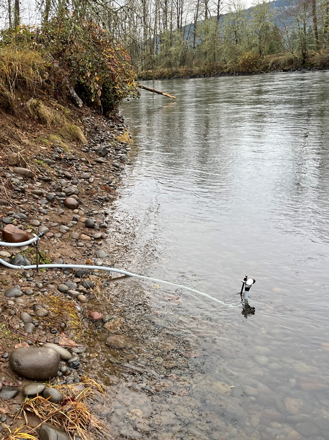
The #USGS is listening to rivers to understand how flows transport bedload sediment, which is fundamental to ecosystem structure and health. Pictured is a hydrophone installation in the #McKenzieRiver.
#ScienceSaturday #WillametteRiverBasin
Learn more! ow.ly/C9fA50Ue8ry
3
128