
May 10
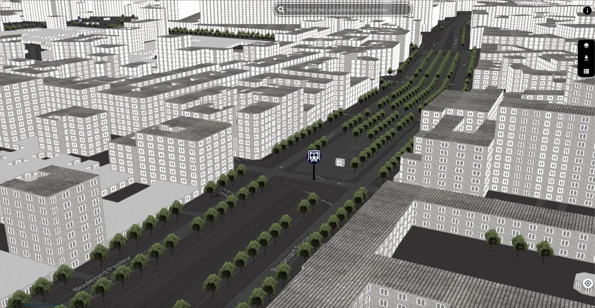
🏙️🛰️ Mapas urbanos en 3D con R
Combinando osmdata, mapdeck y la potencia de Mapbox, es posible construir visualizaciones urbanas en 3D usando información real de edificios y su altura.
📍 Ideal para:
• Análisis de densidad urbana
• Planeación territorial
• Estudios de sombra, calor y verticalización
#RStats #GIS #Mapbox #UrbanData #Cartagena #DataVisualization #3DMaps
1
7
310

Mar 4
🗺️ Curso Mapas en Acción:
→ estacion-r.com/courses/a183e…
🔗 Links de los paquetes:
📦 {mxmaps} → github.com/diegovalle/mxmaps
📦 {inegiR} → cran.r-project.org/package=i…
📦 {osmdata} → cran.r-project.org/package=o…
📦 {electorAr} → cran.r-project.org/package=e…
7
34
928
Mar 4
[TIP de R] ¿Tus datos tienen una dimensión geográfica? 🗺️
Estos 4 paquetes te van a cambiar cómo trabajás con datos territoriales en R:
✔️ {mxmaps} 🇲🇽- Cartografía mexicana lista para usar. Mapas de estados y municipios con integración directa a ggplot2. Solo disponible vía GitHub.
✔️ {inegiR} 🇲🇽 - Acceso a la API del INEGI desde R. Descargá indicadores, series temporales y datos del censo mexicano sin salir del script.
✔️ {osmdata} 🌎 - Datos de OpenStreetMap en R. Calles, edificios, puntos de interés: cualquier lugar del mundo, directo desde la Overpass API.
✔️ {electorAr} 🇦🇷- Datos electorales argentinos históricos. Resultados por provincia y departamento con funciones listas para analizar y visualizar.
💡 Si querés aprender a combinar este tipo de datos en mapas reales, mañana arranca Mapas en Acción con Tomás Bustos.
👉🏼4 encuentros, jueves 19 hs ARG UTC-3).
¡Asegurá tu lugar!
↪ info del curso y los paquetes en comentarios 👇🏼
#RStats #RStatsES #Rtips

1
9
52
1,672
1 Aug 2025
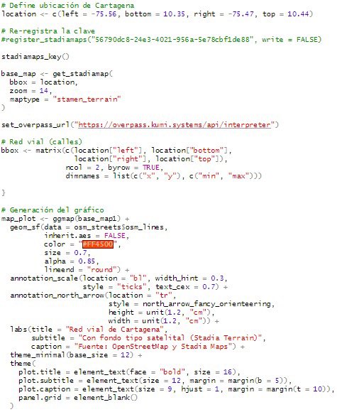
🗺️ Red vial de #Cartagena en R
Este ejercicio combina varias librerías en R (#osmdata, #sf, #ggspatial y #ggplot2) para construir un mapa de la red vial, con base en datos de #OpenStreetMap
🧭 Ideal para análisis urbanos y planificación territorial.
#DataViz #AnálisisEspacial

4
261

10 Apr 2025
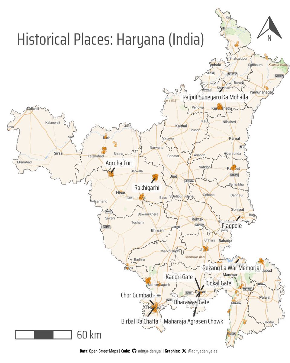
#dataviz How to use {mapview} to plot interactive maps - a basic example of historical sites in Haryana (India) using data from @openstreetmap with {osmdata}
Full code & Interactive View: tinyurl.com/r-mapview-intera…
Tools #rstats #ggplot2 #terra #tidyterra #osmdata #leaflet #mapview
5
37
2,070

8 Apr 2025
4️⃣ Retrieve road data from OSM. We define a bounding box for Amsterdam and fetch major roads using the osmdata package.
Why it matters: Urban planning and transportation studies benefit from visualizing road networks.
💻 # 2. OpenStreetMap (OSM)
#-----------------------
# install osmdata and load packages
remotes::install_github("ropensci/osmdata")
pacman::p_load(osmdata, tidyverse)
# define area of interest (Amsterdam)
bbox <- osmdata::getbb("Amsterdam, Netherlands")
# fetch OSM road data
roads_data <- osmdata::opq(bbox) |>
osmdata::add_osm_feature(
key = "highway",
value = c("motorway", "primary", "secondary")
) |> osmdata::osmdata_sf()
roads <- roads_data$osm_lines
# plot roads
ggplot(data = roads)
geom_sf(color = "deeppink1")
theme_void()
labs(title = "Amsterdam Major Roads")
1
5
541
26 Mar 2025
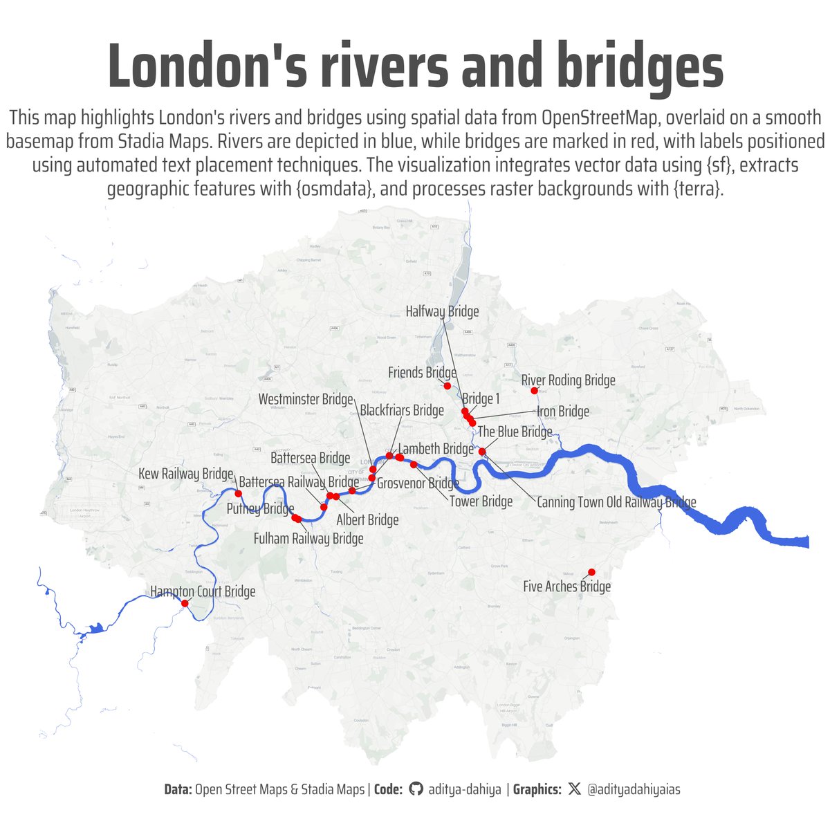
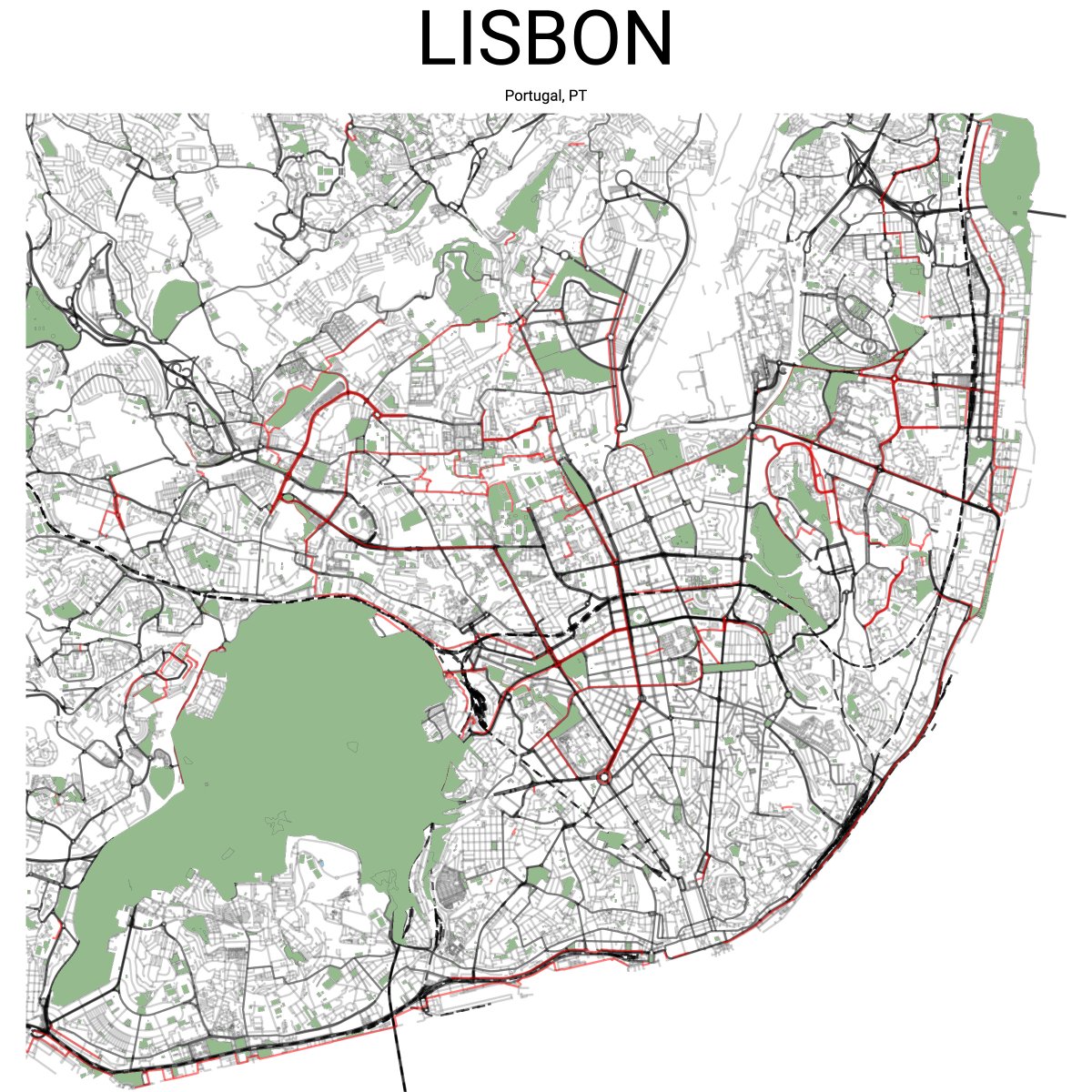
#maps Exploring the different Bridges in London through @openstreetmap data🏰over a basemap by @StadiaMaps
Code 🔗 tinyurl.com/viz-london-bridg…
Tools: #rstats, #ggplot2, #sf, #osmdata, #ggrepel, #terra, #ggmap
6
51
2,111
23 Mar 2025
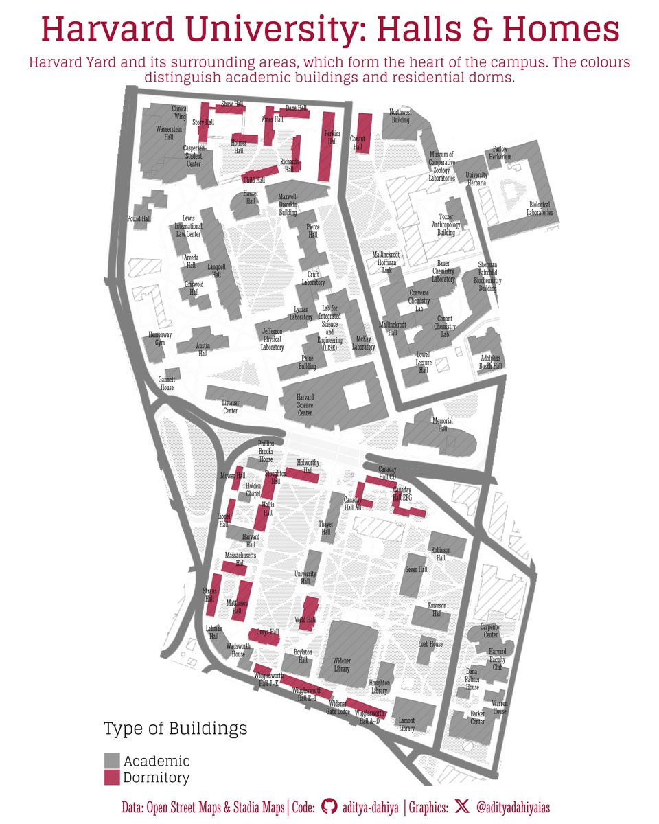
#DataViz Mapping @Harvard University's geographical heart: the Harvard Yard and dorms using #ggplot2 and #opensource data from @openstreetmap & background map from @StadiaMaps
Full Code 🔗 tinyurl.com/hv-yd-mp1
Tools #rstats {ggmap} {ggrepel} {sf} {terra} {tidyterra} {osmdata}
7
47
1,818
22 Mar 2025
#maps Exploring the rich history of the City of London through @openstreetmap data🏰over a watercolor basemap by @StadiaMaps.
Code 🔗 tinyurl.com/city-lnd-hist
Tools: #rstats, #ggplot2, #sf, #osmdata, #ggrepel, #terra, #ggmap

3
37
1,493
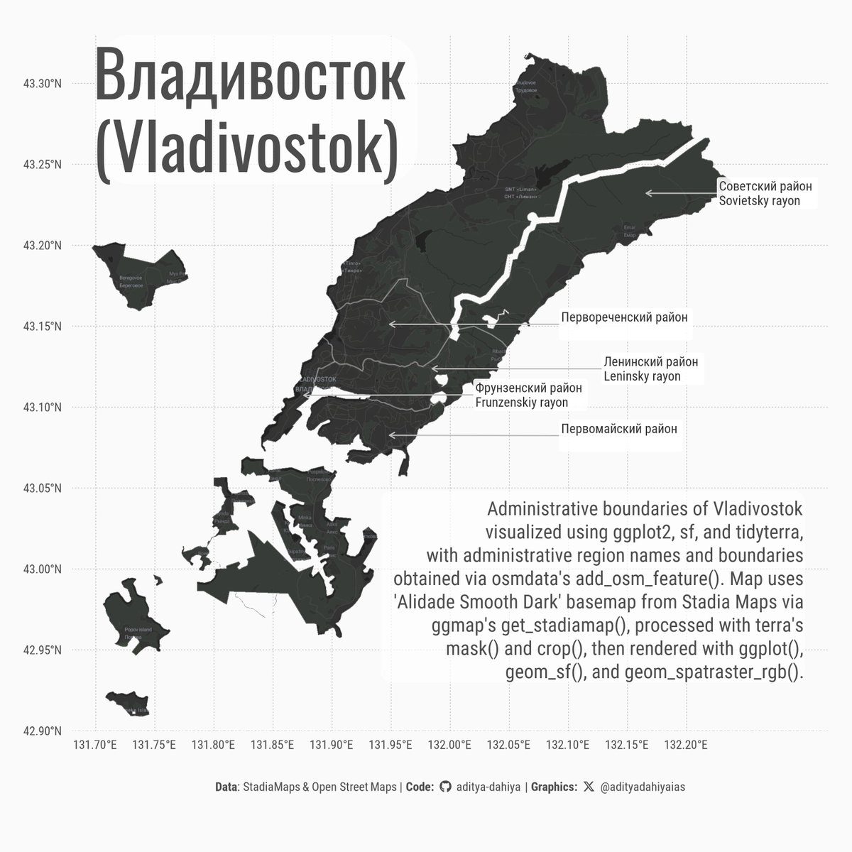
19 Mar 2025
#DataViz showing Vladivostok using {osmdata} for boundaries, {sf} for spatial operations, and {ggplot2} {tidyterra} (by @dhernangomez). The dark basemap from StadiaMaps ({ggmap} @davidjkahle) cropped with {terra} raster ops.
Data: @openstreetmap
Code 🔗 tinyurl.com/map-vostok
1
22
1,204

1 Dec 2024
📍🌍📍🌍📍🗺️📍🌍📍
Just maintaining the standard as usual, UCCyouthmappers engage it's members again yesterday☺️
where members got to know how to download OSM data and perform buffer analysis😌🗺️
#BufferAnalysis
#OSMdata
we don't just build maps, we build mappers😌🌍


2
7
26
319
30 Nov 2024
📍🌍❗️🌍❗️🗺️❗️🌍❗️🌍📍
You called for it and we delivered😊
Aspiring mappers were taught how to use the quality data we upload to OSM and how it can be utilized efficiently for spatial analysis🗾
#SpatialAnalysis🗺️
#OSMdata
#UCCyouthmappers
#WeDon’tJustBuildMapsWeBuildMappers
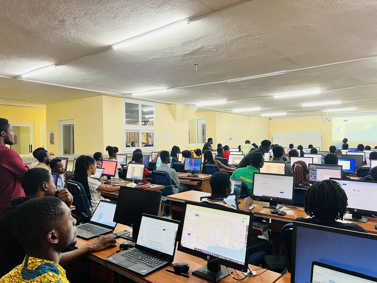


29 Nov 2024

📍🌍📍🗺️📍🌍📍🗺️📍🌍
Youthmappers is not only about mapping but the use of quality data we upload to OSM😊
It focuses on: Using OSM Data in ArcMap.
It showcase how OSM contributions can be utilized for spatial analysis in ArcGIS software.
#WeDon’tJustBuildMaps
#AnalysisAndMaps🗾
1
6
27
570
24 Nov 2024
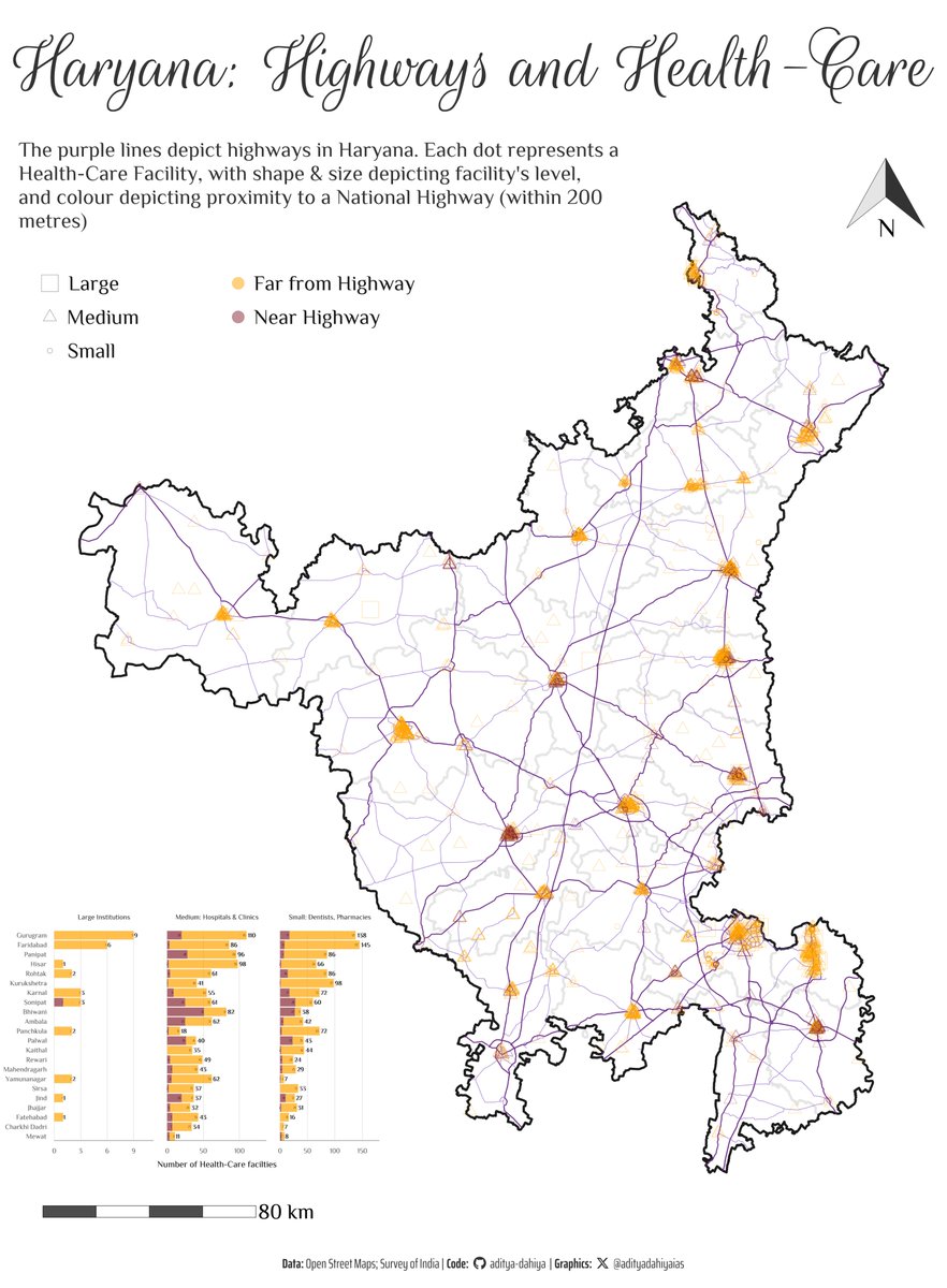
#dataviz A detailed tutorial and project on mapping health-facilties, highways and their proximity with #R and #sf geo-computation.
Data: @openstreetmap @india_soi
Code 🔗 tinyurl.com/health-highway
Tools #rstats #ggplot2 {sf} {ggspatial} {osmdata} by @rOpenSci
1
11
450

5 Nov 2024
OpenStreetMap (OSM) is an open world geographic database updated and maintained by a community of volunteers.
We can use the #osmdata package in #R to retrieve OSM data including roads, shops, railway stations, and much more.
The #available_features() function can be used to get the list of recognized features in OSM.
The #available_tags() function lists out the tags associated with each feature.
This list can be found in the #OSM wiki.
#geospatial
9
33
1,408

7 Oct 2024
🎯 Respecter autant que possible les conventions OSM pour la modélisation 3D sur @OSMdata 👉 wiki.openstreetmap.org/wiki/…
☒ Les géomètries conformes
☒ Les toits de type “flat”
☒ Texture unique pour toits et facades; avec 5-6 textures max pour uniformiser le rendu.
1
3
5
480

8 Sep 2024
Working together with @openstreetmap data group we can make #osmdata better. #StateoftheMap #SotM #SotM2024
3
10
340

3 Sep 2024
Quedan bien chidos los mapas con elementos sacados de Open Street Map (con el paquete {osmdata}) #rstats
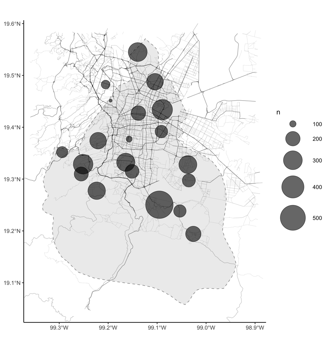
6
44
437
17,888

9 Aug 2024
en el cumple numero 20 de #openstreetmap hice un mapa on OsmData de mi querida Ciudad.
@openstreetmap @munireconquista
@CrisAlida28

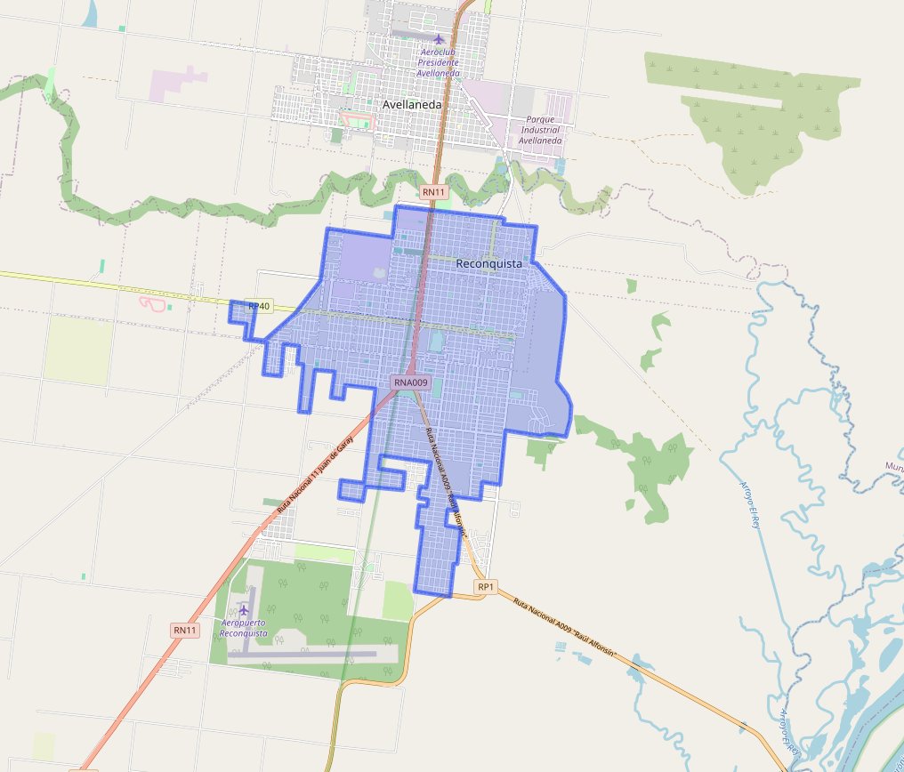
1
6
165


30 May 2024
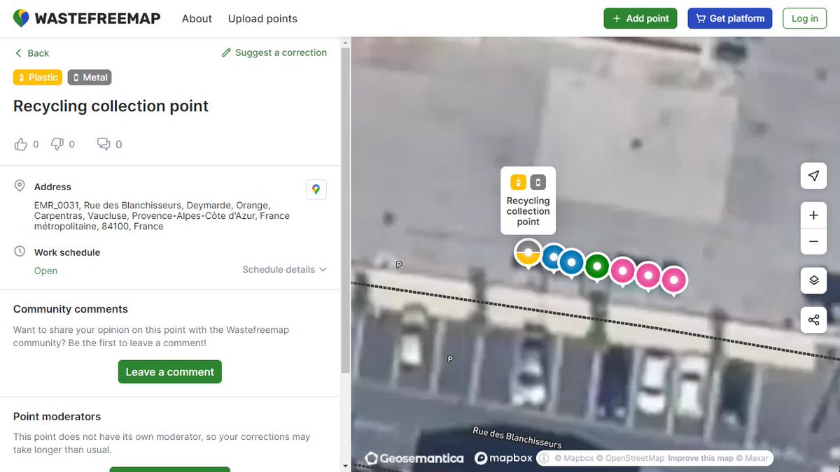
Quel plaisir de pouvoir utiliser le site wastefreemap.com basé sur OpenStreetMap sachant que la donnée est actualisée avec son implication et que le rendu valorise la richesse de la qualification. @armeltayou @OSMdata @tonyemery @XDurang

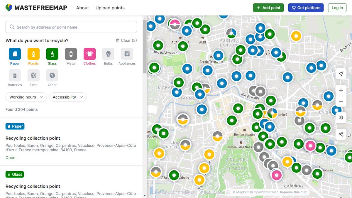

1
5
9
636