
Delighted to share my latest article in @ConversationUK on the growing challenge of organised fly-tipping in the UK.
Read more: theconversation.com/criminal…
@TheSmithSchool @OxGeography @UniofOxford #FlyTipping #WasteCrime #AI #Drones #GeospatialIntelligence #UK
19

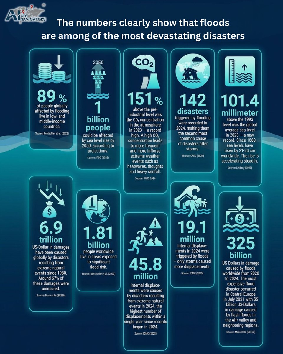
Floods are becoming one of the biggest risks facing communities, cities, and infrastructure.
The numbers are hard to ignore.
In 2024, floods triggered 142 disasters worldwide, making them the second-most common disaster after storms.
Between 2020 and 2024, flood-related damage reached more than US$325 billion.
And by 2050, up to 1 billion people could be affected by sea level rise.
These are not just environmental numbers. They are human, economic, and planning challenges.
Reducing flood risk means acting earlier, planning smarter, and using better data to understand where people, assets, and infrastructure are most exposed.
AI, geospatial intelligence, early warning systems, local knowledge, and nature-based solutions all have a role to play.
Floods cannot always be prevented, but their impact can be reduced.
Now is the time to turn risk data into real action.
What steps is your city, organization, or community taking to prepare for future flood risk?
@UNDRR
@WMO
@NASAEarth
@UNFCCC
@AiGeoNavigators
#FloodRisk #ClimateResilience #DisasterRiskReduction #GeospatialIntelligence #EarlyWarningSystems #ClimateAdaptation #UrbanResilience #NatureBasedSolutions #RiskManagement #SustainableCities #ClimateAction #GIS #RemoteSensing #DataForGood #ResilientInfrastructure
9

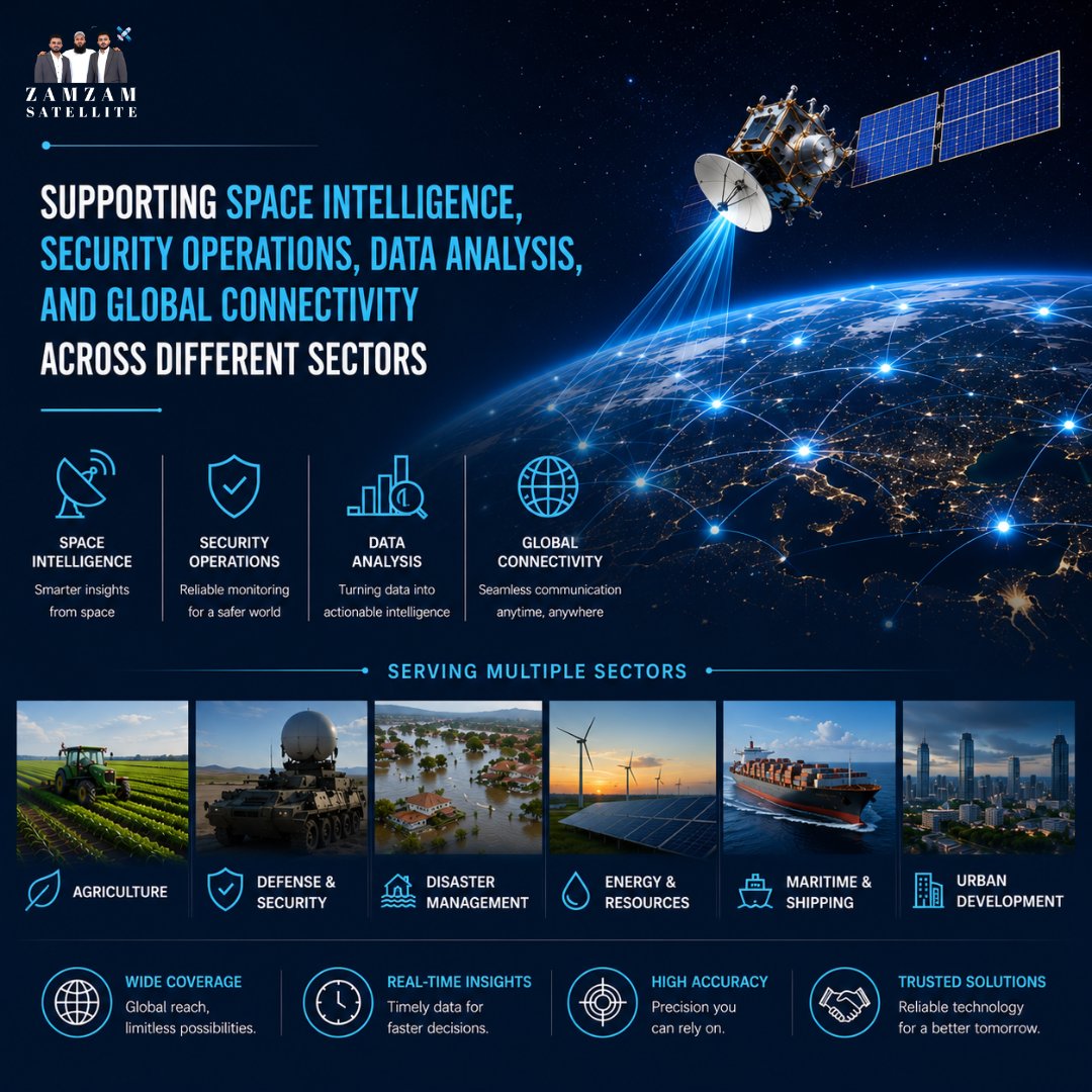
From space intelligence and security operations to advanced data analysis and global connectivity, Zam Zam Satellite delivers actionable insights that help organizations make smarter decisions across multiple industries.
Empowering governments, businesses, and institutions with reliable geospatial intelligence, satellite imagery, and cutting-edge monitoring solutions for a more connected world.
zamzamsatellite.com/
#SatelliteTechnology #SpaceIntelligence #GeospatialIntelligence #SatelliteData #GlobalConnectivity #RemoteSensing #EarthObservation #DataAnalytics #SecurityOperations #GIS #ZamZamSatellite #AI
10

Jun 12
$PL ✨
Satellite-Based Earth Observation Market Expected to Reach $10.01 Billion by 2030
According to a new industry report, the global satellite-based Earth observation market is projected to grow to approximately $10.01 billion by 2030, representing a CAGR of 7.35%.
Key growth drivers:
✅ Increasing demand for government and defense intelligence
✅ Growing use of geospatial analytics and AI
✅ Climate monitoring and environmental applications
✅ Infrastructure, agriculture, and disaster response services
Why it matters for Planet Labs:
• Planet operates one of the world’s largest Earth observation satellite fleets
• Provides daily global imagery and geospatial intelligence services
• Expanding AI-powered analytics capabilities
• Growing government, defense, and intelligence customer base
As demand for Earth observation data continues to grow, companies with scalable satellite constellations, analytics platforms, and recurring government contracts may be well positioned to benefit from the long-term industry expansion.
einpresswire.com/article/918…
#PL #PlanetLabs #EarthObservation #GeospatialIntelligence #SpaceTech #AI
4
447
Jun 11
$PL ✨
Planet Labs Expands San Francisco Headquarters to Boost Satellite Manufacturing
Key highlights:
✅ Planet now occupies three floors at its SoMa headquarters in San Francisco
✅ The company is opening a second facility in Berlin
✅ Expansion is intended to increase satellite manufacturing capacity and meet growing demand
✅ Defense, intelligence, and government contracts are driving growth
As demand for Earth observation and geospatial intelligence continues to accelerate, Planet is investing in manufacturing scale and global operations.
The expansion comes as Planet reports strong revenue growth, a growing backlog, and increasing adoption across defense and national security customers.
Planet continues evolving from a satellite imagery provider into a global geospatial intelligence platform.
bizjournals.com/sanfrancisco…
#PL #PlanetLabs #SpaceTech #DefenseTech #GeospatialIntelligence #Satellite
1
6
896

“Millions of people live with the constant threat of flooding.”
What if we could predict risks before disaster strikes?
In this clip from Spacefront Conversation, MJ Akter, COO of Spiral Blue shares how a real-world problem affecting millions inspired a mission to leverage space technology for better decision-making on Earth.
By combining Earth observation, advanced data analytics, and next-generation geospatial intelligence, we're moving toward a future where communities can better prepare for floods, protect critical infrastructure, and save lives.
The most powerful space technologies aren't just about exploring beyond Earth.
They're about making life better on Earth.
#SpaceTech #ClimateTech #FloodRisk #EarthObservation #GeospatialIntelligence #DisasterManagement #Innovation #SpaceIndustry #SpiralBlue #WomenInSpace #SpacefrontConversation #EarthIntelligence
10
More Insights from Our FAO Flood Exposure Dashboard | Built by AI Geo Navigators
Following up on the flood map we shared recently, here’s the complete set of interactive maps from the same dashboard. Using the latest FAO report data, we’ve visualized how floods overlap with:
Exposed populations
Croplands at risk
Rural communities
Our team at AI Geo Navigators designed and developed this full geospatial dashboard to turn complex FAO datasets into clear, actionable intelligence for understanding climate risks to agriculture and rural livelihoods.
What trends do you see across the population, cropland, and rural exposure layers? How can we strengthen resilience in these flood-prone areas? Would love your thoughts in the comments
📍 Dashboard by AI Geo Navigators
Your feedback makes our dashboard and maps better, drop your thoughts in the comments or reach out directly. Follow AI Geo Navigators for more data-driven insights on climate, and beyond!
@FAO
@WFP
@UNDRR
@CopernicusEMS
@CopernicusEU
@AIforGood
#GeospatialIntelligence #FAO #FloodMapping #ClimateResilience #Agriculture #RuralDevelopment #GeoAI #FoodSecurity #AIGeoNavigators
1
1
38

Space42 announces full operations of 3 foresight satellites
gccbusinessnews.com/space42-…
#Space42 #ForesightSatellites #EarthObservation #SAR #SatelliteTechnology #GeospatialIntelligence #SpaceTech #GCCBusinessNews @space42ai

22

Space42 expands foresight satellite constellation with 3 new SAR satellites
emiratitimes.com/space42-exp…
#Space42 #ForesightConstellation #EarthObservation #SatelliteTechnology #SpaceTech #UAESpaceSector #GeospatialIntelligence #SARSatellites #EmiratiTimes @space42ai

18

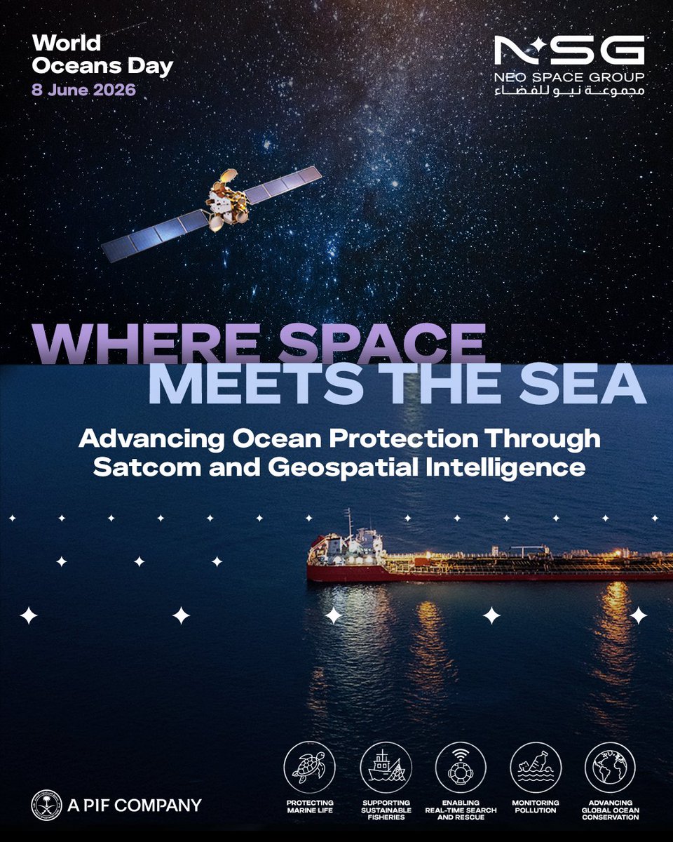
DYK?
Satellites and geospatial intelligence are essential to safeguarding our oceans - from protecting marine life and supporting sustainable fisheries to enabling real‑time search and rescue, monitoring pollution, and global ocean conservation.
#NeoSpaceGroup (#NSG) advances space‑enabled ocean monitoring through satellite communications, and geospatial insights via NSG Geospatial Services and the NSG UP42 marketplace - strengthening safety, sustainability, and life‑saving action across our seas - in full alignment with Saudi Vision 2030.
@NSG_Geospatial #NSGUP42
#aPIFcompany #WorldOceansDay #geospatialintelligence
#satellitecommunications #OceanConservation #SustainableFisheries #searchandrescue #SaudiVision2030
1
1
199
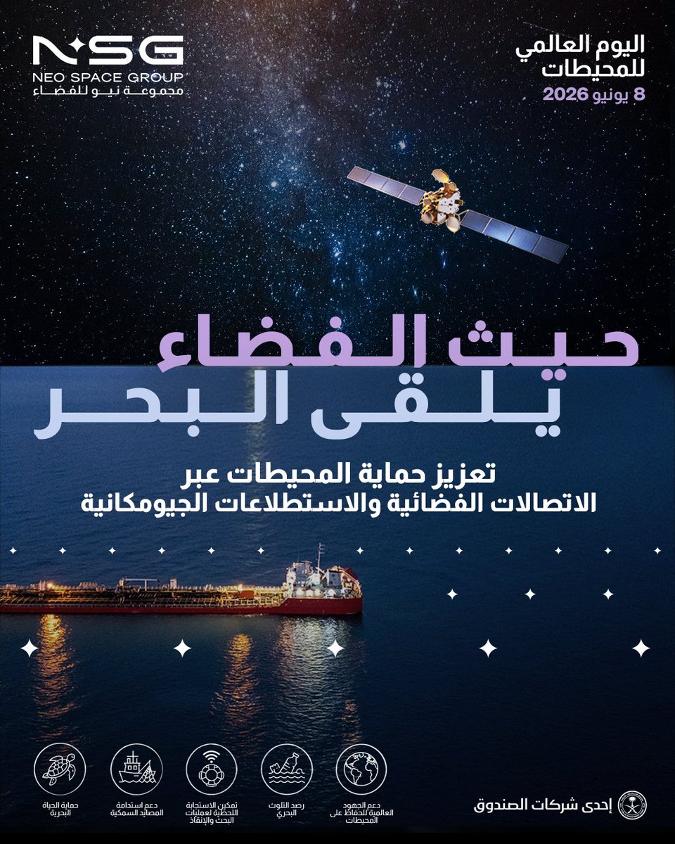
هل تعلم؟
تُعد الأقمار الصناعية والاستطلاعات الجيومكانية من اساسيات حماية المحيطات والبحار، إذ تسهم في الحفاظ على الحياة البحرية، واستدامة المصايد السمكية، وتمكين عمليات البحث والإنقاذ اللحظية، ورصد التلوث، وتعزيز الجهود العالمية للحفاظ على المحيطات.
وتسهم مجموعة نيو للفضاء (NSG) في تطوير قدرات مراقبة البحار والمحيطات المدعومة بتقنيات الفضاء من خلال حلول الاتصالات عبر الأقمار الصناعية، والرؤى الجيومكانية المتقدمة التي تقدمها خدمات NSG الجيومكانية ومنصة NSG UP42، بما يعزز السلامة البحرية والاستدامة البيئية ويدعم الجهود لحماية الأرواح في مختلف البيئات البحرية، تماشياً مع مستهدفات رؤية السعودية 2030.
@NSG_Geospatial
#مراقبة_الأرض
#مجموعة_نيو_للفضاء
#إحدى_شركات_صندوق_الاستثمارات_العامة
#رؤية_السعودية_2030
#NSG
#NSGGeospatialServices
#NSGUP42
#WorldOceansDay
#SatelliteCommunications
#GeospatialIntelligence
1
3
408

Planet Labs (NYSE: PL) crashes 25% after a record quarter and a 400% run business-news-today.com/plan… $PL #PlanetLabs #SatelliteData #GeospatialIntelligence #SpaceStocks #DefenseTech #AI #NYSE #EarthObservation #GrowthStocks
183
Nayef Al-Rodhan retweeted

How #AI is shaping the future of #GeoSpatialIntelligence;
From AI adoption & explainability to new commercial satellite contracts,
Reporting from #GEOINT2026 on how intelligence leaders are shaping the future of #SpaceBased geospatial intelligence.
breakingdefense.com/2026/06/…
2
1
299
Jun 5
$PL ✨
🚨Planet Labs ATM/Shelf Registration Breakdown
Planet Labs has filed a new ATM equity program providing up to $1.5 billion of financing flexibility.
✅ Not an immediate stock offering
✅ Shares can only be sold if and when management chooses
✅ Up to $1.5B of capital raising capacity
✅ Intended for growth initiatives and potential acquisitions
✅ Could support Pelican constellation expansion and AI investments
At a share price of approximately $43.5, the full $1.5B authorization would translate into roughly 34–35 million shares.
Based on approximately 333 million shares outstanding today:
Estimated maximum dilution:
• Around 10%
Importantly, this represents a theoretical worst-case scenario if the entire authorization were utilized near current prices.
With more than $500M in cash on the balance sheet, this appears less like a survival financing move and more like securing capital for future growth opportunities.
Not a stock offering today, but a $1.5B growth war chest for future expansion and potential M&A.
#PL #PlanetLabs #SpaceTech #DefenseTech #AI #GeospatialIntelligence
d18rn0p25nwr6d.cloudfront.ne…

3
749

Jun 5
📘Fine-Tuning #LLM-Assisted Chinese Disaster #Geospatial Intelligence Extraction and Case Studies
By Yaoyao Han, Jiping Liu, An Luo, Yong Wang and Shuai Bao
👉See the paper: mdpi.com/2220-9964/14/2/79
#naturaldisasters #largelanguagemodels #geospatialintelligence #socialmedia

2
3
59
Jun 4
$PL ✨
Planet Labs announced it has secured an 8-figure NGA contract extension for maritime surveillance, along with a new award supporting crisis response monitoring.
Key highlights
✅ Continued partnership with the U.S. National Geospatial-Intelligence Agency (NGA)
✅ Extension of maritime surveillance and monitoring capabilities
✅ New contract focused on crisis response monitoring
✅ Expands Planet's role in defense and intelligence applications
✅ Reinforces growing demand for satellite imagery and geospatial intelligence
Government and defense contracts continue to be an important growth driver for Planet's data and AI-enabled analytics business.
#PlanetLabs #PL #NGA #DefenseTech #GeospatialIntelligence #SatelliteData
investors.planet.com/news/ne…
6
593

Jun 4
Space42 is back today at the Global Data Festival and Kenya Space Expo and Conference 2026 in Nairobi. Showcasing the latest space-based capabilities, we are in conversations with industry innovators, strategic partners, and regulators about driving impact across the African continent.
Find us at Stands 21 and 22, co-exhibiting with @Microsoft, at The Edge Hotel and Convention Centre, Nairobi.
June 2–5, 2026.
@SpaceAgencyKE
#Space42 #GlobalDataFestival #Kenya #GeospatialIntelligence
1
3
223
Jun 3
$PL ✨
Planet Labs continues to advance its next-generation Pelican constellation.
According to a recent analysis, Pelican-11 has been shipped to the launch site and is expected to serve as a technology demonstration mission for Planet’s second-generation high-resolution fleet.
Key takeaways:
✅ Pelican-11 is designed to support future high-resolution imaging capabilities
✅ The mission is intended to improve imaging quality, revisit rates, and on-orbit processing
✅ Planet is seeing growing interest from government customers, including the Swedish Army and the Greek government
✅ The long-term opportunity may come from converting technical advancements into larger, recurring government contracts
The significance of Pelican-11 is not just the satellite itself.
It is another step toward expanding Planet’s high-value geospatial intelligence business serving defense, intelligence, and government customers worldwide.
#PL #PlanetLabs #Pelican #GeospatialIntelligence #EarthObservation #DefenseTech #SpaceTech
simplywall.st/stocks/us/comm…
1
595
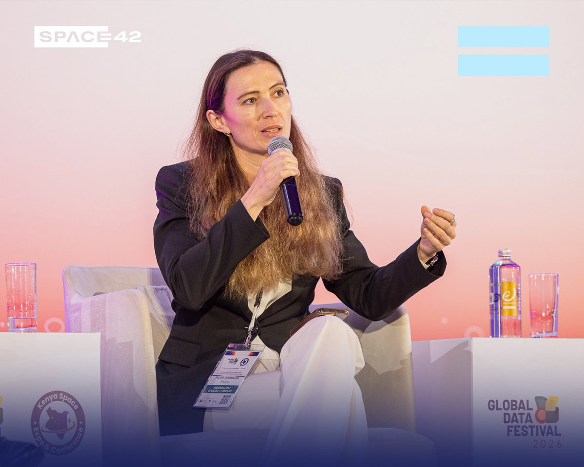
Jun 3
What does it actually take to build a national data ecosystem that serves its people?
Dr. Yuliya Tarabalka, Vice President of Geospatial Solutions at Space42, joined the plenary panel on Unlocking Investments in Data Ecosystem at the Global Data Festival and Kenya Space Expo and Conference 2026 in Nairobi. She highlighted Space42’s perspective on the significance of sovereign data infrastructure and what it takes to build it right.
The session made the case to go further than investing only in the sensing layer. The AI and analytics infrastructure including platforms such as GIQ that turn data into actionable intelligence, is where sovereign capability is built.
The panel was joined by Dr. Bonface Makokha, Principal Secretary, State Department for Economic Planning, Hon. Gideon Ochanda, Member of Parliament for Bondo Constituency, Paula McLeod, Head of the Statistics Profession in the UK’s Foreign, Commonwealth and Development Office, and moderated by Priscilla Idele, Chief of Data, Population, and Development Branch, UNFPA.
@SpaceAgencyKE
@Microsoft
#Space42 #GlobalDataFestival #Kenya #GeospatialIntelligence

3
165

The future of #geospatialintelligence is being shaped in contested skies. Come see how.
We're live at the Indo Pacific GeoIntelligence Forum 2026 (June 2-3, Manekshaw Centre, New Delhi).
At Booth #14, explore the #Q6V2GEO, #Q6V3 (EW), and #SWITCHV2 - our advanced #UAV platforms built for #ISR, #geospatialintelligence, and #electronicwarfare mapping in complex operational environments.
On June 3, our Group Product Manager, Geospatial Solutions, Pradeep Pandurangi, speaks at Session Track 2.4 on Precise Geospatial Intelligence in Contested Environments (1330-1415 hrs), covering #GNSS spoofing, jamming, and #GPSdenied operations.
As operational environments grow more contested, #resilient geospatial intelligence and #autonomous systems are no longer optional.
We look forward to connecting with defence leaders, technology experts, and practitioners shaping the future of geospatial intelligence in the Indo-Pacific. If you'd like to set up a one-on-one conversation with our experts, drop us a DM or visit us directly at Booth #14
@geospatialworld


2
10
816