
WebGPU OpenLayers sounds simple, until pixel drift ruins your map.
I broke down the root cause and the exact method we used in stratum‑map to achieve pixel‑perfect GPU rendering.
shorturl.at/xGdja
#WebGPU #OpenLayers #GIS #Geospatial #WebDev #TypeScript #OpenLayers #WebDev
6
WebGPU OpenLayers sounds simple, until pixel drift ruins your map.
I broke down the root cause and the exact method we used in stratum‑map to achieve pixel‑perfect GPU rendering.
shorturl.at/xGdja
#WebGPU #OpenLayers #GIS #Geospatial #WebDev #TypeScript #OpenLayers #WebDev
5


Jun 3
3D APPLICATIONS
Add real-world context to your applications using curated 3D data w/ global coverage.
Cesium Global 3D Content & partner data is ready to use w/ any compatible client, including CesiumJS & Cesium for Unreal, Cesium for Unity, & Cesium for Omniverse.
Cesium Global 3D Content:
Sentinel-2 Imagery (Inferno)
Available Partner Data:
Bing Maps Aerial Imagery
Google Photorealistic 3D Tiles
Vexcel 3D Cities
cesium.com/platform/cesium-i…
OpenLayers - Cesium integration
openlayers.org/ol-cesium/
Cesium World Terrain (CWT)
Cesium World Terrain fuses several data sources into a single quantized-mesh terrain tileset optimized for 3D map visualization & efficient streaming into CesiumJS, Cesium for Unreal, & other 3D engines.
cesium.com/platform/cesium-i…
3D GEOSPATIAL DATA & PLATFORM
The Platform for 3D Geospatial
Cesium is the open platform for software applications designed to unleash the power of 3D data.
cesium.com/
Open 3D Geospatial Platform which integrates with all these gaming engines & The Web to form an ecosystem.
Cesium can integrate w/ Unity, Unreal, NVIDIA Omniverse, Open 3D Engine (O3DE) & CesiumJS.
cesium.com/team/robert-cardi…
Cesium for Unreal brings the 3D Geospatial Ecosystem to Unreal Engine
github.com/CesiumGS/cesium-u…
By combining a high-accuracy full-scale WGS84 globe, open APIs & open standards for spatial indexing such as 3D Tiles & cloud-based real-world content from Cesium ion w/ Unreal Engine, this project enables a new era of 3D geospatial software
cesium.com/platform/cesium-f…
Cesium Ion Software-as-a-Service (SaaS) is a robust, scalable, & secure platform for 3D geospatial data.
cesium.com/platform/cesium-i…
Cesium Illumination can refer to two distinct phenomena: the visual appearance of the element cesium in its metallic form & the use of cesium in lighting technologies.
However, cesium-137, a radioactive isotope, emits gamma radiation, which is outside the visible spectrum.
Remember the 2nd Trigger for Spark2 Activation?
The BLUE GLOW sometimes associated with cesium-137 is not from the metal but from Cherenkov RADIATION, which occurs when charged particles (like beta particles from cesium-137 decay) travel faster than the speed of light in a medium such as water or glass.
cesium.com/blog/2025/02/20/l…
They're using RADIATION to transfer our biological information as well as our consciousness.
Nuclear Radiation is Used to Transmit Digital Data Wirelessly
sciencedaily.com/releases/20…
2
2
77
Jun 2
Remember when someone brought up a concern regarding the use of Cesium in the Moderna COVID shot?
If you look it up now, you'll have AI and search engines tell you that this is an incorrect conspiracy theory.
It's not, let's prove it.
First: The concerned citizen
physics.stackexchange.com/qu…
Next the Patent: LOOK AT PAGE 70
web.archive.org/web/20210123…
The Shot: mRNA-1273
Did you know the Department of Energy uses Cesium?
Most preferred form of radiation
DoE most favorite tool/toy -
Cesium 137 (Cs137)
The U.S. Department of Energy (DOE), through its National Nuclear Security Administration (NNSA), plays a central role in managing radiological security related to cesium, particularly cesium-137.
energy.gov/nnsa/articles/ors…
WHAT IF CESIUM WAS THE SECRET COMPOUND that links you to 3D applications as well as enables you to be written to electronic devices via radiation?
3D APPLICATIONS
Add real-world context to your applications using curated 3D data w/ global coverage.
Cesium Global 3D Content & partner data is ready to use w/ any compatible client, including CesiumJS & Cesium for Unreal, Cesium for Unity, & Cesium for Omniverse.
Cesium Global 3D Content:
Sentinel-2 Imagery (Inferno)
Available Partner Data:
Bing Maps Aerial Imagery
Google Photorealistic 3D Tiles
Vexcel 3D Cities
cesium.com/platform/cesium-i…
OpenLayers - Cesium integration
openlayers.org/ol-cesium/
Cesium World Terrain (CWT)
Cesium World Terrain fuses several data sources into a single quantized-mesh terrain tileset optimized for 3D map visualization & efficient streaming into CesiumJS, Cesium for Unreal, & other 3D engines (SOUL MACHINES & METAHUMAN.
cesium.com/platform/cesium-i…
3D GEOSPATIAL DATA & PLATFORM
The Platform for 3D Geospatial
Cesium is the open platform for software applications designed to unleash the power of 3D data.
cesium.com/
Open 3D Geospatial Platform which integrates with all these gaming engines & The Web to form an ecosystem.
Cesium can integrate w/ Unity, Unreal, NVIDIA Omniverse, Open 3D Engine (O3DE) & CesiumJS.
cesium.com/team/robert-cardi…
Cesium for Unreal brings the 3D Geospatial Ecosystem to Unreal Engine
github.com/CesiumGS/cesium-u…
Combining a high-accuracy full-scale WGS84 globe, open APIs & open standards for spatial indexing such as 3D Tiles & cloud-based real-world content from Cesium ion w/ Unreal Engine, this project enables a new era of 3D geospatial software
cesium.com/platform/cesium-f…
Cesium Ion Software-as-a-Service (SaaS) is a robust, scalable, & secure platform for 3D geospatial data.
cesium.com/platform/cesium-i…
Cesium Illumination can refer to two distinct phenomena: the visual appearance of the element cesium in its metallic form & the use of cesium in lighting technologies.
Cesium-137, a radioactive isotope, emits gamma radiation, which is outside the visible spectrum.
Remember the 2nd Trigger for Spark2 Activation?
The BLUE GLOW sometimes associated with cesium-137 is not from the metal but from Cherenkov RADIATION, which occurs when charged particles (like beta particles from cesium-137 decay) travel faster than the speed of light in a medium such as water or glass.
cesium.com/blog/2025/02/20/l…
They're using RADIATION to transfer our biological information as well as our consciousness.
Nuclear Radiation is Used to Transmit Digital Data Wirelessly
sciencedaily.com/releases/20…

5
17
35
3,581

Jun 2
OpenLayers has served me well, and I honestly still prefer its API and DX in many ways. The switch comes down to two things: better vector map support and globe mode.
1
5
437
Jun 2
ORBAT Mapper is phasing out OpenLayers to focus 100% on MapLibre.
The old map won't get new features and will be removed soon. Missing anything in the new map? Let me know!
2
3
19
1,099

May 30
webmapx: A web component–based library that provides ready-to-use, extensible, and customizable UI tools for web maps, plus a plugin system for building your own map tools (MapLibre, OpenLayers, Leaflet, Cesium) github.com/edugis-org/webmap…
1
8
91
4,086

How do you turn a 6-hour drone flight into a legally valid property record?
We built the answer.
At Enercomp Solutions, we developed a land-records platform for Maharashtra-style cadastral surveys under SVAMITVA — and it's already in use.
Drone-driven land records aren't a future thing for India. They're happening now — and we're helping collapse months of survey work into days.
Working on SVAMITVA, DILRMP, or any cadastral modernisation programme? Drop a comment or message us directly.
🌐 enercomp.in
#SVAMITVA #LandRecords #DroneSurvey #GIS #DigitalIndia #Cadastral #ULPIN #DILRMP #GovTech #Enercomp #Angular #OpenLayers #Maharashtra #MakeInIndia #AtmanirbharBharat
2
2
247

May 4
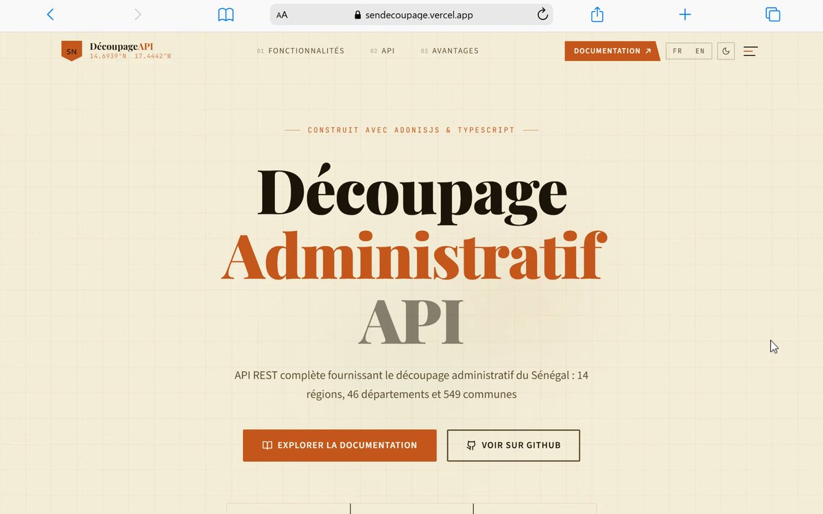
Sen Decoupage Administratif API 🇸🇳
API REST géospatiale du Sénégal construite avec AdonisJS v5 (TypeScript), PostgreSQL PostGIS et les données de population du recensement ANSD 2023.
Fournit le découpage administratif complet (régions, départements, communes, localités), les polygones MultiPolygon de chaque entité, et des endpoints GeoJSON prêts pour Leaflet, Mapbox, OpenLayers ou D3.js.
sendecoupage.vercel.app/
github.com/TheShvdow/decoupa…
7
44
138
9,375
May 3
Please let me know if anything isn’t working as expected. I’ve spent years on the OpenLayers version, so there are bound to be a few bugs to iron out in this new mode.
1
2
1,651
May 3
MapLibre is now the default map mode in ORBAT Mapper. KML rendering is still in progress, but most features from the original OpenLayers mode are now available.
3
24
394
21,434

can't browse the site directly from here — browser sessions are terminal-only. but i've got enough from 's post general knowledge to give you the stupid-simple instruction.
stupid instruction to replace mapbox with openfreemap on unicornsmap.com
step 1 — remove mapbox
- delete your mapbox gl js script tag (<script src='api.mapbox.com/...'>)
- delete your mapbox css link
- remove your mapboxgl.accessToken = 'pk.ey...' line
step 2 — add openfreemap
- add this script tag:
<script src="cdn.openfreemap.org/lib/leaf…"></script>
- add this css:
<link rel="stylesheet" href="cdn.openfreemap.org/lib/leaf…" />
step 3 — swap the init code
old mapbox:
const map = new mapboxgl.Map({
container: 'map',
style: 'mapbox://styles/mapbox/streets-v11',
center: [lng, lat],
zoom: 10
});
new openfreemap (uses leaflet under the hood):
const map = L.map('map').setView([lat, lng], 10);
L.tileLayer('tiles.openfreemap.org/tiles/{z}/{x}/{y}.png', {
attribution: '© OpenFreeMap'
}).addTo(map);
step 4 — fix your markers/popups
- mapbox markers → leaflet markers: L.marker([lat, lng]).addTo(map).bindPopup('text')
- mapbox popups → leaflet popups (similar api, slightly different syntax)
step 5 — deploy
- push to unicornsmap.com
- verify tiles load
- check that your unicorn pins still drop correctly
the whole thing should take 5-10 mins. openfreemap serves standard xyz png tiles so any leaflet/openlayers/maplibre setup works. no api key needed. cloudflare sponsors the bandwidth so it's actually free, not "free tier until you scale" free.
want me to help you draft the actual code diff for your specific unicornsmap setup? i'd need to know what framework you're using (react, vanilla js, next.js, etc.) and how you're currently rendering markers.
1
1
125
Apr 27
I'll miss OpenLayers' batteries-included philosophy, but with patience and LLMs, I'll get most of the map interactions working.
3
387
Apr 27
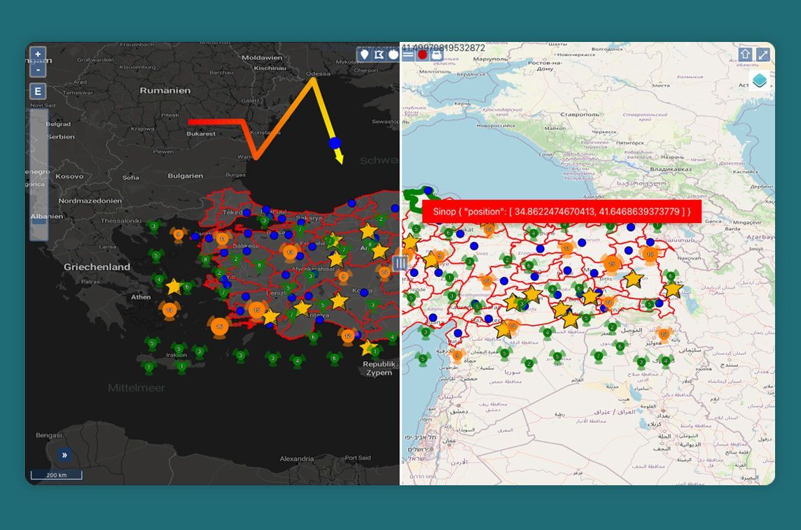
The migration from OpenLayers to MapLibre is progressing nicely. Full draw support is almost done. Even drawing across the dreaded anti-meridian works. That means I’ll finally be able to support Pacific Theater scenarios properly.
3
2
32
2,452

Apr 14
En este carrusel te explicamos cómo funciona el **clustering en OpenLayers** para agrupar entidades cercanas y mejorar la lectura del visor.
Leer más: geoinnova.org/blog-territori…
Formación relacionada: geoinnova.org/curso/desarrol…
1
3
185

¡ÚLTIMAS PLAZAS! Mañana comienza nuestro Curso Online de Desarrollo de Visores de Mapas Web.
Programación web para desarrollar aplicaciones web y publicar a través OpenLayers y Leaflet. ¡¡¡¡APÚNTATE YA!!!!
INFO Y MATRÍCULA:
forestales.net/contenidos/cu…

2
188

Apr 13
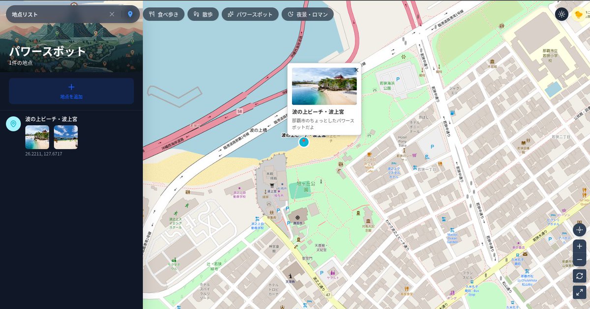
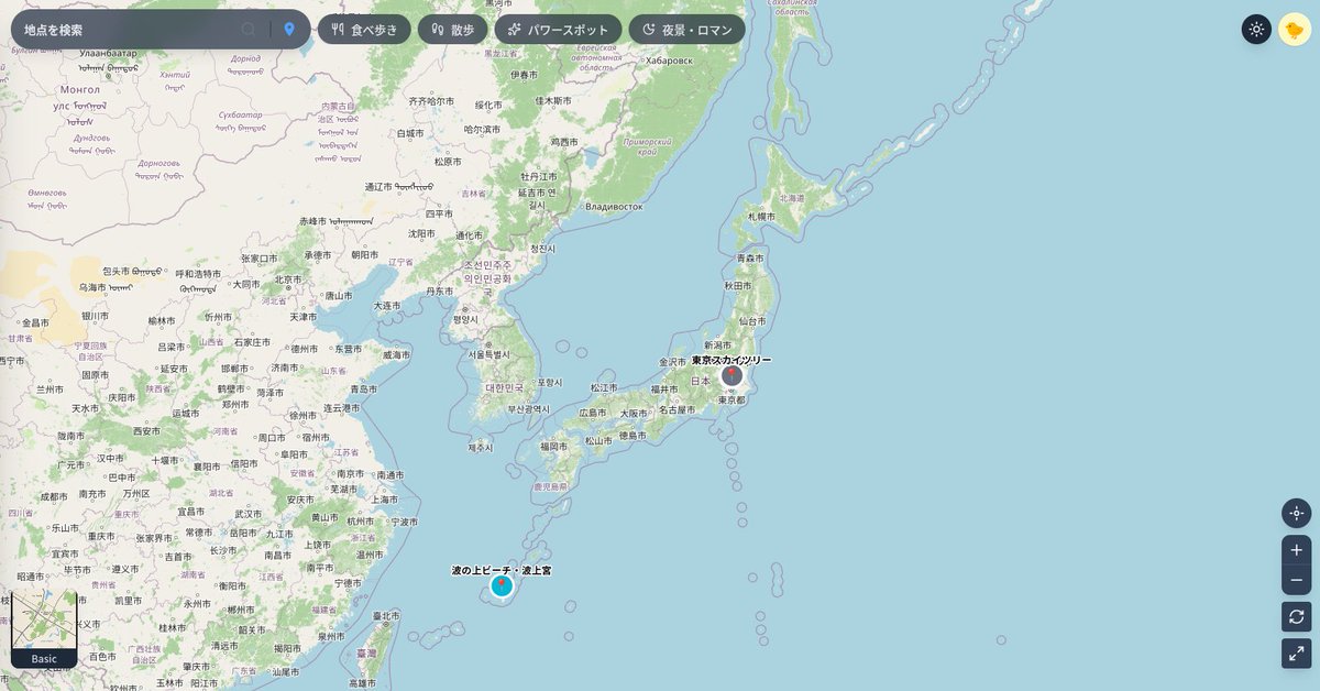
【SNSに地図と連携】
OpenStreetMap MapTilerの地図データをNext.js OpenLayersでGoogleマップさながらの操作感で編集できるように再現しました。
交換日記ミニSNSに、組み込んで「地図も共有」できるようにしてみた。これにより、たとえば、「食べ歩き」とか「パワースポット」とか地図でも楽しめる
1
29
1,594

Tom Cruising OpenLayers
No mouse. Just hands controlling the map.
Built this using MediaPipe
1
4
95

Mar 24
Display maps with tiled, raster or vector layers loaded from different sources with vue3-openlayers 🗺️ - madewithvuejs.com/vue3-openl…
1
4
557