
Mapping stuff on Earth with data from space @planet 🛰️🌍🗺️ #EarthObservation #GIS & #MachineLearning nerd
Joined December 2013
- Tweets 248
- Following 395
- Followers 172
- Likes 400
9 Photos and videos


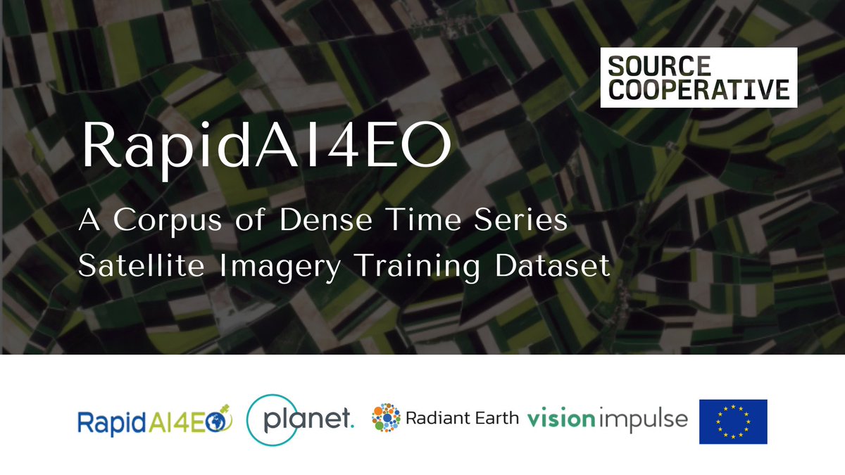
Today, through the #RapidAi4EO consortium, we released one of the largest Earth observation training datasets for #ML applications via @OurRadiantEarth.
The data covers 500,000 locations across Europe, captured every five days over two years. Learn more: go.planet.com/rapidai4eo
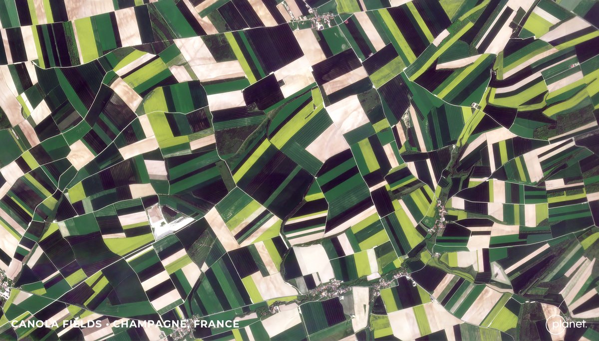
ALT PlanetScope - Champagne, France - May 4, 2023
1
16
59
17,095
Maddie Grady retweeted

17 May 2023
🆕Upgrade your #ML skills w/ #RapidAI4EO! This #TrainingDataset has 500K locs across Europe, Sentinel2 mosaics & cloud-free @Planet data. It’s the largest collection of multimodal time series satellite imagery for various applications.
🙏🏽 Funded by 🇪🇺
🔗 rapidai4eo.source.coop
31
87
20,767
Maddie Grady retweeted

11 Aug 2022
Crimea airbase badly damaged, satellite images show bbc.in/3dnn9Mg
50
88
433

Maddie Grady retweeted

9 Jun 2022
Today we are proud to announce Dynamic World, the first near real-time global 10m land cover dataset, with @WorldResources, to quantify planetary changes and take action. Powered by @Google #EarthEngine AI daily @ESA_EO Sentinel-2 data.
Learn more → blog.google/products/earth/d…
6
122
455
Maddie Grady retweeted

1 Jun 2022
Here we are! The official launch... welcome to a new community, associated with @SistersofSAR and @LadiesOfLandsat. It's just a one woman band at the moment, so please join, RT, DM and we can build this community together...
10
57
126

We are pleased to announce the release of RSGISLib V5, available on the conda-forge channel and at rsgislib.org
Release notes are here (github.com/remotesensinginfo…) but below is a 🧵 of the highlights:
#python #opensource #geospatial #remotesensing #GIS #EOchat
1
17
42
Maddie Grady retweeted

18 Dec 2021
Watch! @Forest_Research December seminar ‘The Use of Satellite Imagery in Forestry in Great Britain’ presented by Dr Maddie Grady and Dr Antony Walker, and hosted by Nicol Sinclairs ow.ly/ZoFe50Haup2 #forestryinnovation #satelliteimagery #forestimagery #forestresearch
2
3
Maddie Grady retweeted

21 Dec 2021
when you think about it, #gischat is also the Guardians of the Globe but, you know, with more supermapping and less superpowers #mappymeme
5
25
172
Maddie Grady retweeted

10 Jan 2022
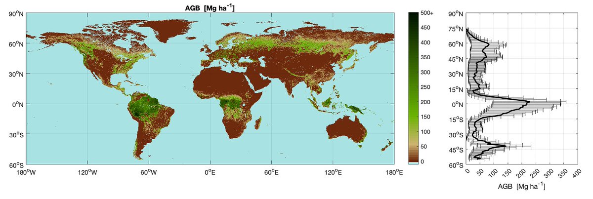
🗺️ Maps revealing areas of the world’s forests which have substantively changed over the past decade have been published through a @esa project that is managed and coordinated by @AberUni 🗺️ #climatechange
🖱️🗞️ Full story: bit.ly/3F5D224
18
30
Maddie Grady retweeted

17 Dec 2021
Just launched - a new app to aid mapping windblown impact of Storm Arwen. Read more on our website: forestresearch.gov.uk/news/n…
11
10
Maddie Grady retweeted

14 Dec 2021
(2) Staff in @scotforestry's GIS team have worked with @Forest_Research to produce an interactive mapping tool for woodland owners. It gives initial location on the damage via satellite information. Access it here: experience.arcgis.com/experi… #StormArwen forestry.gov.scot/news-relea…

1
11
25

14 Dec 2021
Interested in woodland loss, species mapping or remote sensing in forestry? Check out the recording of our seminar: A remotely sensible idea? The use of satellite imagery in forestry in Great Britain 👀🛰🌳 #forest #woodland #forestry #remotesensing #earthobservation #EO #trees
14 Dec 2021

Want to know more about the use of satellite imagery in forestry in Great Britain?
The recording of our Forest Science Seminar is now available vimeo.com/656160730

2
5
16
Maddie Grady retweeted

11 Dec 2021
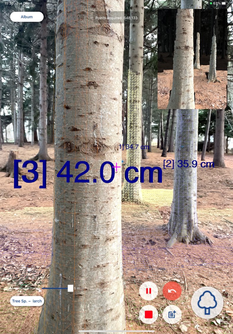
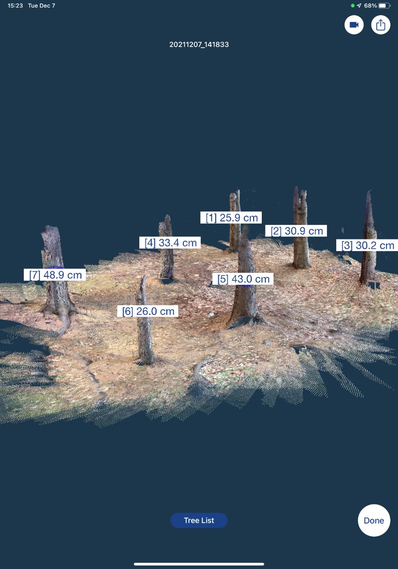
#ForestScanner RELEASED!
ForestScanner, an iPhone/iPad application for LiDAR-baed tree measurement, is now available at the App Store for FREE!
Developed in collaboration with @yamaguchi_mapry
16
211
654
Maddie Grady retweeted
7 Dec 2021
🎄🎄 COMING SOON 🎄🎄
ForestScanner -- an iPhone/iPad application that allows LiDAR-based tree measurement
89
668
2,996
Maddie Grady retweeted
18 Nov 2021
Want to know more about the use of satellite imagery in forestry in Great Britain? Join our online seminar on 10 December explaining how sensing technology is being used by foresters to understand woodland loss and to support tree health monitoring.
forestresearch.gov.uk/events…
11
17
8 Oct 2021
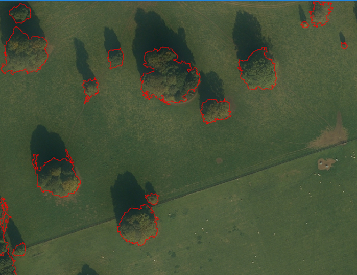
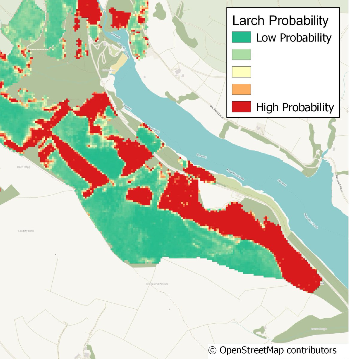
At the end of @WorldSpaceWeek and as one of the #WomenInSpace I wanted to shamelessly share some of my own work with #satellite and #earthobservation data. From segmentation and mapping down to an individual tree with @FR_LUES @FR_WoodCreation @Forest_Research and @watts_km...
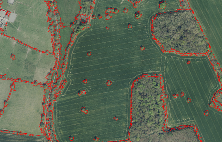

2
7
18
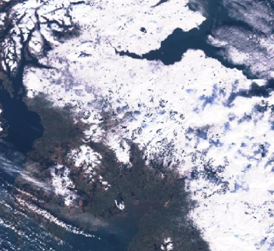
8 Oct 2021
...to my PhD research @AberUni @AU_EarthObs funded with @KESS_Aber developing automated land cover change detection approaches - the video is of forest loss and regrowth in central Wales between 1990 and 2017
1
1
9
8 Oct 2021
The data we get from satellites and earth observation both has and is changing the way we study and measure the Earth. The #spaceimpact is huge. 🛰🌍🗺#WorldSpaceWeek #WorldSpaceWeek2021
7