
22 Jul 2025
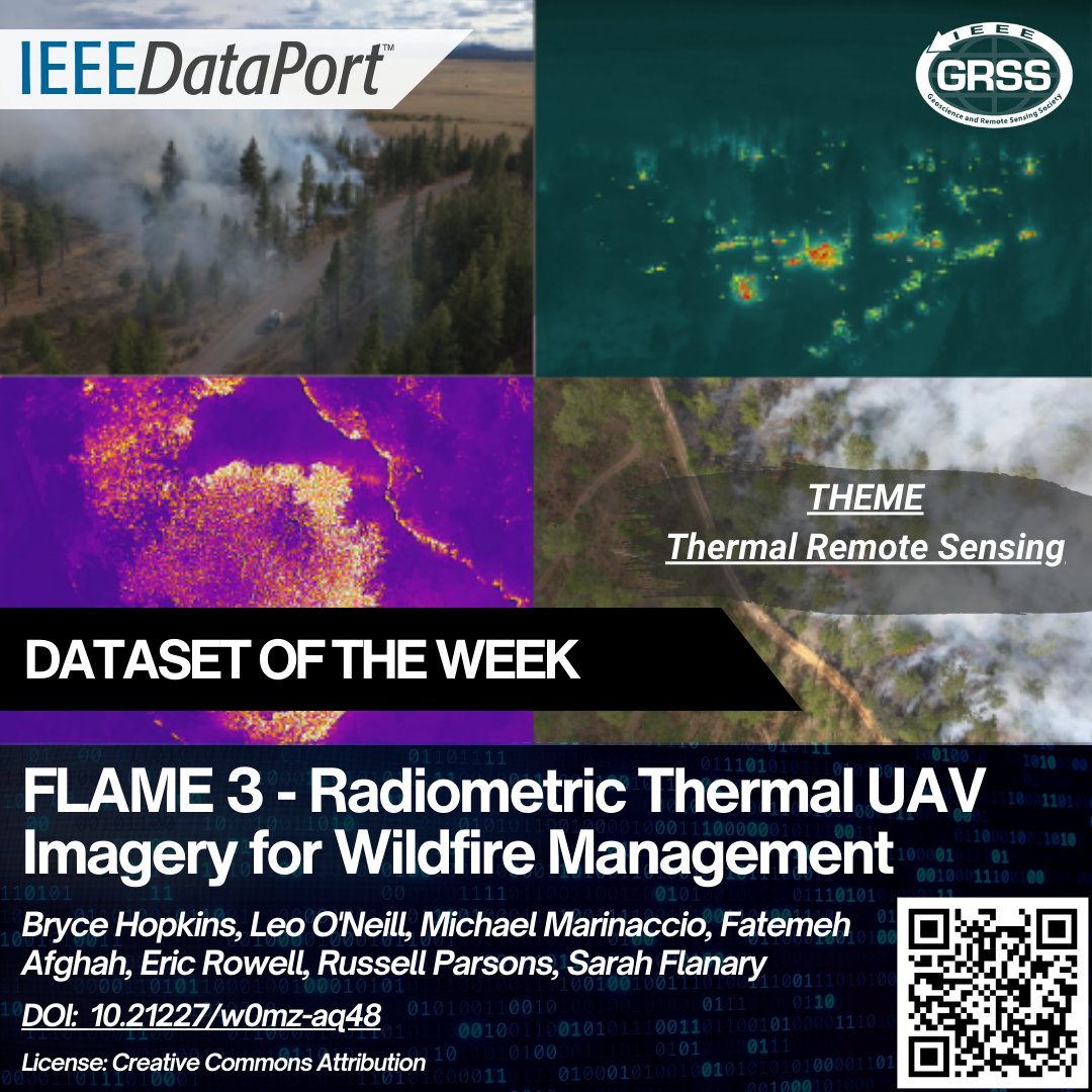
📢 Explore the FLAME 3 Wildland Fire Dataset – a UAV-collected, multi-spectral dataset for wildfire detection and segmentation
🔥 Captured over prescribed burns using RGB and thermal sensors
🖼️ Includes 738 image quartets (622 Fire, 116 No Fire), each with raw RGB, thermal, corrected FOV RGB, and thermal TIFF images
🎯 Designed for computer vision tasks like fire detection, segmentation, and change monitoring
🌐 Features georeferenced overhead thermal imagery (NADIR set) every 3–5 seconds for analyzing fire progression
🗺️ Includes pre, post, and during burn imagery with GCPs for centimeter-grade measurements
📄 More info: dx.doi.org/10.21227/w0mz-aq4…
#FLAME3 #WildfireDetection #ThermalImaging #UAVData #RemoteSensing #ComputerVision #FireMapping #OpenData #EnvironmentalMonitoring
2
181

6 Feb 2025
The MTBS @QGIS #FireMapping Tool has been updated! This #OpenSource tool, developed by EROS and the @ForestService GTAC, allows users to assess the impacts of fires before MTBS assessments are published. Download it here: ow.ly/hvLw50UUykJ
#FireScience #Landsat #Sentinel2

ALT Graphics from the MTBS QGIS Fire Mapping Tool User Guide. The top image shows a diagram of the process and formula for developing the Differenced Normalized Burn Ratio (dNBR), and the bottom image shows a screenshot of a post-fire Landsat image with the Band Rendering options in QGIS.
2
7
417

10 May 2024
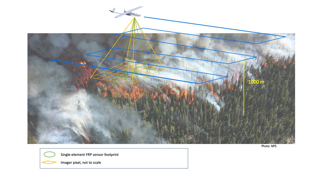
A Lightweight Remote Sensing Payload for Wildfire Detection and Fire Radiative Power Measurements
mdpi.com/1424-8220/23/7/3514
#Wildfires #FireRadiativePower #FireTemperature #FireMapping
87

7 Dec 2023
This is a story about wide-angle imaging for #firemapping and maritime search but it’s also a story about changing the culture and getting people to trust a new way of doing things.
mapscaping.com/podcast/fire-…
1
21
85
9,676

4 Sep 2023
Great work @OroraTech!😍
Love these, thanks for the late night tag!
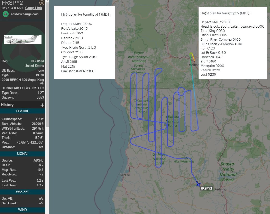
Comparing to the survey flight up; Part 1 is now complete & moving onto Part 2 for fresh am fire maps!
#ORfire #CAfire #firemapping

4 Sep 2023

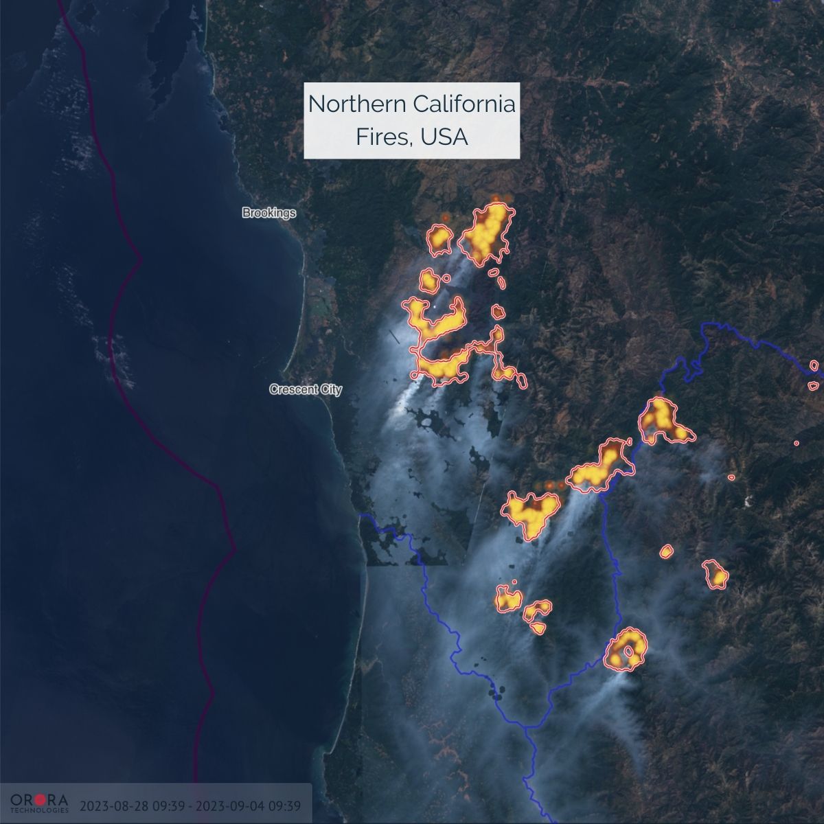
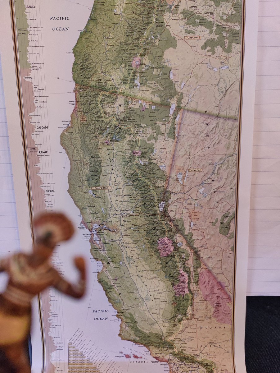
#Wildfires continue to rage in Northern #California, sparked by lightning strikes and fueled by recent hot weather. The largest, Smith River Complex fire, covers 83,000 acres (33,589 ha). Smoke has blanketed the Bay Area. Relief is expected soon due to the rain forecast. 🔥
1
1
3
469


5 Aug 2022
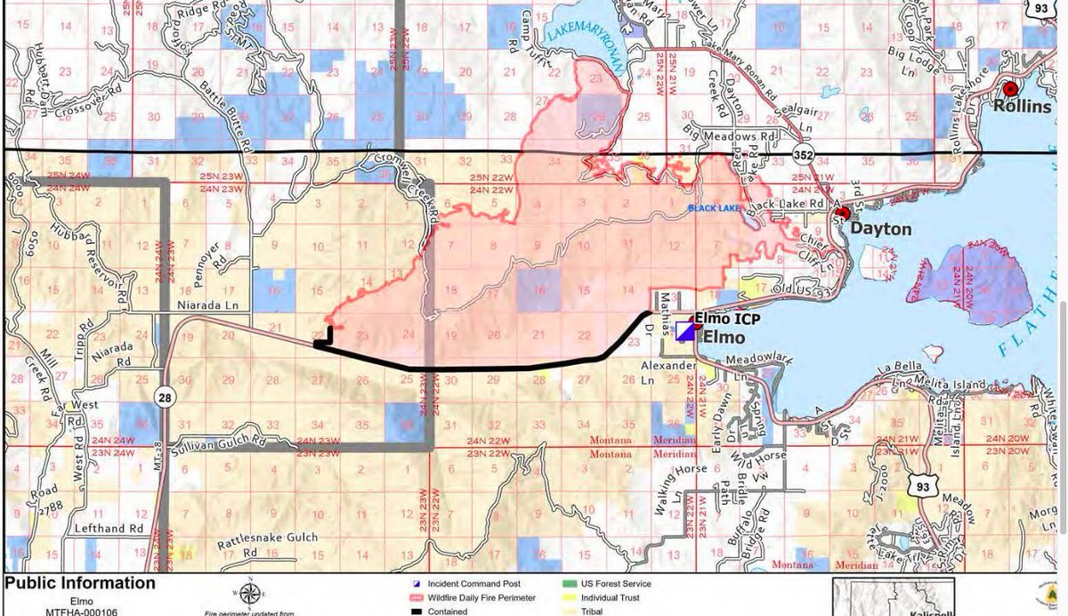
There is a meeting tonight at the Elmo Pow Wow Grounds at 7p.
Kinda of related— google maps does rough firemapping for incidents now but the emphasis is on ROUGH. "May vary by several miles" is the disclaimer. Look at fire maps on Inciweb for accurate perimeters.
1
1

29 Aug 2021
#CaldorFire #MultipleCounties #LakeTahoe #CA #NV #USA #FireWeather #FireMapping
Hoping all remaining in affected areas have firm #EvacuationPlans
readyforwildfire.org/prepare…
29 Aug 2021

Gotta say, the outlook for the #CaldorFire is not good. With fire established on both sides of 50 east of #Strawberry and crescendoing SW winds for the next 48 hrs (including at night) it is hard to imagine scenarios in which it doesn't make a run toward Hwy 89 south of #Meyers.

3

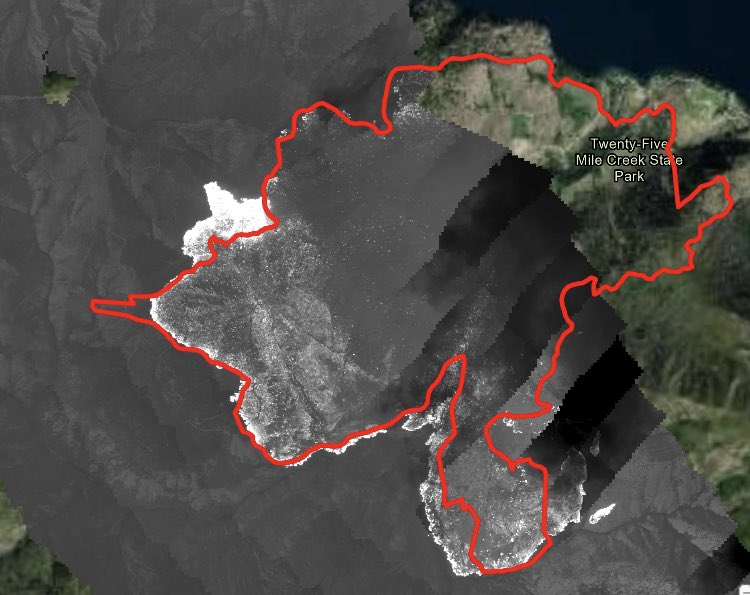
Great work by the crews hitting the 25 Mile Fire on lake Chelan. Looks like just a few hot spots left to mop up. #twentyfivemilefire #firemapping #firemapper #firemap @MtAdamsInf @waDNR_fire @BLMOregon

2
How technology in the air battles fires on the ground - BBC News #firemap #firemapping #firemapper @waDNR_fire @EWFIREANDHAZARD @wildfiretoday @BCWildfireHelp @wildfirenews bbc.com/news/av/world-us-can…
3
17 Aug 2021
WOW! 🔥🌋✈️
Awesome work @Coldsalt!
Check this out #firetwitter tech: @CAFireScanner @barkflight @ai6yrham @RobMayeda @US_Stormwatch @8bitmeme @mn_storm @BranomJaeden @JhawkFire
#wildfire #wildfiretech #aerialfirefighting #fireGIS
#firemapping #firemappers #firewx #cafire #cawx
1
2
Clouds stopped us from getting all of the #twentyfivemilefire. @waDNR_fire @MtAdamsInf @NWCCInfo #WAwildfire #firemapping #mappingfire
1
1

7 Jun 2021
Miss the premiere episode of #AdvancingAustralia?
Here’s a link to the episode as we discuss the use of aerial fire mapping technologies to combat bushfires in Australia: ecs.page.link/Tmqb8
#bushfire #firemapping #innovation
1
2
5 Jun 2021
Tune in to our TV debut tonight! In #AdvancingAustralia, hosted by the legendary @TheGuyPearce, we will be tackling the issue of wildfires with our innovative bushfire-mapping tech.
Tune in to @Channel10AU and 10 play at 6pm.
#bushfire #firemapping #innovation
1
4
3 Jun 2021
“Fires today are more intense, more widespread and more frequent. We now have fires that are becoming almost too big to fight.” Dr Paul Dare talks the need for new innovations and #firemapping like FireFlight in our TV debut for #AdvancingAustralia on @Channel10AU. #bushfires
3

3 May 2021
Getting ready to spin into Monday! The FVR-90 UAV is capable of staying aloft up to 13 hours! #keepingpeoplesafe
#aerialfirefighter #aerialfirefighting #L3Harris #fvr90 #uav #uas #drone #Carbonfiber #Wildfire #wildlandfire #surveillance #firemapping #situationalawareness
1
2
21 Mar 2021
Great view of a controlled burn in the Ngarkat Conservation Park last week.
#firemapping #controlledburn #prescribedburn

2
5

31 Aug 2020
Mapping and surveying the Cinnabar Fire. A Zoom Meeting allows fire Managers to view a live camera feed from the UAV!
#l3harris #fvr90 #firemapping #firefighting #aviation #UAS #UAV #drone #aerialfirefighting #wildlandfire #firefighters #Cinnabarfire #surveillance #realtime

2
3

25 Sep 2019
🛩🔥🚁 “This month the Orange County Fire Authority began a 150-day pilot program that could lead to real time fire mapping being available to firefighters on the ground.“ @OCFAChief #OCFA @PIOthanhn #wildfires #FireMapping #RemoteSensing
25 Sep 2019

Don’t Miss This => Orange County begins trial of real time mapping technology fireaviation.com/2019/09/24/… via @FireAviation #wildfires #firemapping #IRmapping #hightech @RSFireNerd @JohnAFisher @JhawkFire @Bewickwren @wildfirediva (Kudos to @FireAviation for sharing this great info.)
2
10