
Feb 12
$MVIS @MicroVision : 🚀 Innovative MicroVision Products for Security & Defense
MicroVision is bringing our cutting-edge solid-state lidar and real-time 3D perception technologies to mission-critical applications in the Security & Defense market. 📡✈️
Our lightweight, compact lidar solutions - designed to be mounted on drones and other autonomous platforms - were originally developed to advance autonomy, perception, and safety across automotive and industrial markets. We’ve tailored those solutions to support security and defense use cases such as ISR (Intelligence, Surveillance & Reconnaissance), terrain mapping, situational safety, and autonomous navigation in GNSS-denied environments. 🌍
MicroVision’s perception solutions deliver enhanced situational awareness and environmental understanding through precise 3D mapping - even in darkness, dense urban environments, and unknown terrain. Streamed to the ground in real time, they enable UAVs and connected units to see the world faster, more clearly, and with unprecedented precision.
👉 Learn more and stay tuned.
#MicroVision #lidar #ISR #RealTimeMapping #Innovation
youtu.be/L-zD4q8lJLg?si=0FZs…
2
19
385

22 Nov 2025
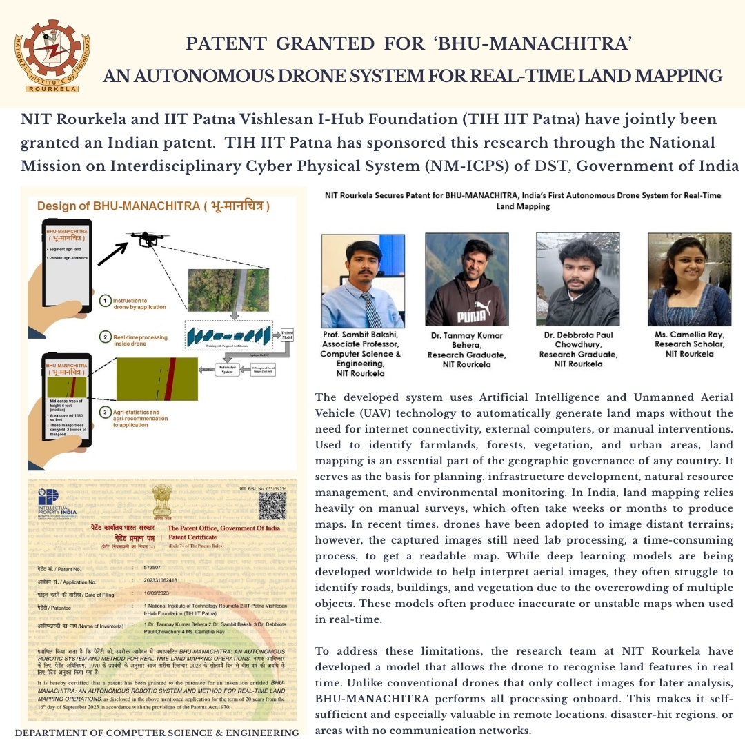
NIT Rourkela and TIH IIT Patna Secures Patent for BHU-MANACHITRA, India’s First Autonomous Drone System for Real-Time Land Mapping!
NIT Rourkela researchers have invented 'BHU-MANACHITRA', or earth map, an autonomous real-time land mapping drone system. The developed system uses Artificial Intelligence and Unmanned Aerial Vehicle (UAV) technology to automatically generate land maps without the need for internet connectivity, external computers, or manual interventions.
The research team comprises Prof. Sambit Bakshi (Associate Professor, Department of Computer Science & Engineering), along with research graduates Dr. Tanmay Kumar Behera, Dr. Debbrota Paul Chowdhury, and research scholar Ms. Camellia Ray from NIT Rourkela, invented this patented system (Patent No. 573507). IIT Patna Vishlesan I-Hub Foundation (TIH IIT Patna) Patna has sponsored this research through the National Mission on Interdisciplinary Cyber Physical System (NM-ICPS) of DST, Government of India. Unlike conventional drones that only collect images for later analysis, BHU-MANACHITRA performs all processing onboard. The invented methodology uses a lightweight AI model with as few as 2.48 million parameters, which makes BHU-MANACHITRA suitable for on-board processing in drones. This makes it self-sufficient and especially valuable in remote locations, disaster-hit regions, or areas with no communication networks.
With its potential use in a diverse range of sectors, BHU-MANACHITRA is expected to benefit multiple sectors, including government agencies involved in land record modernisation and urban planning, agriculture departments requiring real-time insights on crop and soil conditions, disaster management authorities needing immediate terrain assessments during floods or landslides, and environmental and forest departments responsible for monitoring deforestation, encroachments, and biodiversity changes.
Read more:
🗞️Education Times- Times of India: educationtimes.com/article/c…
🗞️Economic Times: economictimes.indiatimes.com…
🗞️The New Indian Express: newindianexpress.com/states/…
🗞️The Print Hindi: hindi.theprint.in/india/nit-…
🗞️Fortune India: fortuneindia.com/business-ne…
@EduMinOfIndia @IITPAT
#NITRourkela #IITPatna #TIHIITPatna #ComputerEngineering #ComputerScience #Patent #BHUMANACHITRA #DroneTechnology #ArtificialIntelligence #UAV #RealTimeMapping #Innovation #ResearchIndia #TechForSociety #DigitalMapping #MakeInIndia #RemoteSensing #DisasterResponse #AgriTech #SmartTechnology #ResearchAndDevelopment #EarthMapping
6
360

21 Jul 2025
Digital twin technology is revolutionizing highway management with real-time, map-based insight.
#DigitalTwin #HighwayManagement #SmartInfrastructure #NextGenMonitoring #GeospatialIntelligence #RealTimeMapping #ConnectedRoads #INTETRA
2
29

8 Apr 2025
प्रिय विद्यार्थियो,
.
इस क्विज़ में हम डेली की करेंट न्यूज़ के आधार पर आपसे प्रश्न पूछते हैं, इसका उत्तर आपको कमेंट बॉक्स में देना है।
.
#IITMadras #IndianInnovation #RealTimeMapping #MakeInIndia #ScienceAndTechnology #RecentNews #INNews #DailyCurrentAffairs #PCS #IAS #UPSC
1
12
435

14 May 2024
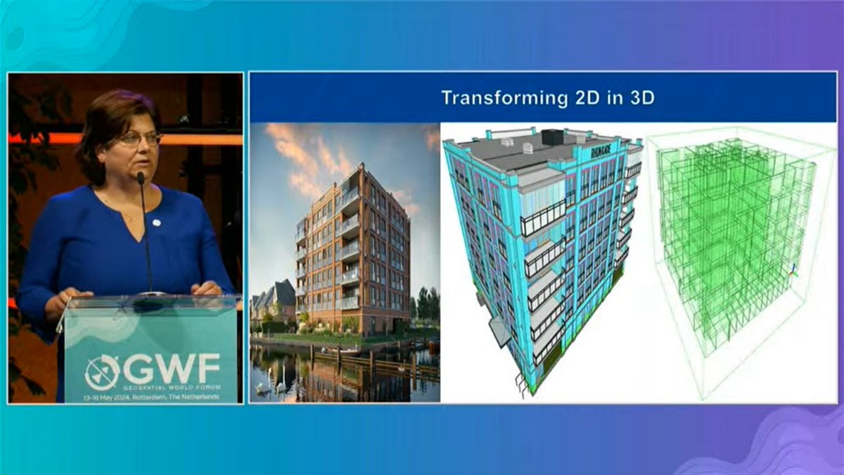
#GWF2024 | Cora Smelik, Board Member, Kadaster: These days, buildings are a lot more complex than they used to be.
They do not have just roofs, but various layers between the false ceiling and the roof, like insulation panels, electricity wires, etc.
So when we register a building after it is built and up for sale, we need all the information to inspect the house before registering it.
As compared to 2D models, the 3D models have more information about these layers. We want all the information starting from development phase. So now we draw all the information from the 3D BIM model and put it on the 2D model for the administration and other stakeholders.
#GWF2024 #GeospatialTransition #WorldEconomy #DataSolutions #RealTimeData #RealTimeMapping #BigData #DigitalTwin #DigitalTwins #AEC #DiverseDataSources #Cloud #CloudTechnology #3D #3DVisualisation #AI #ML #AIData
2
330

3 Apr 2024
Esri Products | ArcGIS Enterprise | ArcGIS GeoEvent Server
Explore more: esri.com/en-us/arcgis/produc…
#Esri #EsriSaudiArabia #ArcGISEnterprise #GIS #EnterpriseGIS #ArcGISGeoEventServer #RealTimeMapping #Analytics #IoT #GIS #SituationalAwareness #AssetTracking #SensorMonitoring
1
3
253

11 Nov 2021
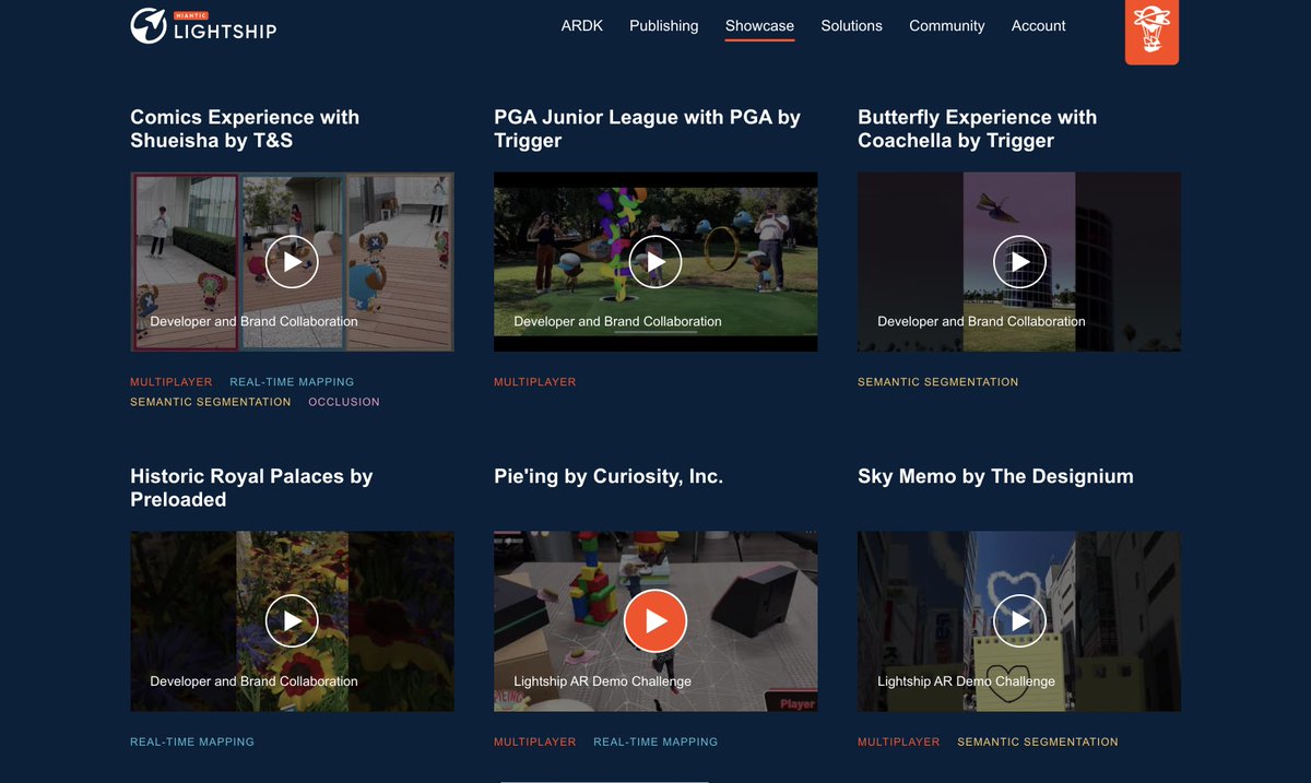
Our AR game "Pieing" is also introduced as a showcase!
lightship.dev/showcase/
#Niantic #Lightship #ARDK #Realtimemapping #Multiplayer
4

6 Jul 2021
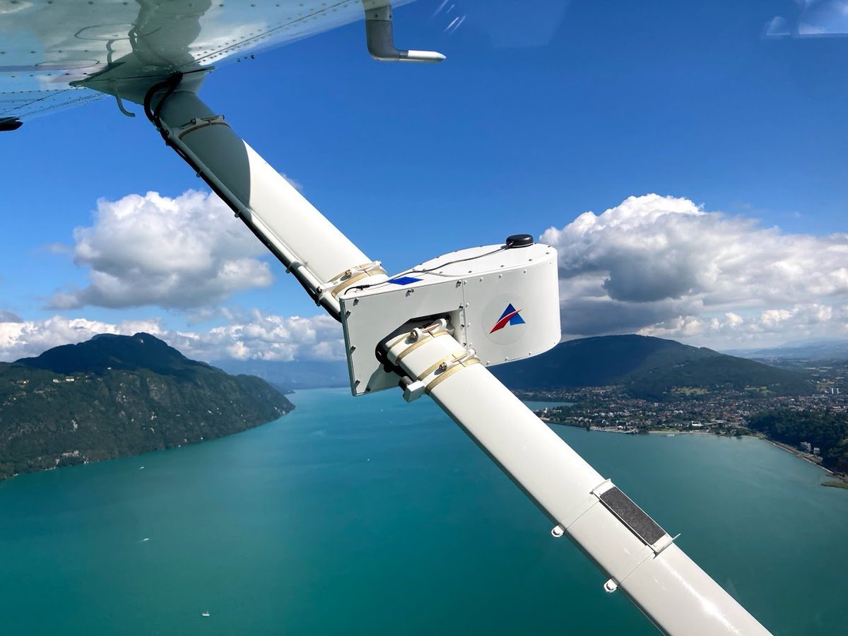
InstiMaps™ delivers georectified #multispectral #imagery in near real-time from manned & unmanned aircraft. Pictured is the InstiMaps #payload on a conventional aircraft, mapping #oil #pipelines in #France !
#aviation #mapping #realtimemapping #future #safety
1

6 Aug 2019
AR (Augmented Reality) just got realistic!!! 😆. Good stuff by @6d_ai. Looking forward to seeing how I can integrate it in my projects. 👌🏼 #madewithunity #6dai #realtimemapping #unity3d #occlusion #AugmentedReality
4

6 Feb 2018
En Amsterdam #ISE2018 inspirándonos para nuestros próximos eventos!! #realtimemapping @Dataton @bmotionav
7
11

15 Jul 2017
la mia intervista a @nobumichi_asai annamonteverdi.it/digital/th… @igitalart @AlmaArtis #realtimemapping #videomapping @JoanieLemercier
2
1

29 Dec 2016
@mikefarrell Expertise in #RealTimeMapping #LearningManagementSystem #LocationBasedServices. #RTM #LMS #LBS #AR
empressem.net

22 Nov 2016
@uber_schweiz Upcoming Popularity of #RealTimeMapping empressem.net/blog/upcoming-… #realtimemapping #spatialdata #mobileapp
1