
17 Dec 2025
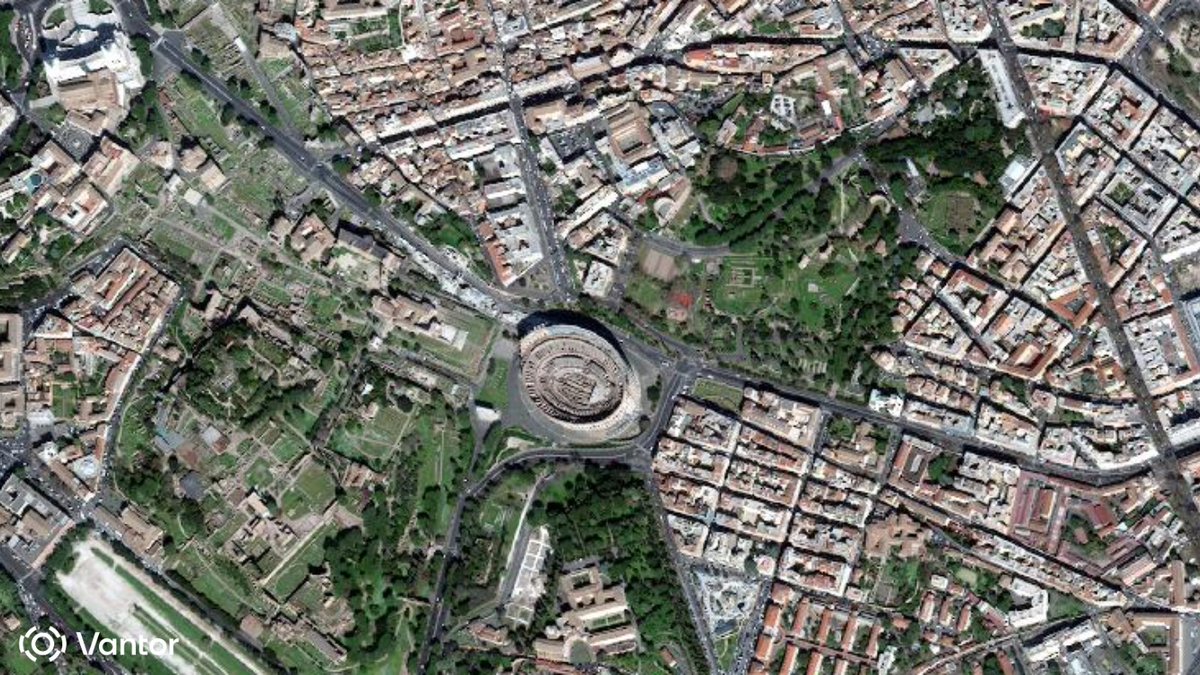
🎁Give yourself the gift of premium imagery from @vantortech, now available at SkyWatch-exclusive prices.
Limited-time offer ends Dec 31, 2025.
👉 hubs.li/Q03Yv2xt0
#satelliteimagery #satellitedata #basemaps #elevationdata #vantor
1
1
1
171

27 Jun 2025
The National Institute for Geo-Informatics Science and Technology, Survey of India, organised a two-day workshop from 18th to 19th June 2025 at the Survey of India premises in Hyderabad. The workshop focused on key aspects of planning, data acquisition, processing, delivery, QA/QC workflows, and process standardisation under the NAKSHA Project.
With participation from over 30 officers representing Survey of India’s Geospatial Directorates, Zonal Offices, the Office of the Surveyor General and private geospatial partners, the sessions facilitated collaborative knowledge exchange through presentations, demonstrations, and hands-on QA/QC activities.
The workshop underscored the importance of accuracy, standardized workflows and inter-agency coordination in delivering quality geospatial outputs. The NAKSHA Programme, delivered through a robust public-private partnership model, involves Map-1 activities such as the generation of True Ortho Rectified Imagery, Elevation Datasets (DSM, DEM/DTM), 2D/3D vector datasets, and 3D Mesh/Reality Models by leading firms including ARVEE Associates, Garuda UAV Soft Solutions, LTI Mindtree, and Arahas Technologies.
@DrJitendraSingh @karandi65 @IndiaDST
#SurveyofIndia #NAKSHAProject #GeospatialWorkshop #GeospatialData #MapDeliverables #ElevationData #3DMapping #GeospatialInfrastructure #UrbanMapping
1
5
274

17 Jun 2025
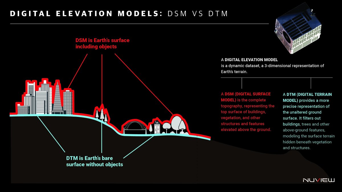
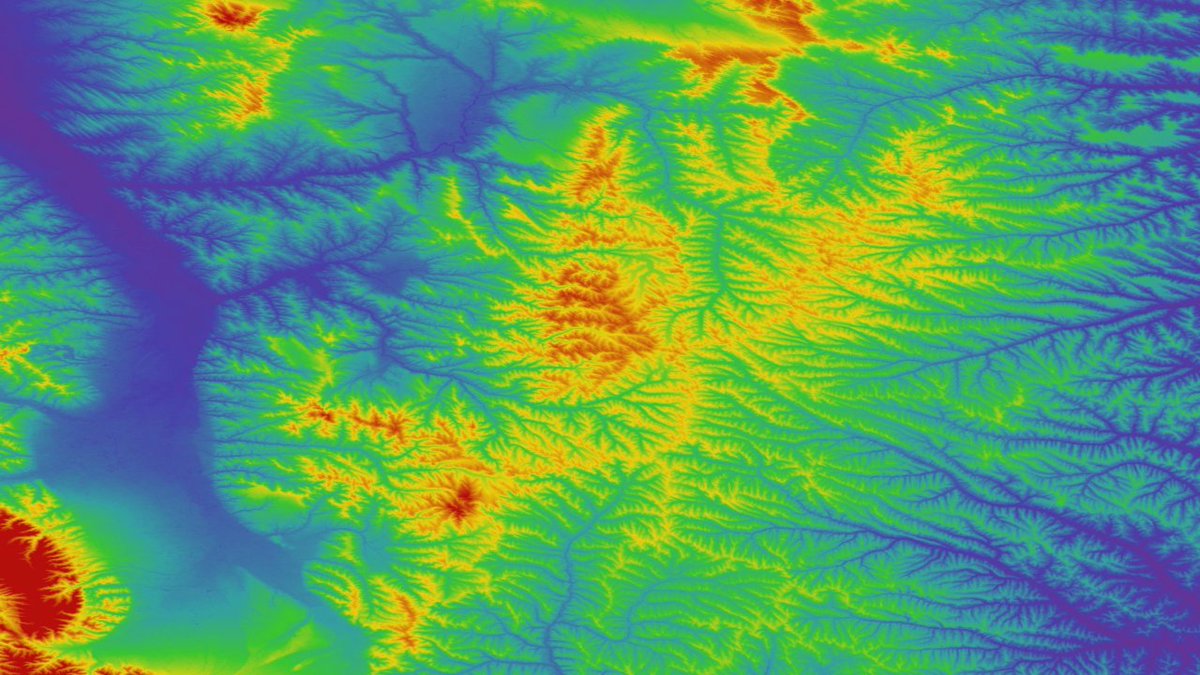
We’re building the most accurate global #DigitalElevationModel that has ever existed because #infrastructure, #climate modeling, and #nationalsecurity all depend on knowing not just where things are, but what lies beneath them. A #DSM gives us the top layer like structures, trees, or buildings, but for precision planning you need the #DTM - the raw terrain, unfiltered. We’re solving a high-friction problem: outdated, incomplete #ElevationData that hinders billions in global planning decisions. By combining space-based #LiDAR with scalable processing, we’re delivering ground truth at continental scale and at the cadence and clarity the world now requires.
#DEM #DTMvsDSM #NUVIEW #EarthObservation #NUVIEWplatform #GeospatialTech
1
2
162

24 Feb 2025
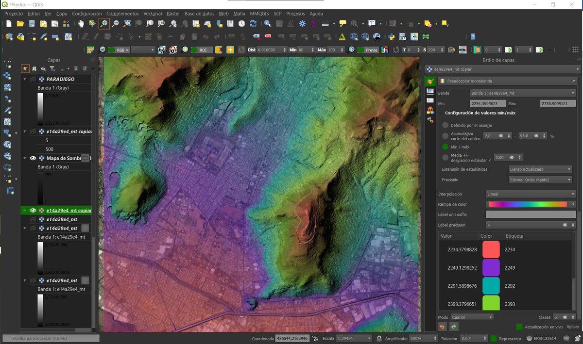
Quickly Download SRTM DEM Data for Any Study Area Using QGIS
Tutorial link: youtu.be/RjApJy5BaUw
#SEO #QGIS #SRTM #DEM #RemoteSensing #GIS #Geospatial #Topography #ElevationData #Mapping #SpatialAnalysis #TerrainModeling #DigitalElevationModel #Geoinformatics
23
70
2,825

16 Jan 2025
Join us at @AMEroundup Booth 1000 to explore how #SatelliteImagery and #ElevationData can support your #MineralExploration and #Mining goals and keep your projects moving forward. 🌍 🛰️

2
1
34

16 Nov 2023
🌏 New ArcGIS Living Atlas updates (Oct 2023) include:
High-resolution elevation 🏔 data for France, Nebraska, Italy, and beyond, a new feet measurement 📏 raster function, and more.
🔗 See details: esri.social/EMT050Q8v4W
#GIS #ElevationData #geospatial
1
1
414

[FAQ] Where can I get global elevation data? ow.ly/6nKp50PQUjp
#ElevationData🌎🗺️
ALT Map showing global GMTED2010 data coverage.
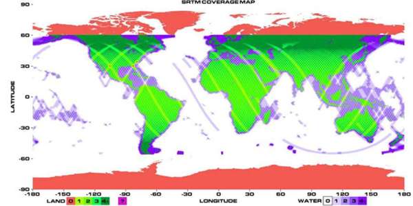
ALT Map showing Shuttle Radar Topography Mission (SRTM) data coverage.
ALT Terra ASTER Global Digital Elevation Model (GDEM) DEM data from the ASTGTM product over northern China between March 1, 2000 and November 30, 2013.
1
3
22
9,616

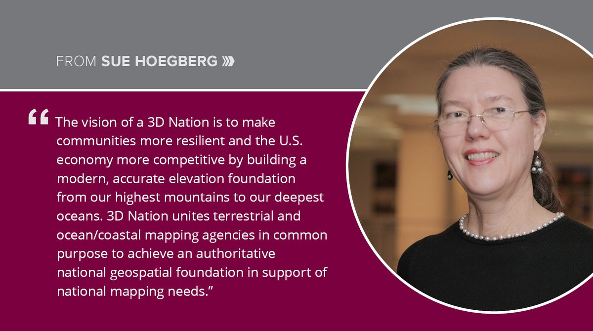
23 Mar 2023
Sue Hoegberg describes how the 3D Nation #ElevationData program could generate $13.5 billion in benefits by helping federal agencies such as @NOAA and @USGS better prioritize and direct investment dollars to address user and community needs. Check it out: dewberry.com/insights-news/p…
125

7 Nov 2022
2

25 Apr 2022
Created this amazing relative elevation model (REM) of the Santee River as it branches off of Lake Marion. This was inspired by @geo_coe and created in @qgis using one-meter @usgs 3DEP digital elevation models. #qgis #gischat #cartography #elevationdata #southcarolina #3dep #dem
4

14 Apr 2022
Thank you @NewOnGISCafe for the interview of Marie-Pierre Boutin, Sales & Marketing Director at @PlanetObserver_ on the latest release of PlanetSAT global imagery #basemap and PlanetDEM elevation dataset😀
Check it out here: giscafe.com/video/PlanetObse…
#GISdata #elevationdata #GIS
1
1
10 Mar 2022
Take a look at the huge difference between #PlanetDEM and AW3D30. Be aware of the limited quality of open-source DEMs.
PlanetObserver's goal is to make #ElevationDATA more reliable for your projects by correcting artefacts.
How many differences can you find?
#GIS #Geospatial
2
2
18 Jan 2022
Completely realistic 3D data sets lead to a visually stunning solution for the end-user.
Check out how we were able to help @FlightPath3D and @MetraWeatherUK get an incredible UX!
planetobserver.com/world-map…
#ElevationData #Geospatial #SatelliteImagery #Maps #MovingMaps

1
6
7
16 Nov 2021
PlanetObserver is proud to announce its latest global elevation solution: #PlanetDEM. A medium-resolution Digital Surface Model adequate for both civil and military applications.
Find out more:
planetobserver.com/global-el…
#ElevationData #Geospatial #GIS #GISApplication #PlanetDEM
5
4

Check out our CEO discussing Intermap's next-generation 3D GEOINT solutions. @NewOnGISCafe #GEOINT #Mapping #GeospatialData #ElevationData
www10.giscafe.com/blogs/giss…
3

11 Oct 2021
Imagen construida a partir de datos LiDAR y GoogleMaps del Cerro del Chiqihuite.
#digital #software #tecnología #DEM #SpatialAnalyst #MDE #geodata #Elevationdata
4

27 Sep 2021
We have big news to share! 🎉 We're excited to announce our newest program, #MetroHD city data, which delivers ultra-high-resolution 2D & #3D digital twins of global cities on demand. Learn more at hxgn.biz/3nNYBzc
#hxgncontent #aerialimagery #elevationdata @HxGNContent
2
5

21 Jul 2021
4

1 Jul 2021
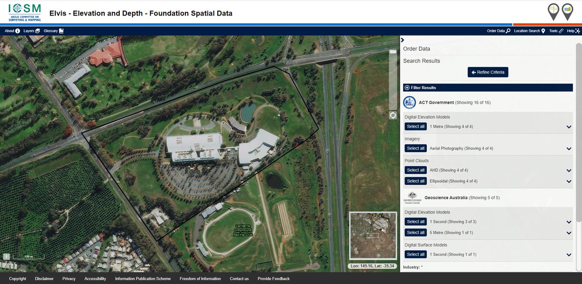
The Elvis Elevation & Depth (elevation.fsdf.org.au/) has changed recently.
We have released a new front end interface based on feedback in our last survey which includes a number of improvements
•New Search which includes an address search
•New Tools
#FSDF #ElevationData
1
2
4

21 May 2021
This article outlines the common sources of elevation data, including space-based radar, and helps to categorize the data quality and accuracy.
#GIS #ElevationData #Mapping #Data #Geospatial #3D #Lidar t.her.is/3c2G5fV
2
2