
Jun 7
What's one GIS skill you wish you learned earlier?
For me it's automating repetitive tasks with Python. Spent way too long doing things manually😂😂.
Drop yours 👇
#GIS #RemoteSensing #GeospatialMapping #QGIS
1
2
6
161

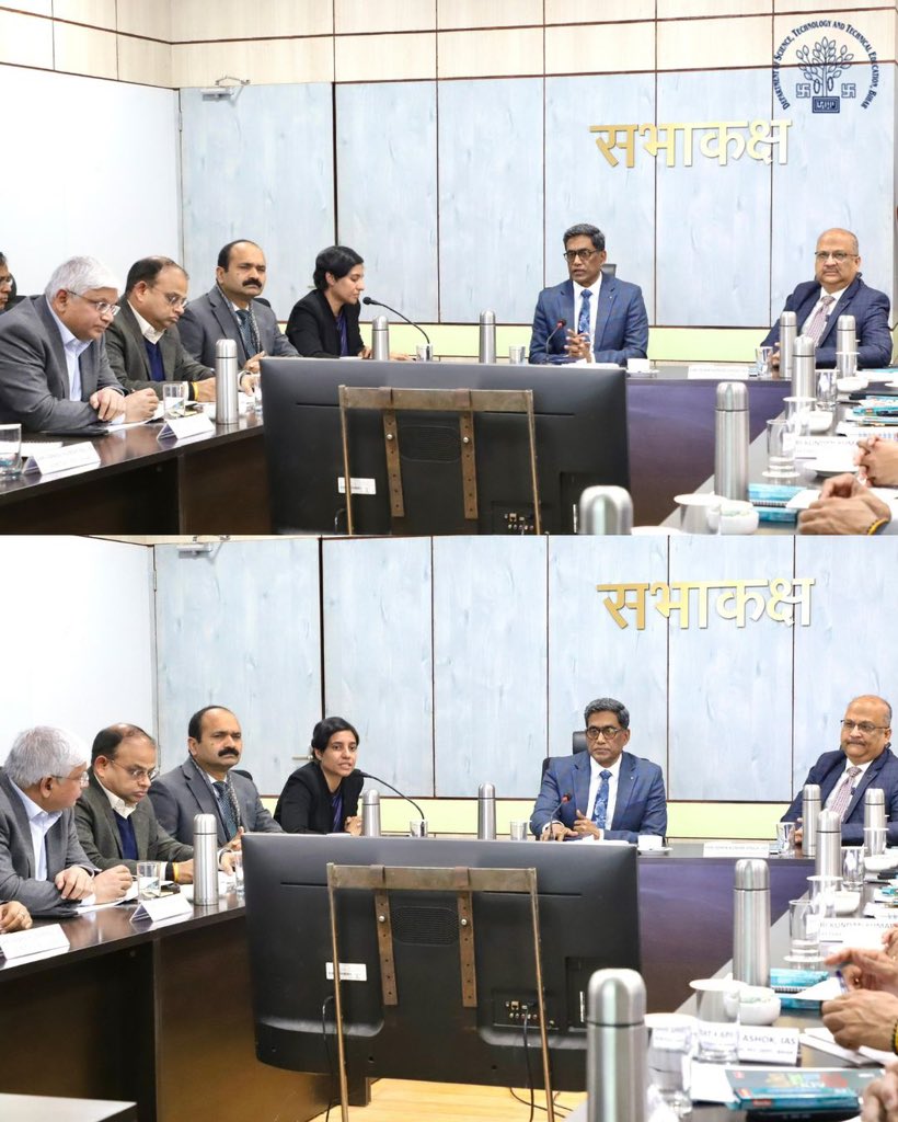
Jan 14
BIRSAC review meeting chaired by Chief Secretary Pratyaya Amrit focused on geospatial mapping and disaster monitoring in Bihar.
#BIRSAC #GeoSpatialMapping #DisasterMonitoring #DstteBihar
@IPRDBihar @BiharEducation_ @NitishKumar
3
148

3 Nov 2025
Another map made with Cadence for Day 3 of the #30daymapchallenge.
This was created by Rifat Foysal. Check out his full map explanation: linkedin.com/feed/update/urn…
#CadenceGIS #Cadence #geospatialmapping


1
6
182

$UAVS announces the launch of the MicaSense™ RedEdge-P™ Triple sensor package, a groundbreaking system that establishes a new standard for capability in precision #agriculture, #environmental monitoring, and #geospatialmapping
Read more: bit.ly/3Wdh9cb
#Drones #Drone

1
5
18
1,939

When heat tells a story, our thermal drones listen. 🚁
🔥 The Parrot ANAFI USA is redefining infrastructure inspections in Nigeria from power lines to search & rescue.
👉 Available now at Geoinfostore.com
#ThermalDroneNigeria #DroneInspectionLagos #GeospatialMapping
1
3
4
1,080

27 Jul 2025
If you have experience in one of the roles above, please consider signing up via our volunteer form on our website: electiontruthalliance.org/jo…
Thank you!
#Volunteer #Democracy #Recruitment #Nonprofit #VRM #GIS #GeoSpatialMapping #DataReporting #DataReports #Paralegal
1
8
403

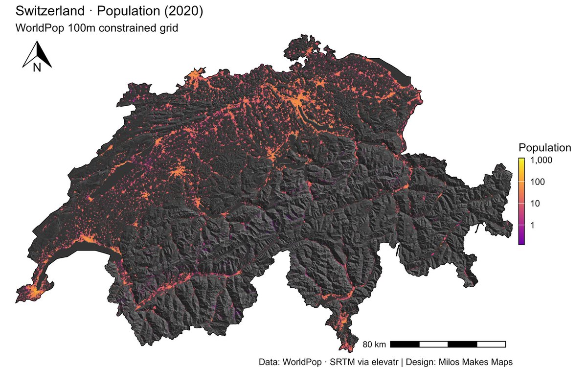
8 Jun 2025
8 Jun 2025

Want the secret to stunning maps like this Switzerland hillshade & population visualization?
My latest YouTube tutorial shows you exactly how!
🎬 Watch here 👉🏻 youtu.be/2dNIultQQ4Y
#GIS #Cartography #RStats #DataViz #MilosMakesMaps
2
4
1,474

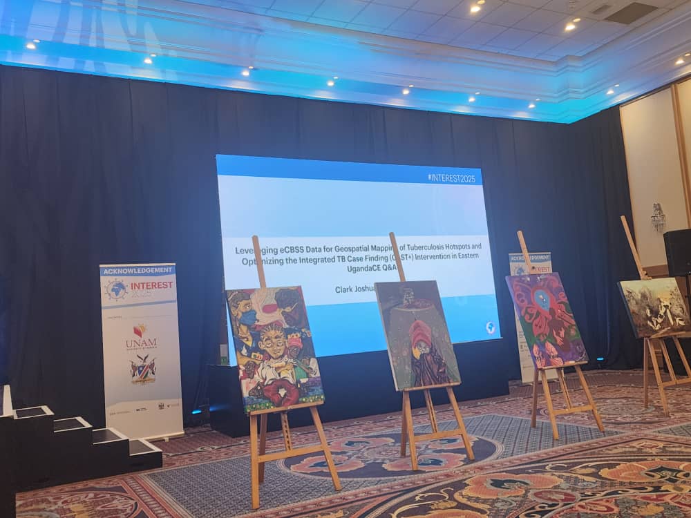
16 May 2025
INTEREST 2025 Conference Update!
We’re thrilled to share that Clark Joshua Brianwong of Baylor Foundation Uganda has been honored with not one, but two prestigious awards at this year’s conference:
1. The Charles Boucher Award
2. Best Oral Presentation Award
Congratulations, Joshua!
#INTEREST2025 #BaylorFoundationUganda #PublicHealthInnovation #TBResponse #GeospatialMapping #DigitalHealth #AwardWinning #DataForImpact
@DKiragga, @TexasChildrens, @sidneyakuma, @MinofHealthUG

3
4
18
613

17 Feb 2025
माननीय प्रधानमंत्री श्री @narendramodi जी के #DigitalIndia मिशन को नई गति!
सोनपुर अब #NAKSHA परियोजना के तहत शहरी भूमि रिकॉर्ड के डिजिटलीकरण की ऐतिहासिक पहल में शामिल। ड्रोन व एरियल मैपिंग से पारदर्शिता और भूमि विवादों का होगा समाधान।
संबंधित समाचार आज के अखबारों में...
#GeospatialMapping #NewIndia #Bihar #LandReforms #Sonpur #BiharDevelopment #DigitalLandRecords
@ChouhanShivraj @OfficeofSSC
@BJP4India @BJP4Bihar @BJP4Chapra
5
6
56
1,266

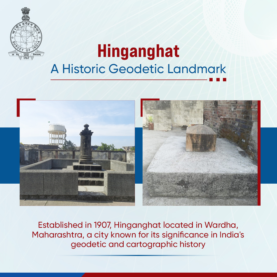
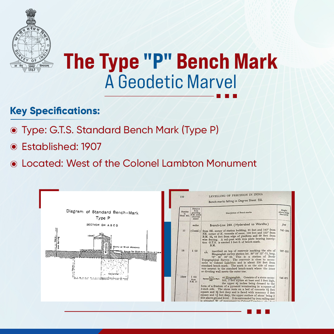
10 Feb 2025
Hinganghat’s Type "P" Bench Mark is a significant geodetic reference point, reinforcing India’s surveying and mapping precision for over a century. Established in 1907, this G.T.S. Standard Bench Mark (Type P).
Enclosed by an iron railing, it remains an essential marker for geodetic control, cadastral mapping, and infrastructure development. This benchmark plays a vital role in high-precision land surveys, supporting accurate boundary demarcations, land resource management, and geospatial applications. It provides critical elevation data used in urban planning, disaster management, and geographic studies, ensuring reliable reference points for national development initiatives.
By linking historical surveying methods with modern geospatial technologies, Hinganghat’s benchmark continues to uphold India’s mapping legacy and geodetic excellence.
@DrJitendraSingh @karandi65 @IndiaDST
#SurveyOfIndia #GeodeticControl #NationalSurveying #MappingIndia #ColonelLambton #GeospatialMapping
1
5
5
392

9 Feb 2025
✨ Perfectly stitched 3D model of a rural neighborhood, reconstructed from high-resolution drone images taken by DJI ZENMUSE p1, using #DroneDeploy. This 3D orthomosaic is a high-resolution, distortion-free map, created by seamlessly combining multiple images.📡#GeospatialMapping
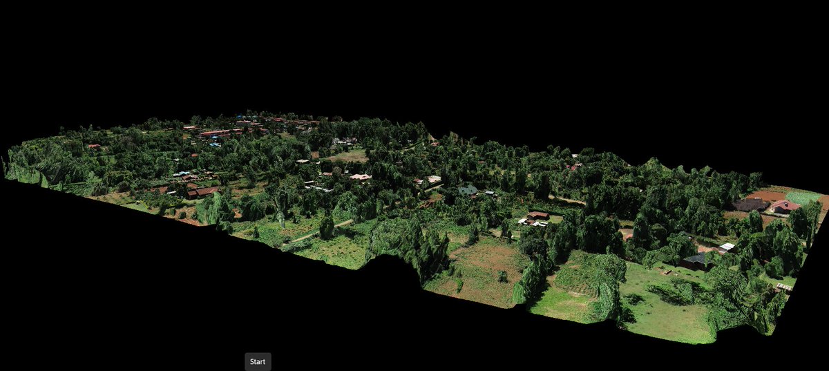
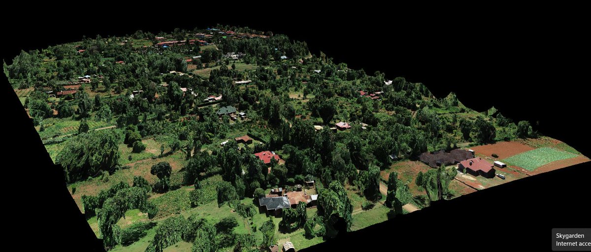
6
22
812

22 Jan 2025
Mapping the future of intermodal freight transport - where drones, AI, and real-time data converge to optimize the flow of goods across land, air, and sea.
#IntermodalTransportation #GeospatialMapping #SupplyChainLogistics #DroneDelivery #AI4Logistics
2
2
28
30 Dec 2024
Survey of India takes pride in being at the forefront of the SVAMITVA (Survey of Villages and Mapping with Improvised Technology in Village Areas) scheme, a Central Sector Scheme, as a technical partner to the Ministry of Panchayati Raj.
This pioneering initiative aims to revolutionise rural governance and empower communities. By harnessing advanced drone technology, the scheme provides precise property ownership records, enabling transparent land management and fostering sustainable development in rural areas.
Through SVAMITVA, over 400 drones have been deployed by the Survey of India to conduct high-precision surveys across the country. These efforts have resulted in the capture of more than 160 million aerial images, facilitating the accurate mapping of 300,000 villages. Additionally, the scheme has generated over 4 PB of geospatial data, creating a comprehensive foundation for rural development and infrastructure planning.
The initiative delivers significant benefits to rural citizens. It provides property ownership cards, strengthening individual rights and reducing land disputes. Documented ownership also improves access to financial services, such as loans, driving economic empowerment. Furthermore, the precise mapping of village boundaries facilitates better land-use planning, while enhanced transparency ensures more effective decision-making at the local level.
The SVAMITVA scheme exemplifies a transformative approach to rural development, aligning with the Government of India’s vision for inclusive and equitable growth. By integrating innovation with geospatial technology, this initiative empowers rural communities and paves the way for a more prosperous future.
@DrJitendraSingh @karandi65 @IndiaDST
#SurveyOfIndia #SVAMITVA #DroneTechnology #RuralDevelopment #GeospatialMapping #GoodGovernance

4
140

22 Dec 2024
HM Shah stresses on mapping of demographic data of people along India-Myanmar border yespunjab.com/?p=74781
#AmitShah #IndiaMyanmarBorder #NortheastIndia #BorderSecurity #SpaceTechnology #NESAC #ISRO #NortheastDevelopment #GeospatialMapping #BorderFencing #EnvironmentalMapping #MineralMapping #FloodMapping #SpaceApplications #NortheasternStates #HomeMinister
54
21 Jun 2024
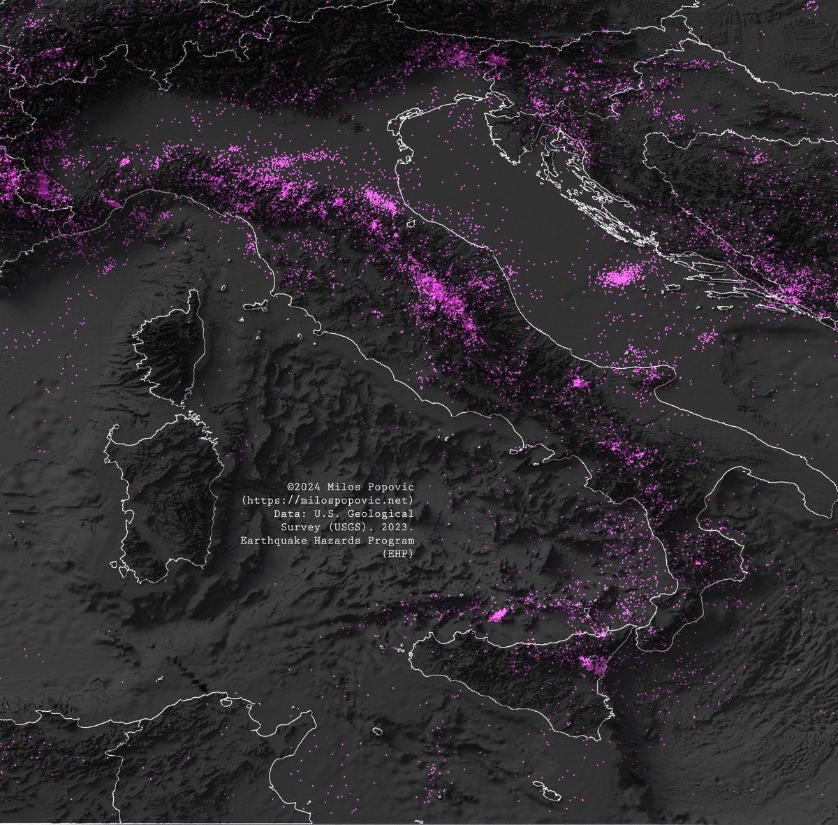
21 Jun 2024
My new map shows the seismic landscape of Italy and its environs, with over 16,000 earthquakes, each with a magnitude surpassing 2.5, from 1923 to 2023. 🌋
Can you spot the hotspots? 📍
Discover how to map earthquakes with my video tutorial. Click here: youtu.be/olNYYynSJfI
1
5
1,982
20 Jun 2024
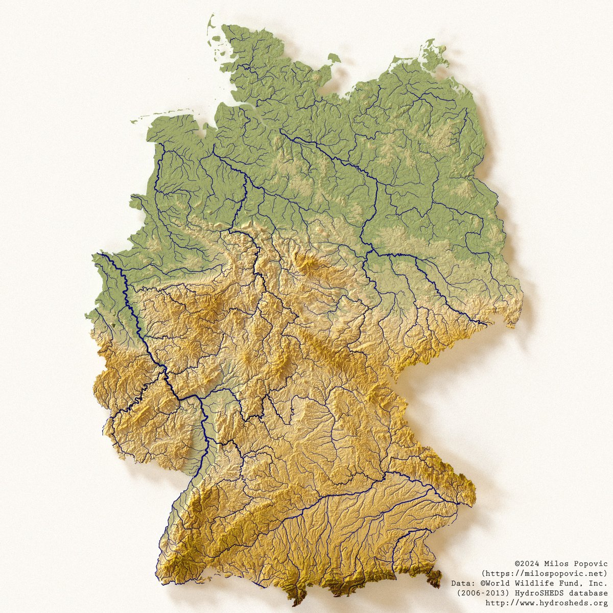
20 Jun 2024
Excited to share my new 3D elevation map of Germany, with scaled river systems.
Visual learners, rejoice! I've put together a YouTube video that takes you through the process of crafting 3D elevation maps and scaling rivers. Access it here:
youtu.be/piswxAEwnYo
2
3
1,446

12 Feb 2024
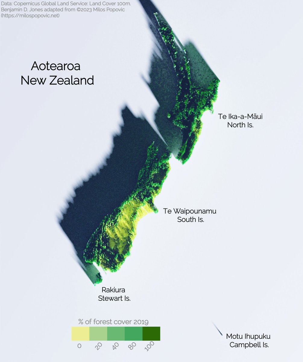
Copernicus 100m 2019 3-D forest cover map of Aotearoa / New Zealand. Inspiration from Milos Popovic, PhD "3D map with rayshader and ggplot2 in R" tutorial on youtube.
#DataVisualization #RProgramming #R #SpatialAnalysis #GeospatialMapping #3DMapping #DataScience
1
10
364
3 Jan 2024
3 Jan 2024
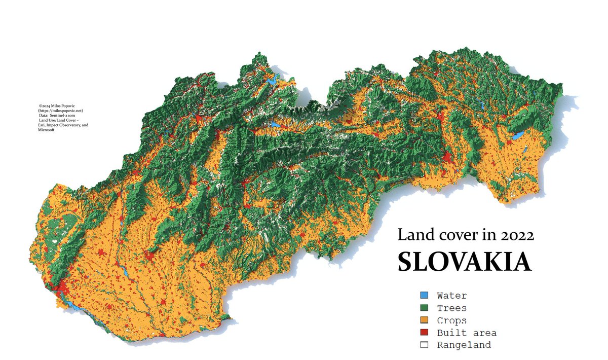
👇🏻Behold my new 3D map of Slovakia's land cover! 🇸🇰
Can you spot the mountains, forests, rivers, and cities? 🗺️
Want to make your own 3D map of any country? Watch my tutorial here: lnkd.in/eS_bJJps
RT and show me your maps! 🚀
#slovakia #nature #dataviz #map #art #R #datascience #education #geography #gis #cartography #spatial #environment #forest #visualart
1
6
1,536
28 Dec 2023
28 Dec 2023
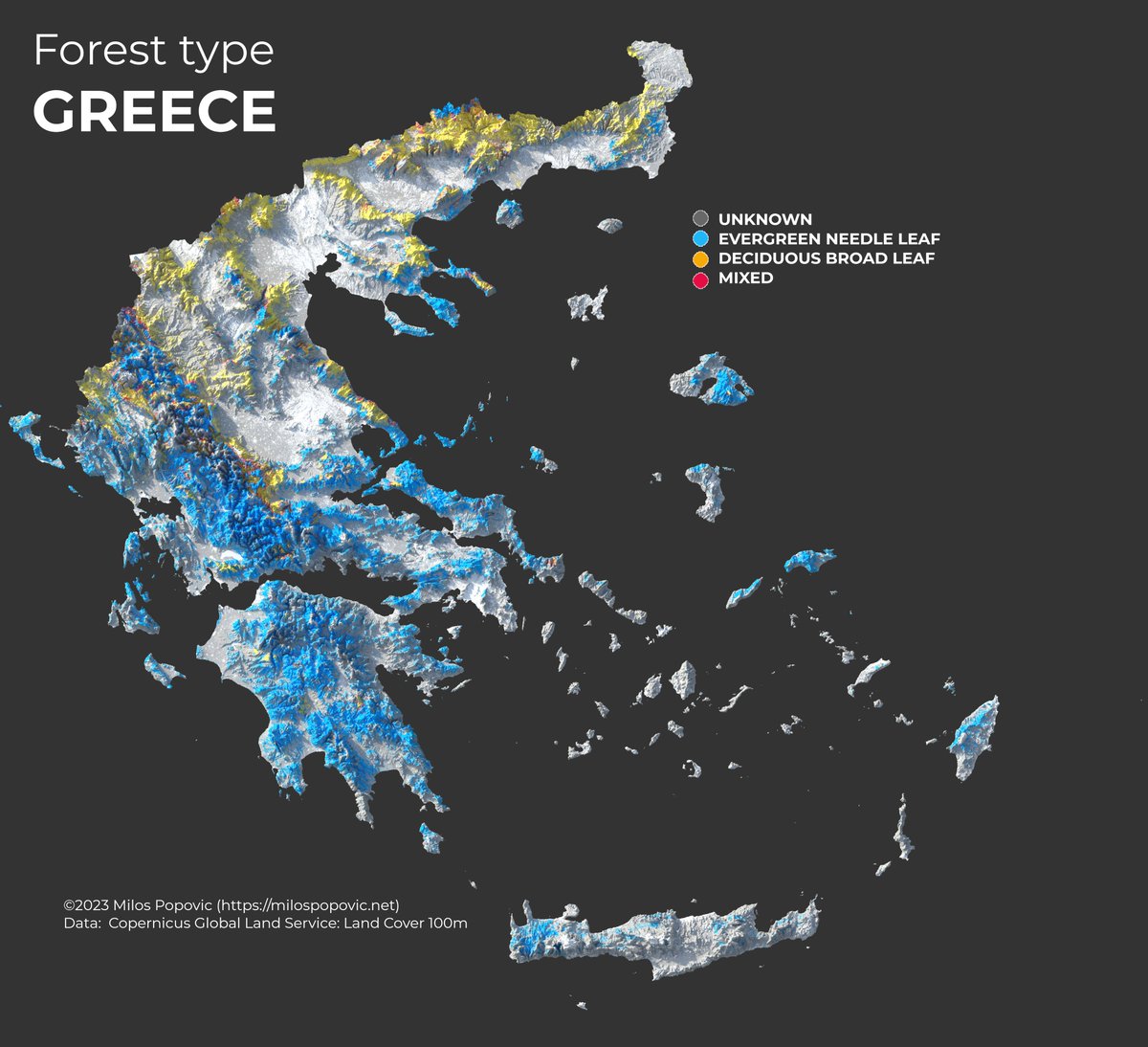
🌲🌲🌲 Did you know that Greece is home to some of the most stunning and diverse forests in Europe? Check out my new map I made using the Copernicus Global Land cover dataset at 100m for 2019.
Want to learn how to make your own maps like this? Click here to watch it: 🔗lnkd.in/eKJcsrnY
#Greece #Forests #NatureLovers #mapmagic #nature #environment #RStats #DataScience #dataviz #datavisualization #visualization #maps #mapping #cartography
2
3
1,403
25 Dec 2023
23 Dec 2023
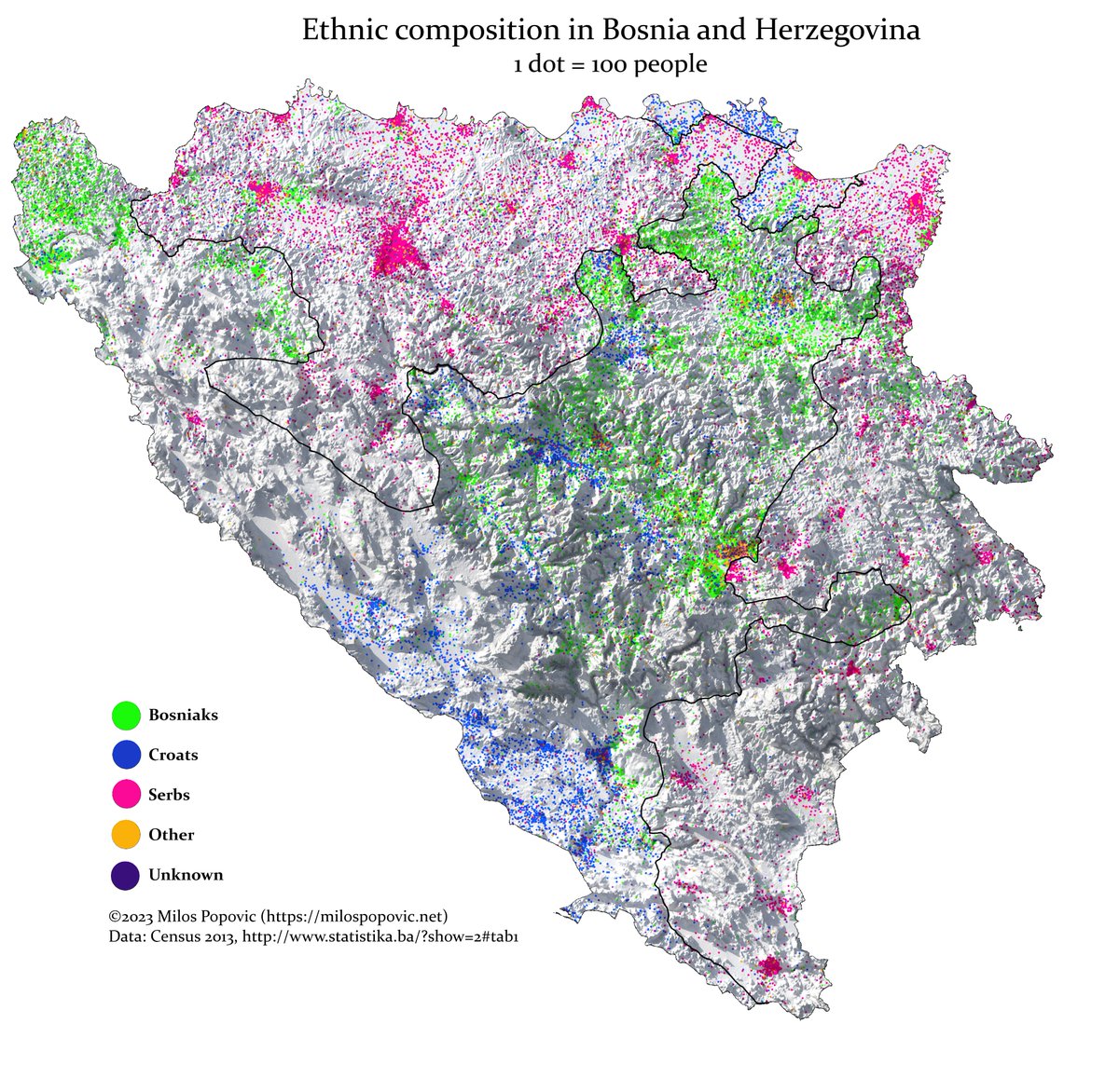
You won’t believe how diverse Bosnia’s population is! 😍 I used R to make this 3D relief and dot-density map of the ethnic groups in each settlement according to the 2013 population census. Can you tell them apart? 🤔
#BosniaHerzegovina #BIH #RepublikaSrpska #census #demography #population #maps #mapping #rstats #dataviz #datavisualization #visualization #cartography #geospatialdata #Geography #spatial #artwork #visualart
1
4
2,136